


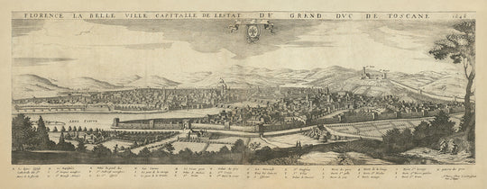


Old Birdseye Map of Florence by Boisseau, 1648: Cathedral, Baptistery, Medici Palace, Arno River, City Walls

-
![]() Handmade in Canada
Handmade in Canada
-
FREE worldwide delivery in 2-3 days ⓘ
Free Christmas delivery in 2-3 days
Your map should be delivered in 2-3 working days with free delivery, worldwide.
We make maps by hand locally in 23 countries, including Canada
![]() . If you're buying a gift for someone in another country, we will make the map locally to them.
. If you're buying a gift for someone in another country, we will make the map locally to them.You will never pay import tax or customs duty.
Check the Christmas delivery guide for order deadlines.
Express delivery is available at checkout which can reduce the delivery time to 1-2 days.
Please note that personalised maps, and larger framed maps, can take longer to produce and deliver.
If you need your order to arrive by a certain date, contact me and we can discuss your options.
-
90 day money back guarantee
ⓘ
90 days to return and refund
Products can be returned within 90 days for a full refund, or exchange for another product.
For personalised and custom made items, we may offer you store credit or a non-expiring gift card, as we cannot resell personalised orders.
If you have any questions, get in touch. For more information, see our full returns & exchanges policy.

My maps are rare, museum-grade, restored old maps sourced from libraries, auction houses and private collections across the globe.
Framing & free personalisation available
1. Select your size
2. Frame & personalise your map
Make your map unique with framing, hand-drawn customisation, vintage ageing, pop art text, unique 3D styling and moreGift message & custom finish

If you want to add a gift message, or a finish (jigsaw, aluminium board, etc.) that is not available here, please request it in the "order note" when you check out.
Every order is custom made, so if you need the size adjusted slightly, or printed on an unusual material, just let us know. We've done thousands of custom orders over the years, so there's (almost) nothing we can't manage.
You can also contact us before you order, if you prefer!

- Handmade locally. No import duty or tax
- FREE Delivery. Arrives in 2-3 days
- Love it or your money back
- Questions? WhatsApp me any time
Own a piece of history
5,000+ 5 star reviews


"Florence La Belle Ville Capitalle De L Estat De Grand Duc de Toscane," crafted by the esteemed Jean Boisseau in 1648, is a captivating birdseye view of Florence, Italy. This rare and detailed map provides a panoramic glimpse into the heart of Tuscany during the mid-17th century. Boisseau, a renowned French engraver and mapmaker, has masterfully captured the essence of Florence, highlighting its architectural grandeur and the intricate urban layout that defines this historic city.
The map meticulously showcases significant landmarks that have shaped Florence's identity. The iconic dome of the Cathedral, known as Le dome Eglise, stands prominently, symbolizing the city's architectural prowess. Nearby, the Baptistery (Le Baptistère) and the Grand Duke's Palace (Palais du grand duc) further emphasize Florence's rich cultural heritage. The Medici Palace (Palais de Medicis) and Santa Maria Novella (St. Marie la novelle) are also prominently featured, underscoring the city's importance as a center of art and power during the Renaissance.
Boisseau's map is not just a depiction of buildings; it is a narrative of Florence's vibrant neighborhoods and their historical significance. The clustered buildings represent the bustling urban life, while the detailed city walls and gates, such as Porte de la Croix and Porte de St. George, offer a glimpse into the city's defensive structures. The Arno River (Arne Fleuve) gracefully winds through the city, serving as both a vital waterway and a picturesque element of the landscape, further enhancing the map's visual appeal.
The surrounding hills and green spaces depicted on the map highlight the natural beauty that frames Florence. Gardens and parks within and around the city walls provide a sense of tranquility amidst the urban sprawl. These green spaces, along with the bridges over the Arno River, such as the Ponte Vecchio, are testament to the city's harmonious blend of nature and architecture, making Florence a unique and enchanting destination.
Jean Boisseau's "Florence La Belle Ville Capitalle De L Estat De Grand Duc de Toscane" is more than just a map; it is a historical document that captures the essence of Florence in the 17th century. The detailed illustrations and the comprehensive legend, which identifies over 30 places of importance, make this map an invaluable resource for historians and enthusiasts alike. Boisseau's work, part of his rare Théâtre des Citez collection, stands as a testament to his skill and the enduring allure of Florence.
Streets and roads on this map
- Porte de la Croix
- Porte de prez
- Porte de St. Fran
- Porte de St. George
- Porte de St. Gallo
- Porte de St. Nicolas
- Porte de St. Pierre Gatinini
- Porte de St. Miniate
- Porte de prez
Notable Features & Landmarks
- Illustrations:
- Detailed depiction of Florence's cityscape.
- Surrounding hills and landscape.
- Landmarks:
- Le dome Eglise (Cathedral)
- Le Baptistère (Baptistery)
- Palais du grand duc (Grand Duke's Palace)
- Palais de Medicis (Medici Palace)
- St. Marie la novelle (Santa Maria Novella)
- St. Croix (Santa Croce)
- St. Michel
- St. Franc (San Francesco)
- La nonciade
- St. Onofrius (San Onofrio)
- Tour les Sainctz (Tower of Saints)
- St. Felix (San Felice)
- Palais de Strozzi (Strozzi Palace)
- Neighbourhoods:
- Various clustered buildings representing different parts of the city.
- Lakes:
- The Arno River (Arne Fleuve)
- Large parks:
- Gardens and green spaces surrounding the city walls.
- Other notable features:
- City walls and gates.
- Bridges over the Arno River.
Historical and design context
- Name of the map: Florence La Belle Ville Capitalle De L Estat De Grand Duc de Toscane
- Date of creation: 1648
- Mapmaker/Publisher: Jean Boisseau
- Interesting context about the mapmaker: Jean Boisseau was a notable French engraver and mapmaker known for his detailed city views and panoramas.
- Topics and themes:
- City Birds Eye View: The map provides a panoramic, birds-eye view of Florence.
- Architectural landmarks: Key buildings and landmarks are identified and labeled.
- Geographical features: The Arno River and surrounding hills are depicted.
- Countries and regions shown: Florence, Tuscany, Italy
- Design/Style:
- Pictorial map: The map is a pictorial representation, providing a detailed and artistic view of the city.
- Panoramic layout: The map uses a panoramic layout to capture the cityscape.
- Historical significance:
- The map provides a historical snapshot of Florence in the mid-17th century, showcasing its architecture and urban layout.
- It reflects the cartographic and artistic techniques of the period.
Please double check the images to make sure that a specific town or place is shown on this map. You can also get in touch and ask us to check the map for you.
This map looks great at every size, but I always recommend going for a larger size if you have space. That way you can easily make out all of the details.
This map looks amazing at sizes all the way up to 100in (250cm). If you are looking for a larger map, please get in touch.
This map is wider than most maps, which would make it a perfect statement piece above a mantelpiece, sofa or desk.
The fifth listing image shows an example of my map personalisation service.
If you’re looking for something slightly different, check out my collection of the best old maps to see if something else catches your eye.
Please contact me to check if a certain location, landmark or feature is shown on this map.
This would make a wonderful birthday, Christmas, Father's Day, work leaving, anniversary or housewarming gift for someone from the areas covered by this map.
This map is available as a giclée print on acid free archival matte paper, or you can buy it framed. The frame is a nice, simple black frame that suits most aesthetics. Please get in touch if you'd like a different frame colour or material. My frames are glazed with super-clear museum-grade acrylic (perspex/acrylite), which is significantly less reflective than glass, safer, and will always arrive in perfect condition.
This map is also available as a float framed canvas, sometimes known as a shadow gap framed canvas or canvas floater. The map is printed on artist's cotton canvas and then stretched over a handmade box frame. We then "float" the canvas inside a wooden frame, which is available in a range of colours (black, dark brown, oak, antique gold and white). This is a wonderful way to present a map without glazing in front. See some examples of float framed canvas maps and explore the differences between my different finishes.
For something truly unique, this map is also available in "Unique 3D", our trademarked process that dramatically transforms the map so that it has a wonderful sense of depth. We combine the original map with detailed topography and elevation data, so that mountains and the terrain really "pop". For more info and examples of 3D maps, check my Unique 3D page.
For most orders, delivery time is about 3 working days. Personalised and customised products take longer, as I have to do the personalisation and send it to you for approval, which usually takes 1 or 2 days.
Please note that very large framed orders usually take longer to make and deliver.
If you need your order to arrive by a certain date, please contact me before you order so that we can find the best way of making sure you get your order in time.
I print and frame maps and artwork in 23 countries around the world. This means your order will be made locally, which cuts down on delivery time and ensures that it won't be damaged during delivery. You'll never pay customs or import duty, and we'll put less CO2 into the air.
All of my maps and art prints are well packaged and sent in a rugged tube if unframed, or surrounded by foam if framed.
I try to send out all orders within 1 or 2 days of receiving your order, though some products (like face masks, mugs and tote bags) can take longer to make.
If you select Express Delivery at checkout your order we will prioritise your order and send it out by 1-day courier (Fedex, DHL, UPS, Parcelforce).
Next Day delivery is also available in some countries (US, UK, Singapore, UAE) but please try to order early in the day so that we can get it sent out on time.
My standard frame is a gallery style black ash hardwood frame. It is simple and quite modern looking. My standard frame is around 20mm (0.8in) wide.
I use super-clear acrylic (perspex/acrylite) for the frame glass. It's lighter and safer than glass - and it looks better, as the reflectivity is lower.
Six standard frame colours are available for free (black, dark brown, dark grey, oak, white and antique gold). Custom framing and mounting/matting is available if you're looking for something else.
Most maps, art and illustrations are also available as a framed canvas. We use matte (not shiny) cotton canvas, stretch it over a sustainably sourced box wood frame, and then 'float' the piece within a wood frame. The end result is quite beautiful, and there's no glazing to get in the way.
All frames are provided "ready to hang", with either a string or brackets on the back. Very large frames will have heavy duty hanging plates and/or a mounting baton. If you have any questions, please get in touch.
See some examples of my framed maps and framed canvas maps.
Alternatively, I can also supply old maps and artwork on canvas, foam board, cotton rag and other materials.
If you want to frame your map or artwork yourself, please read my size guide first.
My maps are extremely high quality reproductions of original maps.
I source original, rare maps from libraries, auction houses and private collections around the world, restore them at my London workshop, and then use specialist giclée inks and printers to create beautiful maps that look even better than the original.
My maps are printed on acid-free archival matte (not glossy) paper that feels very high quality and almost like card. In technical terms the paper weight/thickness is 10mil/200gsm. It's perfect for framing.
I print with Epson ultrachrome giclée UV fade resistant pigment inks - some of the best inks you can find.
I can also make maps on canvas, cotton rag and other exotic materials.
Learn more about The Unique Maps Co.
Map personalisation
If you're looking for the perfect anniversary or housewarming gift, I can personalise your map to make it truly unique. For example, I can add a short message, or highlight an important location, or add your family's coat of arms.
The options are almost infinite. Please see my map personalisation page for some wonderful examples of what's possible.
To order a personalised map, select "personalise your map" before adding it to your basket.
Get in touch if you're looking for more complex customisations and personalisations.
Map ageing
I have been asked hundreds of times over the years by customers if they could buy a map that looks even older.
Well, now you can, by selecting Aged before you add a map to your basket.
All the product photos you see on this page show the map in its Original form. This is what the map looks like today.
If you select Aged, I will age your map by hand, using a special and unique process developed through years of studying old maps, talking to researchers to understand the chemistry of aging paper, and of course... lots of practice!
If you're unsure, stick to the Original colour of the map. If you want something a bit darker and older looking, go for Aged.
If you are not happy with your order for any reason, contact me and I'll get it fixed ASAP, free of charge. Please see my returns and refund policy for more information.
I am very confident you will like your restored map or art print. I have been doing this since 1984. I'm a 5-star Etsy seller. I have sold tens of thousands of maps and art prints and have over 5,000 real 5-star reviews. My work has been featured in interior design magazines, on the BBC, and on the walls of dozens of 5-star hotels.
I use a unique process to restore maps and artwork that is massively time consuming and labour intensive. Hunting down the original maps and illustrations can take months. I use state of the art and eye-wateringly expensive technology to scan and restore them. As a result, I guarantee my maps and art prints are a cut above the rest. I stand by my products and will always make sure you're 100% happy with what you receive.
Almost all of my maps and art prints look amazing at large sizes (200cm, 6.5ft+) and I can frame and deliver them to you as well, via special oversized courier. Contact me to discuss your specific needs.
Or try searching for something!


