


Old Birdseye Map of Venice by Boisseau, 1648: St. Mark's Basilica, Doge's Palace, Rialto Bridge, Grand Canal, Venetian Lagoon

-
![]() Handmade in Canada
Handmade in Canada
-
FREE worldwide delivery in 2-3 days ⓘ
Free Christmas delivery in 2-3 days
Your map should be delivered in 2-3 working days with free delivery, worldwide.
We make maps by hand locally in 23 countries, including Canada
![]() . If you're buying a gift for someone in another country, we will make the map locally to them.
. If you're buying a gift for someone in another country, we will make the map locally to them.You will never pay import tax or customs duty.
Check the Christmas delivery guide for order deadlines.
Express delivery is available at checkout which can reduce the delivery time to 1-2 days.
Please note that personalised maps, and larger framed maps, can take longer to produce and deliver.
If you need your order to arrive by a certain date, contact me and we can discuss your options.
-
90 day money back guarantee
ⓘ
90 days to return and refund
Products can be returned within 90 days for a full refund, or exchange for another product.
For personalised and custom made items, we may offer you store credit or a non-expiring gift card, as we cannot resell personalised orders.
If you have any questions, get in touch. For more information, see our full returns & exchanges policy.

My maps are rare, museum-grade, restored old maps sourced from libraries, auction houses and private collections across the globe.
Framing & free personalisation available
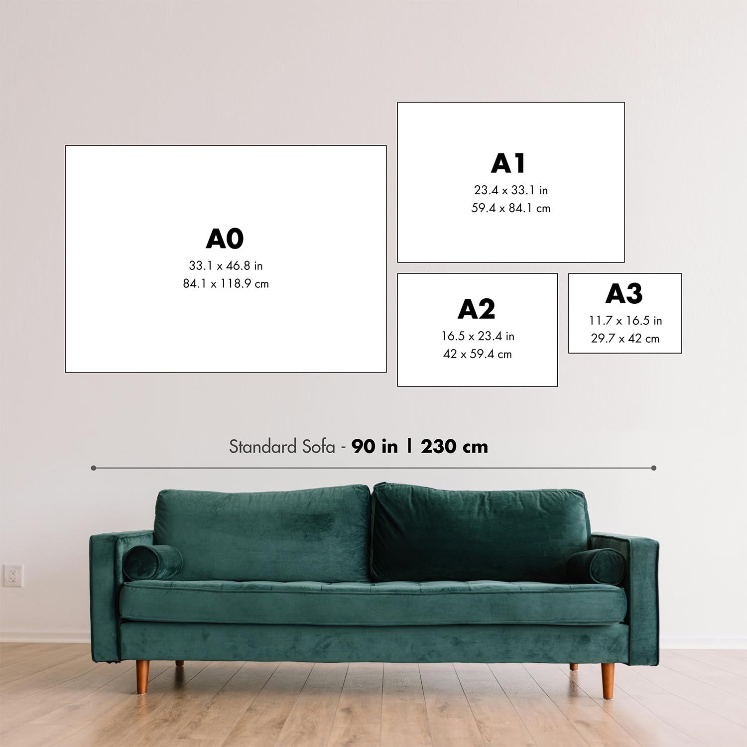
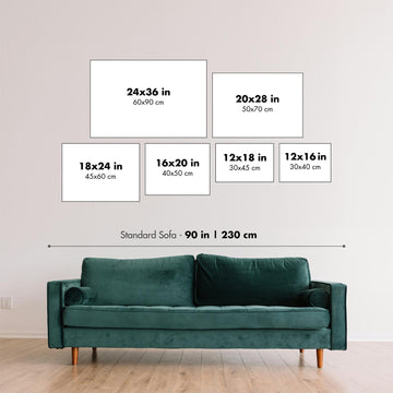
1. Select your size
2. Frame & personalise your map
Make your map unique with framing, hand-drawn customisation, vintage ageing, pop art text, unique 3D styling and moreGift message & custom finish

If you want to add a gift message, or a finish (jigsaw, aluminium board, etc.) that is not available here, please request it in the "order note" when you check out.
Every order is custom made, so if you need the size adjusted slightly, or printed on an unusual material, just let us know. We've done thousands of custom orders over the years, so there's (almost) nothing we can't manage.
You can also contact us before you order, if you prefer!

- Handmade locally. No import duty or tax
- FREE Delivery. Arrives in 2-3 days
- Love it or your money back
- Questions? WhatsApp me any time
Own a piece of history
5,000+ 5 star reviews


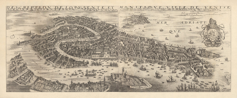
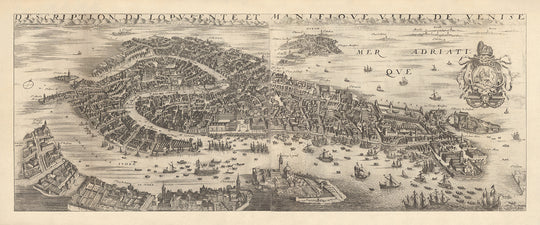
The "Description De L'Opulente et Manifique Ville de Venise," crafted by the esteemed French atlas maker and royal cartographer Jean Boisseau in 1648, is a breathtaking bird's eye view of Venice. This rare map offers an intricate depiction of the city during its historical decline from power, capturing the essence of Venice's architectural grandeur and bustling maritime activities. The map's detailed illustrations highlight the city's unique layout, with its main island and surrounding islets prominently featured, making it an invaluable piece for any collector or history enthusiast.
Venice, renowned for its intricate network of canals and stunning architecture, is beautifully represented in this map. Notable landmarks such as St. Mark's Basilica, the Doge's Palace, and the iconic Rialto Bridge are easily identifiable, showcasing the city's rich cultural heritage. The Grand Canal, a vital waterway that opens onto the Adriatic Sea, is depicted with numerous sailing and merchant vessels, reflecting Venice's thriving trade during the 17th century. Smaller boats and gondolas navigating through the islands and canals further enhance the map's authenticity and charm.
The map also provides a detailed view of the islands in the Venetian Lagoon, including San Giorgio, Murano, Burano, and Torcello. Each island is illustrated with remarkable precision, highlighting their unique features and historical significance. The depiction of these islands underscores Venice's strategic importance and its role as a major maritime hub. The inclusion of the mainland in the background adds depth to the map, offering a comprehensive view of the region's geography.
Jean Boisseau's expertise as a royal cartographer is evident in the meticulous detail and artistic flair of this map. His work not only serves as a geographical guide but also as a historical document, capturing Venice's splendor during a period of significant change. The map's design, with its intricate illustrations and careful labeling of buildings and landmarks, reflects Boisseau's dedication to accuracy and his deep understanding of the city's layout and history.
The intriguing coat of arms featured on the map, with its depiction of St. Marc's lion, a Doge's cap, and ribbons, adds a unique touch to this already remarkable piece. The unusual animalian face under the cap is a fascinating detail that invites further exploration and interpretation. This map, published in the exceedingly rare "Atlas du Théâtre des Citez," is not only a testament to Venice's enduring legacy but also a tribute to Boisseau's exceptional skill and artistry as a cartographer.
Streets and roads on this map
- La Judeé
- St. François
- St. Lucie
- St. Marc's lion
- St. Pierre de Castillon
Notable Features & Landmarks
- Numerous sailing and merchant vessels in the Grand Canal and Adriatic Sea.
- Gondolas and smaller boats traveling throughout the islands and canals.
- St. Mark's Basilica
- Doge's Palace
- Rialto bridge
- St. Pierre de Castillon
- St. Marc's lion depicted in the coat of arms
- St. Lucie
- St. Francois
- Detailed depictions of the islands in the Venetian Lagoon, including San Giorgio, Murano, Burano, and Torcello.
Historical and design context
- Name of the map: Description De L'Opulente et Manifique Ville de Venise
- Creation date: 1648
- Mapmaker/Publisher: Jean Boisseau, a French atlas maker and royal cartographer.
- Interesting context about the mapmaker: Jean Boisseau was known for his detailed and artistic cartographic works. He served as a royal cartographer, which highlights the significance and accuracy of his maps.
- Topics and themes shown on the map:
- Bird's eye view: The map provides a detailed bird's eye view of Venice, focusing on the main island and surrounding islets.
- Architecture and landmarks: Individual buildings such as St. Mark's Basilica, the Doge's Palace, and the Rialto bridge are identifiable and named.
- Harbor and canals: The harbor and canals are illustrated with numerous sailing and merchant vessels, gondolas, and smaller boats.
- Islands in the Venetian Lagoon: Detailed depiction of islands like San Giorgio, Murano, Burano, and Torcello.
- Coat of arms: Includes typical imagery of St. Marc's lion, a Doge's cap, and ribbons, with an unusual animalian face under the cap.
- Countries and regions shown on the map: The map primarily focuses on Venice and the Venetian Lagoon, with the mainland visible in the background.
- Design or style: The map is a pictorial bird's eye view, richly detailed with illustrations of buildings, vessels, and the city's layout.
- Historical significance:
- Venice's decline from power: The map portrays Venice during its three-century decline from power, highlighting the city's continued trade activities despite challenges.
- Published in a rare atlas: This work was published in the now exceedingly rare "Atlas du Théâtre des Citez," adding to its historical and collectible value.
Please double check the images to make sure that a specific town or place is shown on this map. You can also get in touch and ask us to check the map for you.
This map looks great at every size, but I always recommend going for a larger size if you have space. That way you can easily make out all of the details.
This map looks amazing at sizes all the way up to 100in (250cm). If you are looking for a larger map, please get in touch.
This map is wider than most maps, which would make it a perfect statement piece above a mantelpiece, sofa or desk.
The fifth listing image shows an example of my map personalisation service.
If you’re looking for something slightly different, check out my collection of the best old maps to see if something else catches your eye.
Please contact me to check if a certain location, landmark or feature is shown on this map.
This would make a wonderful birthday, Christmas, Father's Day, work leaving, anniversary or housewarming gift for someone from the areas covered by this map.
This map is available as a giclée print on acid free archival matte paper, or you can buy it framed. The frame is a nice, simple black frame that suits most aesthetics. Please get in touch if you'd like a different frame colour or material. My frames are glazed with super-clear museum-grade acrylic (perspex/acrylite), which is significantly less reflective than glass, safer, and will always arrive in perfect condition.
This map is also available as a float framed canvas, sometimes known as a shadow gap framed canvas or canvas floater. The map is printed on artist's cotton canvas and then stretched over a handmade box frame. We then "float" the canvas inside a wooden frame, which is available in a range of colours (black, dark brown, oak, antique gold and white). This is a wonderful way to present a map without glazing in front. See some examples of float framed canvas maps and explore the differences between my different finishes.
For something truly unique, this map is also available in "Unique 3D", our trademarked process that dramatically transforms the map so that it has a wonderful sense of depth. We combine the original map with detailed topography and elevation data, so that mountains and the terrain really "pop". For more info and examples of 3D maps, check my Unique 3D page.
For most orders, delivery time is about 3 working days. Personalised and customised products take longer, as I have to do the personalisation and send it to you for approval, which usually takes 1 or 2 days.
Please note that very large framed orders usually take longer to make and deliver.
If you need your order to arrive by a certain date, please contact me before you order so that we can find the best way of making sure you get your order in time.
I print and frame maps and artwork in 23 countries around the world. This means your order will be made locally, which cuts down on delivery time and ensures that it won't be damaged during delivery. You'll never pay customs or import duty, and we'll put less CO2 into the air.
All of my maps and art prints are well packaged and sent in a rugged tube if unframed, or surrounded by foam if framed.
I try to send out all orders within 1 or 2 days of receiving your order, though some products (like face masks, mugs and tote bags) can take longer to make.
If you select Express Delivery at checkout your order we will prioritise your order and send it out by 1-day courier (Fedex, DHL, UPS, Parcelforce).
Next Day delivery is also available in some countries (US, UK, Singapore, UAE) but please try to order early in the day so that we can get it sent out on time.
My standard frame is a gallery style black ash hardwood frame. It is simple and quite modern looking. My standard frame is around 20mm (0.8in) wide.
I use super-clear acrylic (perspex/acrylite) for the frame glass. It's lighter and safer than glass - and it looks better, as the reflectivity is lower.
Six standard frame colours are available for free (black, dark brown, dark grey, oak, white and antique gold). Custom framing and mounting/matting is available if you're looking for something else.
Most maps, art and illustrations are also available as a framed canvas. We use matte (not shiny) cotton canvas, stretch it over a sustainably sourced box wood frame, and then 'float' the piece within a wood frame. The end result is quite beautiful, and there's no glazing to get in the way.
All frames are provided "ready to hang", with either a string or brackets on the back. Very large frames will have heavy duty hanging plates and/or a mounting baton. If you have any questions, please get in touch.
See some examples of my framed maps and framed canvas maps.
Alternatively, I can also supply old maps and artwork on canvas, foam board, cotton rag and other materials.
If you want to frame your map or artwork yourself, please read my size guide first.
My maps are extremely high quality reproductions of original maps.
I source original, rare maps from libraries, auction houses and private collections around the world, restore them at my London workshop, and then use specialist giclée inks and printers to create beautiful maps that look even better than the original.
My maps are printed on acid-free archival matte (not glossy) paper that feels very high quality and almost like card. In technical terms the paper weight/thickness is 10mil/200gsm. It's perfect for framing.
I print with Epson ultrachrome giclée UV fade resistant pigment inks - some of the best inks you can find.
I can also make maps on canvas, cotton rag and other exotic materials.
Learn more about The Unique Maps Co.
Map personalisation
If you're looking for the perfect anniversary or housewarming gift, I can personalise your map to make it truly unique. For example, I can add a short message, or highlight an important location, or add your family's coat of arms.
The options are almost infinite. Please see my map personalisation page for some wonderful examples of what's possible.
To order a personalised map, select "personalise your map" before adding it to your basket.
Get in touch if you're looking for more complex customisations and personalisations.
Map ageing
I have been asked hundreds of times over the years by customers if they could buy a map that looks even older.
Well, now you can, by selecting Aged before you add a map to your basket.
All the product photos you see on this page show the map in its Original form. This is what the map looks like today.
If you select Aged, I will age your map by hand, using a special and unique process developed through years of studying old maps, talking to researchers to understand the chemistry of aging paper, and of course... lots of practice!
If you're unsure, stick to the Original colour of the map. If you want something a bit darker and older looking, go for Aged.
If you are not happy with your order for any reason, contact me and I'll get it fixed ASAP, free of charge. Please see my returns and refund policy for more information.
I am very confident you will like your restored map or art print. I have been doing this since 1984. I'm a 5-star Etsy seller. I have sold tens of thousands of maps and art prints and have over 5,000 real 5-star reviews. My work has been featured in interior design magazines, on the BBC, and on the walls of dozens of 5-star hotels.
I use a unique process to restore maps and artwork that is massively time consuming and labour intensive. Hunting down the original maps and illustrations can take months. I use state of the art and eye-wateringly expensive technology to scan and restore them. As a result, I guarantee my maps and art prints are a cut above the rest. I stand by my products and will always make sure you're 100% happy with what you receive.
Almost all of my maps and art prints look amazing at large sizes (200cm, 6.5ft+) and I can frame and deliver them to you as well, via special oversized courier. Contact me to discuss your specific needs.
Or try searching for something!


