


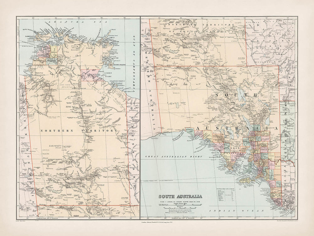
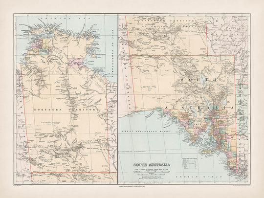


Old County Map of South Australia by Stanford, 1904: Adelaide, Murray River, Lake Eyre, Flinders Ranges, Railways
20% off 2 — 33% off 3
Add any two eligible items to your bag to receive 20% off. Add a third and it will be complimentary (equivalent to 33% off when purchasing three).
No code needed — the offer applies automatically at checkout.
Valid on all standard maps and fine art prints. You can mix and match any designs.
If you’d like to ship items to multiple addresses, please contact us before placing your order.
Custom and bespoke commissions are excluded.
Contact us if you have any questions
-
![]() Handmade in Canada
Handmade in Canada

-
FREE worldwide delivery in 2-3 days ⓘ
Free delivery in 2-3 days
Your map should be delivered in 2-3 working days with free delivery, worldwide.
We make maps by hand locally in 23 countries, including Canada
![]() . If you're buying a gift for someone in another country, we will make the map locally to them.
. If you're buying a gift for someone in another country, we will make the map locally to them.You will never pay import tax or customs duty.
Express delivery is available at checkout which can reduce the delivery time to 1-2 days.
Please note that personalised maps, and larger framed maps, can take longer to produce and deliver.
If you need your order to arrive by a certain date, contact me and we can discuss your options.
-
Complimentary gifting & design advice
ⓘ
Complimentary gifting & design advice
Available almost 24/7 on WhatsApp and email — we usually reply within minutes. We can help you:
- Choose a perfectly personalised gift
- Send a digital gift preview to the recipient
- Pick the ideal size for your wall
- Select the right finish and frame
Quick, friendly advice so you can order with confidence.
For last minute gifts, consider buying a digital gift card. We have over 5,000 maps and art prints to choose from.
-
90-day returns & 5-year guarantee
ⓘ
90-day returns & 5-year guarantee
Products can be returned within 90 days for a full refund, or exchange for another product.
We are also proud to offer a 5-year quality guarantee on our maps and art, covering defects in materials or workmanship under normal use.
For personalised and custom made items, we may offer you store credit or a non-expiring gift card, as we cannot resell personalised orders.
If you have any questions, get in touch. For more information, see our full returns & exchanges policy.

This is a museum-grade archival print from the original 1904 map — restored in our workshop and made to order on 220gsm archival matte paper or 400gsm artist's cotton canvas with pigment inks.
Professional framing & free personalisation available.
1. Choose a size
2. Frame & personalise your map
Make your map unique with framing, hand-drawn customisation, vintage ageing, pop art text, unique 3D styling and more.


Gift message & custom finish

If you want to add a gift message, or a finish (jigsaw, aluminium board, etc.) that is not available here, please request it in the "order note" when you check out.
Every order is custom made, so if you need the size adjusted slightly, or printed on an unusual material, just let us know. We've done thousands of custom orders over the years, so there's (almost) nothing we can't manage.
You can also contact us before you order, if you prefer!

- Handmade locally. No import duty or tax
- FREE worldwide delivery
- 90-day returns & 5-year product guarantee
- Questions? WhatsApp me any time
Own a piece of history
7,000+ 5 star reviews


Step into the vivid world of Edward Stanford’s cartographic mastery with the 1904 map titled “South Australia.” This extraordinary piece is more than a geographical document—it is a window into the early 20th-century colonial landscape, where the ambitions of explorers, settlers, and administrators converged on the vast Australian continent. Stanford’s map, with its original, evocative title, captures the essence of South Australia at a pivotal moment, just a few years after Federation. It is a testament to the precision and artistry of British mapmaking, designed to guide, inform, and inspire those seeking to understand the region’s evolving identity.
Edward Stanford, a titan of Victorian and Edwardian cartography, inherited and elevated the legacy of John Arrowsmith, whose plates he acquired after Arrowsmith’s passing. Stanford’s London Atlas, from which this map is drawn, became the gold standard for geographic reference in the English-speaking world. Through meticulous full-color lithography, Stanford imbued each county with vibrant hues, while employing hachures and spot heights to render the terrain with remarkable clarity. His maps are celebrated not only for their technical accuracy but also for their elegance and legibility, qualities that have made them enduring objects of fascination and study.
The map’s design is a harmonious blend of political and physical detail. Counties are boldly delineated, their boundaries rendered in striking colors that distinguish each jurisdiction. Major rivers, such as the mighty Murray, meander across the landscape, while vast salt lakes—Lake Eyre and Lake Torrens—punctuate the arid interior. The Flinders Ranges rise from the plains, their rugged contours depicted with delicate hachures, and the twin arms of Spencer Gulf and Gulf St Vincent embrace the fertile coastal heartland. Coastal features like Kangaroo Island and the dramatic outlines of the Yorke and Eyre Peninsulas complete a portrait of a land both untamed and increasingly interconnected.
Stanford’s 1904 map is a chronicle of South Australia’s burgeoning infrastructure. It traces the web of telegraph lines and railways that stitched distant settlements into a nascent network of commerce and communication. Roads snake between towns such as Adelaide, Mount Gambier, and Port Augusta, while the map’s large inset of the Northern Territory reminds us of the administrative ties that once bound these vast regions together. The grid of latitude and longitude, along with clearly marked borders with New South Wales, Victoria, and Western Australia, situates South Australia within the broader tapestry of a continent in transformation.
Beyond its immediate utility, this map stands as a historical artifact of profound significance. It captures the optimism and complexity of a society on the threshold of modernity, balancing the demands of exploration, settlement, and governance. While national parks and protected areas were yet to be formally mapped, the landscape’s natural grandeur is unmistakable. For collectors, historians, and lovers of cartographic art, Edward Stanford’s “South Australia” is an invitation to journey through time, tracing the contours of a land whose story is still unfolding.
Cities and towns on this map
- Adelaide
- Mount Gambier
- Whyalla
- Port Augusta
- Port Pirie
- Murray Bridge
- Gawler
- Port Lincoln
- Victor Harbor
- Kadina
- Moonta
- Wallaroo
- Peterborough
- Clare
- Burra
- Kapunda
- Naracoorte
- Millicent
- Robe
- Penola
- Bordertown
- Kingston SE
- Cowell
- Tumby Bay
- Orroroo
- Jamestown
- Quorn
- Crystal Brook
- Snowtown
- Melrose
- Wilmington
- Riverton
- Balaklava
- Gladstone
- Laura
- Port Wakefield
- Eudunda
- Minlaton
- Yorketown
- Streaky Bay
- Elliston
- Kimba
- Ceduna
- Pinnaroo
- Lameroo
- Tailem Bend
- Mannum
- Morgan
- Renmark
- Berri
- Loxton
- Waikerie
- Barmera
- Tarcoola
- Darwin (may be labelled as Palmerston or Port Darwin)
- Katherine
- Tennant Creek
- Alice Springs (may be absent or labelled as Stuart)
- Borroloola
Notable Features & Landmarks
- Clearly defined county boundaries throughout South Australia, each vibrantly color-coded
- Major rivers including the Murray River, which is prominently depicted
- Lake Eyre, a significant inland salt lake
- Lake Torrens, another major salt lake
- Flinders Ranges, shown with hachures to indicate mountainous terrain
- Spencer Gulf, a prominent body of water on the southern coast
- Gulf St Vincent, the other major gulf adjacent to Adelaide
- Yorke Peninsula, clearly outlined between the two gulfs
- Eyre Peninsula, west of Spencer Gulf
- Telegraph lines and routes, depicted with dashed or solid lines
- Railways and proposed railway lines, shown with distinct symbols
- Major road routes, connecting key settlements and regions
- The large inset map of the Northern Territory, showing its boundaries and major features
- Coastal features such as Kangaroo Island, depicted off the southern coast
- Hachure marks illustrating mountainous and hilly regions
- The border with New South Wales, Victoria, and Western Australia clearly marked
- Numerous salt lakes and smaller inland water bodies
- Latitude and longitude grid for precise location referencing
Historical and design context
- Date created: 1904
- Mapmaker/publisher: Edward Stanford, a renowned British cartographer and publisher who succeeded John Arrowsmith’s legacy
- Origin: Part of Stanford’s London Atlas, which succeeded John Arrowsmith’s influential 1858 London Atlas after Arrowsmith’s death
- Atlas history: First issued in 1887, with subsequent updated editions in 1893, 1896, 1898, 1901, and the third edition in 1904
- Printing technique: Full-color lithography with vibrant highlighting of counties
- Map style: Detailed political and physical map, showing counties, settlements, roads, railroads, and telegraph lines
- Relief depiction: Uses hachures and spot heights to illustrate terrain and topographical features
- Thematic content: Highlights political boundaries (counties), transportation infrastructure (roads, railways, telegraphs), and physical geography (mountains, rivers, lakes)
- Historical context: Captures the state of South Australia and the Northern Territory as administered in the early 20th century, shortly after Federation (1901)
- Significance: Provides a snapshot of colonial administration, infrastructure development, and exploration at a pivotal time in Australian history
- The map is an example of British imperial cartography, reflecting both administrative control and the mapping priorities of the era
Please double check the images to make sure that a specific town or place is shown on this map. You can also get in touch and ask us to check the map for you.
This map looks great at every size, but I always recommend going for a larger size if you have space. That way you can easily make out all of the details.
This map looks amazing at sizes all the way up to 70in (180cm). If you are looking for a larger map, please get in touch.
Please note: the labels on this map are hard to read if you order a map that is 16in (40cm) or smaller. The map is still very attractive, but if you would like to read the map easily, please buy a larger size.
The model in the listing images is holding the 18x24in (45x60cm) version of this map.
The fifth listing image shows an example of my map personalisation service.
If you’re looking for something slightly different, check out my collection of the best old maps to see if something else catches your eye.
Please contact me to check if a certain location, landmark or feature is shown on this map.
This would make a wonderful birthday, Christmas, Father's Day, work leaving, anniversary or housewarming gift for someone from the areas covered by this map.
This map is available as a giclée print on acid free archival matte paper, or you can buy it framed. The frame is a nice, simple black frame that suits most aesthetics. Please get in touch if you'd like a different frame colour or material. My frames are glazed with super-clear museum-grade acrylic (perspex/acrylite), which is significantly less reflective than glass, safer, and will always arrive in perfect condition.
This map is also available as a float framed canvas, sometimes known as a shadow gap framed canvas or canvas floater. The map is printed on artist's cotton canvas and then stretched over a handmade box frame. We then "float" the canvas inside a wooden frame, which is available in a range of colours (black, dark brown, oak, antique gold and white). This is a wonderful way to present a map without glazing in front. See some examples of float framed canvas maps and explore the differences between my different finishes.
For something truly unique, this map is also available in "Unique 3D", our trademarked process that dramatically transforms the map so that it has a wonderful sense of depth. We combine the original map with detailed topography and elevation data, so that mountains and the terrain really "pop". For more info and examples of 3D maps, check my Unique 3D page.
For most orders, delivery time is about 3 working days. Personalised and customised products take longer, as I have to do the personalisation and send it to you for approval, which usually takes 1 or 2 days.
Please note that very large framed orders usually take longer to make and deliver.
If you need your order to arrive by a certain date, please contact me before you order so that we can find the best way of making sure you get your order in time.
I print and frame maps and artwork in 23 countries around the world. This means your order will be made locally, which cuts down on delivery time and ensures that it won't be damaged during delivery. You'll never pay customs or import duty, and we'll put less CO2 into the air.
All of my maps and art prints are well packaged and sent in a rugged tube if unframed, or surrounded by foam if framed.
I try to send out all orders within 1 or 2 days of receiving your order, though some products (like face masks, mugs and tote bags) can take longer to make.
If you select Express Delivery at checkout your order we will prioritise your order and send it out by 1-day courier (Fedex, DHL, UPS, Parcelforce).
Next Day delivery is also available in some countries (US, UK, Singapore, UAE) but please try to order early in the day so that we can get it sent out on time.
My standard frame is a gallery style black ash hardwood frame. It is simple and quite modern looking. My standard frame is around 20mm (0.8in) wide.
I use super-clear acrylic (perspex/acrylite) for the frame glass. It's lighter and safer than glass - and it looks better, as the reflectivity is lower.
Six standard frame colours are available for free (black, dark brown, dark grey, oak, white and antique gold). Custom framing and mounting/matting is available if you're looking for something else.
Most maps, art and illustrations are also available as a framed canvas. We use matte (not shiny) cotton canvas, stretch it over a sustainably sourced box wood frame, and then 'float' the piece within a wood frame. The end result is quite beautiful, and there's no glazing to get in the way.
All frames are provided "ready to hang", with either a string or brackets on the back. Very large frames will have heavy duty hanging plates and/or a mounting baton. If you have any questions, please get in touch.
See some examples of my framed maps and framed canvas maps.
Alternatively, I can also supply old maps and artwork on canvas, foam board, cotton rag and other materials.
If you want to frame your map or artwork yourself, please read my size guide first.
My maps are extremely high quality reproductions of original maps.
I source original, rare maps from libraries, auction houses and private collections around the world, restore them at my London workshop, and then use specialist giclée inks and printers to create beautiful maps that look even better than the original.
My maps are printed on acid-free archival matte (not glossy) paper that feels very high quality and almost like card. In technical terms the paper weight/thickness is 10mil/200gsm. It's perfect for framing.
I print with Epson ultrachrome giclée UV fade resistant pigment inks - some of the best inks you can find.
I can also make maps on canvas, cotton rag and other exotic materials.
Learn more about The Unique Maps Co.
Map personalisation
If you're looking for the perfect anniversary or housewarming gift, I can personalise your map to make it truly unique. For example, I can add a short message, or highlight an important location, or add your family's coat of arms.
The options are almost infinite. Please see my map personalisation page for some wonderful examples of what's possible.
To order a personalised map, select "personalise your map" before adding it to your basket.
Get in touch if you're looking for more complex customisations and personalisations.
Map ageing
I have been asked hundreds of times over the years by customers if they could buy a map that looks even older.
Well, now you can, by selecting Aged before you add a map to your basket.
All the product photos you see on this page show the map in its Original form. This is what the map looks like today.
If you select Aged, I will age your map by hand, using a special and unique process developed through years of studying old maps, talking to researchers to understand the chemistry of aging paper, and of course... lots of practice!
If you're unsure, stick to the Original colour of the map. If you want something a bit darker and older looking, go for Aged.
If you are not happy with your order for any reason, contact me and I'll get it fixed ASAP, free of charge. Please see my returns and refund policy for more information.
I am very confident you will like your restored map or art print. I have been doing this since 1984. I'm a 5-star Etsy seller. I have sold tens of thousands of maps and art prints and have over 5,000 real 5-star reviews. My work has been featured in interior design magazines, on the BBC, and on the walls of dozens of 5-star hotels.
I use a unique process to restore maps and artwork that is massively time consuming and labour intensive. Hunting down the original maps and illustrations can take months. I use state of the art and eye-wateringly expensive technology to scan and restore them. As a result, I guarantee my maps and art prints are a cut above the rest. I stand by my products and will always make sure you're 100% happy with what you receive.
Almost all of my maps and art prints look amazing at large sizes (200cm, 6.5ft+) and I can frame and deliver them to you as well, via special oversized courier. Contact me to discuss your specific needs.
Or try searching for something!


