


Old Map of Europe by John Tallis, 1851: Seal Hunting, Camels, Slave Market, etc.
20% off 2 — 33% off 3
Add any two eligible items to your bag to receive 20% off. Add a third and it will be complimentary (equivalent to 33% off when purchasing three).
No code needed — the offer applies automatically at checkout.
Valid on all standard maps and fine art prints. You can mix and match any designs.
If you’d like to ship items to multiple addresses, please contact us before placing your order.
Custom and bespoke commissions are excluded.
Contact us if you have any questions
-
![]() Handmade in Canada
Handmade in Canada

-
FREE worldwide delivery in 2-3 days ⓘ
Free delivery in 2-3 days
Your map should be delivered in 2-3 working days with free delivery, worldwide.
We make maps by hand locally in 23 countries, including Canada
![]() . If you're buying a gift for someone in another country, we will make the map locally to them.
. If you're buying a gift for someone in another country, we will make the map locally to them.You will never pay import tax or customs duty.
Express delivery is available at checkout which can reduce the delivery time to 1-2 days.
Please note that personalised maps, and larger framed maps, can take longer to produce and deliver.
If you need your order to arrive by a certain date, contact me and we can discuss your options.
-
Complimentary gifting & design advice
ⓘ
Complimentary gifting & design advice
Available almost 24/7 on WhatsApp and email — we usually reply within minutes. We can help you:
- Choose a perfectly personalised gift
- Send a digital gift preview to the recipient
- Pick the ideal size for your wall
- Select the right finish and frame
Quick, friendly advice so you can order with confidence.
For last minute gifts, consider buying a digital gift card. We have over 5,000 maps and art prints to choose from.
-
90-day returns & 5-year guarantee
ⓘ
90-day returns & 5-year guarantee
Products can be returned within 90 days for a full refund, or exchange for another product.
We are also proud to offer a 5-year quality guarantee on our maps and art, covering defects in materials or workmanship under normal use.
For personalised and custom made items, we may offer you store credit or a non-expiring gift card, as we cannot resell personalised orders.
If you have any questions, get in touch. For more information, see our full returns & exchanges policy.

This is a museum-grade archival print from the original 1851 map — restored in our workshop and made to order on 220gsm archival matte paper or 400gsm artist's cotton canvas with pigment inks.
Professional framing & free personalisation available.
1. Choose a size
2. Frame & personalise your map
Make your map unique with framing, hand-drawn customisation, vintage ageing, pop art text, unique 3D styling and more.


Gift message & custom finish

If you want to add a gift message, or a finish (jigsaw, aluminium board, etc.) that is not available here, please request it in the "order note" when you check out.
Every order is custom made, so if you need the size adjusted slightly, or printed on an unusual material, just let us know. We've done thousands of custom orders over the years, so there's (almost) nothing we can't manage.
You can also contact us before you order, if you prefer!

- Handmade locally. No import duty or tax
- FREE worldwide delivery
- 90-day returns & 5-year product guarantee
- Questions? WhatsApp me any time
Own a piece of history
7,000+ 5 star reviews


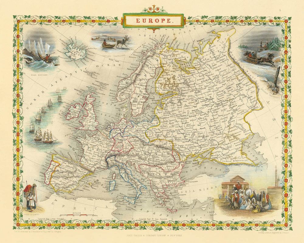
Step into the rich tapestry of nineteenth-century Europe with “Europe,” the original 1851 map masterfully crafted by John Tallis. Bearing its historic title, this map is more than a geographical record—it is a vivid window into a continent on the cusp of transformation. Commissioned for R. Montgomery Martin’s celebrated Illustrated Atlas, Tallis’s work encapsulates the political and physical landscape of Europe at a pivotal moment, when empires stretched across borders and the world’s attention was fixed on exploration, commerce, and cultural exchange.
John Tallis stands among the last great decorative mapmakers, renowned for his exquisite attention to detail and his ability to weave artistry into cartography. His maps are prized by collectors and historians alike, not only for their accuracy but for their beauty. This particular map showcases Tallis’s signature style: a finely engraved, full-color composition framed by an ornate decorative border, inviting viewers to linger over both the geography and the artistry. The meticulous rendering of mountain ranges, rivers, and coastlines reflects the high standards of Victorian-era mapmaking.
What sets this map apart are the evocative vignettes that surround the central image. Scenes such as the “Slave Market,” “Seal Hunting,” “Lapland Travellers,” and “Arabs and Camels” offer a glimpse into the economic, cultural, and ethnographic realities of the time. These illustrations are not mere embellishments; they are historical documents in their own right, capturing the fascination—and sometimes the prejudices—of nineteenth-century Europe with distant lands and peoples. The vignettes transform the map into a narrative, telling stories of commerce, travel, and encounter.
The map’s content is as comprehensive as it is beautiful. Major rivers like the Danube and Rhine, imposing mountain ranges such as the Alps and Carpathians, and significant bodies of water including the Mediterranean and Baltic Seas are all clearly delineated. Key cities—London, Paris, Vienna, Moscow, and more—anchor the map, while islands like Iceland and Sicily are rendered with careful precision. The political divisions of the era are faithfully represented, with the patchwork of German states, the reach of the Russian and Ottoman Empires, and the newly independent Greece all present, offering a snapshot of Europe’s complex and ever-shifting boundaries.
Historically, this map stands as a testament to a period of intense curiosity and expansion. It reflects not only the physical geography of Europe but also the intellectual currents of its age: the drive to explore, to document, and to understand the world in all its diversity. For the discerning collector, “Europe” by John Tallis is more than a map—it is a piece of history, a work of art, and a rare opportunity to own a tangible connection to the continent’s storied past.
Countries and regions on this map
- Great Britain (England, Scotland, Wales)
- Ireland
- France
- Spain
- Portugal
- Italy (including separate labels for regions like Sardinia, Sicily, and Corsica)
- Switzerland
- Belgium
- Netherlands
- German States (including Prussia, Bavaria, Saxony, Hanover, etc.)
- Austria (Austrian Empire)
- Hungary
- Poland (as part of other empires or territories)
- Russia
- Denmark
- Sweden and Norway (united at the time)
- Finland (part of Russian Empire at the time)
- Ottoman Empire (including regions in Southeastern Europe)
- Greece
- Balkan regions (such as Serbia, Bosnia, Wallachia, Moldavia)
- Lapland (Northern Scandinavia)
- Iceland
Notable Features & Landmarks
- Decorative border with intricate artwork and coloring
- Vignette titled "Slave Market" depicting the historical slave trade
- Vignette titled "Seal Hunting" illustrating economic activity related to hunting and trade
- Vignette titled "Lapland Travellers" showing indigenous people and their mode of travel
- Vignette titled "Arabs and Camels" representing cultural and trade interactions
- Clearly labeled major bodies of water, including the Atlantic Ocean, Mediterranean Sea, North Sea, Baltic Sea, and Black Sea
- Mountain ranges clearly depicted, including the Alps, Pyrenees, and Carpathian Mountains
- Major rivers such as the Danube, Rhine, and Volga are clearly labeled and visible
- Major cities clearly labeled, including London, Paris, Vienna, Berlin, Madrid, Rome, and Moscow
- Islands such as Iceland, Corsica, Sardinia, Sicily, and the British Isles clearly depicted and labeled
Historical and design context
- Created in 1851 by John Tallis, one of the last great decorative mapmakers
- Engraved for R. Montgomery Martin's Illustrated Atlas
- Notable for its beautiful full-color decorative style and detailed vignettes illustrating scenes such as a Slave Market, Seal Hunting, Lapland Travellers, and Arabs with Camels
- Decorative and detailed, characterized by elaborate borders and artistic vignettes depicting cultural and indigenous scenes
- Reflects mid-19th century European geography, colonial interests, ethnographic curiosity, and economic activities
- The vignettes provide insight into European perceptions and interests in ethnography and trade during the mid-19th century
Please double check the images to make sure that a specific town or place is shown on this map. You can also get in touch and ask us to check the map for you.
This map looks great at every size, but I always recommend going for a larger size if you have space. That way you can easily make out all of the details.
This map looks amazing at sizes all the way up to 50in (125cm). If you are looking for a larger map, please get in touch.
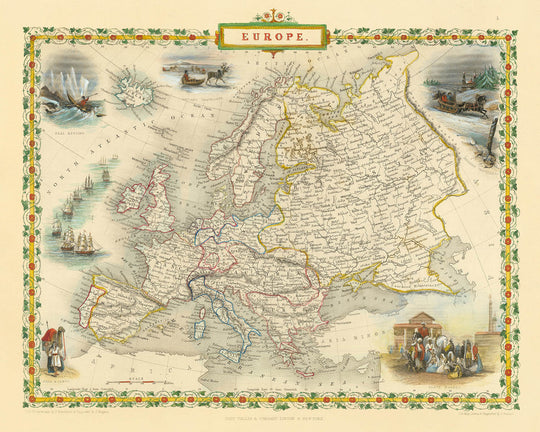
The model in the listing images is holding the 16x20in (40x50cm) version of this map.
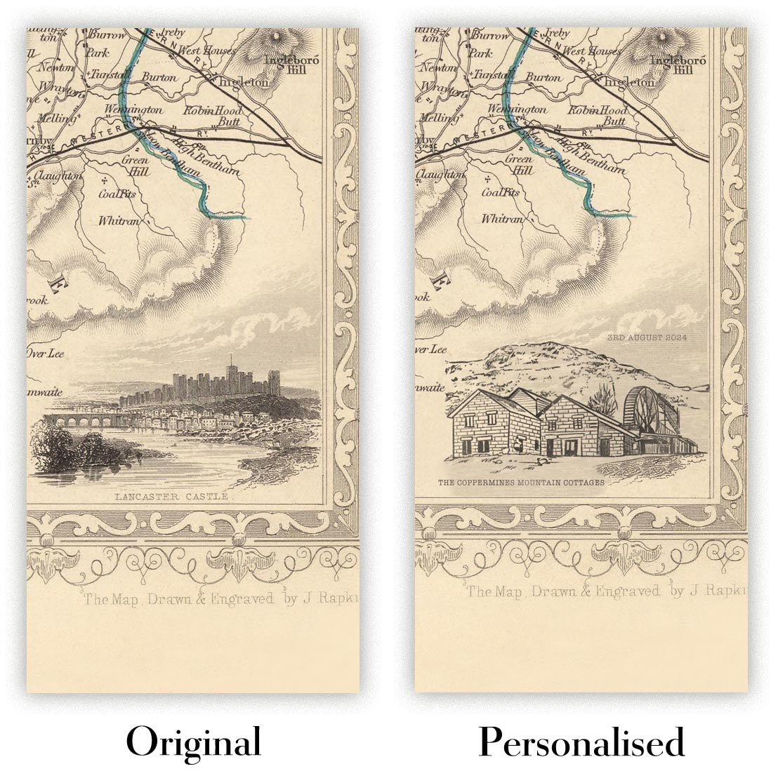
The fifth listing image shows an example of my map personalisation service.
If you’re looking for something slightly different, check out my collection of the best old maps to see if something else catches your eye.
Please contact me to check if a certain location, landmark or feature is shown on this map.
This would make a wonderful birthday, Christmas, Father's Day, work leaving, anniversary or housewarming gift for someone from the areas covered by this map.
This map is available as a giclée print on acid free archival matte paper, or you can buy it framed. The frame is a nice, simple black frame that suits most aesthetics. Please get in touch if you'd like a different frame colour or material. My frames are glazed with super-clear museum-grade acrylic (perspex/acrylite), which is significantly less reflective than glass, safer, and will always arrive in perfect condition.
This map is also available as a float framed canvas, sometimes known as a shadow gap framed canvas or canvas floater. The map is printed on artist's cotton canvas and then stretched over a handmade box frame. We then "float" the canvas inside a wooden frame, which is available in a range of colours (black, dark brown, oak, antique gold and white). This is a wonderful way to present a map without glazing in front. See some examples of float framed canvas maps and explore the differences between my different finishes.
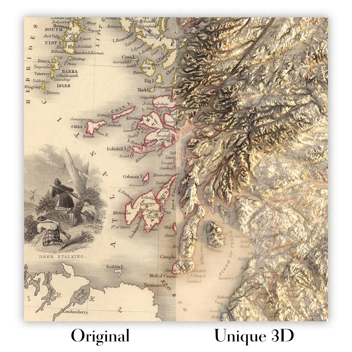
For something truly unique, this map is also available in "Unique 3D", our trademarked process that dramatically transforms the map so that it has a wonderful sense of depth. We combine the original map with detailed topography and elevation data, so that mountains and the terrain really "pop". For more info and examples of 3D maps, check my Unique 3D page.
For most orders, delivery time is about 3 working days. Personalised and customised products take longer, as I have to do the personalisation and send it to you for approval, which usually takes 1 or 2 days.
Please note that very large framed orders usually take longer to make and deliver.
If you need your order to arrive by a certain date, please contact me before you order so that we can find the best way of making sure you get your order in time.
I print and frame maps and artwork in 23 countries around the world. This means your order will be made locally, which cuts down on delivery time and ensures that it won't be damaged during delivery. You'll never pay customs or import duty, and we'll put less CO2 into the air.
All of my maps and art prints are well packaged and sent in a rugged tube if unframed, or surrounded by foam if framed.
I try to send out all orders within 1 or 2 days of receiving your order, though some products (like face masks, mugs and tote bags) can take longer to make.
If you select Express Delivery at checkout your order we will prioritise your order and send it out by 1-day courier (Fedex, DHL, UPS, Parcelforce).
Next Day delivery is also available in some countries (US, UK, Singapore, UAE) but please try to order early in the day so that we can get it sent out on time.
My standard frame is a gallery style black ash hardwood frame. It is simple and quite modern looking. My standard frame is around 20mm (0.8in) wide.
I use super-clear acrylic (perspex/acrylite) for the frame glass. It's lighter and safer than glass - and it looks better, as the reflectivity is lower.
Six standard frame colours are available for free (black, dark brown, dark grey, oak, white and antique gold). Custom framing and mounting/matting is available if you're looking for something else.
Most maps, art and illustrations are also available as a framed canvas. We use matte (not shiny) cotton canvas, stretch it over a sustainably sourced box wood frame, and then 'float' the piece within a wood frame. The end result is quite beautiful, and there's no glazing to get in the way.
All frames are provided "ready to hang", with either a string or brackets on the back. Very large frames will have heavy duty hanging plates and/or a mounting baton. If you have any questions, please get in touch.
See some examples of my framed maps and framed canvas maps.
Alternatively, I can also supply old maps and artwork on canvas, foam board, cotton rag and other materials.
If you want to frame your map or artwork yourself, please read my size guide first.
My maps are extremely high quality reproductions of original maps.
I source original, rare maps from libraries, auction houses and private collections around the world, restore them at my London workshop, and then use specialist giclée inks and printers to create beautiful maps that look even better than the original.
My maps are printed on acid-free archival matte (not glossy) paper that feels very high quality and almost like card. In technical terms the paper weight/thickness is 10mil/200gsm. It's perfect for framing.
I print with Epson ultrachrome giclée UV fade resistant pigment inks - some of the best inks you can find.
I can also make maps on canvas, cotton rag and other exotic materials.
Learn more about The Unique Maps Co.
Map personalisation
If you're looking for the perfect anniversary or housewarming gift, I can personalise your map to make it truly unique. For example, I can add a short message, or highlight an important location, or add your family's coat of arms.
The options are almost infinite. Please see my map personalisation page for some wonderful examples of what's possible.
To order a personalised map, select "personalise your map" before adding it to your basket.
Get in touch if you're looking for more complex customisations and personalisations.
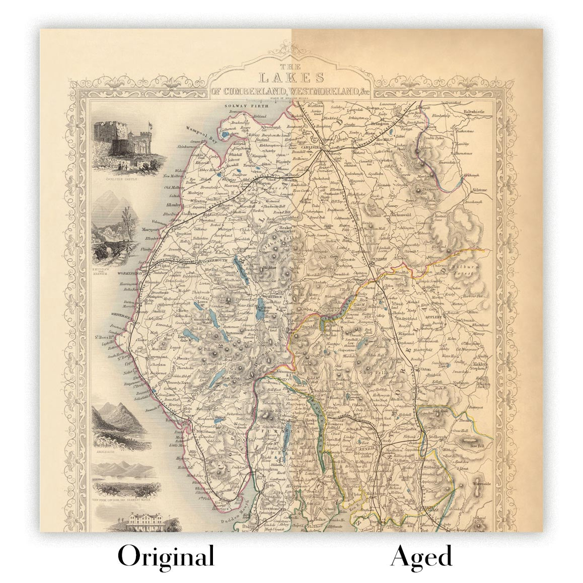
Map ageing
I have been asked hundreds of times over the years by customers if they could buy a map that looks even older.
Well, now you can, by selecting Aged before you add a map to your basket.
All the product photos you see on this page show the map in its Original form. This is what the map looks like today.
If you select Aged, I will age your map by hand, using a special and unique process developed through years of studying old maps, talking to researchers to understand the chemistry of aging paper, and of course... lots of practice!
If you're unsure, stick to the Original colour of the map. If you want something a bit darker and older looking, go for Aged.
If you are not happy with your order for any reason, contact me and I'll get it fixed ASAP, free of charge. Please see my returns and refund policy for more information.
I am very confident you will like your restored map or art print. I have been doing this since 1984. I'm a 5-star Etsy seller. I have sold tens of thousands of maps and art prints and have over 5,000 real 5-star reviews. My work has been featured in interior design magazines, on the BBC, and on the walls of dozens of 5-star hotels.
I use a unique process to restore maps and artwork that is massively time consuming and labour intensive. Hunting down the original maps and illustrations can take months. I use state of the art and eye-wateringly expensive technology to scan and restore them. As a result, I guarantee my maps and art prints are a cut above the rest. I stand by my products and will always make sure you're 100% happy with what you receive.
Almost all of my maps and art prints look amazing at large sizes (200cm, 6.5ft+) and I can frame and deliver them to you as well, via special oversized courier. Contact me to discuss your specific needs.
Or try searching for something!


