


Alte bildliche Karte der Luftstraße San Francisco–Los Angeles, 1929: Yosemite, Lake Tahoe, Monterey Bay, Grapevine Pass, Central Valley
20% Rabatt auf 2 — 33% Rabatt auf 3
Fügen Sie beliebige zwei berechtigte Artikel zu Ihrem Warenkorb hinzu, um 20% Rabatt zu erhalten. Fügen Sie einen dritten hinzu und er ist kostenlos (entspricht 33% Rabatt, wenn Sie drei kaufen).
Kein Code erforderlich — das Angebot wird automatisch an der Kasse angewendet.
Gültig für alle Standardkarten und Kunstdrucke. Sie können beliebige Designs kombinieren.
Wenn Sie Artikel an mehrere Adressen versenden möchten, kontaktieren Sie uns bitte, bevor Sie Ihre Bestellung aufgeben.
Maßanfertigungen und individuelle Aufträge sind ausgeschlossen.
Kontaktieren Sie uns wenn Sie Fragen haben
-
![]() Made to order locally in Canada
Made to order locally in Canada

-
Free delivery &
usually dispatched next day
Dispatched next working day
Your map should be dispatched the next working day.
Express delivery is available at checkout.
If you need your order to arrive by a certain date, contact me and we can discuss your options.
Please note that personalised maps, and some larger framed maps can take longer to produce and deliver.
-
Complimentary gifting & design advice
ⓘ
Complimentary gifting & design advice
Available almost 24/7 on WhatsApp and email — we usually reply within minutes. We can help you:
- Choose a perfectly personalised gift
- Send a digital gift preview to the recipient
- Pick the ideal size for your wall
- Select the right finish and frame
Quick, friendly advice so you can order with confidence.
For last minute gifts, consider buying a digital gift card. We have over 5,000 maps and art prints to choose from.
-
90-day returns & 5-year guarantee
ⓘ
90 Tage für Rückgabe und Rückerstattung
Produkte können innerhalb von 90 Tagen für eine vollständige Rückerstattung oder einen Umtausch gegen ein anderes Produkt zurückgegeben werden.
Für personalisierte und maßgefertigte Artikel können wir Ihnen möglicherweise einen Gutschein oder eine nicht ablaufende Geschenkkarte anbieten, da wir personalisierte Bestellungen nicht weiterverkaufen können.
Wenn Sie Fragen haben, kontaktieren Sie uns. Für weitere Informationen siehe unsere vollständige Rückgabe- und Umtauschrichtlinie.

This is a museum-grade archival print from the original 1929 map — restored in our workshop and made to order on 220gsm archival matte paper or 400gsm artist's cotton canvas with pigment inks.
Beautifully framed and ready to hang, with complimentary personalisation available.
Choose your size
Choose your frame


Geschenkmitteilung & individuelle Ausführung

Wenn Sie eine Geschenkmitteilung oder eine Ausführung (Puzzle, Aluminiumplatte usw.) hinzufügen möchten, die hier nicht verfügbar ist, geben Sie dies bitte in der "Bestellnotiz" beim Checkout an.
Jede Bestellung wird individuell angefertigt. Wenn Sie die Größe leicht anpassen oder auf einem ungewöhnlichen Material drucken lassen möchten, lassen Sie es uns einfach wissen. Wir haben im Laufe der Jahre Tausende von individuellen Bestellungen bearbeitet, daher gibt es (fast) nichts, was wir nicht bewältigen können.
Sie können uns auch kontaktieren, bevor Sie bestellen, wenn Sie möchten!

- Handmade locally. No import duty or tax
- FREE worldwide delivery
- 90-day returns & 5-year product guarantee
- Questions? WhatsApp me any time
Own a piece of history
7,000+ 5 star reviews


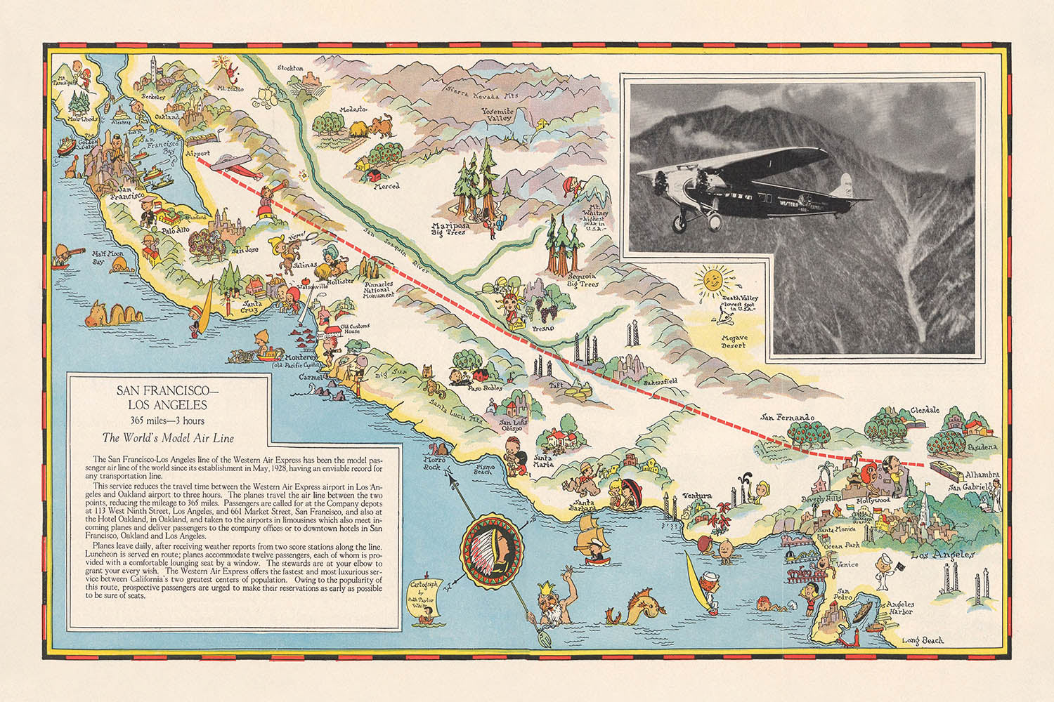
Betreten Sie das goldene Zeitalter der Luftfahrt mit dieser außergewöhnlichen, 1929 gestalteten Bildkarte, „San Francisco - Los Angeles“, die von der renommierten Kartografin Ruth Taylor White für Western Air Express sorgfältig erstellt wurde. Diese Karte ist weit mehr als nur ein einfaches Navigationswerkzeug; sie ist ein lebendiges Artefakt aus einer Ära, in der das Fliegen ein Symbol für Fortschritt und Modernität war. Mit einer markanten Route, die San Francisco und Los Angeles verbindet, fängt die Karte die Aufregung und das Versprechen ein, Kaliforniens malerisches Herzland in nur drei Stunden zu durchqueren – eine Leistung, die zur damaligen Zeit den Geist von Innovation und Abenteuer verkörperte.
Ruth Taylor Whites Kunstfertigkeit strahlt in jedem Detail aus und verbindet lebendige Illustrationen mit präzisen kartografischen Elementen. Die Karte zeigt nicht nur die großen urbanen Zentren von San Francisco und Los Angeles, sondern auch ein Wandteppich der am meisten geschätzten Landschaften Kaliforniens: das üppige Central Valley, die majestätischen Sierra Nevada und die ikonische pazifische Küste. Jede Vignette ist durchdacht gestaltet und zeigt landwirtschaftliche Fülle, pulsierende Städte und ruhige Wälder und bietet eine visuelle Erzählung über die wirtschaftlichen und natürlichen Reichtümer des Staates in den späten 1920er Jahren.
Historisch gesehen steht diese Karte als Zeugnis für die transformative Kraft der frühen kommerziellen Luftfahrt. Western Air Express, eine der Pionierfluggesellschaften der Vereinigten Staaten, nutzte diese Karte sowohl als Werbung als auch zur Feier der neuen Möglichkeiten, die das Fliegen für den amerikanischen Westen brachte. Die Einbeziehung von Freizeitaktivitäten – wie Skifahren, Golf und Strandausflüge – neben industriellen und landwirtschaftlichen Szenen hebt Kaliforniens doppelte Identität als Land der Möglichkeiten und als Spielplatz für Freizeit und Tourismus hervor. Die werbliche Botschaft der Karte spiegelt den Optimismus einer Ära wider, in der der Himmel nicht mehr die Grenze war.
Über ihre visuelle Anziehungskraft hinaus ist die Karte reich an historischem Kontext. Sie dokumentiert eine Zeit, in der Kaliforniens Städte blühten, seine landwirtschaftlichen Täler die Nation ernährten und seine Naturwunder für ein breiteres Publikum zugänglich wurden. Die sorgfältige Beschriftung der wichtigsten Standorte auf der Karte – Yosemite Nationalpark, Lake Tahoe, Monterey Bay und der Grapevine Pass – dient als Führer zu den bedeutendsten Orten der Region, von denen viele eine entscheidende Rolle in der Entwicklung des Staates gespielt haben. Die illustrierte Luftroute selbst zeichnet einen Korridor nach, der einer der verkehrsreichsten und wichtigsten in der Geschichte der amerikanischen Luftfahrt werden sollte.
Diese Karte zu besitzen, ist vergleichbar mit dem Besitz eines Fensters zu einem entscheidenden Moment in Kaliforniens – und Amerikas – Geschichte. Sie ist eine Feier des Fortschritts, der Kunstfertigkeit und der grenzenlosen Neugier, die das frühe 20. Jahrhundert prägten. Egal, ob Sie ein Sammler feiner Karten, ein Liebhaber der Luftfahrtgeschichte oder ein Bewunderer von Kaliforniens geschichtsträchtiger Vergangenheit sind, dieses Stück bietet eine einzigartige Mischung aus historischem Einblick und visueller Freude und macht es zu einer herausragenden Ergänzung jeder kuratierten Sammlung.
Orte auf dieser Karte
- San Francisco
- Los Angeles
- San Jose
- Oakland
- Stockton
- Fresno
- Bakersfield
- Santa Barbara
- Monterey Bay
- Salinas Valley
- San Luis Obispo
- Santa Cruz
- Ventura
- Riverside
- Pasadena
- Lake Tahoe
- Yosemite Nationalpark
- Grapevine Pass
- Tehachapi Mountains
- Sacramento River
Bemerkenswerte Merkmale & Wahrzeichen
- Die Luftroute zwischen San Francisco und Los Angeles, prominent illustriert
- Der Pazifische Ozean, beschriftet und illustriert entlang der linken Kante der Karte
- Die Sierra Nevada Gebirgskette, bildlich dargestellt
- Das Central Valley, gezeigt mit landwirtschaftlichen Vignetten (Höhlen, Obstgärten, Pflanzen)
- Freizeitaktivitäten: Illustrationen von Skifahren, Golf und anderen Sportarten
- Industrielle und landwirtschaftliche Szenen: Ölfelder, Obstgärten, Weinberge und Viehzüchter
- Flüsse: Mehrere Flüsse sind illustriert und beschriftet, einschließlich der Sacramento- und San Joaquin-Flüsse
- Bergpässe und -ketten: Grapevine Pass, Tehachapi Mountains und andere sind illustriert
- Küstenmerkmale: Strände, Klippen und Buchten sind entlang der Route dargestellt
- Flugzeugillustrationen: Mehrere Flugzeuge sind zu sehen, die entlang der Route fliegen
- Vignetten des lokalen Lebens: Darstellungen von Menschen, die sich mit Landwirtschaft, Freizeit und täglichen Aktivitäten beschäftigen
- Wälder und Parks: Bildliche Darstellungen von Wäldern und Parklandschaften entlang der Route
- Entfernungen und Reisezeiten: Die Gesamtdistanz (365 Meilen) und Reisezeit (3 Stunden) sind vermerkt
Historischer und gestalterischer Kontext
- Erstellt im Oktober 1929 von Ruth Taylor White für Western Air Express, eine Pionierfluggesellschaft in den USA
- Produziert als doppelseitige bildliche Karte zur Werbung und Information über die Flugroute zwischen San Francisco und Los Angeles
- Spiegelt den Optimismus und die Innovation der frühen Luftfahrtära wider, als das Fliegen zugänglicher wurde
- Kombiniert informative Kartierung mit künstlerischer Illustration, typisch für den charakteristischen Stil von Ruth Taylor White
- Dient sowohl als Navigationshilfe als auch als Werbemittel für Western Air Express
- Verwendet bildliches Relief, um Berge und Gelände darzustellen, was das visuelle Interesse und die Klarheit der Karte erhöht
- Hebt Freizeitmöglichkeiten und wirtschaftliche Aktivitäten entlang der Route hervor, wie Landwirtschaft, Sport und Tourismus
- Fängt den Geist Kaliforniens in den späten 1920er Jahren ein, mit seiner Mischung aus städtischen Zentren, landwirtschaftlichen Regionen und malerischen Landschaften
- Stellt eine Mischung aus Tourismus, kommerzieller Werbung und kartografischer Kunst aus der Zwischenkriegszeit dar
- Karten wie diese trugen zur Popularisierung des Luftverkehrs und zur Romantisierung Kaliforniens als Reiseziel bei
Bitte überprüfen Sie die Bilder, um sicherzustellen, dass eine bestimmte Stadt oder ein Ort auf dieser Karte gezeigt wird. Sie können uns auch kontaktieren und bitten, die Karte für Sie zu überprüfen.
Diese Karte sieht in jeder Größe großartig aus, aber ich empfehle immer, eine größere Größe zu wählen, wenn Sie Platz haben. So können Sie alle Details leicht erkennen.
Diese Karte sieht bis zu 70 Zoll (180 cm) fantastisch aus. Wenn Sie nach einer größeren Karte suchen, bitte kontaktieren Sie uns.
Das Modell auf den Listing-Bildern hält die 24x36 Zoll (60x90 cm) Version dieser Karte.
Das fünfte Listing-Bild zeigt ein Beispiel für meinen Personalisierungsservice für Karten.
Wenn Sie nach etwas leicht anderem suchen, schauen Sie sich meine Sammlung der besten alten Karten an, um zu sehen, ob etwas anderes Ihr Interesse weckt.
Bitte kontaktieren Sie mich, um zu prüfen, ob ein bestimmter Ort, Wahrzeichen oder ein Merkmal auf dieser Karte gezeigt wird.
Das wäre ein wunderbares Geburtstags-, Weihnachts-, Vatertags-, Abschieds-, Jubiläums- oder Einweihungsgeschenk für jemanden aus den Gebieten, die von dieser Karte abgedeckt werden.
This map is also available as a float framed canvas, sometimes known as a shadow gap framed canvas or canvas floater. The map is printed on artist's cotton canvas and then stretched over a handmade box frame. We then "float" the canvas inside a wooden frame, which is available in a range of colours (black, dark brown, oak, antique gold and white). This is a wonderful way to present a map without glazing in front. See some examples of float framed canvas maps and explore the differences between my different finishes.
For something truly unique, this map is also available in "Unique 3D", our trademarked process that dramatically transforms the map so that it has a wonderful sense of depth. We combine the original map with detailed topography and elevation data, so that mountains and the terrain really "pop". For more info and examples of 3D maps, check my Unique 3D page.
Für die meisten Bestellungen beträgt die Lieferzeit etwa 3 Werktage. Personalisierte und maßgeschneiderte Produkte benötigen länger, da ich die Personalisierung durchführen und sie Ihnen zur Genehmigung zusenden muss, was normalerweise 1 oder 2 Tage dauert.
Bitte beachten Sie, dass sehr große gerahmte Bestellungen in der Regel länger für die Herstellung und Lieferung benötigen.
Wenn Sie möchten, dass Ihre Bestellung bis zu einem bestimmten Datum ankommt, bitte kontaktieren Sie mich, bevor Sie bestellen, damit wir den besten Weg finden können, um sicherzustellen, dass Sie Ihre Bestellung rechtzeitig erhalten.
Ich drucke und rahme Karten und Kunstwerke in 23 Ländern weltweit. Das bedeutet, dass Ihre Bestellung lokal gefertigt wird, was die Lieferzeit verkürzt und sicherstellt, dass sie während der Lieferung nicht beschädigt wird. Sie zahlen nie Zoll oder Einfuhrgebühren, und wir stoßen weniger CO2 in die Luft aus.
Alle meine Karten und Kunstdrucke sind gut verpackt und werden in einem robusten Rohr versendet, wenn sie ungerahmt sind, oder von Schaum umgeben, wenn sie gerahmt sind.
Ich versuche, alle Bestellungen innerhalb von 1 oder 2 Tagen nach Erhalt Ihrer Bestellung zu versenden, obwohl einige Produkte (wie Gesichtsmasken, Tassen und Tragetaschen) länger zur Herstellung benötigen können.
Wenn Sie Express-Lieferung an der Kasse auswählen, priorisieren wir Ihre Bestellung und versenden sie per 1-Tages-Kurier (Fedex, DHL, UPS, Parcelforce).
Nächster Tag Lieferung ist auch in einigen Ländern verfügbar (USA, UK, Singapur, VAE), aber bitte versuchen Sie, früh am Tag zu bestellen, damit wir es rechtzeitig versenden können.
Lesen Sie meinen vollständigen Leitfaden zur Lieferung und lokalen Produktion
Mein Standardrahmen ist ein Galerie-Stil-Rahmen aus schwarzem Eschenholz. Er ist einfach und sieht ziemlich modern aus. Mein Standardrahmen ist etwa 20 mm (0,8 Zoll) breit.
Ich verwende super-klares Acryl (Plexiglas/Acrylt) für das Glas des Rahmens. Es ist leichter und sicherer als Glas – und es sieht besser aus, da die Reflexion geringer ist.
Sechs Standardrahmenfarben sind kostenlos erhältlich (schwarz, dunkelbraun, dunkelgrau, Eiche, weiß und antikgold).
Die meisten Karten, Kunstwerke und Illustrationen sind auch als gerahmte Leinwand erhältlich. Wir verwenden matte (nicht glänzende) Baumwollleinwand, spannen sie über einen nachhaltig beschafften Buchenrahmen und 'schweben' dann das Stück innerhalb eines Holzrahmens. Das Endergebnis ist ziemlich schön, und es gibt keine Verglasung, die im Weg ist.
Alle Rahmen werden "bereit zum Aufhängen" geliefert, entweder mit einer Schnur oder Halterungen auf der Rückseite. Sehr große Rahmen haben schwere Aufhängeplatten und/oder eine Montageschiene. Wenn Sie Fragen haben, können Sie bitte Kontakt aufnehmen.
Sehen Sie sich einige Beispiele meiner gerahmten Karten und gerahmten Leinwandkarten an.
Alternativ kann ich auch alte Karten und Kunstwerke auf Leinwand, Schaumstoffplatten, Baumwollrag und andere Materialien liefern.
Wenn Sie Ihre Karte oder Ihr Kunstwerk selbst rahmen möchten, lesen Sie bitte zuerst meinen Größenleitfaden.
Meine Karten sind äußerst hochwertige Reproduktionen von Originalkarten.
Ich beziehe originale, seltene Karten aus Bibliotheken, Auktionshäusern und Privatsammlungen auf der ganzen Welt, restauriere sie in meiner Londoner Werkstatt und erstelle dann mit speziellen Giclée-Tinten und -Druckern wunderschöne Karten, die sogar noch besser aussehen als das Original.
Meine Karten werden auf säurefreiem, mattem Archivpapier (nicht glänzend) gedruckt, das sich sehr hochwertig anfühlt und fast wie Karton aussieht. Technisch gesehen beträgt das Papiergewicht/die Papierdicke 10mil/200g/m². Es eignet sich perfekt zum Einrahmen.
Ich drucke mit UV-lichtbeständigen Ultrachrome-Giclée-Pigmenttinten von Epson – einige der besten Tinten, die Sie finden können.
Ich kann auch machen Karten auf Leinwand, Baumwolllappen und andere exotische Materialien.
Erfahren Sie mehr über The Unique Maps Co.
Kartenpersonalisierung
Wenn Sie nach dem perfekten Geschenk zum Jahrestag oder zur Einweihung suchen, kann ich Ihre Karte personalisieren, um sie wirklich einzigartig zu machen. Ich kann beispielsweise eine kurze Nachricht hinzufügen, einen wichtigen Ort hervorheben oder das Wappen Ihrer Familie hinzufügen.
Die Möglichkeiten sind nahezu unbegrenzt. Bitte sehen Sie sich meine Kartenpersonalisierungsseite für einige wunderbare Beispiele dessen, was möglich ist.
Um eine personalisierte Karte zu bestellen, wählen Sie „Personalisieren Sie Ihre Karte“, bevor Sie sie in den Warenkorb legen.
In Kontakt kommen wenn Sie nach komplexeren Anpassungen und Personalisierungen suchen.
Kartenalterung
Im Laufe der Jahre wurde ich von Kunden hunderte Male gefragt, ob sie eine Karte kaufen könnten, die noch älter.
Nun, jetzt können Sie das, indem Sie „Alter“ auswählen, bevor Sie eine Karte in Ihren Warenkorb legen.
Alle Produktfotos, die Sie auf dieser Seite sehen, zeigen die Karte in ihrer Originalform. So sieht die Karte heute aus.
Wenn Sie „Gealtert“ auswählen, werde ich Ihre Karte von Hand altern lassen. Dazu verwende ich ein spezielles und einzigartiges Verfahren, das ich durch jahrelanges Studium alter Karten und Gespräche mit Forschern zum Verständnis der Chemie alternder Papiere entwickelt habe, und natürlich ... viel Übung!
Wenn Sie sich nicht sicher sind, bleiben Sie bei der Originalfarbe der Karte. Wenn Sie etwas Dunkleres und älter Wenn Sie auf der Suche sind, entscheiden Sie sich für „Aged“.
Sehen Sie einige erstaunliche Beispiele für gealterte Karten.
Wenn Sie aus irgendeinem Grund mit Ihrer Bestellung nicht zufrieden sind, kontaktieren Sie mich für eine unkomplizierte Rückerstattung. Bitte sehen Sie sich unsere Rückgabe- und Rückerstattungsrichtlinien für weitere Informationen an.
Ich bin sehr zuversichtlich, dass Ihnen Ihre restaurierte Karte oder Kunstdruck gefallen wird. Ich mache das seit 1984. Ich bin ein 5-Sterne Etsy-Verkäufer. Ich habe Zehntausende von Karten und Kunstdrucken verkauft und habe über 5.000 echte 5-Sterne-Bewertungen.
Ich verwende einen einzigartigen Prozess, um Karten und Kunstwerke zu restaurieren, der extrem zeitaufwendig und arbeitsintensiv ist. Die Suche nach den Originalkarten und Illustrationen kann Monate dauern. Ich benutze modernste und unglaublich teure Technologie, um sie zu scannen und wiederherzustellen. Daher garantiere ich, dass meine Karten und Kunstdrucke eine Klasse für sich sind - deshalb kann ich eine unkomplizierte Rückerstattung anbieten.
Fast alle meine Karten und Kunstdrucke sehen in großen Größen (200 cm, 6,5 Fuß+) erstaunlich aus und ich kann sie Ihnen auch gerahmt und über einen speziellen Übergrößen-Kurier liefern. Kontaktieren Sie mich, um Ihre speziellen Bedürfnisse zu besprechen.
Or try searching for something!


