

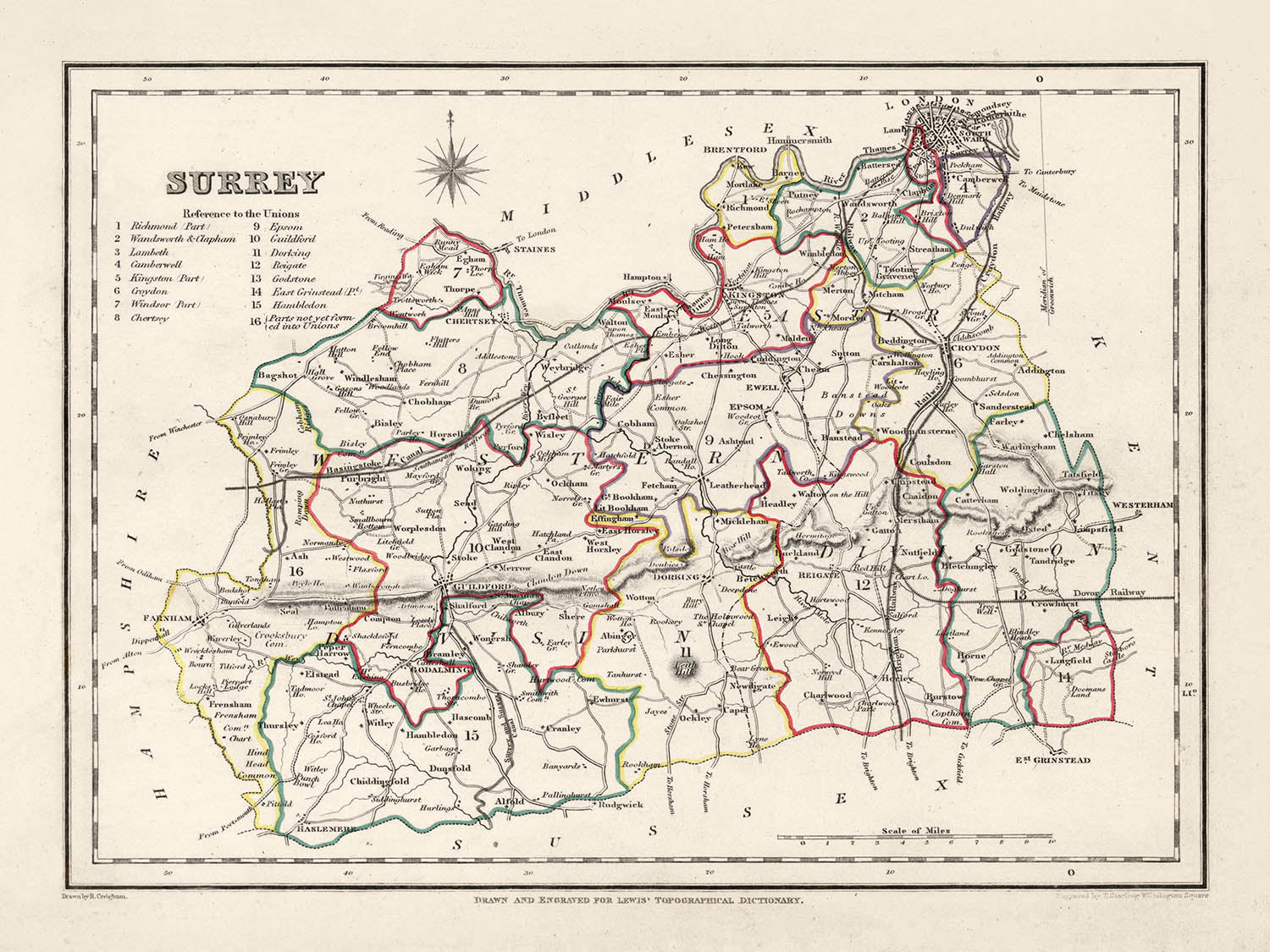
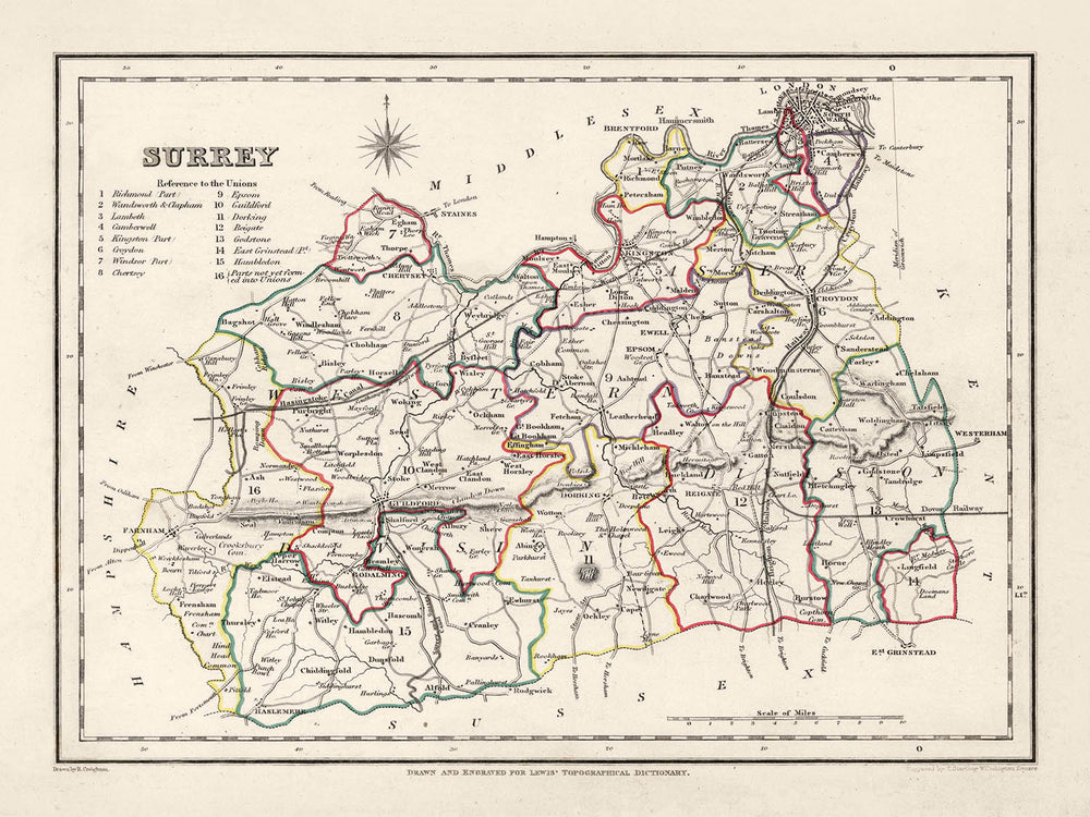


Alte Karte von Surrey von Samuel Lewis, 1844: London, Guildford, Woking, Ewell und Camberley
Kaufe 2, Erhalte 1 Kostenlos
Wenn Sie 2 Artikel in Ihren Warenkorb legen, können Sie ein drittes Produkt kostenlos hinzufügen.
Dies gilt für alle Karten und Kunstwerke, einschließlich individuell gestalteter und personalisierter Stücke. Sie können 3 von derselben Sache oder 3 verschiedene Dinge bestellen.
Das entspricht einem Rabatt von 33 %, der in diesem Jahr der größte Rabatt in meinem Shop sein wird.
Bitte nutzen Sie das Angebot und dekorieren Sie Ihre Wände mit schönen Karten und Kunst!
Kontaktieren Sie mich, wenn Sie Fragen haben.

-
![]() Handmade in Canada
Handmade in Canada
-
Free delivery &
usually dispatched next day
Dispatched next working day
Your map should be dispatched the next working day.
Deliveries over the Christmas and New Year period may be slightly delayed, as couriers and postal services catch up with a huge backlog of packages.
Express delivery is available at checkout.
If you need your order to arrive by a certain date, contact me and we can discuss your options.
Please note that personalised maps, and some larger framed maps can take longer to produce and deliver.
-
FREE gift preview
ⓘ
Digital gift preview
After you complete your order, you can send a beautiful digital preview to the gift recipient. Just provide their email address and we'll do the rest. (Their email address will not be stored or used for any other purpose.)
This is perfect if you're concerned that your order might not arrive in time.
You can also buy a real non-expiring gift card, and email it directly to the recipient, so they can buy their own map or artwork.
-
90 day money back guarantee
ⓘ
90 Tage für Rückgabe und Rückerstattung
Produkte können innerhalb von 90 Tagen für eine vollständige Rückerstattung oder einen Umtausch gegen ein anderes Produkt zurückgegeben werden.
Für personalisierte und maßgefertigte Artikel können wir Ihnen möglicherweise einen Gutschein oder eine nicht ablaufende Geschenkkarte anbieten, da wir personalisierte Bestellungen nicht weiterverkaufen können.
Wenn Sie Fragen haben, kontaktieren Sie uns. Für weitere Informationen siehe unsere vollständige Rückgabe- und Umtauschrichtlinie.

My maps are rare, museum-grade, restored old maps sourced from libraries, auction houses and private collections across the globe.
Framing & free personalisation available
1. Select your size
Click here to order a custom size.
2. Frame & personalise your map
Make your map unique with framing, hand-drawn customisation, vintage ageing, pop art text, unique 3D styling and more.


Geschenkmitteilung & individuelle Ausführung

Wenn Sie eine Geschenkmitteilung oder eine Ausführung (Puzzle, Aluminiumplatte usw.) hinzufügen möchten, die hier nicht verfügbar ist, geben Sie dies bitte in der "Bestellnotiz" beim Checkout an.
Jede Bestellung wird individuell angefertigt. Wenn Sie die Größe leicht anpassen oder auf einem ungewöhnlichen Material drucken lassen möchten, lassen Sie es uns einfach wissen. Wir haben im Laufe der Jahre Tausende von individuellen Bestellungen bearbeitet, daher gibt es (fast) nichts, was wir nicht bewältigen können.
Sie können uns auch kontaktieren, bevor Sie bestellen, wenn Sie möchten!

- Handmade locally. No import duty or tax
- FREE worldwide delivery
- Love it or your money back (90 days)
- Questions? WhatsApp me any time
Own a piece of history
5,000+ 5 star reviews


Umarmen Sie ein Stück historischer Kartografie mit dieser auffälligen Karte von Surrey aus dem Jahr 1844 von Samuel Lewis. Dieses visuell fesselnde Kunstwerk ist mehr als nur ein historisches Relikt; es ist ein Portal in die Vergangenheit, das es uns ermöglicht, die Entwicklung einiger der beliebtesten Städte, Dörfer und Siedlungen Englands nachzuvollziehen, die bereits zur Zeit der Erstellung dieser Karte in der Geschichte verwurzelt waren.
Durchdrungen von reicher Geschichte kann die Vergangenheit von Surrey faszinierend durch seine Siedlungen nachverfolgt werden. Diese Karte von 1844 umfasst Orte, die vor 1840 blühten, von denen einige sich erheblich verändert oder sogar ihren Namen geändert haben. Umgekehrt könnte es sein, dass einige moderne Siedlungen, die noch gegründet oder anerkannt werden sollten, fehlen. Dies schafft eine aufregende Gelegenheit für historische Entdeckungen und Vergleiche.
Siedlungen
(in der Reihenfolge der modernen Bevölkerungsgröße):- London (43 n. Chr.): Von den Römern als Londinium gegründet, war es eine wichtige Handelsstadt und die Provinzhauptstadt.
- Guildford (ca. 970 n. Chr.): Heimat einer königlichen Münze von der Herrschaft König Alfreds bis zur Zeit Wilhelm des Eroberers.
- Woking (ca. 1086 n. Chr.): Im Domesday Book als Wochinges vermerkt, gehörte es König Wilhelm.
- Ewell (vor 775 n. Chr.): Bekannt für seine römischen Überreste, einschließlich einer Villa und eines Badehauses.
- Camberley (ca. 1200 n. Chr.): Historisch Teil eines Gebiets, das als Bagshot Heath bekannt ist, berühmt für Straßenräuber im 17. Jahrhundert.
- Redhill (ca. 1818 n. Chr.): Ursprünglich ein Rastplatz auf der Straße von London nach Brighton im 18. Jahrhundert.
- Reigate (ca. 1088 n. Chr.): Heimat von Reigate Castle, das kurz nach der normannischen Eroberung gegründet wurde.
- Staines-upon-Thames (ca. 100 n. Chr.): Eine historische Marktstadt, die einst der Standort einer römischen Brücke war.
- Sunbury-on-Thames (vor 962 n. Chr.): Im angelsächsischen Chronicle erwähnt, bekannt für seine Lage am Fluss.
- Banstead (vor 1086 n. Chr.): Bekannt für seine Geschichte in der Landwirtschaft, im Domesday Book erwähnt.
- Epsom (vor 1086 n. Chr.): Die Heimat von Epsom-Salz und dem Epsom Derby.
- Farnham (ca. 688 n. Chr.): Bekannt für seine georgianische Straßenansicht und einen alten Wildpark.
- Dorking (ca. 1086 n. Chr.): Heimat der Dorking Halls, einem wichtigen Veranstaltungsort für Konzerte und Filme.
- Chertsey (ca. 666 n. Chr.): Bekannt für sein Kloster, das eines der größten Benediktinerklöster in England war.
- Godalming (ca. 880 n. Chr.): Wurde 1881 zur ersten Stadt der Welt mit einer öffentlichen Stromversorgung.
- Haslemere (vor 1221 n. Chr.): Bekannt für sein "georgianisches und früheres" Stadtzentrum.
- Caterham (vor 1086 n. Chr.): Im Domesday Book erwähnt und die Heimat des Herstellers Caterham Cars.
- Leatherhead (vor 880 n. Chr.): Ein bedeutender Kreuzungspunkt auf der Hauptstraße von London zur Südküste.
- Esher (vor 1086 n. Chr.): Heimat des Claremont Landscape Garden, einer bemerkenswerten National Trust-Eigenschaft.
- Cobham (vor 1086 n. Chr.): Bekannt für seine historischen Gebäude, einschließlich der Cobham Mill, einer Wassermühle von 1822.
- Walton-on-Thames (vor 1086 n. Chr.): Standort eines römischen Forts, der "Statio Albani," an der Militärstraße nach London.
- East Molesey (vor 1086 n. Chr.): Heimat des Hampton Court Palace, der für Kardinal Thomas Wolsey im frühen 16. Jahrhundert erbaut wurde.
- Ashtead (vor 1086 n. Chr.): Bekannt für seine römische Villa und Ziegelfabriken, die in den 1920er und 1980er Jahren ausgegraben wurden.
Bemerkenswerte Merkmale:
- Der Fluss Thames, eine wichtige Wasserstraße in England, bekannt für seine Rolle im Handel, Transport und in der Freizeitgestaltung.
- Die North Downs, ein Höhenzug aus Kreidefelsen, Teil eines Gebiets von außergewöhnlicher natürlicher Schönheit (AONB).
- Box Hill, eine beliebte Touristenattraktion mit Panoramablick und seltener Wildtiere.
- Der Virginia Water See, gelegen im Windsor Great Park, beliebt für seine schönen Landschaften.
Historische Ereignisse (1800-1850):
- Der Bau der London-Southampton-Eisenbahn (1838), der zum schnellen Wachstum von Städten wie Woking führte.
- Die erste Durchführung des Epsom Derby, eines prestigeträchtigen Pferderennens, im Jahr 1780 (mit seiner kontinuierlichen Durchführung bis weit in den untersuchten Zeitraum).
Entdecken, erkunden und verlieben Sie sich in die bezaubernde Geschichte von Surrey durch diese bemerkenswerte Karte von 1844 von Samuel Lewis. Eine perfekte Mischung aus Geschichte, Kunst und Kultur, sie ist wirklich eine hervorragende Ergänzung für jede Sammlung oder ein tolles Geschenk für den leidenschaftlichen Geschichtsfreund.
Bitte überprüfen Sie die Bilder, um sicherzustellen, dass eine bestimmte Stadt oder ein Ort auf dieser Karte angezeigt wird. Sie können uns auch kontaktieren und bitten, die Karte für Sie zu überprüfen.
Diese Karte sieht in allen Größen großartig aus: 8x10 Zoll (20,5x25,5 cm), 12x16 Zoll (30,5x41 cm), 18x24 Zoll (45,5x61 cm), 16x20 Zoll (40,5x51 cm), 24x36 Zoll (61x91,5 cm), 30x40 Zoll (76x101,5 cm) und 37x50 Zoll (94x127 cm), aber sie sieht noch besser aus, wenn sie groß gedruckt wird.
Ich kann schöne, große Drucke dieser Karte bis zu 50 Zoll (127 cm) erstellen. Bitte kontaktieren Sie mich, wenn Sie nach größeren, maßgeschneiderten oder anderen Rahmenoptionen suchen.
Das Modell in den Bildanzeigen hält die 18x24 Zoll (45,5x61 cm) Version dieser Karte.
Das fünfte Bild in der Liste zeigt ein Beispiel für meinen Personalisierungsservice für Karten.
Wenn Sie nach etwas etwas anderem suchen, schauen Sie sich meine Haupt-Sammlung von Karten des Vereinigten Königreichs und Irlands an.
Bitte kontaktieren Sie mich, um zu überprüfen, ob ein bestimmter Standort, Wahrzeichen oder Merkmal auf dieser Karte angezeigt wird.
Dies wäre ein wunderbares Geschenk zum Geburtstag, Weihnachten, Vatertag, zur Verabschiedung von der Arbeit, zum Jubiläum oder zur Einweihung für jemanden aus den Gebieten, die von dieser Karte abgedeckt werden.
Diese Karte ist als Giclée-Druck auf säurefreiem, archiviertem mattem Papier erhältlich, oder Sie können sie gerahmt kaufen. Der Rahmen ist ein schöner, einfacher schwarzer Rahmen, der zu den meisten Ästhetiken passt. Bitte kontaktieren Sie mich, wenn Sie eine andere Rahmenfarbe oder -material wünschen. Meine Rahmen sind mit superklarem Museumsglas (Plexiglas/Acrylt) verglast, das deutlich weniger reflektierend ist als Glas, sicherer ist und immer in perfektem Zustand ankommt.
This map is also available as a float framed canvas, sometimes known as a shadow gap framed canvas or canvas floater. The map is printed on artist's cotton canvas and then stretched over a handmade box frame. We then "float" the canvas inside a wooden frame, which is available in a range of colours (black, dark brown, oak, antique gold and white). This is a wonderful way to present a map without glazing in front. See some examples of float framed canvas maps and explore the differences between my different finishes.
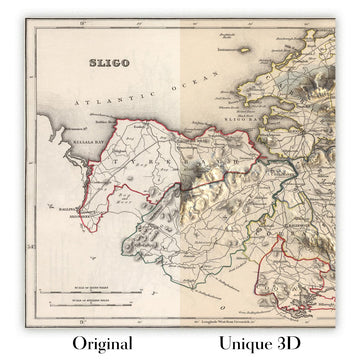
For something truly unique, this map is also available in "Unique 3D", our trademarked process that dramatically transforms the map so that it has a wonderful sense of depth. We combine the original map with detailed topography and elevation data, so that mountains and the terrain really "pop". For more info and examples of 3D maps, check my Unique 3D page.
Für die meisten Bestellungen beträgt die Lieferzeit etwa 3 Werktage. Personalisierte und maßgeschneiderte Produkte benötigen länger, da ich die Personalisierung durchführen und sie Ihnen zur Genehmigung zusenden muss, was normalerweise 1 oder 2 Tage dauert.
Bitte beachten Sie, dass sehr große gerahmte Bestellungen in der Regel länger für die Herstellung und Lieferung benötigen.
Wenn Sie möchten, dass Ihre Bestellung bis zu einem bestimmten Datum ankommt, bitte kontaktieren Sie mich, bevor Sie bestellen, damit wir den besten Weg finden können, um sicherzustellen, dass Sie Ihre Bestellung rechtzeitig erhalten.
Ich drucke und rahme Karten und Kunstwerke in 23 Ländern weltweit. Das bedeutet, dass Ihre Bestellung lokal gefertigt wird, was die Lieferzeit verkürzt und sicherstellt, dass sie während der Lieferung nicht beschädigt wird. Sie zahlen nie Zoll oder Einfuhrgebühren, und wir stoßen weniger CO2 in die Luft aus.
Alle meine Karten und Kunstdrucke sind gut verpackt und werden in einem robusten Rohr versendet, wenn sie ungerahmt sind, oder von Schaum umgeben, wenn sie gerahmt sind.
Ich versuche, alle Bestellungen innerhalb von 1 oder 2 Tagen nach Erhalt Ihrer Bestellung zu versenden, obwohl einige Produkte (wie Gesichtsmasken, Tassen und Tragetaschen) länger zur Herstellung benötigen können.
Wenn Sie Express-Lieferung an der Kasse auswählen, priorisieren wir Ihre Bestellung und versenden sie per 1-Tages-Kurier (Fedex, DHL, UPS, Parcelforce).
Nächster Tag Lieferung ist auch in einigen Ländern verfügbar (USA, UK, Singapur, VAE), aber bitte versuchen Sie, früh am Tag zu bestellen, damit wir es rechtzeitig versenden können.
Lesen Sie meinen vollständigen Leitfaden zur Lieferung und lokalen Produktion
Mein Standardrahmen ist ein Galerie-Stil-Rahmen aus schwarzem Eschenholz. Er ist einfach und sieht ziemlich modern aus. Mein Standardrahmen ist etwa 20 mm (0,8 Zoll) breit.
Ich verwende super-klares Acryl (Plexiglas/Acrylt) für das Glas des Rahmens. Es ist leichter und sicherer als Glas – und es sieht besser aus, da die Reflexion geringer ist.
Sechs Standardrahmenfarben sind kostenlos erhältlich (schwarz, dunkelbraun, dunkelgrau, Eiche, weiß und antikgold).
Die meisten Karten, Kunstwerke und Illustrationen sind auch als gerahmte Leinwand erhältlich. Wir verwenden matte (nicht glänzende) Baumwollleinwand, spannen sie über einen nachhaltig beschafften Buchenrahmen und 'schweben' dann das Stück innerhalb eines Holzrahmens. Das Endergebnis ist ziemlich schön, und es gibt keine Verglasung, die im Weg ist.
Alle Rahmen werden "bereit zum Aufhängen" geliefert, entweder mit einer Schnur oder Halterungen auf der Rückseite. Sehr große Rahmen haben schwere Aufhängeplatten und/oder eine Montageschiene. Wenn Sie Fragen haben, können Sie bitte Kontakt aufnehmen.
Sehen Sie sich einige Beispiele meiner gerahmten Karten und gerahmten Leinwandkarten an.
Alternativ kann ich auch alte Karten und Kunstwerke auf Leinwand, Schaumstoffplatten, Baumwollrag und andere Materialien liefern.
Wenn Sie Ihre Karte oder Ihr Kunstwerk selbst rahmen möchten, lesen Sie bitte zuerst meinen Größenleitfaden.
Einige meiner alten Karten sind jetzt als gerahmte Leinwände erhältlich. Bitte kontaktiere mich, wenn du eine Größe bestellen möchtest, die in meinem Shop nicht verfügbar ist.
Leinwand alte Karten sind eine interessante Alternative zu konventionell gerahmten Karten. Je nach deinem persönlichen Geschmack und der Raumdekoration können Leinwandkarten etwas mehr „herausstechen“ als eine gerahmte Karte.
Meine Karten sind äußerst hochwertige Reproduktionen von Originalkarten.
Ich beziehe originale, seltene Karten aus Bibliotheken, Auktionshäusern und Privatsammlungen auf der ganzen Welt, restauriere sie in meiner Londoner Werkstatt und erstelle dann mit speziellen Giclée-Tinten und -Druckern wunderschöne Karten, die sogar noch besser aussehen als das Original.
Meine Karten werden auf säurefreiem, mattem Archivpapier (nicht glänzend) gedruckt, das sich sehr hochwertig anfühlt und fast wie Karton aussieht. Technisch gesehen beträgt das Papiergewicht/die Papierdicke 10mil/200g/m². Es eignet sich perfekt zum Einrahmen.
Ich drucke mit UV-lichtbeständigen Ultrachrome-Giclée-Pigmenttinten von Epson – einige der besten Tinten, die Sie finden können.
Ich kann auch machen Karten auf Leinwand, Baumwolllappen und andere exotische Materialien.
Erfahren Sie mehr über The Unique Maps Co.
Kartenpersonalisierung
Wenn Sie nach dem perfekten Geschenk zum Jahrestag oder zur Einweihung suchen, kann ich Ihre Karte personalisieren, um sie wirklich einzigartig zu machen. Ich kann beispielsweise eine kurze Nachricht hinzufügen, einen wichtigen Ort hervorheben oder das Wappen Ihrer Familie hinzufügen.
Die Möglichkeiten sind nahezu unbegrenzt. Bitte sehen Sie sich meine Kartenpersonalisierungsseite für einige wunderbare Beispiele dessen, was möglich ist.
Um eine personalisierte Karte zu bestellen, wählen Sie „Personalisieren Sie Ihre Karte“, bevor Sie sie in den Warenkorb legen.
In Kontakt kommen wenn Sie nach komplexeren Anpassungen und Personalisierungen suchen.
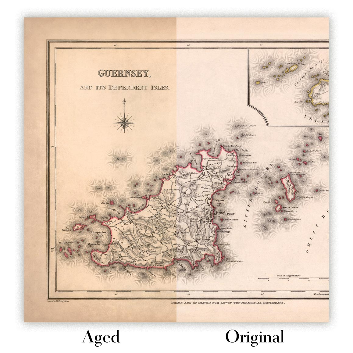
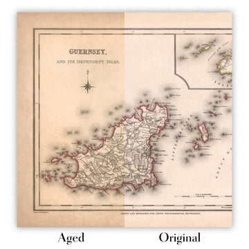
Kartenalterung
Im Laufe der Jahre wurde ich von Kunden hunderte Male gefragt, ob sie eine Karte kaufen könnten, die noch älter.
Nun, jetzt können Sie das, indem Sie „Alter“ auswählen, bevor Sie eine Karte in Ihren Warenkorb legen.
Alle Produktfotos, die Sie auf dieser Seite sehen, zeigen die Karte in ihrer Originalform. So sieht die Karte heute aus.
Wenn Sie „Gealtert“ auswählen, werde ich Ihre Karte von Hand altern lassen. Dazu verwende ich ein spezielles und einzigartiges Verfahren, das ich durch jahrelanges Studium alter Karten und Gespräche mit Forschern zum Verständnis der Chemie alternder Papiere entwickelt habe, und natürlich ... viel Übung!
Wenn Sie sich nicht sicher sind, bleiben Sie bei der Originalfarbe der Karte. Wenn Sie etwas Dunkleres und älter Wenn Sie auf der Suche sind, entscheiden Sie sich für „Aged“.
Sehen Sie einige erstaunliche Beispiele für gealterte Karten.
Wenn Sie aus irgendeinem Grund mit Ihrer Bestellung nicht zufrieden sind, kontaktieren Sie mich für eine unkomplizierte Rückerstattung. Bitte sehen Sie sich unsere Rückgabe- und Rückerstattungsrichtlinien für weitere Informationen an.
Ich bin sehr zuversichtlich, dass Ihnen Ihre restaurierte Karte oder Kunstdruck gefallen wird. Ich mache das seit 1984. Ich bin ein 5-Sterne Etsy-Verkäufer. Ich habe Zehntausende von Karten und Kunstdrucken verkauft und habe über 5.000 echte 5-Sterne-Bewertungen.
Ich verwende einen einzigartigen Prozess, um Karten und Kunstwerke zu restaurieren, der extrem zeitaufwendig und arbeitsintensiv ist. Die Suche nach den Originalkarten und Illustrationen kann Monate dauern. Ich benutze modernste und unglaublich teure Technologie, um sie zu scannen und wiederherzustellen. Daher garantiere ich, dass meine Karten und Kunstdrucke eine Klasse für sich sind - deshalb kann ich eine unkomplizierte Rückerstattung anbieten.
Fast alle meine Karten und Kunstdrucke sehen in großen Größen (200 cm, 6,5 Fuß+) erstaunlich aus und ich kann sie Ihnen auch gerahmt und über einen speziellen Übergrößen-Kurier liefern. Kontaktieren Sie mich, um Ihre speziellen Bedürfnisse zu besprechen.
Or try searching for something!


