


Der Cantino-Planisphäre, 1502: Alte portugiesische Karte der alten und neuen Welten
20% Rabatt auf 2 — 33% Rabatt auf 3
Fügen Sie beliebige zwei berechtigte Artikel zu Ihrem Warenkorb hinzu, um 20% Rabatt zu erhalten. Fügen Sie einen dritten hinzu und er ist kostenlos (entspricht 33% Rabatt, wenn Sie drei kaufen).
Kein Code erforderlich — das Angebot wird automatisch an der Kasse angewendet.
Gültig für alle Standardkarten und Kunstdrucke. Sie können beliebige Designs kombinieren.
Wenn Sie Artikel an mehrere Adressen versenden möchten, kontaktieren Sie uns bitte, bevor Sie Ihre Bestellung aufgeben.
Maßanfertigungen und individuelle Aufträge sind ausgeschlossen.
Kontaktieren Sie uns wenn Sie Fragen haben
 In London gestaltet Hergestellt in Canada
In London gestaltet • Hergestellt in Canada
In London gestaltet Hergestellt in Canada
In London gestaltet • Hergestellt in Canada

Choose your size
Choose your finish


(Mehr Infos)
Geschenkmitteilung & individuelle Ausführung

Wenn Sie eine Geschenkmitteilung oder eine Ausführung (Puzzle, Aluminiumplatte usw.) hinzufügen möchten, die hier nicht verfügbar ist, geben Sie dies bitte in der "Bestellnotiz" beim Checkout an.
Jede Bestellung wird individuell angefertigt. Wenn Sie die Größe leicht anpassen oder auf einem ungewöhnlichen Material drucken lassen möchten, lassen Sie es uns einfach wissen. Wir haben im Laufe der Jahre Tausende von individuellen Bestellungen bearbeitet, daher gibt es (fast) nichts, was wir nicht bewältigen können.
Sie können uns auch kontaktieren, bevor Sie bestellen, wenn Sie möchten!

- Made locally for fast, safe delivery
- No import duty or hidden fees
- Need advice? Message us on WhatsApp
Own a piece of history
7,000+ 5 star reviews


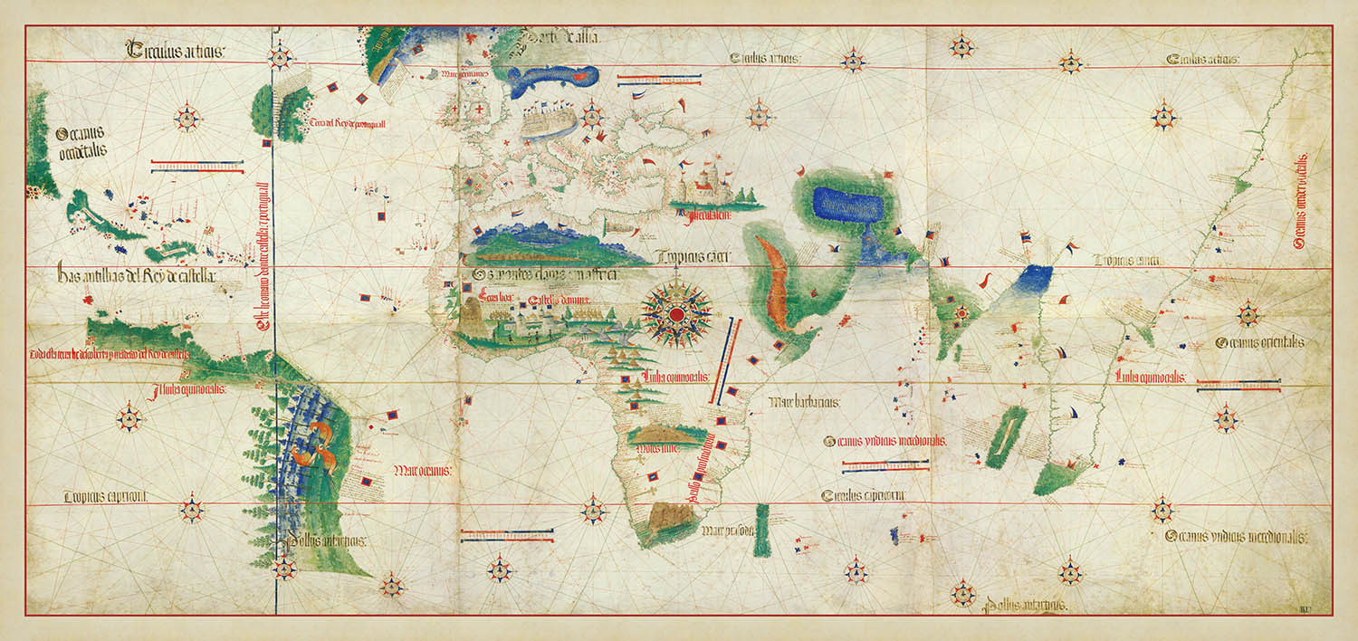
Der Cantino-Planisphäre, der 1502 von einem anonymen portugiesischen Kartographen erstellt wurde, ist ein Meisterwerk der kartografischen Geschichte. Diese exquisite Karte zeigt die Welt, wie sie europäischen Entdeckern zu Beginn der Entdeckungszeit neu offenbart wurde. Sie spiegelt die ehrgeizigen Reisen wider, die die Horizonte Europas erweiterten, und präsentiert neu entdeckte Länder und Seewege zu den Amerikas, Afrika und Indien. Die Karte ist nach Alberto Cantino benannt, einem italienischen Diplomaten, der sie erwarb, und bleibt eines der wertvollsten kartografischen Dokumente ihrer Zeit.
Diese Karte ist ein Zeugnis der navigationalen Fortschritte der Epoche und zeigt komplizierte Kompassrosen und Linien, die die Entdecker über die Meere führen. Die detaillierten Küstenumrisse von Europa, Afrika und den Amerikas heben die Regionen hervor, die den Europäern zu dieser Zeit bekannt waren. Die Darstellung Indiens und der umliegenden Gebiete unterstreicht die strategische Bedeutung dieser Regionen im aufstrebenden Gewürzhandel, einem entscheidenden Motor der Erkundung und wirtschaftlichen Expansion.
Der Cantino-Planisphäre ist nicht nur ein Navigationsinstrument, sondern auch ein Kunstwerk, geschmückt mit dekorativen Elementen wie Fahnen und Wappen, die territoriale Ansprüche von Portugal und Spanien anzeigen. Diese Verzierungen geben Einblick in die geopolitischen Interessen der Zeit und spiegeln den Wettbewerbsgeist der europäischen Mächte wider, die danach strebten, ihre Imperien zu erweitern. Die Anmerkungen der Karte in Latein bereichern ihren historischen Kontext und bieten einen Einblick in die sprachlichen und wissenschaftlichen Konventionen der Zeit.
Die Darstellung bedeutender Wahrzeichen auf der Karte, wie dem Kap der Guten Hoffnung und den Karibischen Inseln, markiert wichtige Punkte im Zeitalter der Entdeckungen. Diese Regionen waren entscheidend für die Entwicklung neuer Handelsrouten und die Errichtung kolonialer Außenposten. Die symbolische Darstellung der Amerikas, mit ihrer üppigen Darstellung Brasiliens, deutet auf das ungenutzte Potenzial und die Ressourcen hin, die auf europäische Entdecker warteten, und bereitet den Boden für Jahrhunderte der Erkundung und Kolonialisierung.
Zusätzlich zu ihrer historischen Bedeutung ist der Cantino-Planisphäre ein visueller Genuss, mit farbcodierten Regionen und Illustrationen von Flora und Fauna, die die Fantasie anregen. Das komplizierte Design der Karte und die Liebe zum Detail machen sie zu einem fesselnden Stück für Sammler und Geschichtsinteressierte gleichermaßen. Als Fenster in eine transformative Periode der Weltgeschichte bietet diese Karte eine einzigartige Perspektive auf die frühen Tage der globalen Erkundung und das bleibende Erbe des Zeitalters der Entdeckungen.
Orte auf dieser Karte
- Europa
- Afrika
- Brasilien
- Indien
- Karibische Inseln
- Mittelmeer
- Kap der Guten Hoffnung
- Atlantischer Ozean
- Indischer Ozean
- Nordeuropa
- Britische Inseln
- Äquator
- Wendekreise des Krebses und des Steinbocks
- Iberische Halbinsel
- Westafrika
- Ostafrika
- Arabische Halbinsel
- Südostasien
- Nordwestafrika
Bemerkenswerte Merkmale & Wahrzeichen
- Kompassrosen sind deutlich sichtbar und unterstützen die Navigation.
- Rhumb-Linien durchziehen die Karte und zeigen Navigationswege an.
- Küstenumrisse von Europa, Afrika und Teilen der Amerikas.
- Darstellung von Indien und umliegenden Regionen.
- Atlantischer Ozean mit detaillierten Inseln.
- Dekorative Elemente, wie Flaggen und heraldische Symbole.
- Annotationen in Latein, die Regionen und Meere kennzeichnen.
- Darstellung des Äquators und der Tropen.
- Detaillierte Darstellung des Mittelmeers.
- Sehenswürdigkeiten in Afrika, einschließlich des Kap der Guten Hoffnung.
- Portugiesische und spanische Flaggen, die territoriale Ansprüche markieren.
- Illustrationen von Flora und Fauna in einigen Regionen.
- Darstellung von Brasilien mit Küstendetails.
- Hinweis auf die Karibischen Inseln.
- Nordeuropa und die Britischen Inseln.
- Bilder von Schiffen, die maritime Erkundung andeuten.
- Farbcodierte Regionen für territoriale Unterscheidungen.
- Maßstabsbalken zur Messung von Entfernungen.
- Hinweis auf den Indischen Ozean und seine Verbindungen.
- Symbolische Darstellung der Amerikas.
Historischer und gestalterischer Kontext
- Name der Karte: Der Cantino-Planisphäre
- Erstellungsdatum: 1502
- Kartenmacher oder Herausgeber: Erstellt von einem anonymen portugiesischen Kartografen.
- Themen und Themen: Illustriert die frühe europäische Erkundung und Entdeckung.
- Design oder Stil: Nautische Karte mit Rhumb-Linien, Kompassrosen und detaillierten Küstenumrissen.
- Historische Bedeutung: Stellt das Wissen über die Welt zu Beginn des Zeitalters der Entdeckungen dar.
- Zusätzliche Hinweise: Spiegelt die geopolitischen Interessen Portugals und Spaniens während des Zeitalters der Erkundung wider.
Bitte überprüfen Sie die Bilder, um sicherzustellen, dass eine bestimmte Stadt oder ein bestimmter Ort auf dieser Karte dargestellt ist. Sie können uns auch kontaktieren und bitten, die Karte für Sie zu überprüfen.
Diese Karte sieht in jeder Größe großartig aus, aber ich empfehle immer, eine größere Größe zu wählen, wenn Sie Platz haben. Auf diese Weise können Sie alle Details leicht erkennen.
Diese Karte sieht bis zu 70 Zoll (180 cm) fantastisch aus. Wenn Sie nach einer größeren Karte suchen, bitte kontaktieren Sie uns.
Bitte beachten Sie: Die Beschriftungen auf dieser Karte sind schwer zu lesen, wenn Sie eine Karte bestellen, die 36 Zoll (90 cm) oder kleiner ist. Die Karte ist immer noch sehr ansprechend, aber wenn Sie die Karte leicht lesen möchten, kaufen Sie bitte eine größere Größe.
Diese Karte ist breiter als die meisten Karten, was sie zu einem perfekten Blickfang über einem Kaminsims, Sofa oder Schreibtisch macht.
Das fünfte Bild zeigt ein Beispiel für meinen Kartenpersonalisierungsservice.
Wenn Sie nach etwas anderem suchen, schauen Sie sich meine Sammlung der besten alten Karten an, um zu sehen, ob Ihnen etwas anderes ins Auge fällt.
Bitte kontaktieren Sie mich, um zu überprüfen, ob ein bestimmter Standort, ein Wahrzeichen oder ein Merkmal auf dieser Karte dargestellt ist.
Dies wäre ein wunderbares Geburtstags-, Weihnachts-, Vatertags-, Abschieds-, Jubiläums- oder Einweihungsgeschenk für jemanden aus den in dieser Karte abgedeckten Gebieten.
This map is also available as a float framed canvas, sometimes known as a shadow gap framed canvas or canvas floater. The map is printed on artist's cotton canvas and then stretched over a handmade box frame. We then "float" the canvas inside a wooden frame, which is available in a range of colours (black, dark brown, oak, antique gold and white). This is a wonderful way to present a map without glazing in front. See some examples of float framed canvas maps and explore the differences between my different finishes.
For something truly unique, this map is also available in "Unique 3D", our trademarked process that dramatically transforms the map so that it has a wonderful sense of depth. We combine the original map with detailed topography and elevation data, so that mountains and the terrain really "pop". For more info and examples of 3D maps, check my Unique 3D page.
Many of our maps and art prints are chosen as thoughtful gifts for homes, offices, studies and meaningful places.
Choose a framed option for the easiest ready-to-hang gift, or choose an unframed print if the recipient may prefer to select their own frame.
We make orders locally in 23 countries around the world, so gifts can often be produced close to the recipient. This helps them arrive faster, travel more safely, and avoid customs or import duty surprises.
- We can deliver directly to the recipient
- Framed pieces arrive ready to hang
- Unframed prints are carefully packed in a strong protective tube
- Almost every order is made locally, for faster, safer gifting
- 90-day returns give the recipient time to decide
If you are not sure what to choose, please contact us. We can help you pick the right map, size, finish or delivery option.
Für die meisten Bestellungen beträgt die Lieferzeit etwa 3 Werktage. Personalisierte und maßgeschneiderte Produkte benötigen länger, da ich die Personalisierung durchführen und sie Ihnen zur Genehmigung zusenden muss, was normalerweise 1 oder 2 Tage dauert.
Bitte beachten Sie, dass sehr große gerahmte Bestellungen in der Regel länger für die Herstellung und Lieferung benötigen.
Wenn Sie möchten, dass Ihre Bestellung bis zu einem bestimmten Datum ankommt, bitte kontaktieren Sie mich, bevor Sie bestellen, damit wir den besten Weg finden können, um sicherzustellen, dass Sie Ihre Bestellung rechtzeitig erhalten.
Ich drucke und rahme Karten und Kunstwerke in 23 Ländern weltweit. Das bedeutet, dass Ihre Bestellung lokal gefertigt wird, was die Lieferzeit verkürzt und sicherstellt, dass sie während der Lieferung nicht beschädigt wird. Sie zahlen nie Zoll oder Einfuhrgebühren, und wir stoßen weniger CO2 in die Luft aus.
Alle meine Karten und Kunstdrucke sind gut verpackt und werden in einem robusten Rohr versendet, wenn sie ungerahmt sind, oder von Schaum umgeben, wenn sie gerahmt sind.
Ich versuche, alle Bestellungen innerhalb von 1 oder 2 Tagen nach Erhalt Ihrer Bestellung zu versenden, obwohl einige Produkte (wie Gesichtsmasken, Tassen und Tragetaschen) länger zur Herstellung benötigen können.
Wenn Sie Express-Lieferung an der Kasse auswählen, priorisieren wir Ihre Bestellung und versenden sie per 1-Tages-Kurier (Fedex, DHL, UPS, Parcelforce).
Nächster Tag Lieferung ist auch in einigen Ländern verfügbar (USA, UK, Singapur, VAE), aber bitte versuchen Sie, früh am Tag zu bestellen, damit wir es rechtzeitig versenden können.
Lesen Sie meinen vollständigen Leitfaden zur Lieferung und lokalen Produktion
Mein Standardrahmen ist ein Galerie-Stil-Rahmen aus schwarzem Eschenholz. Er ist einfach und sieht ziemlich modern aus. Mein Standardrahmen ist etwa 20 mm (0,8 Zoll) breit.
Ich verwende super-klares Acryl (Plexiglas/Acrylt) für das Glas des Rahmens. Es ist leichter und sicherer als Glas – und es sieht besser aus, da die Reflexion geringer ist.
Sechs Standardrahmenfarben sind kostenlos erhältlich (schwarz, dunkelbraun, dunkelgrau, Eiche, weiß und antikgold).
Die meisten Karten, Kunstwerke und Illustrationen sind auch als gerahmte Leinwand erhältlich. Wir verwenden matte (nicht glänzende) Baumwollleinwand, spannen sie über einen nachhaltig beschafften Buchenrahmen und 'schweben' dann das Stück innerhalb eines Holzrahmens. Das Endergebnis ist ziemlich schön, und es gibt keine Verglasung, die im Weg ist.
Alle Rahmen werden "bereit zum Aufhängen" geliefert, entweder mit einer Schnur oder Halterungen auf der Rückseite. Sehr große Rahmen haben schwere Aufhängeplatten und/oder eine Montageschiene. Wenn Sie Fragen haben, können Sie bitte Kontakt aufnehmen.
Sehen Sie sich einige Beispiele meiner gerahmten Karten und gerahmten Leinwandkarten an.
Alternativ kann ich auch alte Karten und Kunstwerke auf Leinwand, Schaumstoffplatten, Baumwollrag und andere Materialien liefern.
Wenn Sie Ihre Karte oder Ihr Kunstwerk selbst rahmen möchten, lesen Sie bitte zuerst meinen Größenleitfaden.
Meine Karten sind äußerst hochwertige Reproduktionen von Originalkarten.
Ich beziehe originale, seltene Karten aus Bibliotheken, Auktionshäusern und Privatsammlungen auf der ganzen Welt, restauriere sie in meiner Londoner Werkstatt und erstelle dann mit speziellen Giclée-Tinten und -Druckern wunderschöne Karten, die sogar noch besser aussehen als das Original.
Meine Karten werden auf säurefreiem, mattem Archivpapier (nicht glänzend) gedruckt, das sich sehr hochwertig anfühlt und fast wie Karton aussieht. Technisch gesehen beträgt das Papiergewicht/die Papierdicke 10mil/200g/m². Es eignet sich perfekt zum Einrahmen.
Ich drucke mit UV-lichtbeständigen Ultrachrome-Giclée-Pigmenttinten von Epson – einige der besten Tinten, die Sie finden können.
Ich kann auch machen Karten auf Leinwand, Baumwolllappen und andere exotische Materialien.
Erfahren Sie mehr über The Unique Maps Co.
Kartenpersonalisierung
Wenn Sie nach dem perfekten Geschenk zum Jahrestag oder zur Einweihung suchen, kann ich Ihre Karte personalisieren, um sie wirklich einzigartig zu machen. Ich kann beispielsweise eine kurze Nachricht hinzufügen, einen wichtigen Ort hervorheben oder das Wappen Ihrer Familie hinzufügen.
Die Möglichkeiten sind nahezu unbegrenzt. Bitte sehen Sie sich meine Kartenpersonalisierungsseite für einige wunderbare Beispiele dessen, was möglich ist.
Um eine personalisierte Karte zu bestellen, wählen Sie „Personalisieren Sie Ihre Karte“, bevor Sie sie in den Warenkorb legen.
In Kontakt kommen wenn Sie nach komplexeren Anpassungen und Personalisierungen suchen.
Kartenalterung
Im Laufe der Jahre wurde ich von Kunden hunderte Male gefragt, ob sie eine Karte kaufen könnten, die noch älter.
Nun, jetzt können Sie das, indem Sie „Alter“ auswählen, bevor Sie eine Karte in Ihren Warenkorb legen.
Alle Produktfotos, die Sie auf dieser Seite sehen, zeigen die Karte in ihrer Originalform. So sieht die Karte heute aus.
Wenn Sie „Gealtert“ auswählen, werde ich Ihre Karte von Hand altern lassen. Dazu verwende ich ein spezielles und einzigartiges Verfahren, das ich durch jahrelanges Studium alter Karten und Gespräche mit Forschern zum Verständnis der Chemie alternder Papiere entwickelt habe, und natürlich ... viel Übung!
Wenn Sie sich nicht sicher sind, bleiben Sie bei der Originalfarbe der Karte. Wenn Sie etwas Dunkleres und älter Wenn Sie auf der Suche sind, entscheiden Sie sich für „Aged“.
Sehen Sie einige erstaunliche Beispiele für gealterte Karten.
Wenn Sie aus irgendeinem Grund mit Ihrer Bestellung nicht zufrieden sind, kontaktieren Sie mich für eine unkomplizierte Rückerstattung. Bitte sehen Sie sich unsere Rückgabe- und Rückerstattungsrichtlinien für weitere Informationen an.
Ich bin sehr zuversichtlich, dass Ihnen Ihre restaurierte Karte oder Kunstdruck gefallen wird. Ich mache das seit 1984. Ich bin ein 5-Sterne Etsy-Verkäufer. Ich habe Zehntausende von Karten und Kunstdrucken verkauft und habe über 5.000 echte 5-Sterne-Bewertungen.
Ich verwende einen einzigartigen Prozess, um Karten und Kunstwerke zu restaurieren, der extrem zeitaufwendig und arbeitsintensiv ist. Die Suche nach den Originalkarten und Illustrationen kann Monate dauern. Ich benutze modernste und unglaublich teure Technologie, um sie zu scannen und wiederherzustellen. Daher garantiere ich, dass meine Karten und Kunstdrucke eine Klasse für sich sind - deshalb kann ich eine unkomplizierte Rückerstattung anbieten.
Fast alle meine Karten und Kunstdrucke sehen in großen Größen (200 cm, 6,5 Fuß+) erstaunlich aus und ich kann sie Ihnen auch gerahmt und über einen speziellen Übergrößen-Kurier liefern. Kontaktieren Sie mich, um Ihre speziellen Bedürfnisse zu besprechen.
Or try searching for something!


