


Ancienne carte coloniale du Kenya, Ouganda, Rwanda et Tanzanie par Edward Stanford, 1926: Nairobi, Kampala, lac Victoria, Kilimandjaro, chemin de fer de l'Ouganda
Achetez 2, obtenez 1 de plus gratuit
Si vous ajoutez 2 articles à votre panier, vous pouvez ajouter un troisième produit gratuitement. La remise est automatique - aucun code requis.
Cela équivaut à 33% de réduction, ce qui est la meilleure offre que vous trouverez dans ma boutique cette année.
Cela fonctionne pour toutes les cartes et œuvres d'art. Vous pouvez commander 3 de la même chose, ou 3 choses différentes. Si vous souhaitez les envoyer à 2 ou 3 adresses, contactez-moi avant de commander.
Les cartes personnalisées sont exclues, car elles prennent trop de temps à réaliser et nous préférons prendre notre temps plutôt que de nous précipiter à travers de nombreuses commandes.
Contactez-moi si vous avez des questions
-
![]() Handmade in Canada
Handmade in Canada

-
FREE worldwide delivery in 2-3 days ⓘ
Free delivery in 2-3 days
Your map should be delivered in 2-3 working days with free delivery, worldwide.
We make maps by hand locally in 23 countries, including Canada
![]() . If you're buying a gift for someone in another country, we will make the map locally to them.
. If you're buying a gift for someone in another country, we will make the map locally to them.You will never pay import tax or customs duty.
Express delivery is available at checkout which can reduce the delivery time to 1-2 days.
Please note that personalised maps, and larger framed maps, can take longer to produce and deliver.
If you need your order to arrive by a certain date, contact me and we can discuss your options.
-
Complimentary gifting & design advice
ⓘ
Complimentary gifting & design advice
Available almost 24/7 on WhatsApp and email — we usually reply within minutes. We can help you:
- Choose a perfectly personalised gift
- Send a digital gift preview to the recipient
- Pick the ideal size for your wall
- Select the right finish and frame
Quick, friendly advice so you can order with confidence.
For last minute gifts, consider buying a digital gift card. We have over 5,000 maps and art prints to choose from.
-
90-day returns & 5-year guarantee
ⓘ
90 jours pour retourner et obtenir un remboursement
Les produits peuvent être retournés dans les 90 jours pour un remboursement complet, ou un échange contre un autre produit.
Pour les articles personnalisés et faits sur mesure, nous pouvons vous offrir un crédit en magasin ou une carte-cadeau non expirante, car nous ne pouvons pas revendre les commandes personnalisées.
Si vous avez des questions, contactez-nous. Pour plus d'informations, consultez notre politique de retours et d'échanges.

This is a museum-grade archival print from the original 1926 map — restored in our workshop and made to order on 220gsm archival matte paper or 400gsm artist's cotton canvas with pigment inks.
Professional framing & free personalisation available.
1. Choose a size
2. Frame & personalise your map
Make your map unique with framing, hand-drawn customisation, vintage ageing, pop art text, unique 3D styling and more.


Message cadeau & finition personnalisée

Si vous souhaitez ajouter un message cadeau, ou une finition (puzzle, panneau en aluminium, etc.) qui n'est pas disponible ici, veuillez le demander dans la "note de commande" lors de votre passage à la caisse.
Chaque commande est fabriquée sur mesure, donc si vous avez besoin d'ajuster légèrement la taille, ou d'imprimer sur un matériau inhabituel, faites-le nous savoir. Nous avons réalisé des milliers de commandes personnalisées au fil des ans, donc il n'y a (presque) rien que nous ne puissions gérer.
Vous pouvez également nous contacter avant de passer votre commande, si vous le souhaitez !

- Handmade locally. No import duty or tax
- FREE worldwide delivery
- 90-day returns & 5-year product guarantee
- Questions? WhatsApp me any time
Own a piece of history
7,000+ 5 star reviews


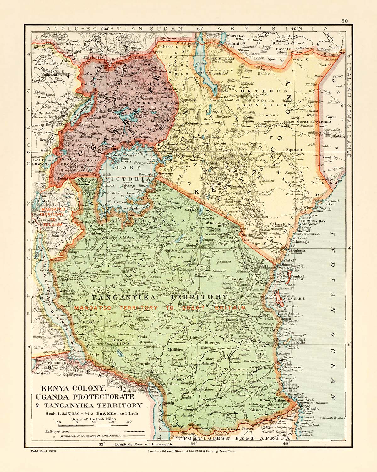
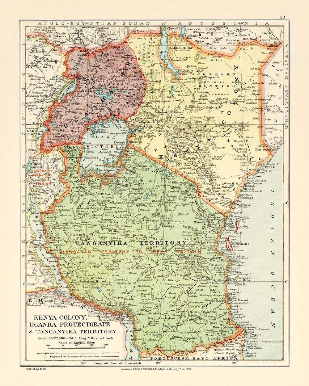
Entrez dans le monde captivant de la cartographie du début du 20e siècle avec "Kenya Colony, Uganda Protectorate & Tanganyika Territory", une carte qui se dresse à la fois comme un témoignage de l'ambition coloniale et un chef-d'œuvre de représentation géographique. Réalisée en 1926 par la célèbre Edward Stanford Ltd., cette carte a été publiée à une époque où l'Empire britannique traçait méticuleusement ses domaines en Afrique de l'Est. Le titre original évoque l'esprit d'exploration et d'administration de l'époque, offrant un aperçu d'un paysage à l'aube de la transformation. La délimitation soignée des frontières politiques et des infrastructures sur cette carte révèle non seulement l'étendue de l'influence britannique mais aussi la complexité et la diversité des régions qui deviendraient le Kenya, l'Ouganda, le Rwanda et la Tanzanie modernes.
Edward Stanford Ltd., le légendaire cartographe basé à Londres, a apporté à cette œuvre un héritage de précision et d'art hérité de John Arrowsmith, l'un des grands pionniers de la cartographie britannique. Les cartes de Stanford étaient réputées pour leur clarté, leur précision et leur élégance, servant à la fois les explorateurs, les chercheurs et les hommes d'État. Cette carte particulière, dessinée pour le prestigieux London Atlas of Universal Geography, reflète les normes élevées de l'édition "Whitehall"—un atlas prisé pour sa couverture exhaustive et son détail méticuleux. L'inclusion d'une légende détaillée, de lignes de latitude et de longitude, et d'une échelle barométrique en miles anglais témoigne de l'engagement du cartographe envers la précision scientifique et l'utilité pratique.
Le détail physique et politique de la carte est extraordinaire, capturant la tapisserie complexe des paysages naturels et humains de l'Afrique de l'Est. Les grands lacs—Victoria, Albert, Edward, Kivu et Tanganyika—sont rendus avec un soin exquis, leurs rivages tentaculaires et les îles comme les îles Sese et Ukerewe invitant à un examen plus attentif. Des rivières telles que le Victoria Nile et le Tana serpentent à travers la carte, traçant le sang vital des civilisations de la région. La côte de l'océan Indien, avec son port prominent de Mombasa, évoque des siècles de commerce maritime et d'échanges culturels, tandis que les chemins de fer intérieurs—le plus notable étant le chemin de fer de l'Ouganda—annoncent l'aube des infrastructures modernes et de la connectivité.
Surplombant les plaines, la topographie dramatique de la région prend vie grâce à l'utilisation de hachures, une technique cartographique classique qui transmet la grandeur des montagnes et des vallées. Les légendaires montagnes Ruwenzori, souvent appelées les "Montagnes de la Lune", sont représentées aux côtés des sommets emblématiques du mont Kenya, du mont Elgon et du mont Kilimandjaro. Ces merveilles naturelles, enveloppées de mythes et d'intrigues scientifiques, dominent le paysage et ont longtemps inspiré explorateurs et naturalistes. Le rendu soigné des frontières sur la carte—entre la colonie du Kenya, le protectorat de l'Ouganda et le territoire de Tanganyika—révèle les réalités géopolitiques de l'époque, tout en laissant entrevoir l'émergence future de nations africaines indépendantes.
Au-delà de ses caractéristiques naturelles, la carte est un document vivant des centres urbains et des établissements dynamiques de la région. Des villes comme Nairobi, Kampala, Dar es Salaam et Kigali sont marquées comme des pôles d'administration, de commerce et de culture, chacune destinée à devenir de grandes métropoles dans les décennies à venir. Des villes comme Mombasa, Kisumu (alors Port Florence), Jinja et Arusha sont également présentées, leurs positions révélant les modèles de développement colonial et d'établissement indigène. Cette carte n'est pas seulement une œuvre d'art mais un artefact historique—une invitation à explorer l'interaction dynamique de la géographie, de l'histoire et de l'effort humain dans l'une des régions les plus fascinantes d'Afrique.
Villes et villages sur cette carte
- Kenya (aujourd'hui) :
- Nairobi
- Mombasa
- Kisumu (étiqueté comme Port Florence)
- Nakuru
- Eldoret (étiqueté comme Eldoret ou Uasin Gishu)
- Nyeri
- Machakos
-
Thika
-
Ouganda (aujourd'hui) :
- Kampala
- Jinja
- Entebbe
- Masaka
- Gulu
- Mbale
- Fort Portal (étiqueté comme Fort Portal)
-
Masindi
-
Tanzanie (Territoire de Tanganyika, aujourd'hui) :
- Dar es Salaam
- Mwanza
- Tabora
- Kigoma
- Dodoma
- Arusha
- Moshi
- Tanga
-
Bukoba
-
Rwanda (aujourd'hui) :
- Kigali (étiqueté comme Kigaali)
Caractéristiques et monuments notables
- Lacs majeurs : Lac Victoria, Lac Albert, Lac Edward, Lac Kivu, Lac Tanganyika
- Rivières majeures : Nil (Nil Victoria), rivière Tana, rivière Rufiji, et d'autres systèmes de drainage significatifs
- Chaînes de montagnes et sommets : Monts Ruwenzori (Montagnes de la Lune), Mont Kenya, Mont Elgon, Mont Kilimandjaro
- Frontières : Limites politiques entre la colonie du Kenya, le protectorat de l'Ouganda, le territoire de Tanganyika et les régions voisines
- Chemins de fer : Lignes ferroviaires clairement marquées, y compris le chemin de fer de l'Ouganda et d'autres lignes secondaires
- Îles : Îles Sese (dans le lac Victoria), île Ukerewe (lac Victoria), et d'autres petites îles
- Côtes : Côte de l'océan Indien, y compris la zone portuaire de Mombasa
Contexte historique et de conception
- Créé en 1926 par Edward Stanford Ltd., un éditeur de cartes renommé basé à Londres, établi en 1854, héritant de l'héritage de John Arrowsmith
- Publié dans le cadre de l'Atlas de géographie universelle de Stanford à Londres, édition "Whitehall"
- Dépeint des régions correspondant à l'actuel Kenya, Ouganda, Rwanda et Tanzanie (historiquement la colonie du Kenya, le protectorat de l'Ouganda et le territoire de Tanganyika)
- Limites politiques détaillées, caractéristiques topographiques (relief et élévation utilisant des hachures), infrastructures clés telles que les chemins de fer, les plans d'eau, les systèmes de drainage et les îles
- Comprend une légende, des lignes de latitude et de longitude, et une échelle barométrique en miles anglais pour une navigation pratique
- Fournit un aperçu de la géographie politique et physique de l'Afrique de l'Est pendant l'ère coloniale, reflétant les limites administratives britanniques et le développement des infrastructures
- Précieux pour comprendre l'évolution de la cartographie et des pratiques de cartographie coloniale au début du 20ème siècle
Veuillez vérifier les images pour vous assurer qu'une ville ou un lieu spécifique est représenté sur cette carte. Vous pouvez également nous contacter et nous demander de vérifier la carte pour vous.
Cette carte est magnifique à toutes les tailles, mais je recommande toujours d'opter pour une taille plus grande si vous avez de l'espace. De cette façon, vous pouvez facilement distinguer tous les détails.
Cette carte est incroyable à des tailles allant jusqu'à 50 pouces (125 cm). Si vous recherchez une carte plus grande, veuillez nous contacter.
Le modèle sur les images de la liste tient la version 16x20 pouces (40x50 cm) de cette carte.
La cinquième image de la liste montre un exemple de mon service de personnalisation de carte.
Si vous recherchez quelque chose de légèrement différent, consultez ma collection des meilleures anciennes cartes pour voir si quelque chose d'autre attire votre attention.
Veuillez me contacter pour vérifier si un certain emplacement, monument ou caractéristique est représenté sur cette carte.
Cela ferait un merveilleux cadeau d'anniversaire, de Noël, pour la fête des pères, un départ au travail, un anniversaire de mariage ou une pendaison de crémaillère pour quelqu'un des zones couvertes par cette carte.
Cette carte est disponible en tant qu'impression giclée sur papier mat d'archives sans acide, ou vous pouvez l'acheter encadrée. Le cadre est un joli cadre noir simple qui convient à la plupart des esthétiques. Veuillez nous contacter si vous souhaitez une couleur ou un matériau de cadre différent. Mes cadres sont vitrées avec un acrylique de musée super clair (perspex/acrylite), qui est significativement moins réfléchissant que le verre, plus sûr, et arrivera toujours en parfait état.
This map is also available as a float framed canvas, sometimes known as a shadow gap framed canvas or canvas floater. The map is printed on artist's cotton canvas and then stretched over a handmade box frame. We then "float" the canvas inside a wooden frame, which is available in a range of colours (black, dark brown, oak, antique gold and white). This is a wonderful way to present a map without glazing in front. See some examples of float framed canvas maps and explore the differences between my different finishes.
For something truly unique, this map is also available in "Unique 3D", our trademarked process that dramatically transforms the map so that it has a wonderful sense of depth. We combine the original map with detailed topography and elevation data, so that mountains and the terrain really "pop". For more info and examples of 3D maps, check my Unique 3D page.
Pour la plupart des commandes, le délai de livraison est d'environ 3 jours ouvrables. Les produits personnalisés et sur mesure prennent plus de temps, car je dois faire la personnalisation et vous l'envoyer pour approbation, ce qui prend généralement 1 ou 2 jours.
Veuillez noter que les grandes commandes encadrées prennent généralement plus de temps à réaliser et à livrer.
Si vous avez besoin que votre commande arrive à une date précise, veuillez me contacter avant de passer votre commande afin que nous puissions trouver le meilleur moyen de nous assurer que vous receviez votre commande à temps.
J'imprime et encadre des cartes et des œuvres d'art dans 23 pays à travers le monde. Cela signifie que votre commande sera réalisée localement, ce qui réduit le temps de livraison et garantit qu'elle ne sera pas endommagée pendant le transport. Vous ne paierez jamais de droits de douane ou d'importation, et nous mettrons moins de CO2 dans l'air.
Toutes mes cartes et impressions artistiques sont bien emballées et envoyées dans un tube robuste si non encadrées, ou entourées de mousse si encadrées.
J'essaie d'envoyer toutes les commandes dans les 1 ou 2 jours suivant la réception de votre commande, bien que certains produits (comme les masques, les mugs et les sacs fourre-tout) puissent prendre plus de temps à réaliser.
Si vous choisissez Livraison Express lors du paiement, nous donnerons la priorité à votre commande et l'enverrons par un service de messagerie de 1 jour (Fedex, DHL, UPS, Parcelforce).
La livraison le lendemain est également disponible dans certains pays (États-Unis, Royaume-Uni, Singapour, Émirats Arabes Unis), mais veuillez essayer de commander tôt dans la journée afin que nous puissions l'envoyer à temps.
Lisez mon guide complet sur la livraison et la production locale
Mon cadre standard est un cadre en bois dur noir de style galerie. Il est simple et a un aspect assez moderne. Mon cadre standard mesure environ 20 mm (0,8 po) de large.
J'utilise de l'acrylique super clair (perspex/acrylite) pour le verre du cadre. C'est plus léger et plus sûr que le verre - et cela a meilleur aspect, car la réflexivité est plus faible.
Six couleurs de cadre standard sont disponibles gratuitement (noir, marron foncé, gris foncé, chêne, blanc et or antique). Des encadrements et montages/matelassages personnalisés sont disponibles si vous recherchez autre chose.
La plupart des cartes, œuvres d'art et illustrations sont également disponibles sous forme de toile encadrée. Nous utilisons une toile en coton mate (non brillante), que nous tendons sur un cadre en bois de boîte provenant de sources durables, puis nous 'flottions' la pièce à l'intérieur d'un cadre en bois. Le résultat final est assez beau, et il n'y a pas de vitrage qui gêne.
Tous les cadres sont fournis "prêts à accrocher", avec soit une corde, soit des supports à l'arrière. Les très grands cadres auront des plaques de suspension lourdes et/ou une latte de montage. Si vous avez des questions, veuillez nous contacter.
Voir quelques exemples de mes cartes encadrées et de cartes en toile encadrées.
Alternativement, je peux également fournir de vieilles cartes et œuvres d'art sur toile, sur panneau en mousse, en coton et d'autres matériaux.
Si vous souhaitez encadrer votre carte ou œuvre d'art vous-même, veuillez lire d'abord mon guide des tailles.
Certaines de mes anciennes cartes sont maintenant disponibles en tant que toiles encadrées. Veuillez me contacter si vous souhaitez commander une taille qui n'est pas disponible dans ma boutique.
Les anciennes cartes en toile sont une alternative intéressante aux cartes encadrées de manière conventionnelle. Selon vos goûts personnels et la décoration de votre pièce, les cartes en toile peuvent "se démarquer" un peu plus qu'une carte encadrée.
Mes cartes sont des reproductions de cartes originales de très haute qualité.
Je recherche des cartes originales et rares auprès de bibliothèques, de maisons de ventes aux enchères et de collections privées du monde entier, je les restaure dans mon atelier de Londres, puis j'utilise des encres et des imprimantes giclées spécialisées pour créer de magnifiques cartes encore plus belles que l'originale.
Mes cartes sont imprimées sur du papier d’archives mat (non brillant) sans acide qui semble de très haute qualité et ressemble presque à une carte. En termes techniques, le grammage/épaisseur du papier est de 10 mil/200 g/m². C'est parfait pour l'encadrement.
J’imprime avec des encres pigmentaires Epson ultrachrome giclée UV résistantes à la décoloration – certaines des meilleures encres que vous puissiez trouver.
je peux aussi faire cartes sur toile, chiffon en coton et autres matériaux exotiques.
En savoir plus sur Unique Maps Co..
Personnalisation de la carte
Si vous recherchez le cadeau parfait pour un anniversaire ou une pendaison de crémaillère, je peux personnaliser votre carte pour la rendre vraiment unique. Par exemple, je peux ajouter un court message, mettre en évidence un lieu important ou ajouter les armoiries de votre famille.
Les options sont presque infinies. S'il vous plaît voir mon page de personnalisation de la carte pour quelques merveilleux exemples de ce qui est possible.
Pour commander une carte personnalisée, sélectionnez « personnaliser votre carte » avant de l'ajouter à votre panier.
Entrer en contact si vous recherchez des personnalisations et des personnalisations plus complexes.
Vieillissement de la carte
Au fil des ans, des clients m'ont demandé des centaines de fois s'ils pouvaient acheter une carte qui semble uniforme. plus vieux.
Eh bien, vous pouvez désormais le faire en sélectionnant Aged avant d'ajouter une carte à votre panier.
Toutes les photos de produits que vous voyez sur cette page montrent la carte dans sa forme originale. Voilà à quoi ressemble la carte aujourd'hui.
Si vous sélectionnez Vieilli, je vieillirai votre carte à la main, en utilisant un processus spécial et unique développé au cours d'années d'étude de cartes anciennes, de discussions avec des chercheurs pour comprendre la chimie du vieillissement du papier, et bien sûr... beaucoup de pratique !
Si vous n'êtes pas sûr, respectez la couleur originale de la carte. Si vous voulez quelque chose d'un peu plus sombre et plus vieux à la recherche, optez pour Aged.
Si vous n'êtes pas satisfait de votre commande pour une raison quelconque, contactez-moi pour un remboursement sans conditions. Veuillez consulter notre politique de retours et de remboursements pour plus d'informations.
Je suis très confiant que vous aimerez votre carte restaurée ou votre impression artistique. Je fais cela depuis 1984. Je suis un vendeur Etsy 5 étoiles. J'ai vendu des dizaines de milliers de cartes et d'impressions artistiques et j'ai plus de 5 000 vrais avis 5 étoiles.
J'utilise un processus unique pour restaurer des cartes et des œuvres d'art qui est extrêmement chronophage et exigeant en main-d'œuvre. Trouver les cartes et illustrations originales peut prendre des mois. J'utilise une technologie de pointe et incroyablement coûteuse pour les numériser et les restaurer. En conséquence, je garantis que mes cartes et impressions artistiques sont d'une qualité supérieure - c'est pourquoi je peux offrir un remboursement sans conditions.
Presque toutes mes cartes et impressions artistiques ont l'air incroyables en grandes tailles (200 cm, 6,5 pieds+) et je peux également les encadrer et vous les livrer, via un transporteur spécial surdimensionné. Contactez-moi pour discuter de vos besoins spécifiques.
Or try searching for something!


