

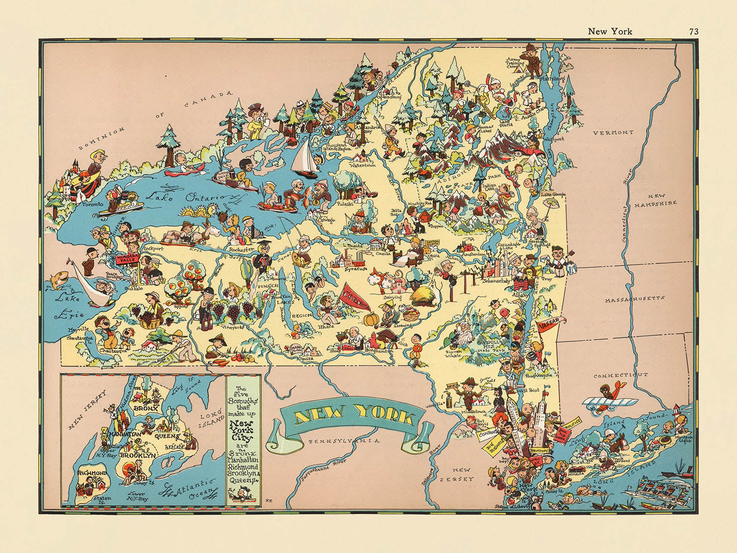


Carte picturale de New York par Ruth Taylor White, 1935: NYC, chutes du Niagara, Adirondacks, canal Érié, fleuve Hudson
Achetez 2, obtenez 1 gratuit
Si vous ajoutez 2 articles à votre panier, vous pouvez ajouter un troisième produit gratuitement.
Cela fonctionne pour toutes les cartes et œuvres d'art, y compris les pièces personnalisées et sur mesure. Vous pouvez commander 3 de la même chose, ou 3 choses différentes.
Cela équivaut à une remise de 33 %, qui sera la plus grande remise disponible dans ma boutique cette année.
Veuillez profiter de l'offre et couvrir vos murs de belles cartes et œuvres d'art !
Contactez-moi si vous avez des questions.

-
![]() Handmade in Canada
Handmade in Canada
-
FREE worldwide delivery in 2-3 days ⓘ
Free delivery in 2-3 days
Your map should be delivered in 2-3 working days with free delivery, worldwide.
Deliveries over the Christmas and New Year period may be slightly delayed, as couriers and postal services catch up with a huge backlog of packages.
We make maps by hand locally in 23 countries, including Canada
![]() . If you're buying a gift for someone in another country, we will make the map locally to them.
. If you're buying a gift for someone in another country, we will make the map locally to them.You will never pay import tax or customs duty.
Express delivery is available at checkout which can reduce the delivery time to 1-2 days.
Please note that personalised maps, and larger framed maps, can take longer to produce and deliver.
If you need your order to arrive by a certain date, contact me and we can discuss your options.
-
FREE gift preview
ⓘ
Digital gift preview
After you complete your order, you can send a beautiful digital preview to the gift recipient. Just provide their email address and we'll do the rest. (Their email address will not be stored or used for any other purpose.)
This is perfect if you're concerned that your order might not arrive in time.
You can also buy a real non-expiring gift card, and email it directly to the recipient, so they can buy their own map or artwork.
-
90 day money back guarantee
ⓘ
90 jours pour retourner et obtenir un remboursement
Les produits peuvent être retournés dans les 90 jours pour un remboursement complet, ou un échange contre un autre produit.
Pour les articles personnalisés et faits sur mesure, nous pouvons vous offrir un crédit en magasin ou une carte-cadeau non expirante, car nous ne pouvons pas revendre les commandes personnalisées.
Si vous avez des questions, contactez-nous. Pour plus d'informations, consultez notre politique de retours et d'échanges.

My maps are rare, museum-grade, restored old maps sourced from libraries, auction houses and private collections across the globe.
Framing & free personalisation available
1. Select your size
Click here to order a custom size.
2. Frame & personalise your map
Make your map unique with framing, hand-drawn customisation, vintage ageing, pop art text, unique 3D styling and more.


Message cadeau & finition personnalisée

Si vous souhaitez ajouter un message cadeau, ou une finition (puzzle, panneau en aluminium, etc.) qui n'est pas disponible ici, veuillez le demander dans la "note de commande" lors de votre passage à la caisse.
Chaque commande est fabriquée sur mesure, donc si vous avez besoin d'ajuster légèrement la taille, ou d'imprimer sur un matériau inhabituel, faites-le nous savoir. Nous avons réalisé des milliers de commandes personnalisées au fil des ans, donc il n'y a (presque) rien que nous ne puissions gérer.
Vous pouvez également nous contacter avant de passer votre commande, si vous le souhaitez !

- Handmade locally. No import duty or tax
- FREE worldwide delivery
- Love it or your money back (90 days)
- Questions? WhatsApp me any time
Own a piece of history
5,000+ 5 star reviews


Entrez dans le monde vibrant de New York des années 1930 avec cette carte captivante, intitulée à l'origine « New York.. » et réalisée par la renommée Ruth Taylor White en 1935. Ce chef-d'œuvre pictural est plus qu'un document géographique—c'est une fenêtre sur l'esprit et la culture d'une époque révolue. Chaque limite de comté est rendue avec clarté, tandis que l'ensemble de l'État prend vie à travers une tapisserie de couleurs, de fantaisie et de flair artistique. Les illustrations ludiques, riches en détails d'époque, vous invitent à explorer le caractère et le charme qui ont défini New York pendant les années d'entre-deux-guerres.
Ruth Taylor White, célébrée pour son approche imaginative de la cartographie, apporte une chaleur et un humour indéniables à son travail. Ses cartes, souvent créées en collaboration avec l'éditeur Frank J. Taylor, sont prisées pour leur capacité à mélanger précision géographique et récit culturel. Ici, l'art de White transforme l'État de New York en un tableau vivant, où l'identité unique de chaque région est aimablement dépeinte à travers des scènes vibrantes et des caricatures astucieuses. Son style distinctif—à la fois précis et exubérant—en a fait des atlas picturaux très recherchés par les collectionneurs et les connaisseurs.
Le design de la carte est une fusion harmonieuse du thématique et du pictural, avec des illustrations exagérées qui amusent et informent. Des majestueuses montagnes Adirondack et Catskill à l'emblématique fleuve Hudson, chaque point de repère naturel est non seulement étiqueté mais aussi mis en vie avec des vignettes charmantes. Les puissantes chutes du Niagara tonnent dans un tourbillon de couleurs, tandis que le canal Erie sinueux et les lacs Finger étincelants sont rendus avec précision et éclat artistique. Le lac Ontario et le lac Érié, ainsi que le fleuve Saint-Laurent, ancrent les limites nord et ouest de la carte, soulignant l'importance des voies navigables dans l'histoire de New York.
Au-delà de ses merveilles naturelles, la carte célèbre la tapisserie culturelle et économique de l'État. Des illustrations fantaisistes de l'agriculture, des vaches laitières et des usines animées rendent hommage au patrimoine agricole et industriel de New York. Les activités récréatives—pêche, chasse, ski—parsemment le paysage, reflétant les diverses opportunités d'aventure et de loisirs de l'État. La présence de figures amérindiennes et des références à l'histoire coloniale précoce enrichissent encore le récit, offrant un aperçu nuancé des couches d'expérience humaine qui ont façonné New York.
Peut-être les plus enchanteurs sont les représentations des villes et des villages emblématiques de New York, de la silhouette élancée de New York City aux rues historiques d'Albany, Buffalo et Rochester. Chaque établissement est soigneusement positionné, sa signification moderne résonnant dans la représentation imaginative de White. La Statue de la Liberté se dresse en sentinelle près de la métropole, tandis que des bateaux à vapeur et des navires sillonnent les grands fleuves et lacs, symbolisant le lien durable de l'État avec le commerce et l'exploration. Cette carte n'est pas simplement un enregistrement de lieux—c'est une célébration de la vitalité durable de New York, rendue avec l'art et l'esprit qui définissent l'héritage durable de Ruth Taylor White.
Villes et villages sur cette carte
- New York City
- Buffalo
- Rochester
- Yonkers
- Syracuse
- Albany
- Schenectady
- Utica
- Binghamton
- Troy
- Chutes du Niagara
- Poughkeepsie
- Elmira
- Jamestown
- Rome
- Ithaca
- Auburn
- Newburgh
- Kingston
- Glens Falls
Caractéristiques et monuments notables
- Les limites des comtés sont clairement délimitées.
- Les montagnes Adirondack sont illustrées et étiquetées.
- Les montagnes Catskill sont illustrées et étiquetées.
- Le fleuve Hudson est représenté et étiqueté.
- Les chutes du Niagara sont illustrées et étiquetées.
- La région des Finger Lakes est illustrée et étiquetée.
- Le canal Érié est représenté et étiqueté.
- Le lac Ontario et le lac Érié sont illustrés et étiquetés.
- Le fleuve Saint-Laurent est représenté et étiqueté.
- La carte comprend des illustrations fantaisistes de l'agriculture, du ski et d'autres activités régionales.
- Des illustrations de figures amérindiennes et des références à l'histoire coloniale précoce sont présentes.
- La carte présente des images de bateaux à vapeur et de navires sur les voies navigables majeures.
- Il y a des représentations d'activités récréatives telles que la pêche, la chasse et les sports d'hiver.
- La carte comprend des illustrations d'activités industrielles, telles que des usines et des moulins.
- La statue de la Liberté est illustrée près de New York.
- La carte présente des images de vaches laitières, faisant référence à l'industrie laitière de New York.
Contexte historique et de conception
- Nom de la carte : "New York"
- Titre original : "New York.."
- Date de création : 1935
- Cartographe : Ruth Taylor White
- La carte est une carte thématique et picturale de comté ou d'État, faisant partie d'un atlas pictural fantaisiste des États-Unis.
- La carte présente des illustrations vibrantes, de style cartoon, représentant des scènes stéréotypées et des moments culturels de New York dans les années 1930.
- Les illustrations capturent l'essence et le caractère de New York à l'époque, utilisant des images ludiques et colorées.
- La carte est à la fois un document historique et une œuvre d'art, reflétant le charme et la culture de New York dans les années 1930.
- Le design est hautement stylisé, avec des représentations exagérées et humoristiques de personnes, d'activités et d'industries.
- La carte met l'accent sur des thèmes tels que l'agriculture, la récréation, l'industrie et la culture régionale.
- La carte est significative en tant qu'exemple de cartographie picturale des années 1930, alliant géographie et commentaire artistique et culturel.
Veuillez vérifier les images pour vous assurer qu'une ville ou un lieu spécifique est représenté sur cette carte. Vous pouvez également nous contacter et nous demander de vérifier la carte pour vous.
Cette carte a fière allure à toutes les tailles, mais je recommande toujours d'opter pour une taille plus grande si vous avez de l'espace. De cette façon, vous pouvez facilement distinguer tous les détails.
Cette carte est incroyable à des tailles allant jusqu'à 50 pouces (125 cm). Si vous recherchez une carte plus grande, veuillez nous contacter.
Le modèle sur les images de la liste tient la version 18x24 pouces (45x60 cm) de cette carte.
La cinquième image de la liste montre un exemple de mon service de personnalisation de carte.
Si vous recherchez quelque chose de légèrement différent, consultez ma collection des meilleures anciennes cartes pour voir si quelque chose d'autre attire votre attention.
Veuillez me contacter pour vérifier si un certain emplacement, un point de repère ou une caractéristique est représenté sur cette carte.
Cela ferait un merveilleux cadeau d'anniversaire, de Noël, pour la fête des pères, de départ au travail, d'anniversaire de mariage ou de pendaison de crémaillère pour quelqu'un des régions couvertes par cette carte.
Cette carte est disponible en tant qu'impression giclée sur papier mat d'archivage sans acide, ou vous pouvez l'acheter encadrée. Le cadre est un joli cadre noir simple qui convient à la plupart des esthétiques. Veuillez me contacter si vous souhaitez une couleur ou un matériau de cadre différent. Mes cadres sont vitrées avec de l'acrylique de musée super clair (perspex/acrylite), qui est significativement moins réfléchissant que le verre, plus sûr, et arrivera toujours en parfait état.
This map is also available as a float framed canvas, sometimes known as a shadow gap framed canvas or canvas floater. The map is printed on artist's cotton canvas and then stretched over a handmade box frame. We then "float" the canvas inside a wooden frame, which is available in a range of colours (black, dark brown, oak, antique gold and white). This is a wonderful way to present a map without glazing in front. See some examples of float framed canvas maps and explore the differences between my different finishes.
For something truly unique, this map is also available in "Unique 3D", our trademarked process that dramatically transforms the map so that it has a wonderful sense of depth. We combine the original map with detailed topography and elevation data, so that mountains and the terrain really "pop". For more info and examples of 3D maps, check my Unique 3D page.
Pour la plupart des commandes, le délai de livraison est d'environ 3 jours ouvrables. Les produits personnalisés et sur mesure prennent plus de temps, car je dois faire la personnalisation et vous l'envoyer pour approbation, ce qui prend généralement 1 ou 2 jours.
Veuillez noter que les grandes commandes encadrées prennent généralement plus de temps à réaliser et à livrer.
Si vous avez besoin que votre commande arrive à une date précise, veuillez me contacter avant de passer votre commande afin que nous puissions trouver le meilleur moyen de nous assurer que vous receviez votre commande à temps.
J'imprime et encadre des cartes et des œuvres d'art dans 23 pays à travers le monde. Cela signifie que votre commande sera réalisée localement, ce qui réduit le temps de livraison et garantit qu'elle ne sera pas endommagée pendant le transport. Vous ne paierez jamais de droits de douane ou d'importation, et nous mettrons moins de CO2 dans l'air.
Toutes mes cartes et impressions artistiques sont bien emballées et envoyées dans un tube robuste si non encadrées, ou entourées de mousse si encadrées.
J'essaie d'envoyer toutes les commandes dans les 1 ou 2 jours suivant la réception de votre commande, bien que certains produits (comme les masques, les mugs et les sacs fourre-tout) puissent prendre plus de temps à réaliser.
Si vous choisissez Livraison Express lors du paiement, nous donnerons la priorité à votre commande et l'enverrons par un service de messagerie de 1 jour (Fedex, DHL, UPS, Parcelforce).
La livraison le lendemain est également disponible dans certains pays (États-Unis, Royaume-Uni, Singapour, Émirats Arabes Unis), mais veuillez essayer de commander tôt dans la journée afin que nous puissions l'envoyer à temps.
Lisez mon guide complet sur la livraison et la production locale
Mon cadre standard est un cadre en bois dur noir de style galerie. Il est simple et a un aspect assez moderne. Mon cadre standard mesure environ 20 mm (0,8 po) de large.
J'utilise de l'acrylique super clair (perspex/acrylite) pour le verre du cadre. C'est plus léger et plus sûr que le verre - et cela a meilleur aspect, car la réflexivité est plus faible.
Six couleurs de cadre standard sont disponibles gratuitement (noir, marron foncé, gris foncé, chêne, blanc et or antique). Des encadrements et montages/matelassages personnalisés sont disponibles si vous recherchez autre chose.
La plupart des cartes, œuvres d'art et illustrations sont également disponibles sous forme de toile encadrée. Nous utilisons une toile en coton mate (non brillante), que nous tendons sur un cadre en bois de boîte provenant de sources durables, puis nous 'flottions' la pièce à l'intérieur d'un cadre en bois. Le résultat final est assez beau, et il n'y a pas de vitrage qui gêne.
Tous les cadres sont fournis "prêts à accrocher", avec soit une corde, soit des supports à l'arrière. Les très grands cadres auront des plaques de suspension lourdes et/ou une latte de montage. Si vous avez des questions, veuillez nous contacter.
Voir quelques exemples de mes cartes encadrées et de cartes en toile encadrées.
Alternativement, je peux également fournir de vieilles cartes et œuvres d'art sur toile, sur panneau en mousse, en coton et d'autres matériaux.
Si vous souhaitez encadrer votre carte ou œuvre d'art vous-même, veuillez lire d'abord mon guide des tailles.
Certaines de mes anciennes cartes sont maintenant disponibles en tant que toiles encadrées. Veuillez me contacter si vous souhaitez commander une taille qui n'est pas disponible dans ma boutique.
Les anciennes cartes en toile sont une alternative intéressante aux cartes encadrées de manière conventionnelle. Selon vos goûts personnels et la décoration de votre pièce, les cartes en toile peuvent "se démarquer" un peu plus qu'une carte encadrée.
Mes cartes sont des reproductions de cartes originales de très haute qualité.
Je recherche des cartes originales et rares auprès de bibliothèques, de maisons de ventes aux enchères et de collections privées du monde entier, je les restaure dans mon atelier de Londres, puis j'utilise des encres et des imprimantes giclées spécialisées pour créer de magnifiques cartes encore plus belles que l'originale.
Mes cartes sont imprimées sur du papier d’archives mat (non brillant) sans acide qui semble de très haute qualité et ressemble presque à une carte. En termes techniques, le grammage/épaisseur du papier est de 10 mil/200 g/m². C'est parfait pour l'encadrement.
J’imprime avec des encres pigmentaires Epson ultrachrome giclée UV résistantes à la décoloration – certaines des meilleures encres que vous puissiez trouver.
je peux aussi faire cartes sur toile, chiffon en coton et autres matériaux exotiques.
En savoir plus sur Unique Maps Co..
Personnalisation de la carte
Si vous recherchez le cadeau parfait pour un anniversaire ou une pendaison de crémaillère, je peux personnaliser votre carte pour la rendre vraiment unique. Par exemple, je peux ajouter un court message, mettre en évidence un lieu important ou ajouter les armoiries de votre famille.
Les options sont presque infinies. S'il vous plaît voir mon page de personnalisation de la carte pour quelques merveilleux exemples de ce qui est possible.
Pour commander une carte personnalisée, sélectionnez « personnaliser votre carte » avant de l'ajouter à votre panier.
Entrer en contact si vous recherchez des personnalisations et des personnalisations plus complexes.
Vieillissement de la carte
Au fil des ans, des clients m'ont demandé des centaines de fois s'ils pouvaient acheter une carte qui semble uniforme. plus vieux.
Eh bien, vous pouvez désormais le faire en sélectionnant Aged avant d'ajouter une carte à votre panier.
Toutes les photos de produits que vous voyez sur cette page montrent la carte dans sa forme originale. Voilà à quoi ressemble la carte aujourd'hui.
Si vous sélectionnez Vieilli, je vieillirai votre carte à la main, en utilisant un processus spécial et unique développé au cours d'années d'étude de cartes anciennes, de discussions avec des chercheurs pour comprendre la chimie du vieillissement du papier, et bien sûr... beaucoup de pratique !
Si vous n'êtes pas sûr, respectez la couleur originale de la carte. Si vous voulez quelque chose d'un peu plus sombre et plus vieux à la recherche, optez pour Aged.
Si vous n'êtes pas satisfait de votre commande pour une raison quelconque, contactez-moi pour un remboursement sans conditions. Veuillez consulter notre politique de retours et de remboursements pour plus d'informations.
Je suis très confiant que vous aimerez votre carte restaurée ou votre impression artistique. Je fais cela depuis 1984. Je suis un vendeur Etsy 5 étoiles. J'ai vendu des dizaines de milliers de cartes et d'impressions artistiques et j'ai plus de 5 000 vrais avis 5 étoiles.
J'utilise un processus unique pour restaurer des cartes et des œuvres d'art qui est extrêmement chronophage et exigeant en main-d'œuvre. Trouver les cartes et illustrations originales peut prendre des mois. J'utilise une technologie de pointe et incroyablement coûteuse pour les numériser et les restaurer. En conséquence, je garantis que mes cartes et impressions artistiques sont d'une qualité supérieure - c'est pourquoi je peux offrir un remboursement sans conditions.
Presque toutes mes cartes et impressions artistiques ont l'air incroyables en grandes tailles (200 cm, 6,5 pieds+) et je peux également les encadrer et vous les livrer, via un transporteur spécial surdimensionné. Contactez-moi pour discuter de vos besoins spécifiques.
Or try searching for something!


