


Ancienne carte de l'activité des tornades aux États-Unis 1930-1974 par Fujita et Pearson: chemins, statistiques de décès, allée des tornades
L’offre du collectionneur
Choisissez deux œuvres éligibles et bénéficiez de 20 % de réduction sur les deux. Choisissez-en trois et celle au prix le plus bas est offerte, pour une économie maximale de 33 %.
Associez librement des cartes standard éligibles et des tirages d’art. Aucun code n’est requis ; l’offre est appliquée automatiquement lors du paiement.
Les configurations standard réalisées sur commande sont incluses. Les formats sur mesure, les créations personnalisées et les œuvres commissionnées sont exclus.
Besoin d’une livraison à différentes adresses ? Contactez-nous avant de commander.L’offre du collectionneur
Choisissez deux œuvres éligibles et bénéficiez de 20 % de réduction sur les deux. Choisissez-en trois et celle au prix le plus bas est offerte, pour une économie maximale de 33 %.
Associez librement des cartes standard éligibles et des tirages d’art. Aucun code n’est requis ; l’offre est appliquée automatiquement lors du paiement.
Les configurations standard réalisées sur commande sont incluses. Les formats sur mesure, les créations personnalisées et les œuvres commissionnées sont exclus.
Besoin d’une livraison à différentes adresses ? Contactez-nous avant de commander. Restauré à Londres • Fabriqué en Canada

Restaurée à partir de la carte originale de 1974 et imprimée en qualité musée. Lire l’histoire de cette carte
Choose your size
Choose your finish


(Plus d’infos)
Message cadeau & finition personnalisée

Si vous souhaitez ajouter un message cadeau, ou une finition (puzzle, panneau en aluminium, etc.) qui n'est pas disponible ici, veuillez le demander dans la "note de commande" lors de votre passage à la caisse.
Chaque commande est fabriquée sur mesure, donc si vous avez besoin d'ajuster légèrement la taille, ou d'imprimer sur un matériau inhabituel, faites-le nous savoir. Nous avons réalisé des milliers de commandes personnalisées au fil des ans, donc il n'y a (presque) rien que nous ne puissions gérer.
Vous pouvez également nous contacter avant de passer votre commande, si vous le souhaitez !

- Fabriqué localement. Livraison sûre
- Sans droits ni frais cachés
- Besoin d’aide ? Appelez-nous ou message WhatsApp
Own a piece of history
8,000+ five-star reviews


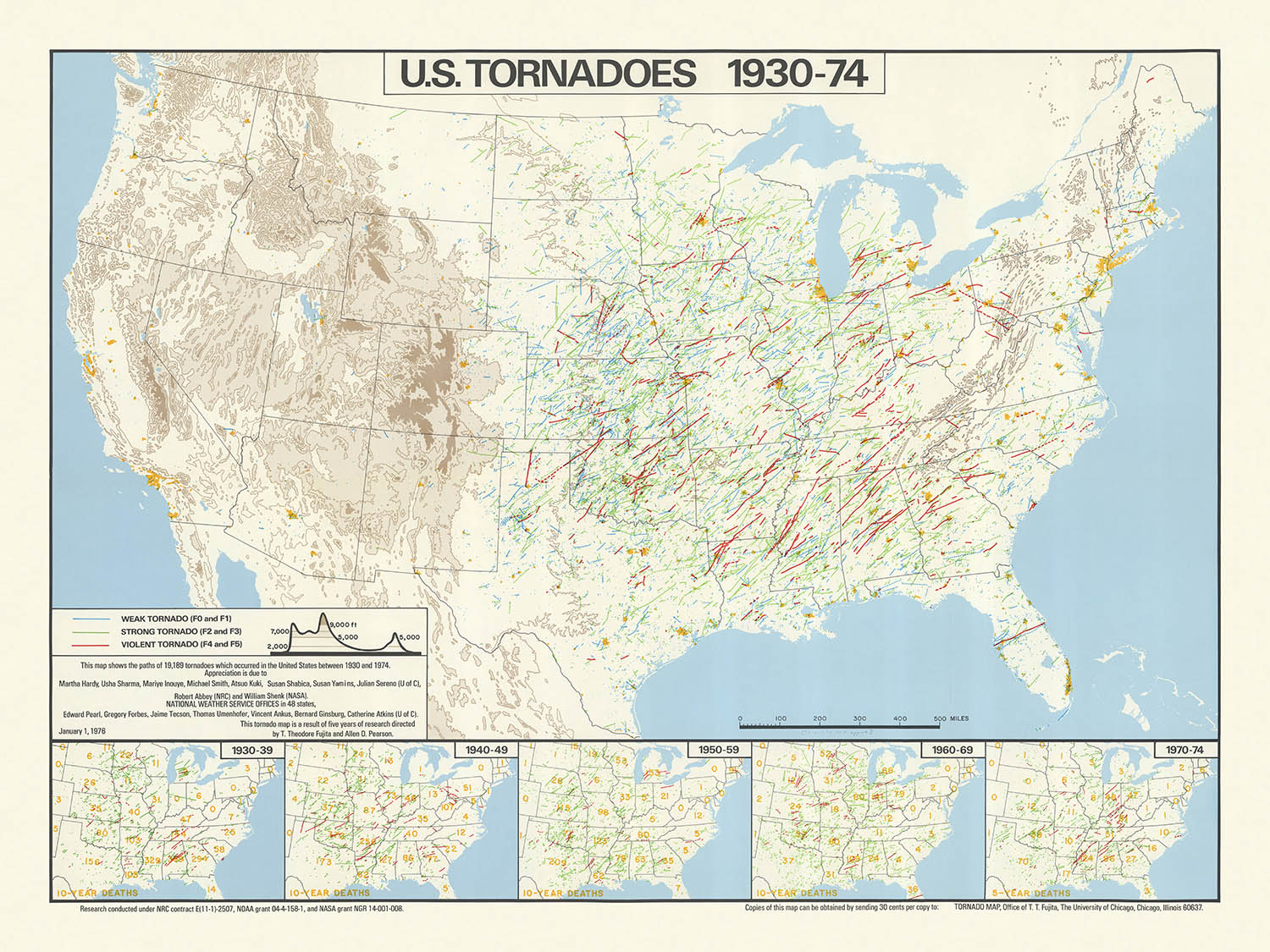
Cette carte thématique remarquable, intitulée "Tornades aux États-Unis, 1930-74," offre une chronique visuellement saisissante de près d'un demi-siècle d'activité tornadique à travers...
Continuer la lectureCette carte thématique remarquable, intitulée "Tornades aux États-Unis, 1930-74," offre une chronique visuellement saisissante de près d'un demi-siècle d'activité tornadique à travers les États-Unis contigus. Créée en 1974 par les éminents météorologues T. Theodore Fujita et Allen D. Pearson, la carte présente les trajectoires de 19 189 tornades, tissant une tapisserie dense et complexe de l'histoire météorologique. L'accent principal est mis sur la fréquence, la distribution et l'impact humain des tornades, rendant cette carte non seulement une réalisation cartographique mais aussi une déclaration profonde sur l'intersection des forces naturelles et des vies humaines.
Au cœur de cette carte se trouve une utilisation magistrale des techniques infographiques. Chaque trajectoire de tornade est soigneusement tracée, résultant en une concentration dramatique de lignes qui attire immédiatement l'œil vers le tristement célèbre "Tornado Alley" du centre des États-Unis. Le design de la carte équilibre élégamment clarté et densité, utilisant des caractéristiques de fond subtiles telles que les frontières des États, les grandes rivières et les Grands Lacs pour fournir une orientation sans distraire des données centrales. Cette approche reflète les meilleures traditions de la cartographie scientifique des années 1970, où fonction et forme sont harmonieusement entrelacées.
Ce qui élève véritablement cette carte est son intégration d'insets statistiques, qui chartent les décès liés aux tornades par décennie de 1930 à 1974. Ces cinq cartes inset fournissent un contrepoint sobre aux trajectoires tourbillonnantes des tornades, contextualisant le coût humain de ces catastrophes naturelles. L'inclusion de ces infographies transforme la carte d'un simple enregistrement d'événements météorologiques en une exploration nuancée du risque, de la résilience et de l'évolution de la sécurité publique face à l'imprévisibilité de la nature.
Les créateurs de la carte, T. Theodore Fujita et Allen D. Pearson, sont des figures légendaires dans le domaine de la recherche sur les intempéries. Fujita, en particulier, est renommé pour avoir développé l'échelle Fujita, qui reste un outil fondamental pour évaluer l'intensité des tornades. Leur collaboration sur cette carte lui confère non seulement une autorité scientifique mais marque également un moment clé dans l'histoire de la météorologie, alors que les chercheurs ont commencé à exploiter les données visuelles pour communiquer des modèles complexes et favoriser la compréhension du public.
Au-delà de sa valeur scientifique immédiate, cette carte se dresse comme un artefact culturel et historique. Elle capture une période de transformation dans la météorologie américaine, lorsque les avancées dans la collecte et l'analyse des données ont commencé à donner de nouveaux aperçus sur les modèles de temps extrême. Pour les collectionneurs, les historiens et les passionnés de météo, cette carte offre à la fois un instantané d'une époque déterminante et un témoignage du pouvoir durable de la cartographie pour éclairer les forces qui façonnent notre monde.
Endroits sur cette carte
- États-Unis d'Amérique (48 États contigus)
- Texas
- Oklahoma
- Kansas
- Nebraska
- Iowa
- Missouri
- Arkansas
- Illinois
- Indiana
- Ohio
- Rivière Mississippi
- Grands Lacs (Lac Supérieur, Lac Michigan, Lac Huron, Lac Érié, Lac Ontario)
- Montagnes Appalaches
- États du Sud-Est (par exemple, Alabama, Mississippi, Géorgie, Tennessee)
- Région des Grandes Plaines (Tornado Alley)
- États-Unis de l'Ouest (moins d'activité tornadique)
- États-Unis du Nord-Est (moins d'activité tornadique)
- Frontières des États (tous les États américains contigus)
- Divisions régionales des États-Unis (Midwest, Sud, Plaines, Sud-Est)
- Frontières avec le Canada et le Mexique
- Gulf of Mexico (limite sud)
- Océan Atlantique (limite est)
- Océan Pacifique (limite ouest, bien que ce ne soit pas le sujet principal)
- Cartes insérées montrant l'ensemble des États-Unis pour les statistiques de décès par décennie
Caractéristiques et monuments notables
- Clusters denses de chemins de tornades, en particulier dans le centre des États-Unis (Allée des Tornades)
- Chemins de tornades clairement marqués, chacun représentant un événement de tornade individuel
- Cinq cartes insérées, chacune décrivant les décès liés aux tornades par décennie (1930-39, 1940-49, 1950-59, 1960-69, 1970-74)
- Les grandes rivières, comme le fleuve Mississippi, sont représentées pour aider à l'orientation géographique
- Les Grands Lacs sont montrés comme des masses d'eau majeures
- Les montagnes Appalaches sont visibles, servant de référence géographique
- La légende de la carte explique les symboles et les lignes utilisés pour les chemins de tornades et les statistiques de décès
- Le titre de la carte et les crédits à T. Theodore Fujita et Allen D. Pearson sont affichés de manière proéminente
- La plus forte densité de chemins de tornades apparaît dans des États comme le Texas, l'Oklahoma, le Kansas, le Nebraska et l'Iowa
- Densité plus faible de chemins de tornades dans l'ouest et le nord-est des États-Unis
- Le sud-est des États-Unis montre également un nombre notable de chemins de tornades
- Les cartes insérées utilisent des ombres ou des points pour montrer le nombre de décès liés aux tornades par État ou région
- La carte utilise des couleurs contrastées ou des épaisseurs de ligne pour distinguer les chemins de tornades des autres caractéristiques
- Le design global est riche en données, soulignant la fréquence et la distribution des tornades
- La carte inclut une barre d'échelle pour référence
- Les chemins de tornades traversent parfois les frontières des États, illustrant la nature étendue de certaines tornades
- La carte est orientée avec le nord en haut, suivant les conventions cartographiques standard
Contexte historique et de design
- Nom de la carte : Tornades aux États-Unis, 1930-74
- Créée par T. Theodore Fujita et Allen D. Pearson en 1974
- Carte infographique thématique, se concentrant sur les occurrences de tornades aux États-Unis
- Visualise les chemins de 19 189 tornades survenues aux États-Unis entre 1930 et 1974
- Inclut des insets montrant les décès liés aux tornades pour cinq décennies différentes : 1930-39, 1940-49, 1950-59, 1960-69 et 1970-74
- L'échelle de la carte est d'environ 1:6 000 000
- Cartographes : T. Theodore Fujita, un météorologue pionnier connu pour avoir développé l'échelle Fujita (échelle F) pour l'intensité des tornades, et Allen D. Pearson, une figure notable dans la recherche sur les intempéries
- Publiée en 1974, peu après le dévastateur Super Outbreak de 1974, l'une des plus grandes épidémies de tornades de l'histoire des États-Unis
- La carte est le produit d'une période où la documentation et la recherche sur les tornades devenaient plus systématiques, avec une utilisation accrue des données météorologiques
- Fournit un résumé visuel unique de plus de quatre décennies d'activité tornadique, soulignant la fréquence et la distribution des chemins de tornades
- Thématiquement, la carte aborde les dangers naturels, spécifiquement les tornades, et leur impact sur la vie humaine
- Les cartes insérées donnent un précieux contexte historique sur les schémas changeants des décès liés aux tornades au fil du temps
- La carte a probablement servi d'outil de recherche et de ressource de sensibilisation du public durant une période d'intérêt croissant pour la préparation aux catastrophes
- Le design utilise des lignes denses et superposées pour représenter les chemins de tornades, transmettant visuellement la concentration de l'activité tornadique dans certaines régions
- Met en évidence la région de "Tornado Alley" au centre des États-Unis, connue pour sa haute fréquence de tornades
- Réflète l'état de la science météorologique et de la collecte de données au milieu du 20ème siècle
- La création de la carte reflète une collaboration croissante entre météorologues et cartographes pour la communication publique
- Importance historique : représente l'une des premières visualisations complètes des données sur les tornades aux États-Unis.
- La période des données (1930-1974) inclut des avancées technologiques et méthodologiques significatives dans l'observation météorologique
- La carte fournit une base pour comparer l'activité des tornades avant et après la mise en œuvre des systèmes d'alerte modernes
- Elle sert de document historique, montrant l'évolution tant de la recherche sur les tornades que des efforts de sécurité publique
- La carte aurait contribué à la compréhension publique des risques de tornades et influencé les politiques et les codes de construction dans les zones sujettes aux tornades
- Le style de la carte est caractéristique des infographies des années 1970, avec un accent sur la clarté et la visualisation dense des données
- L'inclusion des statistiques de décès contextualise le coût humain des tornades, pas seulement leur fréquence
- La carte est un exemple précoce de cartographie thématique en météorologie, précédant l'adoption généralisée des SIG
- La publication de la carte par des chercheurs de premier plan sur les tornades lui confère une crédibilité scientifique supplémentaire
- L'approche infographique rend les données météorologiques complexes accessibles à un public plus large
- Le focus de la carte sur les États-Unis reflète la vulnérabilité unique du pays aux tornades en raison de sa géographie et de son climat
- La carte n'inclut pas l'Alaska, Hawaï ou les territoires américains, se concentrant uniquement sur les États contigus
Veuillez vérifier les images pour vous assurer qu'une ville ou un endroit spécifique est montré sur cette carte. Vous pouvez également nous contacter et nous demander de vérifier la carte pour vous.
Cette carte est magnifique à toutes les tailles, mais je recommande toujours d'opter pour une taille plus grande si vous avez de l'espace. De cette façon, vous pouvez facilement distinguer tous les détails.
Cette carte est incroyable à des tailles allant jusqu'à 90in (230cm). Si vous recherchez une carte plus grande, veuillez nous contacter.
Le modèle dans les images de la liste tient la version de cette carte de 18x24in (45x60cm).
La cinquième image de la liste montre un exemple de mon service de personnalisation de carte.
Si vous recherchez quelque chose de légèrement différent, consultez ma collection des meilleures anciennes cartes pour voir si quelque chose d'autre attire votre attention.
Veuillez me contacter pour vérifier si un certain emplacement, un point de repère ou une caractéristique est montré sur cette carte.
Cela ferait un merveilleux cadeau d'anniversaire, de Noël, pour la fête des pères, de départ au travail, d'anniversaire de mariage ou de pendaison de crémaillère pour quelqu'un des zones couvertes par cette carte.
Cette carte est disponible en tant qu'impression giclée sur papier mat d'archivage sans acide, ou vous pouvez l'acheter encadrée. Le cadre est un joli cadre noir simple qui convient à la plupart des esthétiques. Veuillez nous contacter si vous souhaitez une couleur ou un matériau de cadre différent. Mes cadres sont vitrées avec un acrylique de musée super clair (perspex/acrylite), qui est significativement moins réfléchissant que le verre, plus sûr, et arrivera toujours en parfait état.
This map is also available as a float framed canvas, sometimes known as a shadow gap framed canvas or canvas floater. The map is printed on artist's cotton canvas and then stretched over a handmade box frame. We then "float" the canvas inside a wooden frame, which is available in a range of colours (black, dark brown, oak, antique gold and white). This is a wonderful way to present a map without glazing in front. See some examples of float framed canvas maps and explore the differences between my different finishes.
For something truly unique, this map is also available in "Unique 3D", our trademarked process that dramatically transforms the map so that it has a wonderful sense of depth. We combine the original map with detailed topography and elevation data, so that mountains and the terrain really "pop". For more info and examples of 3D maps, check my Unique 3D page.
Cette carte thématique remarquable, intitulée "Tornades aux États-Unis, 1930-74," offre une chronique visuellement saisissante de près d'un demi-siècle d'activité tornadique à travers les États-Unis contigus. Créée en 1974 par les éminents météorologues T. Theodore Fujita et Allen D. Pearson, la carte présente les trajectoires de 19 189 tornades, tissant une tapisserie dense et complexe de l'histoire météorologique. L'accent principal est mis sur la fréquence, la distribution et l'impact humain des tornades, rendant cette carte non seulement une réalisation cartographique mais aussi une déclaration profonde sur l'intersection des forces naturelles et des vies humaines.
Au cœur de cette carte se trouve une utilisation magistrale des techniques infographiques. Chaque trajectoire de tornade est soigneusement tracée, résultant en une concentration dramatique de lignes qui attire immédiatement l'œil vers le tristement célèbre "Tornado Alley" du centre des États-Unis. Le design de la carte équilibre élégamment clarté et densité, utilisant des caractéristiques de fond subtiles telles que les frontières des États, les grandes rivières et les Grands Lacs pour fournir une orientation sans distraire des données centrales. Cette approche reflète les meilleures traditions de la cartographie scientifique des années 1970, où fonction et forme sont harmonieusement entrelacées.
Ce qui élève véritablement cette carte est son intégration d'insets statistiques, qui chartent les décès liés aux tornades par décennie de 1930 à 1974. Ces cinq cartes inset fournissent un contrepoint sobre aux trajectoires tourbillonnantes des tornades, contextualisant le coût humain de ces catastrophes naturelles. L'inclusion de ces infographies transforme la carte d'un simple enregistrement d'événements météorologiques en une exploration nuancée du risque, de la résilience et de l'évolution de la sécurité publique face à l'imprévisibilité de la nature.
Les créateurs de la carte, T. Theodore Fujita et Allen D. Pearson, sont des figures légendaires dans le domaine de la recherche sur les intempéries. Fujita, en particulier, est renommé pour avoir développé l'échelle Fujita, qui reste un outil fondamental pour évaluer l'intensité des tornades. Leur collaboration sur cette carte lui confère non seulement une autorité scientifique mais marque également un moment clé dans l'histoire de la météorologie, alors que les chercheurs ont commencé à exploiter les données visuelles pour communiquer des modèles complexes et favoriser la compréhension du public.
Au-delà de sa valeur scientifique immédiate, cette carte se dresse comme un artefact culturel et historique. Elle capture une période de transformation dans la météorologie américaine, lorsque les avancées dans la collecte et l'analyse des données ont commencé à donner de nouveaux aperçus sur les modèles de temps extrême. Pour les collectionneurs, les historiens et les passionnés de météo, cette carte offre à la fois un instantané d'une époque déterminante et un témoignage du pouvoir durable de la cartographie pour éclairer les forces qui façonnent notre monde.
Endroits sur cette carte
- États-Unis d'Amérique (48 États contigus)
- Texas
- Oklahoma
- Kansas
- Nebraska
- Iowa
- Missouri
- Arkansas
- Illinois
- Indiana
- Ohio
- Rivière Mississippi
- Grands Lacs (Lac Supérieur, Lac Michigan, Lac Huron, Lac Érié, Lac Ontario)
- Montagnes Appalaches
- États du Sud-Est (par exemple, Alabama, Mississippi, Géorgie, Tennessee)
- Région des Grandes Plaines (Tornado Alley)
- États-Unis de l'Ouest (moins d'activité tornadique)
- États-Unis du Nord-Est (moins d'activité tornadique)
- Frontières des États (tous les États américains contigus)
- Divisions régionales des États-Unis (Midwest, Sud, Plaines, Sud-Est)
- Frontières avec le Canada et le Mexique
- Gulf of Mexico (limite sud)
- Océan Atlantique (limite est)
- Océan Pacifique (limite ouest, bien que ce ne soit pas le sujet principal)
- Cartes insérées montrant l'ensemble des États-Unis pour les statistiques de décès par décennie
Caractéristiques et monuments notables
- Clusters denses de chemins de tornades, en particulier dans le centre des États-Unis (Allée des Tornades)
- Chemins de tornades clairement marqués, chacun représentant un événement de tornade individuel
- Cinq cartes insérées, chacune décrivant les décès liés aux tornades par décennie (1930-39, 1940-49, 1950-59, 1960-69, 1970-74)
- Les grandes rivières, comme le fleuve Mississippi, sont représentées pour aider à l'orientation géographique
- Les Grands Lacs sont montrés comme des masses d'eau majeures
- Les montagnes Appalaches sont visibles, servant de référence géographique
- La légende de la carte explique les symboles et les lignes utilisés pour les chemins de tornades et les statistiques de décès
- Le titre de la carte et les crédits à T. Theodore Fujita et Allen D. Pearson sont affichés de manière proéminente
- La plus forte densité de chemins de tornades apparaît dans des États comme le Texas, l'Oklahoma, le Kansas, le Nebraska et l'Iowa
- Densité plus faible de chemins de tornades dans l'ouest et le nord-est des États-Unis
- Le sud-est des États-Unis montre également un nombre notable de chemins de tornades
- Les cartes insérées utilisent des ombres ou des points pour montrer le nombre de décès liés aux tornades par État ou région
- La carte utilise des couleurs contrastées ou des épaisseurs de ligne pour distinguer les chemins de tornades des autres caractéristiques
- Le design global est riche en données, soulignant la fréquence et la distribution des tornades
- La carte inclut une barre d'échelle pour référence
- Les chemins de tornades traversent parfois les frontières des États, illustrant la nature étendue de certaines tornades
- La carte est orientée avec le nord en haut, suivant les conventions cartographiques standard
Contexte historique et de design
- Nom de la carte : Tornades aux États-Unis, 1930-74
- Créée par T. Theodore Fujita et Allen D. Pearson en 1974
- Carte infographique thématique, se concentrant sur les occurrences de tornades aux États-Unis
- Visualise les chemins de 19 189 tornades survenues aux États-Unis entre 1930 et 1974
- Inclut des insets montrant les décès liés aux tornades pour cinq décennies différentes : 1930-39, 1940-49, 1950-59, 1960-69 et 1970-74
- L'échelle de la carte est d'environ 1:6 000 000
- Cartographes : T. Theodore Fujita, un météorologue pionnier connu pour avoir développé l'échelle Fujita (échelle F) pour l'intensité des tornades, et Allen D. Pearson, une figure notable dans la recherche sur les intempéries
- Publiée en 1974, peu après le dévastateur Super Outbreak de 1974, l'une des plus grandes épidémies de tornades de l'histoire des États-Unis
- La carte est le produit d'une période où la documentation et la recherche sur les tornades devenaient plus systématiques, avec une utilisation accrue des données météorologiques
- Fournit un résumé visuel unique de plus de quatre décennies d'activité tornadique, soulignant la fréquence et la distribution des chemins de tornades
- Thématiquement, la carte aborde les dangers naturels, spécifiquement les tornades, et leur impact sur la vie humaine
- Les cartes insérées donnent un précieux contexte historique sur les schémas changeants des décès liés aux tornades au fil du temps
- La carte a probablement servi d'outil de recherche et de ressource de sensibilisation du public durant une période d'intérêt croissant pour la préparation aux catastrophes
- Le design utilise des lignes denses et superposées pour représenter les chemins de tornades, transmettant visuellement la concentration de l'activité tornadique dans certaines régions
- Met en évidence la région de "Tornado Alley" au centre des États-Unis, connue pour sa haute fréquence de tornades
- Réflète l'état de la science météorologique et de la collecte de données au milieu du 20ème siècle
- La création de la carte reflète une collaboration croissante entre météorologues et cartographes pour la communication publique
- Importance historique : représente l'une des premières visualisations complètes des données sur les tornades aux États-Unis.
- La période des données (1930-1974) inclut des avancées technologiques et méthodologiques significatives dans l'observation météorologique
- La carte fournit une base pour comparer l'activité des tornades avant et après la mise en œuvre des systèmes d'alerte modernes
- Elle sert de document historique, montrant l'évolution tant de la recherche sur les tornades que des efforts de sécurité publique
- La carte aurait contribué à la compréhension publique des risques de tornades et influencé les politiques et les codes de construction dans les zones sujettes aux tornades
- Le style de la carte est caractéristique des infographies des années 1970, avec un accent sur la clarté et la visualisation dense des données
- L'inclusion des statistiques de décès contextualise le coût humain des tornades, pas seulement leur fréquence
- La carte est un exemple précoce de cartographie thématique en météorologie, précédant l'adoption généralisée des SIG
- La publication de la carte par des chercheurs de premier plan sur les tornades lui confère une crédibilité scientifique supplémentaire
- L'approche infographique rend les données météorologiques complexes accessibles à un public plus large
- Le focus de la carte sur les États-Unis reflète la vulnérabilité unique du pays aux tornades en raison de sa géographie et de son climat
- La carte n'inclut pas l'Alaska, Hawaï ou les territoires américains, se concentrant uniquement sur les États contigus
Veuillez vérifier les images pour vous assurer qu'une ville ou un endroit spécifique est montré sur cette carte. Vous pouvez également nous contacter et nous demander de vérifier la carte pour vous.
Cette carte est magnifique à toutes les tailles, mais je recommande toujours d'opter pour une taille plus grande si vous avez de l'espace. De cette façon, vous pouvez facilement distinguer tous les détails.
Cette carte est incroyable à des tailles allant jusqu'à 90in (230cm). Si vous recherchez une carte plus grande, veuillez nous contacter.
Le modèle dans les images de la liste tient la version de cette carte de 18x24in (45x60cm).
La cinquième image de la liste montre un exemple de mon service de personnalisation de carte.
Si vous recherchez quelque chose de légèrement différent, consultez ma collection des meilleures anciennes cartes pour voir si quelque chose d'autre attire votre attention.
Veuillez me contacter pour vérifier si un certain emplacement, un point de repère ou une caractéristique est montré sur cette carte.
Cela ferait un merveilleux cadeau d'anniversaire, de Noël, pour la fête des pères, de départ au travail, d'anniversaire de mariage ou de pendaison de crémaillère pour quelqu'un des zones couvertes par cette carte.
Cette carte est disponible en tant qu'impression giclée sur papier mat d'archivage sans acide, ou vous pouvez l'acheter encadrée. Le cadre est un joli cadre noir simple qui convient à la plupart des esthétiques. Veuillez nous contacter si vous souhaitez une couleur ou un matériau de cadre différent. Mes cadres sont vitrées avec un acrylique de musée super clair (perspex/acrylite), qui est significativement moins réfléchissant que le verre, plus sûr, et arrivera toujours en parfait état.
This map is also available as a float framed canvas, sometimes known as a shadow gap framed canvas or canvas floater. The map is printed on artist's cotton canvas and then stretched over a handmade box frame. We then "float" the canvas inside a wooden frame, which is available in a range of colours (black, dark brown, oak, antique gold and white). This is a wonderful way to present a map without glazing in front. See some examples of float framed canvas maps and explore the differences between my different finishes.
For something truly unique, this map is also available in "Unique 3D", our trademarked process that dramatically transforms the map so that it has a wonderful sense of depth. We combine the original map with detailed topography and elevation data, so that mountains and the terrain really "pop". For more info and examples of 3D maps, check my Unique 3D page.
Many of our maps and art prints are chosen as thoughtful gifts for homes, offices, studies and meaningful places.
Choose a framed option for the easiest ready-to-hang gift, or choose an unframed print if the recipient may prefer to select their own frame.
We make orders locally in 23 countries around the world, so gifts can often be produced close to the recipient. This helps them arrive faster, travel more safely, and avoid customs or import duty surprises.
- We can deliver directly to the recipient
- Framed pieces arrive ready to hang
- Unframed prints are carefully packed in a strong protective tube
- Almost every order is made locally, for faster, safer gifting
- 90-day returns give the recipient time to decide
If you are not sure what to choose, please contact us. We can help you pick the right map, size, finish or delivery option.
Pour la plupart des commandes, le délai de livraison est d'environ 3 jours ouvrables. Les produits personnalisés et sur mesure prennent plus de temps, car je dois faire la personnalisation et vous l'envoyer pour approbation, ce qui prend généralement 1 ou 2 jours.
Veuillez noter que les grandes commandes encadrées prennent généralement plus de temps à réaliser et à livrer.
Si vous avez besoin que votre commande arrive à une date précise, veuillez me contacter avant de passer votre commande afin que nous puissions trouver le meilleur moyen de nous assurer que vous receviez votre commande à temps.
J'imprime et encadre des cartes et des œuvres d'art dans 23 pays à travers le monde. Cela signifie que votre commande sera réalisée localement, ce qui réduit le temps de livraison et garantit qu'elle ne sera pas endommagée pendant le transport. Vous ne paierez jamais de droits de douane ou d'importation, et nous mettrons moins de CO2 dans l'air.
Toutes mes cartes et impressions artistiques sont bien emballées et envoyées dans un tube robuste si non encadrées, ou entourées de mousse si encadrées.
J'essaie d'envoyer toutes les commandes dans les 1 ou 2 jours suivant la réception de votre commande, bien que certains produits (comme les masques, les mugs et les sacs fourre-tout) puissent prendre plus de temps à réaliser.
Si vous choisissez Livraison Express lors du paiement, nous donnerons la priorité à votre commande et l'enverrons par un service de messagerie de 1 jour (Fedex, DHL, UPS, Parcelforce).
La livraison le lendemain est également disponible dans certains pays (États-Unis, Royaume-Uni, Singapour, Émirats Arabes Unis), mais veuillez essayer de commander tôt dans la journée afin que nous puissions l'envoyer à temps.
Lisez mon guide complet sur la livraison et la production locale
Mon cadre standard est un cadre en bois dur noir de style galerie. Il est simple et a un aspect assez moderne. Mon cadre standard mesure environ 20 mm (0,8 po) de large.
J'utilise de l'acrylique super clair (perspex/acrylite) pour le verre du cadre. C'est plus léger et plus sûr que le verre - et cela a meilleur aspect, car la réflexivité est plus faible.
Six couleurs de cadre standard sont disponibles gratuitement (noir, marron foncé, gris foncé, chêne, blanc et or antique). Des encadrements et montages/matelassages personnalisés sont disponibles si vous recherchez autre chose.
La plupart des cartes, œuvres d'art et illustrations sont également disponibles sous forme de toile encadrée. Nous utilisons une toile en coton mate (non brillante), que nous tendons sur un cadre en bois de boîte provenant de sources durables, puis nous 'flottions' la pièce à l'intérieur d'un cadre en bois. Le résultat final est assez beau, et il n'y a pas de vitrage qui gêne.
Tous les cadres sont fournis "prêts à accrocher", avec soit une corde, soit des supports à l'arrière. Les très grands cadres auront des plaques de suspension lourdes et/ou une latte de montage. Si vous avez des questions, veuillez nous contacter.
Voir quelques exemples de mes cartes encadrées et de cartes en toile encadrées.
Alternativement, je peux également fournir de vieilles cartes et œuvres d'art sur toile, sur panneau en mousse, en coton et d'autres matériaux.
Si vous souhaitez encadrer votre carte ou œuvre d'art vous-même, veuillez lire d'abord mon guide des tailles.
Mes cartes sont des reproductions de cartes originales de très haute qualité.
Je recherche des cartes originales et rares auprès de bibliothèques, de maisons de ventes aux enchères et de collections privées du monde entier, je les restaure dans mon atelier de Londres, puis j'utilise des encres et des imprimantes giclées spécialisées pour créer de magnifiques cartes encore plus belles que l'originale.
Mes cartes sont imprimées sur du papier d’archives mat (non brillant) sans acide qui semble de très haute qualité et ressemble presque à une carte. En termes techniques, le grammage/épaisseur du papier est de 10 mil/200 g/m². C'est parfait pour l'encadrement.
J’imprime avec des encres pigmentaires Epson ultrachrome giclée UV résistantes à la décoloration – certaines des meilleures encres que vous puissiez trouver.
je peux aussi faire cartes sur toile, chiffon en coton et autres matériaux exotiques.
En savoir plus sur Unique Maps Co..
Personnalisation de la carte
Si vous recherchez le cadeau parfait pour un anniversaire ou une pendaison de crémaillère, je peux personnaliser votre carte pour la rendre vraiment unique. Par exemple, je peux ajouter un court message, mettre en évidence un lieu important ou ajouter les armoiries de votre famille.
Les options sont presque infinies. S'il vous plaît voir mon page de personnalisation de la carte pour quelques merveilleux exemples de ce qui est possible.
Pour commander une carte personnalisée, sélectionnez « personnaliser votre carte » avant de l'ajouter à votre panier.
Entrer en contact si vous recherchez des personnalisations et des personnalisations plus complexes.
Vieillissement de la carte
Au fil des ans, des clients m'ont demandé des centaines de fois s'ils pouvaient acheter une carte qui semble uniforme. plus vieux.
Eh bien, vous pouvez désormais le faire en sélectionnant Aged avant d'ajouter une carte à votre panier.
Toutes les photos de produits que vous voyez sur cette page montrent la carte dans sa forme originale. Voilà à quoi ressemble la carte aujourd'hui.
Si vous sélectionnez Vieilli, je vieillirai votre carte à la main, en utilisant un processus spécial et unique développé au cours d'années d'étude de cartes anciennes, de discussions avec des chercheurs pour comprendre la chimie du vieillissement du papier, et bien sûr... beaucoup de pratique !
Si vous n'êtes pas sûr, respectez la couleur originale de la carte. Si vous voulez quelque chose d'un peu plus sombre et plus vieux à la recherche, optez pour Aged.
Si vous n'êtes pas satisfait de votre commande pour une raison quelconque, contactez-moi pour un remboursement sans conditions. Veuillez consulter notre politique de retours et de remboursements pour plus d'informations.
Je suis très confiant que vous aimerez votre carte restaurée ou votre impression artistique. Je fais cela depuis 1984. Je suis un vendeur Etsy 5 étoiles. J'ai vendu des dizaines de milliers de cartes et d'impressions artistiques et j'ai plus de 5 000 vrais avis 5 étoiles.
J'utilise un processus unique pour restaurer des cartes et des œuvres d'art qui est extrêmement chronophage et exigeant en main-d'œuvre. Trouver les cartes et illustrations originales peut prendre des mois. J'utilise une technologie de pointe et incroyablement coûteuse pour les numériser et les restaurer. En conséquence, je garantis que mes cartes et impressions artistiques sont d'une qualité supérieure - c'est pourquoi je peux offrir un remboursement sans conditions.
Presque toutes mes cartes et impressions artistiques ont l'air incroyables en grandes tailles (200 cm, 6,5 pieds+) et je peux également les encadrer et vous les livrer, via un transporteur spécial surdimensionné. Contactez-moi pour discuter de vos besoins spécifiques.
Or try searching for something!


