


Ancienne carte sphéroïdale de l'Europe et de l'Arctique par Garnier, 1860
L’offre du collectionneur
Choisissez deux œuvres éligibles et bénéficiez de 20 % de réduction sur les deux. Choisissez-en trois et celle au prix le plus bas est offerte, pour une économie maximale de 33 %.
Associez librement des cartes standard éligibles et des tirages d’art. Aucun code n’est requis ; l’offre est appliquée automatiquement lors du paiement.
Les configurations standard réalisées sur commande sont incluses. Les formats sur mesure, les créations personnalisées et les œuvres commissionnées sont exclus.
Besoin d’une livraison à différentes adresses ? Contactez-nous avant de commander.L’offre du collectionneur
Choisissez deux œuvres éligibles et bénéficiez de 20 % de réduction sur les deux. Choisissez-en trois et celle au prix le plus bas est offerte, pour une économie maximale de 33 %.
Associez librement des cartes standard éligibles et des tirages d’art. Aucun code n’est requis ; l’offre est appliquée automatiquement lors du paiement.
Les configurations standard réalisées sur commande sont incluses. Les formats sur mesure, les créations personnalisées et les œuvres commissionnées sont exclus.
Besoin d’une livraison à différentes adresses ? Contactez-nous avant de commander. Conçu à Londres Fabriqué en Canada
Conçu à Londres • Fabriqué en Canada
Conçu à Londres Fabriqué en Canada
Conçu à Londres • Fabriqué en Canada

Restaurée à partir de la carte originale de 1860 et imprimée en qualité musée. Lire l’histoire de cette carte
Choose your size
Choose your finish


(Plus d’infos)
Message cadeau & finition personnalisée

Si vous souhaitez ajouter un message cadeau, ou une finition (puzzle, panneau en aluminium, etc.) qui n'est pas disponible ici, veuillez le demander dans la "note de commande" lors de votre passage à la caisse.
Chaque commande est fabriquée sur mesure, donc si vous avez besoin d'ajuster légèrement la taille, ou d'imprimer sur un matériau inhabituel, faites-le nous savoir. Nous avons réalisé des milliers de commandes personnalisées au fil des ans, donc il n'y a (presque) rien que nous ne puissions gérer.
Vous pouvez également nous contacter avant de passer votre commande, si vous le souhaitez !

- Fabriqué localement. Livraison sûre
- Sans droits ni frais cachés
- Besoin d’aide ? Appelez-nous ou message WhatsApp
Own a piece of history
8,000+ five-star reviews


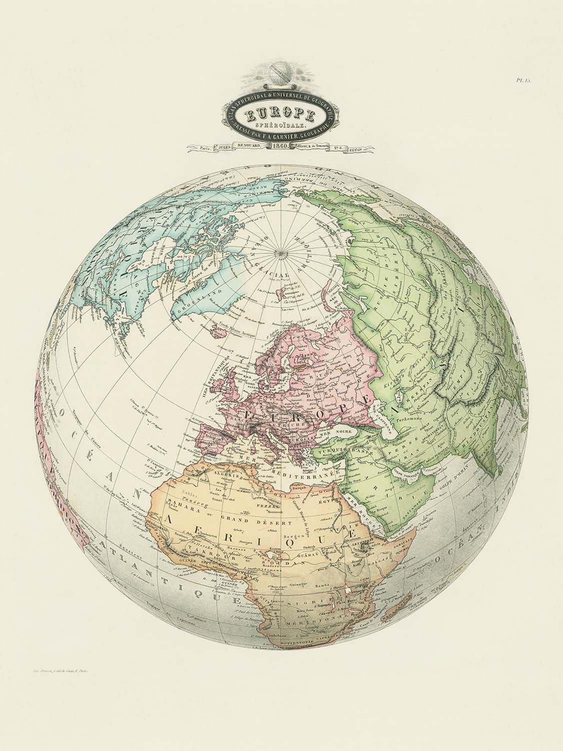
Entrez dans le monde raffiné de la cartographie du 19ème siècle avec "Europe Spheroidale", une carte exquise réalisée par le géographe réputé...
Continuer la lectureEntrez dans le monde raffiné de la cartographie du 19ème siècle avec "Europe Spheroidale", une carte exquise réalisée par le géographe réputé F. A. Garnier en 1860. Cet ouvrage remarquable, publié par V. Jules Renouard, témoigne de la curiosité scientifique et de la maîtrise artistique de son époque. L'attention méticuleuse de Garnier aux détails est évidente dans chaque aspect de la carte, de la précision de ses frontières à l'élégante coloration à la main qui donne vie au paysage politique de l'Europe et de ses régions voisines. Le titre original français de la carte, "Europe Spheroidale", reflète son thème central : une célébration de la nature sphérique de la Terre, un concept qui gagnait en appréciation à l'époque de l'exploration et de la découverte.
Au cœur de cette carte se trouve un récit visuel captivant qui s'étend au-delà de l'Europe, englobant l'Arctique, des parties de l'Afrique du Nord et de l'Asie occidentale. L'inclusion de ces régions offre une perspective large sur l'interconnexion des continents à une époque où les frontières et les empires étaient en mutation. Des rivières majeures comme le Danube et le Rhin, ainsi que des chaînes de montagnes emblématiques comme les Alpes et les Pyrénées, sont représentées avec clarté et précision, invitant le spectateur à retracer les caractéristiques naturelles qui ont façonné le cours de l'histoire. La délimitation soignée des frontières politiques fournit un aperçu fascinant du paysage géopolitique à la veille d'une transformation profonde.
Une caractéristique de l'art de Garnier est la cartouche décorative qui orne le haut de la carte, présentant un globe et l'inscription "Sphéricité de la terre." Cet embellissement élégant souligne non seulement l'esprit scientifique de la période mais ajoute également une touche de sophistication à la composition. Les détails colorés à la main rehaussent encore l'attrait visuel de la carte, chaque pays et région étant distingués par des teintes subtiles qui évoquent la grandeur des atlas anciens. La grille de lignes de latitude et de longitude témoigne de l'engagement de l'époque envers la précision et l'utilité navigatoire, rendant cette carte aussi fonctionnelle que belle.
Le design de la carte est un modèle de style cartographique du milieu du 19ème siècle, alliant art et rigueur empirique. L'étiquetage clair des mers, océans et formes de terre est complété par l'inclusion de régions à la fois familières et moins connues, telles que les îles britanniques, les péninsules ibérique et balkanique, et les confins de l'Empire ottoman. Cette approche globale reflète le dévouement de Garnier à fournir une vue holistique du monde, équilibrant les réalités politiques avec les caractéristiques durables du paysage naturel. La région arctique, affichée en haut, évoque la fascination de l'époque pour l'exploration et les mystères qui se trouvaient au-delà du monde connu.
Posséder "Europe Spheroidale" c'est détenir une pièce d'histoire—une fenêtre sur une époque où les frontières de la connaissance s'élargissaient aussi rapidement que les frontières sur la carte elle-même. Cette carte n'est pas simplement un document géographique ; c'est une œuvre d'art qui capture les valeurs intellectuelles et esthétiques de son époque. Qu'elle soit exposée dans un bureau, une bibliothèque ou une galerie, le chef-d'œuvre de Garnier offre à la fois une déclaration visuelle frappante et une riche source d'insights historiques, en faisant un ajout essentiel à toute collection discernante de cartes anciennes.
Pays et régions sur cette carte
- Europe
- Région arctique
- Afrique du Nord
- Asie occidentale
- Scandinavie
- Îles britanniques
- Péninsule ibérique
- Péninsule italienne
- Péninsule des Balkans
- Europe de l'Est
- Europe centrale
- Europe de l'Ouest
- Russie (partie européenne)
- Empire ottoman (parties européenne et asiatique)
- France
- Espagne
- Portugal
- Italie
- Allemagne (différents États et principautés)
- Autriche (Empire autrichien)
- Suisse
- Pays-Bas
- Belgique
- Danemark
- Suède
- Norvège
- Grèce
- Turquie (Empire ottoman)
- Égypte (partiellement visible)
- Algérie (partiellement visible)
- Maroc (partiellement visible)
- Tunisie (partiellement visible)
Caractéristiques et monuments notables
- Cartouche décoratif en haut avec illustration de globe et inscription "Sphéricité de la terre."
- Limites politiques clairement délimitées, mises en évidence par un coloriage à la main.
- Étiquetage détaillé des mers et océans, tels que la mer Méditerranée, l'océan Atlantique et l'océan Arctique.
- Chaînes de montagnes proéminentes, y compris les Alpes et les Pyrénées clairement étiquetées.
- Région arctique affichée en évidence en haut de la carte.
- Étiquetage détaillé des grandes rivières et des plans d'eau, tels que le Danube, le Rhin et la mer Noire.
- Lignes de latitude et de longitude clairement marquées, soulignant l'exactitude scientifique et l'utilité navigatoire.
- Inclusion de parties de l'Afrique du Nord et de l'Asie occidentale, clairement étiquetées et colorées.
Contexte historique et de design
- Créé par F. A. Garnier, un géographe connu pour ses œuvres cartographiques détaillées et scientifiquement informées.
- Publié par V. Jules Renouard en 1860.
- Carte politique détaillée et coloriée à la main, typique de l'art cartographique du milieu du 19e siècle, mettant l'accent sur la clarté, la précision et l'attrait esthétique.
- Réflète l'esprit scientifique et exploratoire du 19e siècle, fournissant des aperçus sur les frontières géopolitiques et les connaissances géographiques de l'époque.
- Concentré principalement sur l'Europe, mais inclut également les régions environnantes telles que des parties de l'Afrique, de l'Asie et de la région arctique.
- Comprend un cartouche décoratif en haut avec une illustration de globe, soulignant la forme sphérique de la Terre.
- Fournit un aperçu fascinant du paysage géopolitique à la veille d'une profonde transformation.
Veuillez vérifier les images pour vous assurer qu'une ville ou un lieu spécifique est montré sur cette carte. Vous pouvez également nous contacter et demander de vérifier la carte pour vous.
Cette carte a fière allure à toutes les tailles, mais je recommande toujours d'opter pour une taille plus grande si vous avez de l'espace. De cette façon, vous pouvez facilement distinguer tous les détails.
Cette carte est incroyable jusqu'à des tailles allant jusqu'à 70 pouces (180 cm). Si vous recherchez une carte plus grande, veuillez nous contacter.
Le modèle dans les images de la liste tient la version 18x24 pouces (45x60 cm) de cette carte.
La cinquième image de la liste montre un exemple de mon service de personnalisation de carte.
Si vous recherchez quelque chose de légèrement différent, consultez ma collection des meilleures anciennes cartes pour voir si quelque chose d'autre attire votre attention.
Veuillez me contacter pour vérifier si un certain emplacement, monument ou caractéristique est montré sur cette carte.
Cela ferait un merveilleux cadeau d'anniversaire, de Noël, pour la fête des pères, pour un départ au travail, un anniversaire de mariage ou une pendaison de crémaillère pour quelqu'un des régions couvertes par cette carte.
Cette carte est disponible en tant qu'impression giclée sur papier mat d'archives sans acide, ou vous pouvez l'acheter encadrée. Le cadre est un joli cadre noir simple qui convient à la plupart des esthétiques. Veuillez me contacter si vous souhaitez une couleur ou un matériau de cadre différent. Mes cadres sont vitrées avec un acrylique de musée super clair (perspex/acrylite), qui est significativement moins réfléchissant que le verre, plus sûr, et arrivera toujours en parfait état.
This map is also available as a float framed canvas, sometimes known as a shadow gap framed canvas or canvas floater. The map is printed on artist's cotton canvas and then stretched over a handmade box frame. We then "float" the canvas inside a wooden frame, which is available in a range of colours (black, dark brown, oak, antique gold and white). This is a wonderful way to present a map without glazing in front. See some examples of float framed canvas maps and explore the differences between my different finishes.
For something truly unique, this map is also available in "Unique 3D", our trademarked process that dramatically transforms the map so that it has a wonderful sense of depth. We combine the original map with detailed topography and elevation data, so that mountains and the terrain really "pop". For more info and examples of 3D maps, check my Unique 3D page.
Entrez dans le monde raffiné de la cartographie du 19ème siècle avec "Europe Spheroidale", une carte exquise réalisée par le géographe réputé F. A. Garnier en 1860. Cet ouvrage remarquable, publié par V. Jules Renouard, témoigne de la curiosité scientifique et de la maîtrise artistique de son époque. L'attention méticuleuse de Garnier aux détails est évidente dans chaque aspect de la carte, de la précision de ses frontières à l'élégante coloration à la main qui donne vie au paysage politique de l'Europe et de ses régions voisines. Le titre original français de la carte, "Europe Spheroidale", reflète son thème central : une célébration de la nature sphérique de la Terre, un concept qui gagnait en appréciation à l'époque de l'exploration et de la découverte.
Au cœur de cette carte se trouve un récit visuel captivant qui s'étend au-delà de l'Europe, englobant l'Arctique, des parties de l'Afrique du Nord et de l'Asie occidentale. L'inclusion de ces régions offre une perspective large sur l'interconnexion des continents à une époque où les frontières et les empires étaient en mutation. Des rivières majeures comme le Danube et le Rhin, ainsi que des chaînes de montagnes emblématiques comme les Alpes et les Pyrénées, sont représentées avec clarté et précision, invitant le spectateur à retracer les caractéristiques naturelles qui ont façonné le cours de l'histoire. La délimitation soignée des frontières politiques fournit un aperçu fascinant du paysage géopolitique à la veille d'une transformation profonde.
Une caractéristique de l'art de Garnier est la cartouche décorative qui orne le haut de la carte, présentant un globe et l'inscription "Sphéricité de la terre." Cet embellissement élégant souligne non seulement l'esprit scientifique de la période mais ajoute également une touche de sophistication à la composition. Les détails colorés à la main rehaussent encore l'attrait visuel de la carte, chaque pays et région étant distingués par des teintes subtiles qui évoquent la grandeur des atlas anciens. La grille de lignes de latitude et de longitude témoigne de l'engagement de l'époque envers la précision et l'utilité navigatoire, rendant cette carte aussi fonctionnelle que belle.
Le design de la carte est un modèle de style cartographique du milieu du 19ème siècle, alliant art et rigueur empirique. L'étiquetage clair des mers, océans et formes de terre est complété par l'inclusion de régions à la fois familières et moins connues, telles que les îles britanniques, les péninsules ibérique et balkanique, et les confins de l'Empire ottoman. Cette approche globale reflète le dévouement de Garnier à fournir une vue holistique du monde, équilibrant les réalités politiques avec les caractéristiques durables du paysage naturel. La région arctique, affichée en haut, évoque la fascination de l'époque pour l'exploration et les mystères qui se trouvaient au-delà du monde connu.
Posséder "Europe Spheroidale" c'est détenir une pièce d'histoire—une fenêtre sur une époque où les frontières de la connaissance s'élargissaient aussi rapidement que les frontières sur la carte elle-même. Cette carte n'est pas simplement un document géographique ; c'est une œuvre d'art qui capture les valeurs intellectuelles et esthétiques de son époque. Qu'elle soit exposée dans un bureau, une bibliothèque ou une galerie, le chef-d'œuvre de Garnier offre à la fois une déclaration visuelle frappante et une riche source d'insights historiques, en faisant un ajout essentiel à toute collection discernante de cartes anciennes.
Pays et régions sur cette carte
- Europe
- Région arctique
- Afrique du Nord
- Asie occidentale
- Scandinavie
- Îles britanniques
- Péninsule ibérique
- Péninsule italienne
- Péninsule des Balkans
- Europe de l'Est
- Europe centrale
- Europe de l'Ouest
- Russie (partie européenne)
- Empire ottoman (parties européenne et asiatique)
- France
- Espagne
- Portugal
- Italie
- Allemagne (différents États et principautés)
- Autriche (Empire autrichien)
- Suisse
- Pays-Bas
- Belgique
- Danemark
- Suède
- Norvège
- Grèce
- Turquie (Empire ottoman)
- Égypte (partiellement visible)
- Algérie (partiellement visible)
- Maroc (partiellement visible)
- Tunisie (partiellement visible)
Caractéristiques et monuments notables
- Cartouche décoratif en haut avec illustration de globe et inscription "Sphéricité de la terre."
- Limites politiques clairement délimitées, mises en évidence par un coloriage à la main.
- Étiquetage détaillé des mers et océans, tels que la mer Méditerranée, l'océan Atlantique et l'océan Arctique.
- Chaînes de montagnes proéminentes, y compris les Alpes et les Pyrénées clairement étiquetées.
- Région arctique affichée en évidence en haut de la carte.
- Étiquetage détaillé des grandes rivières et des plans d'eau, tels que le Danube, le Rhin et la mer Noire.
- Lignes de latitude et de longitude clairement marquées, soulignant l'exactitude scientifique et l'utilité navigatoire.
- Inclusion de parties de l'Afrique du Nord et de l'Asie occidentale, clairement étiquetées et colorées.
Contexte historique et de design
- Créé par F. A. Garnier, un géographe connu pour ses œuvres cartographiques détaillées et scientifiquement informées.
- Publié par V. Jules Renouard en 1860.
- Carte politique détaillée et coloriée à la main, typique de l'art cartographique du milieu du 19e siècle, mettant l'accent sur la clarté, la précision et l'attrait esthétique.
- Réflète l'esprit scientifique et exploratoire du 19e siècle, fournissant des aperçus sur les frontières géopolitiques et les connaissances géographiques de l'époque.
- Concentré principalement sur l'Europe, mais inclut également les régions environnantes telles que des parties de l'Afrique, de l'Asie et de la région arctique.
- Comprend un cartouche décoratif en haut avec une illustration de globe, soulignant la forme sphérique de la Terre.
- Fournit un aperçu fascinant du paysage géopolitique à la veille d'une profonde transformation.
Veuillez vérifier les images pour vous assurer qu'une ville ou un lieu spécifique est montré sur cette carte. Vous pouvez également nous contacter et demander de vérifier la carte pour vous.
Cette carte a fière allure à toutes les tailles, mais je recommande toujours d'opter pour une taille plus grande si vous avez de l'espace. De cette façon, vous pouvez facilement distinguer tous les détails.
Cette carte est incroyable jusqu'à des tailles allant jusqu'à 70 pouces (180 cm). Si vous recherchez une carte plus grande, veuillez nous contacter.
Le modèle dans les images de la liste tient la version 18x24 pouces (45x60 cm) de cette carte.
La cinquième image de la liste montre un exemple de mon service de personnalisation de carte.
Si vous recherchez quelque chose de légèrement différent, consultez ma collection des meilleures anciennes cartes pour voir si quelque chose d'autre attire votre attention.
Veuillez me contacter pour vérifier si un certain emplacement, monument ou caractéristique est montré sur cette carte.
Cela ferait un merveilleux cadeau d'anniversaire, de Noël, pour la fête des pères, pour un départ au travail, un anniversaire de mariage ou une pendaison de crémaillère pour quelqu'un des régions couvertes par cette carte.
Cette carte est disponible en tant qu'impression giclée sur papier mat d'archives sans acide, ou vous pouvez l'acheter encadrée. Le cadre est un joli cadre noir simple qui convient à la plupart des esthétiques. Veuillez me contacter si vous souhaitez une couleur ou un matériau de cadre différent. Mes cadres sont vitrées avec un acrylique de musée super clair (perspex/acrylite), qui est significativement moins réfléchissant que le verre, plus sûr, et arrivera toujours en parfait état.
This map is also available as a float framed canvas, sometimes known as a shadow gap framed canvas or canvas floater. The map is printed on artist's cotton canvas and then stretched over a handmade box frame. We then "float" the canvas inside a wooden frame, which is available in a range of colours (black, dark brown, oak, antique gold and white). This is a wonderful way to present a map without glazing in front. See some examples of float framed canvas maps and explore the differences between my different finishes.
For something truly unique, this map is also available in "Unique 3D", our trademarked process that dramatically transforms the map so that it has a wonderful sense of depth. We combine the original map with detailed topography and elevation data, so that mountains and the terrain really "pop". For more info and examples of 3D maps, check my Unique 3D page.
Many of our maps and art prints are chosen as thoughtful gifts for homes, offices, studies and meaningful places.
Choose a framed option for the easiest ready-to-hang gift, or choose an unframed print if the recipient may prefer to select their own frame.
We make orders locally in 23 countries around the world, so gifts can often be produced close to the recipient. This helps them arrive faster, travel more safely, and avoid customs or import duty surprises.
- We can deliver directly to the recipient
- Framed pieces arrive ready to hang
- Unframed prints are carefully packed in a strong protective tube
- Almost every order is made locally, for faster, safer gifting
- 90-day returns give the recipient time to decide
If you are not sure what to choose, please contact us. We can help you pick the right map, size, finish or delivery option.
Pour la plupart des commandes, le délai de livraison est d'environ 3 jours ouvrables. Les produits personnalisés et sur mesure prennent plus de temps, car je dois faire la personnalisation et vous l'envoyer pour approbation, ce qui prend généralement 1 ou 2 jours.
Veuillez noter que les grandes commandes encadrées prennent généralement plus de temps à réaliser et à livrer.
Si vous avez besoin que votre commande arrive à une date précise, veuillez me contacter avant de passer votre commande afin que nous puissions trouver le meilleur moyen de nous assurer que vous receviez votre commande à temps.
J'imprime et encadre des cartes et des œuvres d'art dans 23 pays à travers le monde. Cela signifie que votre commande sera réalisée localement, ce qui réduit le temps de livraison et garantit qu'elle ne sera pas endommagée pendant le transport. Vous ne paierez jamais de droits de douane ou d'importation, et nous mettrons moins de CO2 dans l'air.
Toutes mes cartes et impressions artistiques sont bien emballées et envoyées dans un tube robuste si non encadrées, ou entourées de mousse si encadrées.
J'essaie d'envoyer toutes les commandes dans les 1 ou 2 jours suivant la réception de votre commande, bien que certains produits (comme les masques, les mugs et les sacs fourre-tout) puissent prendre plus de temps à réaliser.
Si vous choisissez Livraison Express lors du paiement, nous donnerons la priorité à votre commande et l'enverrons par un service de messagerie de 1 jour (Fedex, DHL, UPS, Parcelforce).
La livraison le lendemain est également disponible dans certains pays (États-Unis, Royaume-Uni, Singapour, Émirats Arabes Unis), mais veuillez essayer de commander tôt dans la journée afin que nous puissions l'envoyer à temps.
Lisez mon guide complet sur la livraison et la production locale
Mon cadre standard est un cadre en bois dur noir de style galerie. Il est simple et a un aspect assez moderne. Mon cadre standard mesure environ 20 mm (0,8 po) de large.
J'utilise de l'acrylique super clair (perspex/acrylite) pour le verre du cadre. C'est plus léger et plus sûr que le verre - et cela a meilleur aspect, car la réflexivité est plus faible.
Six couleurs de cadre standard sont disponibles gratuitement (noir, marron foncé, gris foncé, chêne, blanc et or antique). Des encadrements et montages/matelassages personnalisés sont disponibles si vous recherchez autre chose.
La plupart des cartes, œuvres d'art et illustrations sont également disponibles sous forme de toile encadrée. Nous utilisons une toile en coton mate (non brillante), que nous tendons sur un cadre en bois de boîte provenant de sources durables, puis nous 'flottions' la pièce à l'intérieur d'un cadre en bois. Le résultat final est assez beau, et il n'y a pas de vitrage qui gêne.
Tous les cadres sont fournis "prêts à accrocher", avec soit une corde, soit des supports à l'arrière. Les très grands cadres auront des plaques de suspension lourdes et/ou une latte de montage. Si vous avez des questions, veuillez nous contacter.
Voir quelques exemples de mes cartes encadrées et de cartes en toile encadrées.
Alternativement, je peux également fournir de vieilles cartes et œuvres d'art sur toile, sur panneau en mousse, en coton et d'autres matériaux.
Si vous souhaitez encadrer votre carte ou œuvre d'art vous-même, veuillez lire d'abord mon guide des tailles.
Mes cartes sont des reproductions de cartes originales de très haute qualité.
Je recherche des cartes originales et rares auprès de bibliothèques, de maisons de ventes aux enchères et de collections privées du monde entier, je les restaure dans mon atelier de Londres, puis j'utilise des encres et des imprimantes giclées spécialisées pour créer de magnifiques cartes encore plus belles que l'originale.
Mes cartes sont imprimées sur du papier d’archives mat (non brillant) sans acide qui semble de très haute qualité et ressemble presque à une carte. En termes techniques, le grammage/épaisseur du papier est de 10 mil/200 g/m². C'est parfait pour l'encadrement.
J’imprime avec des encres pigmentaires Epson ultrachrome giclée UV résistantes à la décoloration – certaines des meilleures encres que vous puissiez trouver.
je peux aussi faire cartes sur toile, chiffon en coton et autres matériaux exotiques.
En savoir plus sur Unique Maps Co..
Personnalisation de la carte
Si vous recherchez le cadeau parfait pour un anniversaire ou une pendaison de crémaillère, je peux personnaliser votre carte pour la rendre vraiment unique. Par exemple, je peux ajouter un court message, mettre en évidence un lieu important ou ajouter les armoiries de votre famille.
Les options sont presque infinies. S'il vous plaît voir mon page de personnalisation de la carte pour quelques merveilleux exemples de ce qui est possible.
Pour commander une carte personnalisée, sélectionnez « personnaliser votre carte » avant de l'ajouter à votre panier.
Entrer en contact si vous recherchez des personnalisations et des personnalisations plus complexes.
Vieillissement de la carte
Au fil des ans, des clients m'ont demandé des centaines de fois s'ils pouvaient acheter une carte qui semble uniforme. plus vieux.
Eh bien, vous pouvez désormais le faire en sélectionnant Aged avant d'ajouter une carte à votre panier.
Toutes les photos de produits que vous voyez sur cette page montrent la carte dans sa forme originale. Voilà à quoi ressemble la carte aujourd'hui.
Si vous sélectionnez Vieilli, je vieillirai votre carte à la main, en utilisant un processus spécial et unique développé au cours d'années d'étude de cartes anciennes, de discussions avec des chercheurs pour comprendre la chimie du vieillissement du papier, et bien sûr... beaucoup de pratique !
Si vous n'êtes pas sûr, respectez la couleur originale de la carte. Si vous voulez quelque chose d'un peu plus sombre et plus vieux à la recherche, optez pour Aged.
Si vous n'êtes pas satisfait de votre commande pour une raison quelconque, contactez-moi pour un remboursement sans conditions. Veuillez consulter notre politique de retours et de remboursements pour plus d'informations.
Je suis très confiant que vous aimerez votre carte restaurée ou votre impression artistique. Je fais cela depuis 1984. Je suis un vendeur Etsy 5 étoiles. J'ai vendu des dizaines de milliers de cartes et d'impressions artistiques et j'ai plus de 5 000 vrais avis 5 étoiles.
J'utilise un processus unique pour restaurer des cartes et des œuvres d'art qui est extrêmement chronophage et exigeant en main-d'œuvre. Trouver les cartes et illustrations originales peut prendre des mois. J'utilise une technologie de pointe et incroyablement coûteuse pour les numériser et les restaurer. En conséquence, je garantis que mes cartes et impressions artistiques sont d'une qualité supérieure - c'est pourquoi je peux offrir un remboursement sans conditions.
Presque toutes mes cartes et impressions artistiques ont l'air incroyables en grandes tailles (200 cm, 6,5 pieds+) et je peux également les encadrer et vous les livrer, via un transporteur spécial surdimensionné. Contactez-moi pour discuter de vos besoins spécifiques.
Or try searching for something!


