


La taille comparative des lacs et des îles du monde, 1886: hémisphères nord et sud, Grands Lacs, mer Noire, etc.
L’offre du collectionneur
Choisissez deux œuvres éligibles et bénéficiez de 20 % de réduction sur les deux. Choisissez-en trois et celle au prix le plus bas est offerte, pour une économie maximale de 33 %.
Associez librement des cartes standard éligibles et des tirages d’art. Aucun code n’est requis ; l’offre est appliquée automatiquement lors du paiement.
Les configurations standard réalisées sur commande sont incluses. Les formats sur mesure, les créations personnalisées et les œuvres commissionnées sont exclus.
Besoin d’une livraison à différentes adresses ? Contactez-nous avant de commander.L’offre du collectionneur
Choisissez deux œuvres éligibles et bénéficiez de 20 % de réduction sur les deux. Choisissez-en trois et celle au prix le plus bas est offerte, pour une économie maximale de 33 %.
Associez librement des cartes standard éligibles et des tirages d’art. Aucun code n’est requis ; l’offre est appliquée automatiquement lors du paiement.
Les configurations standard réalisées sur commande sont incluses. Les formats sur mesure, les créations personnalisées et les œuvres commissionnées sont exclus.
Besoin d’une livraison à différentes adresses ? Contactez-nous avant de commander. Conçu à Londres Fabriqué en Canada
Conçu à Londres • Fabriqué en Canada
Conçu à Londres Fabriqué en Canada
Conçu à Londres • Fabriqué en Canada

Restaurée à partir de la carte originale de 1886 et imprimée en qualité musée. Lire l’histoire de cette carte
Choose your size
Choose your finish


(Plus d’infos)
Message cadeau & finition personnalisée

Si vous souhaitez ajouter un message cadeau, ou une finition (puzzle, panneau en aluminium, etc.) qui n'est pas disponible ici, veuillez le demander dans la "note de commande" lors de votre passage à la caisse.
Chaque commande est fabriquée sur mesure, donc si vous avez besoin d'ajuster légèrement la taille, ou d'imprimer sur un matériau inhabituel, faites-le nous savoir. Nous avons réalisé des milliers de commandes personnalisées au fil des ans, donc il n'y a (presque) rien que nous ne puissions gérer.
Vous pouvez également nous contacter avant de passer votre commande, si vous le souhaitez !

- Fabriqué localement. Livraison sûre
- Sans droits ni frais cachés
- Besoin d’aide ? Appelez-nous ou message WhatsApp
Own a piece of history
8,000+ five-star reviews


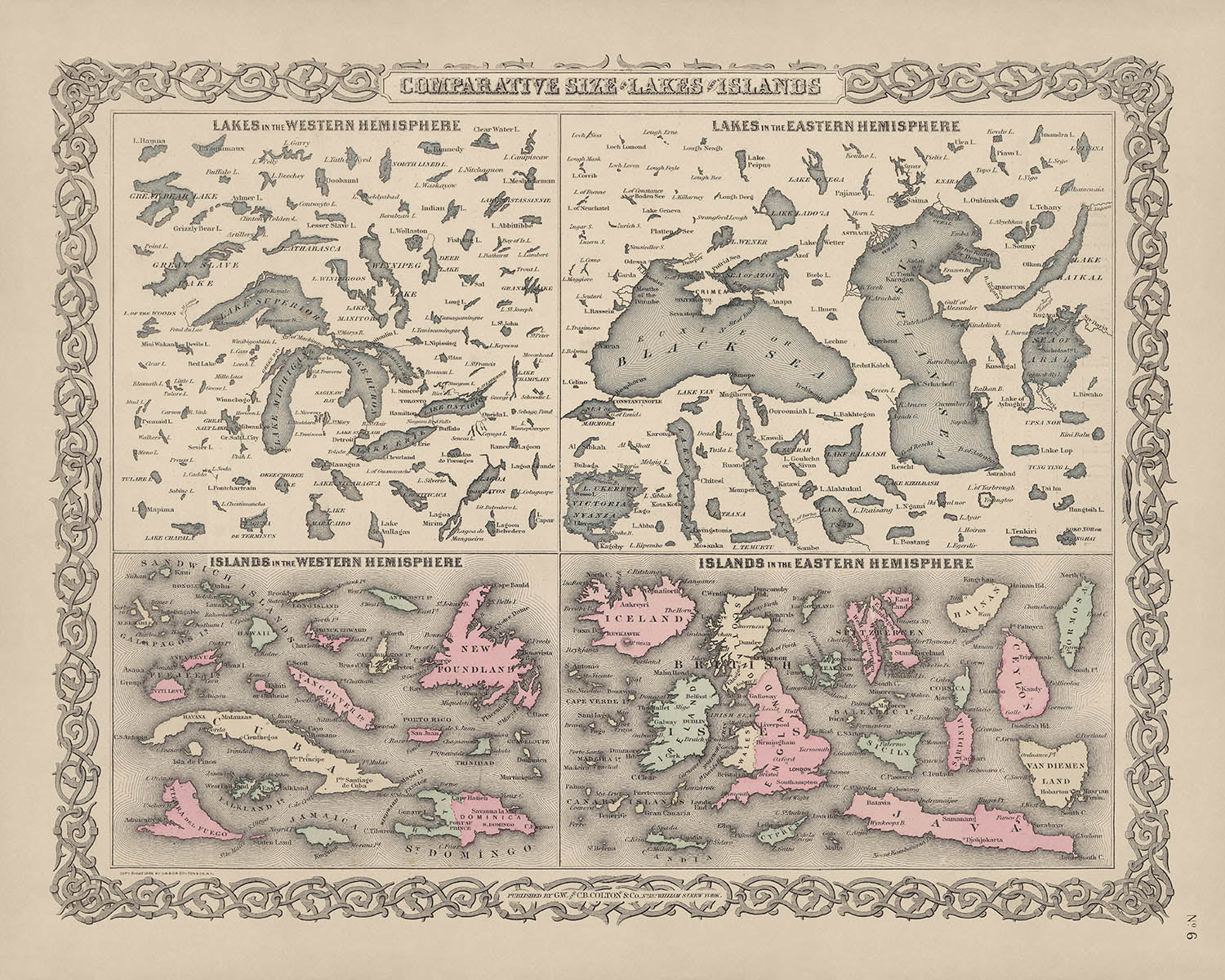
Entrez dans le monde de la maîtrise cartographique de la fin du 19e siècle avec "Taille comparative des lacs et des îles...
Continuer la lectureEntrez dans le monde de la maîtrise cartographique de la fin du 19e siècle avec "Taille comparative des lacs et des îles du monde", une carte extraordinaire publiée en 1886 par les estimés G.W. & C.B. Colton & Co. Cette œuvre captivante, créée à l'apogée de l'exploration mondiale et de la curiosité scientifique, offre une comparaison visuelle méticuleusement détaillée des plus grands lacs et îles de la planète. Chaque caractéristique est dessinée à l'échelle, invitant le spectateur à contempler les véritables proportions de ces merveilles naturelles—un rare plaisir tant pour le collectionneur chevronné que pour l'esprit intellectuellement curieux.
La société Colton, renommée pour sa précision et son art, était un pilier de la cartographie américaine dans les années 1800. Opérant depuis leur siège au 182 William Street à New York, les Colton étaient responsables de certains des atlas et cartes thématiques les plus influents de l'époque. Leur dévouement à l'exactitude et à l'excellence esthétique est évident dans chaque aspect de cette carte, de l'application soignée des couleurs à l'utilisation de hachures, une technique artistique qui apporte relief et profondeur au paysage. Cette carte se dresse comme un témoignage de leur héritage durable dans les annales de la cartographie.
Ce qui distingue cette carte est son approche innovante de l'éducation géographique. Plutôt que de se concentrer sur les frontières politiques ou les villes, elle présente un tableau mondial des lacs et îles les plus significatifs de la Terre, regroupés par hémisphère et rendus dans des couleurs harmonieuses. La carte met non seulement en valeur des géants familiers comme le Groenland, Bornéo et le lac Supérieur, mais elle met également en lumière des caractéristiques moins couramment représentées telles que le Grand Lac Salé riche en sel et le lac Mono. Chaque plan d'eau et masse terrestre est positionné pour faciliter une comparaison visuelle directe, rendant cette carte aussi intellectuellement stimulante que visuellement frappante.
Un aspect particulièrement fascinant de cette carte est son attention aux propriétés hydrologiques uniques de certains plans d'eau. La mer Noire et la mer Caspienne sont notées pour leurs niveaux de salinité distincts—environ la moitié et un tiers de celui de l'eau océanique, respectivement—tandis que la carte attire une attention particulière sur l'extrême salinité du Grand Lac Salé et du lac Mono. Cette attention à la diversité chimique des lacs du monde souligne le double rôle de la carte en tant que document scientifique et œuvre d'art, reflétant l'esprit d'enquête qui a défini la fin de l'ère victorienne.
Bien que la carte soit globale dans son ampleur, elle évite l'inclusion de villes, de villages ou de frontières politiques, offrant plutôt une célébration pure des formes naturelles de la Terre. De l'immense étendue glacée du Groenland aux contours luxuriants de Madagascar et au bleu profond du lac Baïkal, chaque caractéristique est présentée avec clarté et respect. Pour les collectionneurs, les historiens et les amoureux de la géographie, cette carte offre non seulement une fenêtre sur le monde physique tel qu'il était compris en 1886, mais aussi un morceau d'histoire cartographique qui incarne les réalisations intellectuelles et artistiques de son temps.
Villes et villages sur cette carte
- (Aucune ville ou village n'est étiqueté ou visible sur cette carte. La carte se concentre exclusivement sur les tailles comparatives des lacs et des îles et n'inclut pas de colonies.)
Caractéristiques et monuments notables
- Plans d'eau :
- Mer Caspienne (notée pour sa salinité d'environ un tiers de celle de l'eau océanique)
- Mer Noire (notée pour sa salinité d'environ la moitié de celle de l'eau océanique)
- Grand Lac Salé (très salé)
- Lac Mono (très salé)
- Lac Supérieur
- Lac Michigan
- Lac Huron
- Lac Érié
- Le lac Ontario
- Le lac Baïkal
- Le lac Victoria
- Le lac Tanganyika
- Le lac Nicaragua
- Le lac Titicaca
- Mer d'Aral
- Îles :
- Grande-Bretagne
- Cuba
- Islande
- Java
- Terre-Neuve
- Hainan
- Luzon
- Mindanao
- Irlande
- Tasmanie
- Sri Lanka (Ceylan)
- Sicile
- Sardaigne
- Corse
- Jamaïque
- Chypre
- Illustrations et éléments de design :
- Les îles et les lacs sont dessinés à l'échelle pour une comparaison visuelle directe.
- Différenciation claire entre les hémisphères (hémisphères nord et sud).
- Utilisation artistique de la couleur et des hachures pour fournir de la profondeur et de la clarté visuelle.
Contexte historique et de design
- Publié en 1886 par G.W. & C.B. Colton & Co., une société cartographique respectée basée à New York.
- Faisant partie d'un atlas de dernière édition, reflétant la compréhension géographique et les techniques cartographiques de la fin du 19e siècle.
- La carte compare visuellement les tailles des principaux lacs et îles à travers le monde, en se concentrant sur les deux hémisphères.
- Met en évidence les niveaux de salinité variables de certains lacs et mers, fournissant des informations éducatives sur les caractéristiques géographiques et hydrologiques.
- Rendu en couleur complète avec des techniques artistiques détaillées, y compris des hachures pour représenter le relief et la profondeur.
- Serait à la fois un outil éducatif et un artefact historique, apprécié par les collectionneurs, les historiens et les passionnés de géographie.
Veuillez vérifier les images pour vous assurer qu'une ville ou un endroit spécifique est montré sur cette carte. Vous pouvez également nous contacter et nous demander de vérifier la carte pour vous.
Cette carte a fière allure à toutes les tailles, mais je recommande toujours d'opter pour une taille plus grande si vous avez de l'espace. De cette façon, vous pouvez facilement distinguer tous les détails.
Cette carte est incroyable à des tailles allant jusqu'à 50 pouces (125 cm). Si vous recherchez une carte plus grande, veuillez nous contacter.
Le modèle dans les images de la liste tient la version 16x20 pouces (40x50 cm) de cette carte.
La cinquième image de la liste montre un exemple de mon service de personnalisation de carte.
Si vous recherchez quelque chose de légèrement différent, consultez ma collection des meilleures anciennes cartes pour voir si quelque chose d'autre attire votre attention.
Veuillez me contacter pour vérifier si un certain emplacement, monument ou caractéristique est montré sur cette carte.
Cela ferait un merveilleux cadeau d'anniversaire, de Noël, de la fête des pères, de départ au travail, d'anniversaire de mariage ou de pendaison de crémaillère pour quelqu'un des zones couvertes par cette carte.
Cette carte est disponible en tant qu'impression giclée sur papier mat d'archive sans acide, ou vous pouvez l'acheter encadrée. Le cadre est un joli cadre noir simple qui convient à la plupart des esthétiques. Veuillez nous contacter si vous souhaitez une couleur ou un matériau de cadre différent. Mes cadres sont en verre acrylique super clair de qualité muséale (perspex/acrylite), qui est significativement moins réfléchissant que le verre, plus sûr, et arrivera toujours en parfait état.
This map is also available as a float framed canvas, sometimes known as a shadow gap framed canvas or canvas floater. The map is printed on artist's cotton canvas and then stretched over a handmade box frame. We then "float" the canvas inside a wooden frame, which is available in a range of colours (black, dark brown, oak, antique gold and white). This is a wonderful way to present a map without glazing in front. See some examples of float framed canvas maps and explore the differences between my different finishes.
For something truly unique, this map is also available in "Unique 3D", our trademarked process that dramatically transforms the map so that it has a wonderful sense of depth. We combine the original map with detailed topography and elevation data, so that mountains and the terrain really "pop". For more info and examples of 3D maps, check my Unique 3D page.
Entrez dans le monde de la maîtrise cartographique de la fin du 19e siècle avec "Taille comparative des lacs et des îles du monde", une carte extraordinaire publiée en 1886 par les estimés G.W. & C.B. Colton & Co. Cette œuvre captivante, créée à l'apogée de l'exploration mondiale et de la curiosité scientifique, offre une comparaison visuelle méticuleusement détaillée des plus grands lacs et îles de la planète. Chaque caractéristique est dessinée à l'échelle, invitant le spectateur à contempler les véritables proportions de ces merveilles naturelles—un rare plaisir tant pour le collectionneur chevronné que pour l'esprit intellectuellement curieux.
La société Colton, renommée pour sa précision et son art, était un pilier de la cartographie américaine dans les années 1800. Opérant depuis leur siège au 182 William Street à New York, les Colton étaient responsables de certains des atlas et cartes thématiques les plus influents de l'époque. Leur dévouement à l'exactitude et à l'excellence esthétique est évident dans chaque aspect de cette carte, de l'application soignée des couleurs à l'utilisation de hachures, une technique artistique qui apporte relief et profondeur au paysage. Cette carte se dresse comme un témoignage de leur héritage durable dans les annales de la cartographie.
Ce qui distingue cette carte est son approche innovante de l'éducation géographique. Plutôt que de se concentrer sur les frontières politiques ou les villes, elle présente un tableau mondial des lacs et îles les plus significatifs de la Terre, regroupés par hémisphère et rendus dans des couleurs harmonieuses. La carte met non seulement en valeur des géants familiers comme le Groenland, Bornéo et le lac Supérieur, mais elle met également en lumière des caractéristiques moins couramment représentées telles que le Grand Lac Salé riche en sel et le lac Mono. Chaque plan d'eau et masse terrestre est positionné pour faciliter une comparaison visuelle directe, rendant cette carte aussi intellectuellement stimulante que visuellement frappante.
Un aspect particulièrement fascinant de cette carte est son attention aux propriétés hydrologiques uniques de certains plans d'eau. La mer Noire et la mer Caspienne sont notées pour leurs niveaux de salinité distincts—environ la moitié et un tiers de celui de l'eau océanique, respectivement—tandis que la carte attire une attention particulière sur l'extrême salinité du Grand Lac Salé et du lac Mono. Cette attention à la diversité chimique des lacs du monde souligne le double rôle de la carte en tant que document scientifique et œuvre d'art, reflétant l'esprit d'enquête qui a défini la fin de l'ère victorienne.
Bien que la carte soit globale dans son ampleur, elle évite l'inclusion de villes, de villages ou de frontières politiques, offrant plutôt une célébration pure des formes naturelles de la Terre. De l'immense étendue glacée du Groenland aux contours luxuriants de Madagascar et au bleu profond du lac Baïkal, chaque caractéristique est présentée avec clarté et respect. Pour les collectionneurs, les historiens et les amoureux de la géographie, cette carte offre non seulement une fenêtre sur le monde physique tel qu'il était compris en 1886, mais aussi un morceau d'histoire cartographique qui incarne les réalisations intellectuelles et artistiques de son temps.
Villes et villages sur cette carte
- (Aucune ville ou village n'est étiqueté ou visible sur cette carte. La carte se concentre exclusivement sur les tailles comparatives des lacs et des îles et n'inclut pas de colonies.)
Caractéristiques et monuments notables
- Plans d'eau :
- Mer Caspienne (notée pour sa salinité d'environ un tiers de celle de l'eau océanique)
- Mer Noire (notée pour sa salinité d'environ la moitié de celle de l'eau océanique)
- Grand Lac Salé (très salé)
- Lac Mono (très salé)
- Lac Supérieur
- Lac Michigan
- Lac Huron
- Lac Érié
- Le lac Ontario
- Le lac Baïkal
- Le lac Victoria
- Le lac Tanganyika
- Le lac Nicaragua
- Le lac Titicaca
- Mer d'Aral
- Îles :
- Grande-Bretagne
- Cuba
- Islande
- Java
- Terre-Neuve
- Hainan
- Luzon
- Mindanao
- Irlande
- Tasmanie
- Sri Lanka (Ceylan)
- Sicile
- Sardaigne
- Corse
- Jamaïque
- Chypre
- Illustrations et éléments de design :
- Les îles et les lacs sont dessinés à l'échelle pour une comparaison visuelle directe.
- Différenciation claire entre les hémisphères (hémisphères nord et sud).
- Utilisation artistique de la couleur et des hachures pour fournir de la profondeur et de la clarté visuelle.
Contexte historique et de design
- Publié en 1886 par G.W. & C.B. Colton & Co., une société cartographique respectée basée à New York.
- Faisant partie d'un atlas de dernière édition, reflétant la compréhension géographique et les techniques cartographiques de la fin du 19e siècle.
- La carte compare visuellement les tailles des principaux lacs et îles à travers le monde, en se concentrant sur les deux hémisphères.
- Met en évidence les niveaux de salinité variables de certains lacs et mers, fournissant des informations éducatives sur les caractéristiques géographiques et hydrologiques.
- Rendu en couleur complète avec des techniques artistiques détaillées, y compris des hachures pour représenter le relief et la profondeur.
- Serait à la fois un outil éducatif et un artefact historique, apprécié par les collectionneurs, les historiens et les passionnés de géographie.
Veuillez vérifier les images pour vous assurer qu'une ville ou un endroit spécifique est montré sur cette carte. Vous pouvez également nous contacter et nous demander de vérifier la carte pour vous.
Cette carte a fière allure à toutes les tailles, mais je recommande toujours d'opter pour une taille plus grande si vous avez de l'espace. De cette façon, vous pouvez facilement distinguer tous les détails.
Cette carte est incroyable à des tailles allant jusqu'à 50 pouces (125 cm). Si vous recherchez une carte plus grande, veuillez nous contacter.
Le modèle dans les images de la liste tient la version 16x20 pouces (40x50 cm) de cette carte.
La cinquième image de la liste montre un exemple de mon service de personnalisation de carte.
Si vous recherchez quelque chose de légèrement différent, consultez ma collection des meilleures anciennes cartes pour voir si quelque chose d'autre attire votre attention.
Veuillez me contacter pour vérifier si un certain emplacement, monument ou caractéristique est montré sur cette carte.
Cela ferait un merveilleux cadeau d'anniversaire, de Noël, de la fête des pères, de départ au travail, d'anniversaire de mariage ou de pendaison de crémaillère pour quelqu'un des zones couvertes par cette carte.
Cette carte est disponible en tant qu'impression giclée sur papier mat d'archive sans acide, ou vous pouvez l'acheter encadrée. Le cadre est un joli cadre noir simple qui convient à la plupart des esthétiques. Veuillez nous contacter si vous souhaitez une couleur ou un matériau de cadre différent. Mes cadres sont en verre acrylique super clair de qualité muséale (perspex/acrylite), qui est significativement moins réfléchissant que le verre, plus sûr, et arrivera toujours en parfait état.
This map is also available as a float framed canvas, sometimes known as a shadow gap framed canvas or canvas floater. The map is printed on artist's cotton canvas and then stretched over a handmade box frame. We then "float" the canvas inside a wooden frame, which is available in a range of colours (black, dark brown, oak, antique gold and white). This is a wonderful way to present a map without glazing in front. See some examples of float framed canvas maps and explore the differences between my different finishes.
For something truly unique, this map is also available in "Unique 3D", our trademarked process that dramatically transforms the map so that it has a wonderful sense of depth. We combine the original map with detailed topography and elevation data, so that mountains and the terrain really "pop". For more info and examples of 3D maps, check my Unique 3D page.
Many of our maps and art prints are chosen as thoughtful gifts for homes, offices, studies and meaningful places.
Choose a framed option for the easiest ready-to-hang gift, or choose an unframed print if the recipient may prefer to select their own frame.
We make orders locally in 23 countries around the world, so gifts can often be produced close to the recipient. This helps them arrive faster, travel more safely, and avoid customs or import duty surprises.
- We can deliver directly to the recipient
- Framed pieces arrive ready to hang
- Unframed prints are carefully packed in a strong protective tube
- Almost every order is made locally, for faster, safer gifting
- 90-day returns give the recipient time to decide
If you are not sure what to choose, please contact us. We can help you pick the right map, size, finish or delivery option.
Pour la plupart des commandes, le délai de livraison est d'environ 3 jours ouvrables. Les produits personnalisés et sur mesure prennent plus de temps, car je dois faire la personnalisation et vous l'envoyer pour approbation, ce qui prend généralement 1 ou 2 jours.
Veuillez noter que les grandes commandes encadrées prennent généralement plus de temps à réaliser et à livrer.
Si vous avez besoin que votre commande arrive à une date précise, veuillez me contacter avant de passer votre commande afin que nous puissions trouver le meilleur moyen de nous assurer que vous receviez votre commande à temps.
J'imprime et encadre des cartes et des œuvres d'art dans 23 pays à travers le monde. Cela signifie que votre commande sera réalisée localement, ce qui réduit le temps de livraison et garantit qu'elle ne sera pas endommagée pendant le transport. Vous ne paierez jamais de droits de douane ou d'importation, et nous mettrons moins de CO2 dans l'air.
Toutes mes cartes et impressions artistiques sont bien emballées et envoyées dans un tube robuste si non encadrées, ou entourées de mousse si encadrées.
J'essaie d'envoyer toutes les commandes dans les 1 ou 2 jours suivant la réception de votre commande, bien que certains produits (comme les masques, les mugs et les sacs fourre-tout) puissent prendre plus de temps à réaliser.
Si vous choisissez Livraison Express lors du paiement, nous donnerons la priorité à votre commande et l'enverrons par un service de messagerie de 1 jour (Fedex, DHL, UPS, Parcelforce).
La livraison le lendemain est également disponible dans certains pays (États-Unis, Royaume-Uni, Singapour, Émirats Arabes Unis), mais veuillez essayer de commander tôt dans la journée afin que nous puissions l'envoyer à temps.
Lisez mon guide complet sur la livraison et la production locale
Mon cadre standard est un cadre en bois dur noir de style galerie. Il est simple et a un aspect assez moderne. Mon cadre standard mesure environ 20 mm (0,8 po) de large.
J'utilise de l'acrylique super clair (perspex/acrylite) pour le verre du cadre. C'est plus léger et plus sûr que le verre - et cela a meilleur aspect, car la réflexivité est plus faible.
Six couleurs de cadre standard sont disponibles gratuitement (noir, marron foncé, gris foncé, chêne, blanc et or antique). Des encadrements et montages/matelassages personnalisés sont disponibles si vous recherchez autre chose.
La plupart des cartes, œuvres d'art et illustrations sont également disponibles sous forme de toile encadrée. Nous utilisons une toile en coton mate (non brillante), que nous tendons sur un cadre en bois de boîte provenant de sources durables, puis nous 'flottions' la pièce à l'intérieur d'un cadre en bois. Le résultat final est assez beau, et il n'y a pas de vitrage qui gêne.
Tous les cadres sont fournis "prêts à accrocher", avec soit une corde, soit des supports à l'arrière. Les très grands cadres auront des plaques de suspension lourdes et/ou une latte de montage. Si vous avez des questions, veuillez nous contacter.
Voir quelques exemples de mes cartes encadrées et de cartes en toile encadrées.
Alternativement, je peux également fournir de vieilles cartes et œuvres d'art sur toile, sur panneau en mousse, en coton et d'autres matériaux.
Si vous souhaitez encadrer votre carte ou œuvre d'art vous-même, veuillez lire d'abord mon guide des tailles.
Mes cartes sont des reproductions de cartes originales de très haute qualité.
Je recherche des cartes originales et rares auprès de bibliothèques, de maisons de ventes aux enchères et de collections privées du monde entier, je les restaure dans mon atelier de Londres, puis j'utilise des encres et des imprimantes giclées spécialisées pour créer de magnifiques cartes encore plus belles que l'originale.
Mes cartes sont imprimées sur du papier d’archives mat (non brillant) sans acide qui semble de très haute qualité et ressemble presque à une carte. En termes techniques, le grammage/épaisseur du papier est de 10 mil/200 g/m². C'est parfait pour l'encadrement.
J’imprime avec des encres pigmentaires Epson ultrachrome giclée UV résistantes à la décoloration – certaines des meilleures encres que vous puissiez trouver.
je peux aussi faire cartes sur toile, chiffon en coton et autres matériaux exotiques.
En savoir plus sur Unique Maps Co..
Personnalisation de la carte
Si vous recherchez le cadeau parfait pour un anniversaire ou une pendaison de crémaillère, je peux personnaliser votre carte pour la rendre vraiment unique. Par exemple, je peux ajouter un court message, mettre en évidence un lieu important ou ajouter les armoiries de votre famille.
Les options sont presque infinies. S'il vous plaît voir mon page de personnalisation de la carte pour quelques merveilleux exemples de ce qui est possible.
Pour commander une carte personnalisée, sélectionnez « personnaliser votre carte » avant de l'ajouter à votre panier.
Entrer en contact si vous recherchez des personnalisations et des personnalisations plus complexes.
Vieillissement de la carte
Au fil des ans, des clients m'ont demandé des centaines de fois s'ils pouvaient acheter une carte qui semble uniforme. plus vieux.
Eh bien, vous pouvez désormais le faire en sélectionnant Aged avant d'ajouter une carte à votre panier.
Toutes les photos de produits que vous voyez sur cette page montrent la carte dans sa forme originale. Voilà à quoi ressemble la carte aujourd'hui.
Si vous sélectionnez Vieilli, je vieillirai votre carte à la main, en utilisant un processus spécial et unique développé au cours d'années d'étude de cartes anciennes, de discussions avec des chercheurs pour comprendre la chimie du vieillissement du papier, et bien sûr... beaucoup de pratique !
Si vous n'êtes pas sûr, respectez la couleur originale de la carte. Si vous voulez quelque chose d'un peu plus sombre et plus vieux à la recherche, optez pour Aged.
Si vous n'êtes pas satisfait de votre commande pour une raison quelconque, contactez-moi pour un remboursement sans conditions. Veuillez consulter notre politique de retours et de remboursements pour plus d'informations.
Je suis très confiant que vous aimerez votre carte restaurée ou votre impression artistique. Je fais cela depuis 1984. Je suis un vendeur Etsy 5 étoiles. J'ai vendu des dizaines de milliers de cartes et d'impressions artistiques et j'ai plus de 5 000 vrais avis 5 étoiles.
J'utilise un processus unique pour restaurer des cartes et des œuvres d'art qui est extrêmement chronophage et exigeant en main-d'œuvre. Trouver les cartes et illustrations originales peut prendre des mois. J'utilise une technologie de pointe et incroyablement coûteuse pour les numériser et les restaurer. En conséquence, je garantis que mes cartes et impressions artistiques sont d'une qualité supérieure - c'est pourquoi je peux offrir un remboursement sans conditions.
Presque toutes mes cartes et impressions artistiques ont l'air incroyables en grandes tailles (200 cm, 6,5 pieds+) et je peux également les encadrer et vous les livrer, via un transporteur spécial surdimensionné. Contactez-moi pour discuter de vos besoins spécifiques.
Or try searching for something!


