


Vecchia mappa infografica dell'Australia, 1967: Agricoltura, Geologia, Occupazione, Clima, Acqua sotterranea, Commercio estero

-
![]() Handmade in Canada
Handmade in Canada
-
FREE worldwide delivery in 2-3 days ⓘ
Free delivery in 2-3 days
Your map should be delivered in 2-3 working days with free delivery, worldwide.
We make maps by hand locally in 23 countries, including Canada
![]() . If you're buying a gift for someone in another country, we will make the map locally to them.
. If you're buying a gift for someone in another country, we will make the map locally to them.You will never pay import tax or customs duty.
Express delivery is available at checkout which can reduce the delivery time to 1-2 days.
Please note that personalised maps, and larger framed maps, can take longer to produce and deliver.
If you need your order to arrive by a certain date, contact me and we can discuss your options.
-
90 day money back guarantee
ⓘ
90 giorni per restituire e ottenere un rimborso
I prodotti possono essere restituiti entro 90 giorni per un rimborso completo, o scambio con un altro prodotto.
Per articoli personalizzati o su misura, potremmo offrirti un credito in negozio o una carta regalo non scadente, poiché non possiamo rivendere ordini personalizzati.
Se hai domande, contattaci. Per ulteriori informazioni, consulta la nostra politica di restituzione e scambio.

My maps are rare, museum-grade, restored old maps sourced from libraries, auction houses and private collections across the globe.
Framing & free personalisation available
1. Select your size
2. Frame & personalise your map
Make your map unique with framing, hand-drawn customisation, vintage ageing, pop art text, unique 3D styling and moreGift message & custom finish

If you want to add a gift message, or a finish (jigsaw, aluminium board, etc.) that is not available here, please request it in the "order note" when you check out.
Every order is custom made, so if you need the size adjusted slightly, or printed on an unusual material, just let us know. We've done thousands of custom orders over the years, so there's (almost) nothing we can't manage.
You can also contact us before you order, if you prefer!

- Handmade locally. No import duty or tax
- FREE Delivery. Arrives in 2-3 days
- Love it or your money back
- Questions? WhatsApp me any time
Own a piece of history
5,000+ 5 star reviews


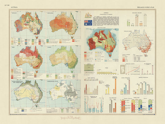
La mappa 'Australia in Infographics', un pezzo di arte cartografica meticolosamente realizzato, è stata creata dal Servizio Topografico dell'Esercito Polacco nell'anno 1967. In quanto mappa infografica, fonde magistralmente estetica visiva e rappresentazione dei dati, offrendo una prospettiva completa sulla terra giù in basso. La mappa è tematica, il che significa che enfatizza un tema o soggetto particolare all'interno di un'area geografica specifica, in questo caso, l'Australia. Questo stile di creazione di mappe, che si concentra su temi specifici, è stato un pilastro della rappresentazione geografica sin dal 17° secolo, consentendo uno studio dettagliato di singoli aspetti di una regione.
Questa particolare mappa non è solo una rappresentazione geografica dell'Australia, ma serve anche come un documento storico dello stato del paese a metà del 20° secolo. Presenta otto mappe e tredici grafici, ognuno meticolosamente realizzato per mostrare vari aspetti delle condizioni socio-economiche e ambientali dell'Australia durante quel periodo. Queste infografiche forniscono un'analisi approfondita dell'agricoltura, della popolazione, della geologia, della vegetazione, dei suoli, del clima, delle acque sotterranee, dei tipi di rilievo, dell'uso del suolo, dell'occupazione, dell'elettricità, del carbone, dell'industria e del commercio estero dell'Australia. Il valore di questi dati è immenso, offrendo intuizioni sullo sviluppo storico e sui modelli di crescita dell'Australia.
Il Servizio Topografico dell'Esercito Polacco, i creatori di questa mappa, erano rinomati per la loro attenzione ai dettagli e per la precisione. Le loro mappe non erano solo strumenti geografici, ma servivano anche come documenti storici, catturando l'essenza di una regione durante un periodo specifico. La mappa 'Australia in Infographics' è una testimonianza della loro esperienza, offrendo un'istantanea dell'Australia nel 1967 attraverso una combinazione di precisione cartografica e ingegnosità infografica.
La mappa 'Australia in Infographics' è più di una semplice mappa. È un artefatto storico, una finestra sul passato e una testimonianza dell'arte della cartografia. Le sue infografiche forniscono una ricchezza di informazioni, dipingendo un quadro vivido del paesaggio socio-economico e ambientale dell'Australia nel 1967. Pertanto, ha un valore immenso per storici, geografi e chiunque abbia interesse nella storia dell'Australia. La mappa serve come promemoria del potere della cartografia, non solo come strumento di navigazione, ma come mezzo per comprendere il nostro mondo e la sua storia.
- Contesto Storico
- Pubblicata nel 1967, la mappa cattura lo stato socio-economico e ambientale dell'Australia durante un periodo di significativa crescita e sviluppo.
-
La mappa fornisce intuizioni sul commercio estero dell'Australia a metà del 20° secolo, un periodo in cui il paese si stava affermando come un attore principale nell'economia globale.
-
Creatore della Mappa
- La mappa è stata creata dal Servizio Topografico dell'Esercito Polacco, noto per la loro precisione e attenzione ai dettagli.
-
Il loro approccio alla creazione di mappe unisce la cartografia tradizionale con le infografiche, fornendo una visione completa delle caratteristiche di una regione.
-
Dati Mostrati nella Mappa
- La mappa offre un'analisi approfondita dell'agricoltura dell'Australia, evidenziando la dipendenza del paese dall'agricoltura e dal bestiame durante gli anni '60.
- Fornisce una vista dettagliata della geologia dell'Australia, offrendo intuizioni sui paesaggi e le risorse naturali diversificate del paese.
- La mappa presenta le tendenze occupazionali, la produzione di elettricità, l'industria del carbone e altri aspetti della sua economia durante la metà del 20° secolo.
- Illustra anche il clima dell'Australia, le acque sotterranee, i tipi di rilievo e l'uso del suolo, fornendo una panoramica completa delle condizioni ambientali del paese.
Si prega di controllare attentamente le immagini per assicurarsi che una specifica città o luogo sia mostrato su questa mappa. Puoi anche contattarci e chiedere di controllare la mappa per te.
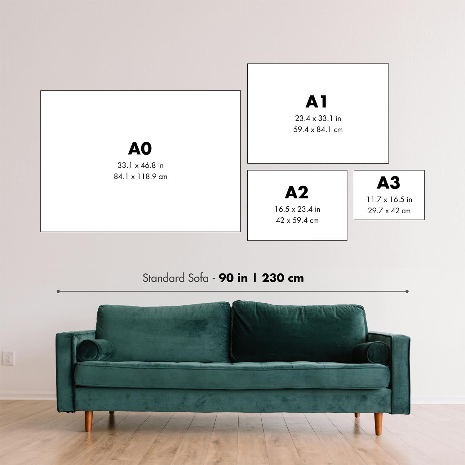
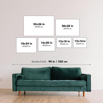
Questa mappa appare fantastica in tutte le dimensioni, ma consiglio sempre di optare per una dimensione più grande se hai spazio. In questo modo puoi facilmente distinguere tutti i dettagli.
Questa mappa appare incredibile in dimensioni fino a 50 pollici (125 cm). Se stai cercando una mappa più grande, per favore contattaci.
Il modello nelle immagini dell'annuncio tiene in mano la versione 18x24 pollici (45x60 cm) di questa mappa.
La quinta immagine dell'annuncio mostra un esempio del mio servizio di personalizzazione della mappa.
Se stai cercando qualcosa di leggermente diverso, dai un'occhiata alla mia collezione dei migliori mappe antiche per vedere se qualcosa attira la tua attenzione.
Per favore contattami per verificare se una certa posizione, punto di riferimento o caratteristica è mostrata su questa mappa.
Questo sarebbe un meraviglioso regalo di compleanno, Natale, Festa del Papà, addio al lavoro, anniversario o inaugurazione della casa per qualcuno delle aree coperte da questa mappa.
Questa mappa è disponibile come stampa giclée su carta opaca archiviata senza acidi, oppure puoi acquistarla incorniciata. La cornice è una semplice cornice nera che si adatta alla maggior parte degli stili. Per favore contattami se desideri un colore o materiale della cornice diverso. Le mie cornici sono dotate di un vetro acrilico super chiaro di grado museale (perspex/acrylite), che è significativamente meno riflettente del vetro, più sicuro e arriverà sempre in perfette condizioni.
This map is also available as a float framed canvas, sometimes known as a shadow gap framed canvas or canvas floater. The map is printed on artist's cotton canvas and then stretched over a handmade box frame. We then "float" the canvas inside a wooden frame, which is available in a range of colours (black, dark brown, oak, antique gold and white). This is a wonderful way to present a map without glazing in front. See some examples of float framed canvas maps and explore the differences between my different finishes.
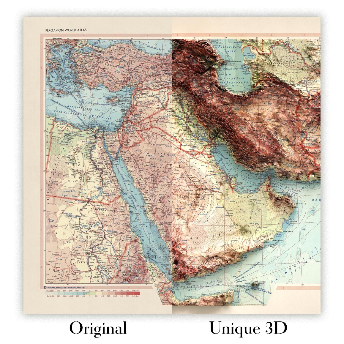
For something truly unique, this map is also available in "Unique 3D", our trademarked process that dramatically transforms the map so that it has a wonderful sense of depth. We combine the original map with detailed topography and elevation data, so that mountains and the terrain really "pop". For more info and examples of 3D maps, check my Unique 3D page.
For most orders, delivery time is about 3 working days. Personalised and customised products take longer, as I have to do the personalisation and send it to you for approval, which usually takes 1 or 2 days.
Please note that very large framed orders usually take longer to make and deliver.
If you need your order to arrive by a certain date, please contact me before you order so that we can find the best way of making sure you get your order in time.
I print and frame maps and artwork in 23 countries around the world. This means your order will be made locally, which cuts down on delivery time and ensures that it won't be damaged during delivery. You'll never pay customs or import duty, and we'll put less CO2 into the air.
All of my maps and art prints are well packaged and sent in a rugged tube if unframed, or surrounded by foam if framed.
I try to send out all orders within 1 or 2 days of receiving your order, though some products (like face masks, mugs and tote bags) can take longer to make.
If you select Express Delivery at checkout your order we will prioritise your order and send it out by 1-day courier (Fedex, DHL, UPS, Parcelforce).
Next Day delivery is also available in some countries (US, UK, Singapore, UAE) but please try to order early in the day so that we can get it sent out on time.
My standard frame is a gallery style black ash hardwood frame. It is simple and quite modern looking. My standard frame is around 20mm (0.8in) wide.
I use super-clear acrylic (perspex/acrylite) for the frame glass. It's lighter and safer than glass - and it looks better, as the reflectivity is lower.
Six standard frame colours are available for free (black, dark brown, dark grey, oak, white and antique gold). Custom framing and mounting/matting is available if you're looking for something else.
Most maps, art and illustrations are also available as a framed canvas. We use matte (not shiny) cotton canvas, stretch it over a sustainably sourced box wood frame, and then 'float' the piece within a wood frame. The end result is quite beautiful, and there's no glazing to get in the way.
All frames are provided "ready to hang", with either a string or brackets on the back. Very large frames will have heavy duty hanging plates and/or a mounting baton. If you have any questions, please get in touch.
See some examples of my framed maps and framed canvas maps.
Alternatively, I can also supply old maps and artwork on canvas, foam board, cotton rag and other materials.
If you want to frame your map or artwork yourself, please read my size guide first.
Alcune delle mie vecchie mappe sono ora disponibili come tele incorniciate. Per favore contattami se desideri ordinare una dimensione che non è disponibile nel mio negozio.
Le vecchie mappe su tela sono un'alternativa interessante alle mappe incorniciate in modo convenzionale. A seconda del tuo gusto personale e dell'arredamento della stanza, le mappe su tela possono "risaltare" un po' di più rispetto a una mappa incorniciata.
My maps are extremely high quality reproductions of original maps.
I source original, rare maps from libraries, auction houses and private collections around the world, restore them at my London workshop, and then use specialist giclée inks and printers to create beautiful maps that look even better than the original.
My maps are printed on acid-free archival matte (not glossy) paper that feels very high quality and almost like card. In technical terms the paper weight/thickness is 10mil/200gsm. It's perfect for framing.
I print with Epson ultrachrome giclée UV fade resistant pigment inks - some of the best inks you can find.
I can also make maps on canvas, cotton rag and other exotic materials.
Learn more about The Unique Maps Co.
Map personalisation
If you're looking for the perfect anniversary or housewarming gift, I can personalise your map to make it truly unique. For example, I can add a short message, or highlight an important location, or add your family's coat of arms.
The options are almost infinite. Please see my map personalisation page for some wonderful examples of what's possible.
To order a personalised map, select "personalise your map" before adding it to your basket.
Get in touch if you're looking for more complex customisations and personalisations.
Map ageing
I have been asked hundreds of times over the years by customers if they could buy a map that looks even older.
Well, now you can, by selecting Aged before you add a map to your basket.
All the product photos you see on this page show the map in its Original form. This is what the map looks like today.
If you select Aged, I will age your map by hand, using a special and unique process developed through years of studying old maps, talking to researchers to understand the chemistry of aging paper, and of course... lots of practice!
If you're unsure, stick to the Original colour of the map. If you want something a bit darker and older looking, go for Aged.
Se non sei soddisfatto del tuo ordine per qualsiasi motivo, contattami per un rimborso senza problemi. Si prega di consultare la nostra politica di reso e rimborso per ulteriori informazioni.
Sono molto sicuro che ti piacerà la tua mappa restaurata o la stampa d'arte. Lo faccio dal 1984. Sono un venditore Etsy a 5 stelle. Ho venduto decine di migliaia di mappe e stampe d'arte e ho oltre 5.000 recensioni reali a 5 stelle.
Utilizzo un processo unico per restaurare mappe e opere d'arte che richiede molto tempo e lavoro. Trovare le mappe e le illustrazioni originali può richiedere mesi. Utilizzo tecnologia all'avanguardia e incredibilmente costosa per scannerizzare e restaurarle. Di conseguenza, garantisco che le mie mappe e stampe d'arte siano superiori alle altre - ecco perché posso offrire un rimborso senza problemi.
Quasi tutte le mie mappe e stampe d'arte sembrano fantastiche a grandi dimensioni (200 cm, 6,5 piedi+) e posso anche incorniciarle e consegnarle a te, tramite un corriere speciale per oggetti di grandi dimensioni. Contattami per discutere delle tue esigenze specifiche.
Or try searching for something!


