

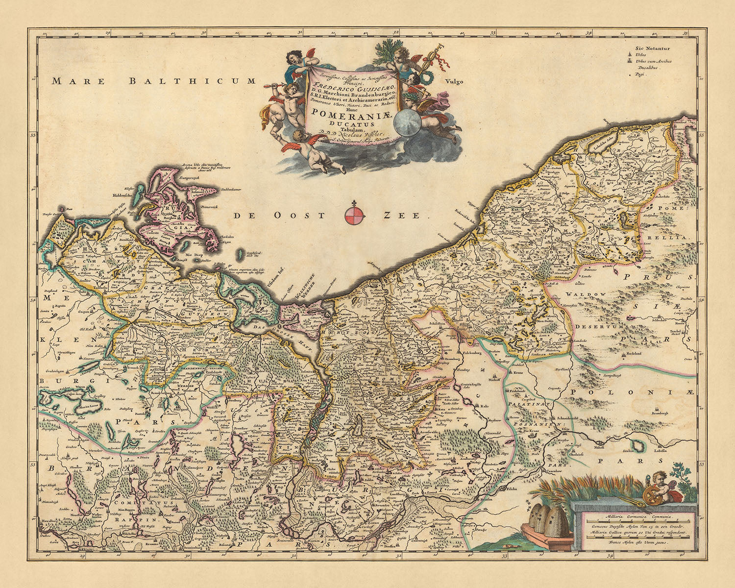


Antica mappa della Pomerania di Visscher, 1690: Słupsk, Szczecin, Piła, Koszalin, area di Drawsko
Spend $450, Save $90 Christmas Express Delivery available at checkout
Spend $450, Save $90

-
![]() Handmade in Canada
Handmade in Canada
-
FREE delivery in 3-4 days ⓘ
Free delivery in 3-4 days
Your map should be delivered in 3-4 working days with free delivery, worldwide.
Free delivery may arrive by Christmas, but Express Delivery at checkout is safer. Unframed orders have a better chance of arriving in time with free delivery.
New for 2025: After you order, you can send a beautiful gift preview by email, if you're worried it won't arrive on time.
We make maps by hand locally in 23 countries, including Canada
![]() . If you're buying a gift for someone in another country, we will make the map locally to them.
. If you're buying a gift for someone in another country, we will make the map locally to them.You will never pay import tax or customs duty.
Check the Christmas delivery guide for order deadlines. Delivery times are starting to slow down, and will continue to slow down towards Christmas.
Express delivery is available at checkout which can reduce the delivery time to 1-2 days.
Please note that personalised maps, and larger framed maps, can take longer to produce and deliver.
If you need your order to arrive by a certain date, contact me and we can discuss your options.
-
90 day money back guarantee
ⓘ
90 giorni per restituire e ricevere un rimborso
I prodotti possono essere restituiti entro 90 giorni per un rimborso completo, o cambio con un altro prodotto.
Per articoli personalizzati e su misura, potremmo offrirti un credito in negozio o una carta regalo non scadente, poiché non possiamo rivendere ordini personalizzati.
Se hai domande, contattaci. Per ulteriori informazioni, consulta la nostra politica di restituzione e cambio.

My maps are rare, museum-grade, restored old maps sourced from libraries, auction houses and private collections across the globe.
Framing & free personalisation available
1. Select your size
2. Frame & personalise your map
There is limited framing & personalisation capacity available. Order by 10am tomorrow for Christmas delivery.


Gift message & custom finish

If you want to add a gift message, or a finish (jigsaw, aluminium board, etc.) that is not available here, please request it in the "order note" when you check out.
Every order is custom made, so if you need the size adjusted slightly, or printed on an unusual material, just let us know. We've done thousands of custom orders over the years, so there's (almost) nothing we can't manage.
You can also contact us before you order, if you prefer!

- Handmade locally. No import duty or tax
- FREE Delivery by Christmas
- Love it or your money back (90 days)
- Questions? WhatsApp me any time
Own a piece of history
5,000+ 5 star reviews


Immergiti nel ricco arazzo della storia con questa mappa meticolosamente dettagliata della Pomerania, realizzata dal rinomato cartografo Nicolaes Visscher II nel 1690. Conosciuta come 'Pomeraniae ducatus tabulam' in latino, la mappa si traduce in 'Mappa del Ducato di Pomerania', che comprende l'area dell'attuale Polonia e Germania. La mappa offre un'affascinante panoramica delle divisioni geografiche e politiche dell'epoca, mostrando la grandezza dell'età dell'oro olandese della cartografia.
Città notevoli come Słupsk, Szczecin, Piła e Koszalin sono splendidamente rappresentate, ciascuna con le proprie caratteristiche uniche e significato storico. Słupsk, un importante centro commerciale nel XVII secolo, e Szczecin, una vitale città portuale sul fiume Oder, sono particolarmente impressionanti. Le città più piccole di Piła e Koszalin, sebbene meno prominenti, offrono uno sguardo dettagliato sul paesaggio più ampio della regione e sui modelli insediativi.
La mappa presenta anche l'Area Protetta del Paesaggio di Drawsko, una testimonianza della ricca biodiversità e bellezza naturale della regione. Questa area, nota per i suoi laghi e foreste incontaminate, aggiunge un ulteriore strato di contesto ambientale alla storia umana rappresentata sulla mappa. Serve a ricordare l'interazione duratura tra natura e civiltà, un tema che risuona in tutta la rappresentazione cartografica.
Oltre alle città e ai paesaggi naturali, la mappa rivela anche i confini politici del Ducato di Pomerania. La suddivisione della regione in unità amministrative più piccole, ciascuna con il proprio distintivo stemma, è una caratteristica affascinante che sottolinea la complessità politica dell'epoca. La mappa, quindi, non solo fornisce una panoramica geografica, ma serve anche come documento storico, riflettendo le dinamiche socio-politiche della fine del XVII secolo.
Alcuni dei luoghi significativi mostrati su questa mappa:
Città e paesi nel Ducato di Pomerania:
- Szczecin (Stettin): Conosciuta come la 'Parigi del Nord', era una grande città portuale e la capitale del Ducato di Pomerania.
- Słupsk (Stolp): Un importante centro di commercio e affari durante il XVII secolo.
- Koszalin (Köslin): Nota per il suo ricco patrimonio culturale e architettura storica.
- Piła (Schneidemühl): Un importante nodo ferroviario nella regione.
- Gdańsk (Danzig): Una delle città più ricche e grandi della Polonia e il principale porto marittimo.
- Gdynia (Gdingen): Nota per la sua industria cantieristica.
- Goleniów (Gollnow): Un importante centro dell'industria del legno.
- Kamień Pomorski (Cammin): Nota per la sua architettura in stile gotico.
- Swarzędz (Schwersenz): Famosa per la sua industria del mobile.
- Świnoujście (Swinemünde): Nota per le sue terme e centri benessere.
- Kołobrzeg (Kolberg): Famosa per il suo commercio di sale e come località di cura.
- Gryfino (Greifenhagen): Nota per il suo commercio di cereali.
- Stargard (Stargard in Pommern): Famosa per la sua industria tessile.
- Wałcz (Deutsch Krone): Nota per la sua industria della pelle.
- Choszczno (Arnswalde): Famosa per la sua industria della birra.
- Gryfice (Greifenberg): Nota per la sua industria della biancheria.
- Nowogard (Naugard): Famosa per la produzione di tessuti di lana.
Fenomeni Naturali e Luoghi di Interesse Notabili:
- Area Protetta del Paesaggio di Drawsko: Conosciuta per i suoi laghi e foreste incontaminati.
- Parco Nazionale di Wolin: Casa del più grande branco di bisonti europei in Polonia.
- Fiume Oder: Uno dei principali fiumi dell'Europa centrale.
- Parco Nazionale della Valle dell'Oder Inferiore: Conosciuto per il suo paesaggio di pianura alluvionale.
- Parco Nazionale di Jasmund: Famoso per le sue scogliere di gesso più grandi della Germania.
Eventi Storici Notabili (1600-1690):
- Guerra dei Trent'Anni (1618-1648): Questa guerra devastante ha colpito significativamente la regione, portando a cambiamenti nei confini politici e spostamenti di popolazione.
- Il Trattato di Stettino (1653): Questo trattato ha confermato la partizione del Ducato di Pomerania tra Brandeburgo-Prussia e Svezia.
- La Guerra di Scania (1675–1679): Questo conflitto ha portato a ulteriori cambiamenti territoriali nella regione.
Si prega di controllare attentamente le immagini per assicurarsi che una specifica città o luogo sia mostrato su questa mappa. Puoi anche contattarci e chiedere di controllare la mappa per te.
Questa mappa appare fantastica in tutte le dimensioni: 12x16in (30.5x41cm), 16x20in (40.5x51cm), 18x24in (45.5x61cm), 24x30in (61x76cm), 32x40in (81.5x102cm), 40x50in (102x127cm), 48x60in (122x153cm) e 56x70in (142x178cm), ma appare ancora meglio quando stampata in grande.
Posso creare bellissime stampe di grandi dimensioni di questa mappa fino a 90in (229cm). Si prega di contattarmi se si cercano opzioni di incorniciatura più grandi, personalizzate o diverse.
Il modello nelle immagini dell'elenco sta tenendo la versione 16x20in (40.5x51cm) di questa mappa.
La quinta immagine dell'elenco mostra un esempio del mio servizio di personalizzazione della mappa.
Se stai cercando qualcosa di leggermente diverso, dai un'occhiata alla mia collezione delle migliori mappe antiche d'Europa e delle città europee per vedere se qualcosa cattura la tua attenzione.
Si prega di contattarmi per verificare se una certa posizione, monumento o caratteristica è mostrata su questa mappa.
Questo sarebbe un meraviglioso regalo per un compleanno, Natale, Festa del Papà, addio al lavoro, anniversario o inaugurazione della casa per qualcuno delle aree coperte da questa mappa.
Questa mappa è disponibile come stampa giclée su carta opaca archiviabile senza acidi, oppure puoi acquistarla incorniciata. La cornice è una bella e semplice cornice nera che si adatta alla maggior parte degli stili. Ti preghiamo di contattarci se desideri un colore o un materiale diverso per la cornice. Le mie cornici sono rivestite con acrilico super chiaro di grado museo (perspex/acrylite), che è significativamente meno riflettente del vetro, più sicuro e arriverà sempre in perfette condizioni.
This map is also available as a float framed canvas, sometimes known as a shadow gap framed canvas or canvas floater. The map is printed on artist's cotton canvas and then stretched over a handmade box frame. We then "float" the canvas inside a wooden frame, which is available in a range of colours (black, dark brown, oak, antique gold and white). This is a wonderful way to present a map without glazing in front. See some examples of float framed canvas maps and explore the differences between my different finishes.
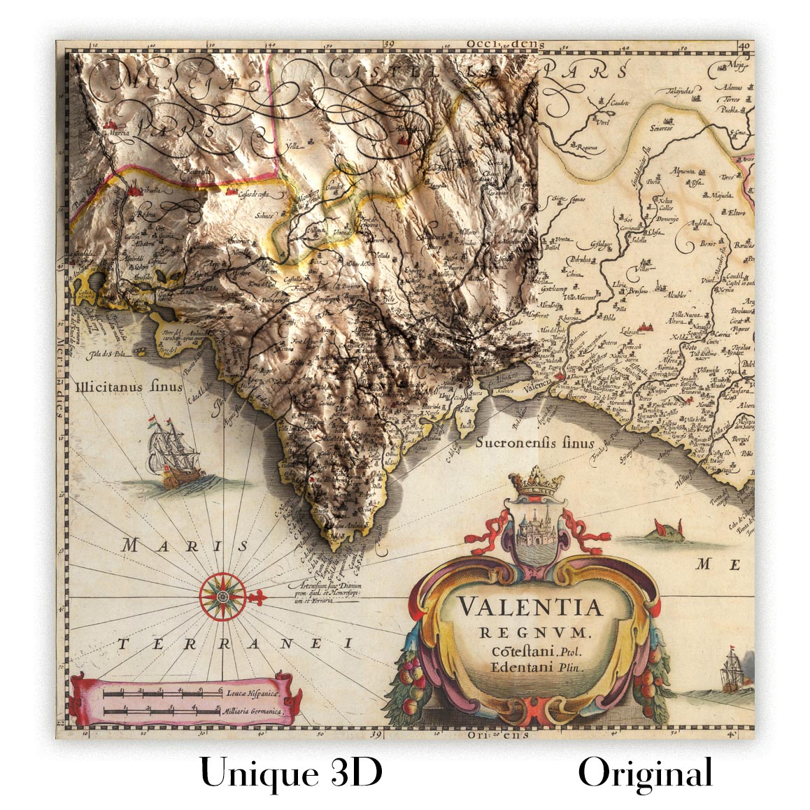
For something truly unique, this map is also available in "Unique 3D", our trademarked process that dramatically transforms the map so that it has a wonderful sense of depth. We combine the original map with detailed topography and elevation data, so that mountains and the terrain really "pop". For more info and examples of 3D maps, check my Unique 3D page.
For most orders, delivery time is about 3 working days. Personalised and customised products take longer, as I have to do the personalisation and send it to you for approval, which usually takes 1 or 2 days.
Please note that very large framed orders usually take longer to make and deliver.
If you need your order to arrive by a certain date, please contact me before you order so that we can find the best way of making sure you get your order in time.
I print and frame maps and artwork in 23 countries around the world. This means your order will be made locally, which cuts down on delivery time and ensures that it won't be damaged during delivery. You'll never pay customs or import duty, and we'll put less CO2 into the air.
All of my maps and art prints are well packaged and sent in a rugged tube if unframed, or surrounded by foam if framed.
I try to send out all orders within 1 or 2 days of receiving your order, though some products (like face masks, mugs and tote bags) can take longer to make.
If you select Express Delivery at checkout your order we will prioritise your order and send it out by 1-day courier (Fedex, DHL, UPS, Parcelforce).
Next Day delivery is also available in some countries (US, UK, Singapore, UAE) but please try to order early in the day so that we can get it sent out on time.
My standard frame is a gallery style black ash hardwood frame. It is simple and quite modern looking. My standard frame is around 20mm (0.8in) wide.
I use super-clear acrylic (perspex/acrylite) for the frame glass. It's lighter and safer than glass - and it looks better, as the reflectivity is lower.
Six standard frame colours are available for free (black, dark brown, dark grey, oak, white and antique gold). Custom framing and mounting/matting is available if you're looking for something else.
Most maps, art and illustrations are also available as a framed canvas. We use matte (not shiny) cotton canvas, stretch it over a sustainably sourced box wood frame, and then 'float' the piece within a wood frame. The end result is quite beautiful, and there's no glazing to get in the way.
All frames are provided "ready to hang", with either a string or brackets on the back. Very large frames will have heavy duty hanging plates and/or a mounting baton. If you have any questions, please get in touch.
See some examples of my framed maps and framed canvas maps.
Alternatively, I can also supply old maps and artwork on canvas, foam board, cotton rag and other materials.
If you want to frame your map or artwork yourself, please read my size guide first.
Alcune delle mie vecchie mappe sono ora disponibili come tele incorniciate. Per favore contattami se desideri ordinare una dimensione che non è disponibile nel mio negozio.
Le vecchie mappe su tela sono un'alternativa interessante alle mappe incorniciate in modo convenzionale. A seconda del tuo gusto personale e dell'arredamento della stanza, le mappe su tela possono "risaltare" un po' di più rispetto a una mappa incorniciata.
My maps are extremely high quality reproductions of original maps.
I source original, rare maps from libraries, auction houses and private collections around the world, restore them at my London workshop, and then use specialist giclée inks and printers to create beautiful maps that look even better than the original.
My maps are printed on acid-free archival matte (not glossy) paper that feels very high quality and almost like card. In technical terms the paper weight/thickness is 10mil/200gsm. It's perfect for framing.
I print with Epson ultrachrome giclée UV fade resistant pigment inks - some of the best inks you can find.
I can also make maps on canvas, cotton rag and other exotic materials.
Learn more about The Unique Maps Co.
Map personalisation
If you're looking for the perfect anniversary or housewarming gift, I can personalise your map to make it truly unique. For example, I can add a short message, or highlight an important location, or add your family's coat of arms.
The options are almost infinite. Please see my map personalisation page for some wonderful examples of what's possible.
To order a personalised map, select "personalise your map" before adding it to your basket.
Get in touch if you're looking for more complex customisations and personalisations.
Map ageing
I have been asked hundreds of times over the years by customers if they could buy a map that looks even older.
Well, now you can, by selecting Aged before you add a map to your basket.
All the product photos you see on this page show the map in its Original form. This is what the map looks like today.
If you select Aged, I will age your map by hand, using a special and unique process developed through years of studying old maps, talking to researchers to understand the chemistry of aging paper, and of course... lots of practice!
If you're unsure, stick to the Original colour of the map. If you want something a bit darker and older looking, go for Aged.
Se non sei soddisfatto del tuo ordine per qualsiasi motivo, contattami per un rimborso senza problemi. Si prega di consultare la nostra politica di reso e rimborso per ulteriori informazioni.
Sono molto sicuro che ti piacerà la tua mappa restaurata o la stampa d'arte. Lo faccio dal 1984. Sono un venditore Etsy a 5 stelle. Ho venduto decine di migliaia di mappe e stampe d'arte e ho oltre 5.000 recensioni reali a 5 stelle.
Utilizzo un processo unico per restaurare mappe e opere d'arte che richiede molto tempo e lavoro. Trovare le mappe e le illustrazioni originali può richiedere mesi. Utilizzo tecnologia all'avanguardia e incredibilmente costosa per scannerizzare e restaurarle. Di conseguenza, garantisco che le mie mappe e stampe d'arte siano superiori alle altre - ecco perché posso offrire un rimborso senza problemi.
Quasi tutte le mie mappe e stampe d'arte sembrano fantastiche a grandi dimensioni (200 cm, 6,5 piedi+) e posso anche incorniciarle e consegnarle a te, tramite un corriere speciale per oggetti di grandi dimensioni. Contattami per discutere delle tue esigenze specifiche.
Or try searching for something!


