


Mappa antica del Baltico di Blaeu, 1644: Stoccolma, Helsinki, Riga, Tallinn, Vilnius

-
![]() Handmade in Canada
Handmade in Canada
-
FREE Christmas delivery in 3-4 days ⓘ
Free Christmas delivery in 3-4 days
Your map should be delivered in 3-4 working days with free delivery, worldwide.
We make maps by hand locally in 23 countries, including Canada
![]() . If you're buying a gift for someone in another country, we will make the map locally to them.
. If you're buying a gift for someone in another country, we will make the map locally to them.You will never pay import tax or customs duty.
Check the Christmas delivery guide for order deadlines. Delivery times are starting to slow down, and will continue to slow down towards Christmas.
Express delivery is available at checkout which can reduce the delivery time to 1-2 days.
Please note that personalised maps, and larger framed maps, can take longer to produce and deliver.
If you need your order to arrive by a certain date, contact me and we can discuss your options.
-
90 day money back guarantee
ⓘ
90 giorni per restituire e ricevere un rimborso
I prodotti possono essere restituiti entro 90 giorni per un rimborso completo, o cambio con un altro prodotto.
Per articoli personalizzati e su misura, potremmo offrirti un credito in negozio o una carta regalo non scadente, poiché non possiamo rivendere ordini personalizzati.
Se hai domande, contattaci. Per ulteriori informazioni, consulta la nostra politica di restituzione e cambio.

My maps are rare, museum-grade, restored old maps sourced from libraries, auction houses and private collections across the globe.
Framing & free personalisation available
1. Select your size
2. Frame & personalise your map
There is limited framing & personalisation capacity available. Order by 10am tomorrow for Christmas delivery.


Gift message & custom finish

If you want to add a gift message, or a finish (jigsaw, aluminium board, etc.) that is not available here, please request it in the "order note" when you check out.
Every order is custom made, so if you need the size adjusted slightly, or printed on an unusual material, just let us know. We've done thousands of custom orders over the years, so there's (almost) nothing we can't manage.
You can also contact us before you order, if you prefer!

- Handmade locally. No import duty or tax
- FREE Delivery by Christmas
- Love it or your money back (90 days)
- Questions? WhatsApp me any time
Own a piece of history
5,000+ 5 star reviews


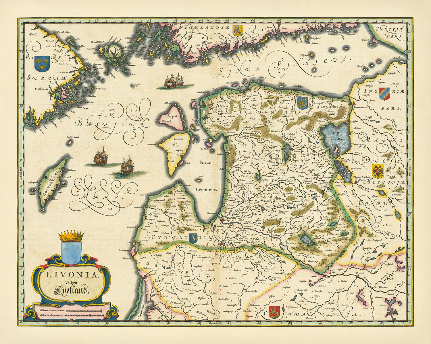
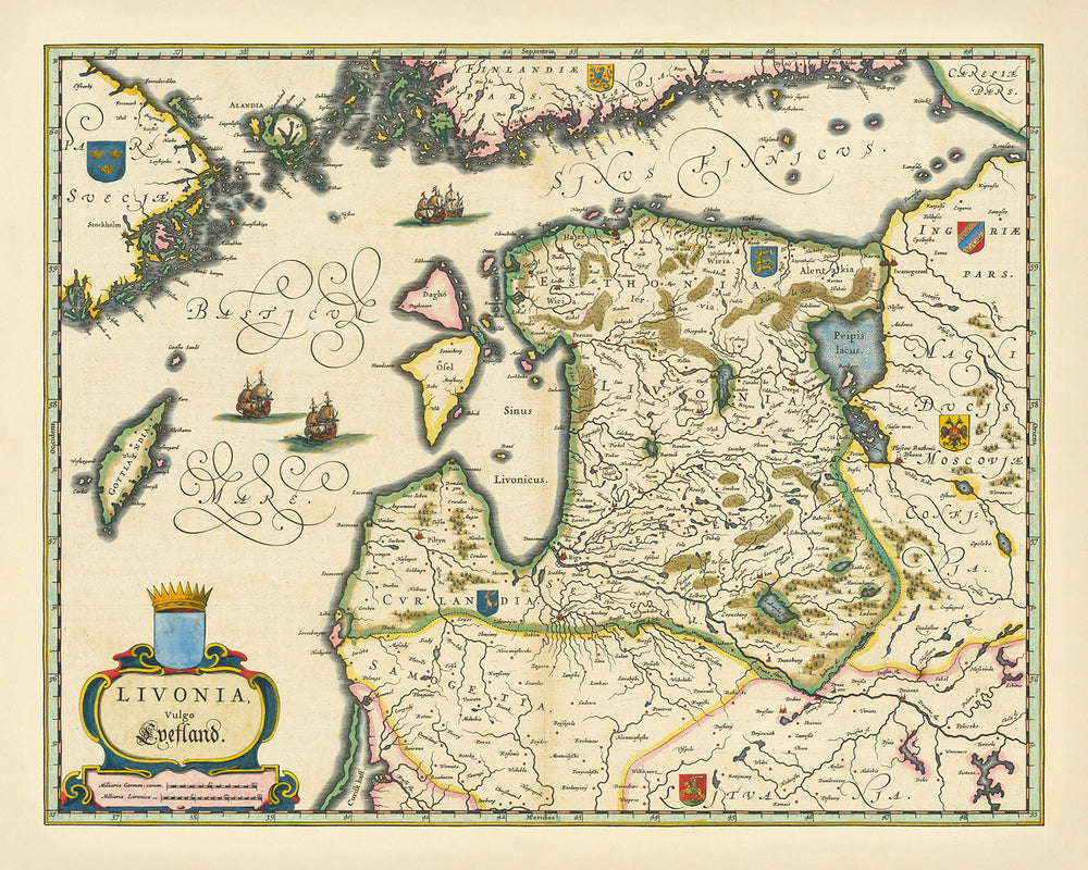
Immergiti nel ricco arazzo storico della regione baltica con il "Livonia vulgo Lyefland," una mappa straordinaria creata dal rinomato cartografo olandese Willem Janszoon Blaeu nel 1644. Questo pezzo squisito di arte cartografica cattura la complessa geografia politica e fisica del Baltico, Lituania, Estonia, Lettonia, Gottalandia e parti della Svezia e della Finlandia. Blaeu, un maestro del suo mestiere durante il Secolo d'Oro olandese, ha dettagliato meticolosamente le coste, i fiumi e le isole, fornendo un vivido spaccato del paesaggio della regione a metà del XVII secolo.
Il design della mappa è una testimonianza dell'arte e dell'attenzione ai dettagli di Blaeu. Il cartiglio decorativo nell'angolo in basso a sinistra è un piacere visivo, adornato con ornamenti che attirano l'occhio e conferiscono un'aria di grandezza all'opera. I simboli araldici che rappresentano Svezia, Finlandia, Estonia, Curlandia, Lituania, Moscovia e Ingriae aggiungono un livello di contesto storico, riflettendo le affiliazioni politiche e le nobili dinastie dell'epoca. L'inclusione di navi e mostri marini nel Mar Baltico e nel Sinus Finnicus non solo migliora l'appeal estetico della mappa, ma sottolinea anche l'importanza del commercio marittimo e della navigazione nella regione.
La mappa di Blaeu è più di una semplice rappresentazione geografica; è una finestra sul passato, offrendo intuizioni sull'importanza storica delle regioni rappresentate. La mappa mostra città e paesi chiave come Stoccolma, Helsinki, Tallinn, Riga e Vilnius, ciascuno contrassegnato con precisione e cura. Fiumi principali come il Daugava e corpi idrici notevoli come il Sinus Livonicus (Golfo di Riga) e il Sinus Finnicus (Golfo di Finlandia) sono evidenziati, mettendo in risalto le caratteristiche naturali che hanno plasmato la storia e lo sviluppo della regione.
La geografia fisica della regione baltica prende vita attraverso la cartografia esperta di Blaeu. Le aree forestali sono rappresentate con delicati simboli di alberi, mentre le catene montuose e i terreni collinari sono illustrati con sfumature sottili e linee di contorno. Le isole costiere e gli arcipelaghi, comprese le Isole Åland e Gotland, sono dettagliati meticolosamente, enfatizzando la loro importanza strategica e bellezza naturale. Questa mappa non solo funge da strumento di navigazione, ma celebra anche i paesaggi diversi e pittoreschi della regione.
Storicamente, la mappa "Livonia vulgo Lyefland" è un artefatto prezioso che cattura le dinamiche geopolitiche del XVII secolo. Riflette i confini intricati e le linee politiche dell'epoca, contrassegnate da linee colorate che delineano i territori di vari stati e regioni. Gli stemmi e i simboli araldici offrono uno sguardo sulle famiglie nobili e le entità politiche che esercitavano il potere nella regione baltica. Questa mappa non è solo un'opera d'arte; è un documento storico che offre una profonda comprensione del passato, rendendola un'aggiunta preziosa a qualsiasi collezione di mappe antiche.
Città e paesi su questa mappa
- Svezia:
- Stoccolma
- Finlandia:
- Helsinki
- Estonia:
- Tallinn
- Narva
- Tartu
- Lettonia:
- Riga
- Daugavpils
- Lituania:
- Vilnius
- Kaunas
- Russia:
- Pskov
- Novgorod
Caratteristiche e luoghi notevoli
- Cartiglio decorativo nell'angolo in basso a sinistra
- Stemma per Svezia, Finlandia, Estonia, Curlandia, Lituania, Moscovia e Ingria
- Navi raffigurate nel Mar Baltico e nel Sinus Finnicus
- Sinus Livonicus (Golfo di Riga)
- Sinus Finnicus (Golfo di Finlandia)
- Alandia (Isole Åland)
- Gottlandia (Gotland)
- Peipus Lacus (Lago Peipus)
- Rosone decorativo
- Fiumi principali e vie navigabili, come il fiume Daugava
- Aree boschive raffigurate con simboli di alberi
- Catene montuose distintive e aree collinari
- Isole costiere e arcipelaghi
- Confini e limiti politici segnati con linee colorate
- Abbellimenti artistici e calligrafia per i nomi dei luoghi
- Itinerari commerciali storici e percorsi marittimi
- Ingriae Pars (parte dell'Ingria)
- Moscoviae Pars (parte della Moscovia)
- Mar Baltico (Mare Balticum)
Contesto storico e di design
- Nome della mappa: Livonia vulgo Lyefland
- Quando è stata realizzata la mappa: 1644
- Cartografo o editore: Willem Janszoon Blaeu
- Contesto sul cartografo: Willem Janszoon Blaeu era un noto cartografo olandese, creatore di atlanti e editore conosciuto per le sue mappe dettagliate e decorative. È stato uno dei più importanti cartografi dell'Oro Olandese.
- Argomenti e temi mostrati sulla mappa:
- Confini politici: La mappa mostra i confini politici di varie regioni e paesi nell'area baltica durante la metà del XVII secolo.
- Geografia fisica: Rappresenta la geografia fisica della regione baltica, comprese le coste, i fiumi e le isole.
- Araldica: Presenta stemmi di varie regioni, indicanti le affiliazioni politiche e i simboli araldici dell'epoca.
- Attività marittima: Illustra navi nel Mar Baltico, indicando l'importanza del commercio marittimo e della navigazione.
- Design o stile della mappa:
- Cartiglio decorativo: La mappa include un cartiglio ornato, una caratteristica comune nelle mappe di questo periodo, spesso utilizzato per visualizzare il titolo e altre informazioni.
- Simboli araldici: L'uso degli stemmi aggiunge un elemento decorativo e informativo, riflettendo il panorama politico dell'epoca.
- Navi e mostri marini: L'inclusione di navi e mostri marini nelle aree marine aggiunge un tocco fantasioso e artistico, comune nelle mappe di quest'epoca.
- Significato storico o contesto:
- La mappa fornisce preziose informazioni sulla geografia e il panorama politico della regione baltica nella metà del XVII secolo.
- Riflette la conoscenza cartografica e lo stile artistico dell'Oro Olandese, un periodo di grande avanzamento nella creazione di mappe e nell'esplorazione.
Si prega di controllare attentamente le immagini per assicurarsi che una specifica città o luogo sia mostrato su questa mappa. Puoi anche contattarci e chiedere di controllare la mappa per te.
Questa mappa appare fantastica in ogni dimensione, ma consiglio sempre di optare per una dimensione più grande se hai spazio. In questo modo puoi facilmente distinguere tutti i dettagli.
Questa mappa sembra incredibile in dimensioni fino a 90in (230cm). Se stai cercando una mappa più grande, per favore contattaci.
Il modello nelle immagini dell'elenco tiene in mano la versione 16x20in (40x50cm) di questa mappa.
La quinta immagine dell'elenco mostra un esempio del mio servizio di personalizzazione delle mappe.
Se stai cercando qualcosa di leggermente diverso, dai un'occhiata alla mia collezione delle migliori vecchie mappe per vedere se qualcosa attira la tua attenzione.
Per favore contattami per verificare se una certa posizione, un monumento o una caratteristica è mostrata su questa mappa.
Questo sarebbe un meraviglioso regalo per un compleanno, Natale, Festa del Papà, un addio al lavoro, un anniversario o una festa di inaugurazione per qualcuno delle aree coperte da questa mappa.
Questa mappa è disponibile come stampa giclée su carta opaca archiviabile senza acidi, oppure puoi acquistarla incorniciata. La cornice è una semplice cornice nera che si adatta alla maggior parte degli stili. Per favore, contattami se desideri un colore o un materiale diverso per la cornice. Le mie cornici sono dotate di un vetro acrilico (perspex/acrylite) super chiaro di grado museale, che è significativamente meno riflettente del vetro, più sicuro e arriverà sempre in perfette condizioni.
This map is also available as a float framed canvas, sometimes known as a shadow gap framed canvas or canvas floater. The map is printed on artist's cotton canvas and then stretched over a handmade box frame. We then "float" the canvas inside a wooden frame, which is available in a range of colours (black, dark brown, oak, antique gold and white). This is a wonderful way to present a map without glazing in front. See some examples of float framed canvas maps and explore the differences between my different finishes.
For something truly unique, this map is also available in "Unique 3D", our trademarked process that dramatically transforms the map so that it has a wonderful sense of depth. We combine the original map with detailed topography and elevation data, so that mountains and the terrain really "pop". For more info and examples of 3D maps, check my Unique 3D page.
For most orders, delivery time is about 3 working days. Personalised and customised products take longer, as I have to do the personalisation and send it to you for approval, which usually takes 1 or 2 days.
Please note that very large framed orders usually take longer to make and deliver.
If you need your order to arrive by a certain date, please contact me before you order so that we can find the best way of making sure you get your order in time.
I print and frame maps and artwork in 23 countries around the world. This means your order will be made locally, which cuts down on delivery time and ensures that it won't be damaged during delivery. You'll never pay customs or import duty, and we'll put less CO2 into the air.
All of my maps and art prints are well packaged and sent in a rugged tube if unframed, or surrounded by foam if framed.
I try to send out all orders within 1 or 2 days of receiving your order, though some products (like face masks, mugs and tote bags) can take longer to make.
If you select Express Delivery at checkout your order we will prioritise your order and send it out by 1-day courier (Fedex, DHL, UPS, Parcelforce).
Next Day delivery is also available in some countries (US, UK, Singapore, UAE) but please try to order early in the day so that we can get it sent out on time.
My standard frame is a gallery style black ash hardwood frame. It is simple and quite modern looking. My standard frame is around 20mm (0.8in) wide.
I use super-clear acrylic (perspex/acrylite) for the frame glass. It's lighter and safer than glass - and it looks better, as the reflectivity is lower.
Six standard frame colours are available for free (black, dark brown, dark grey, oak, white and antique gold). Custom framing and mounting/matting is available if you're looking for something else.
Most maps, art and illustrations are also available as a framed canvas. We use matte (not shiny) cotton canvas, stretch it over a sustainably sourced box wood frame, and then 'float' the piece within a wood frame. The end result is quite beautiful, and there's no glazing to get in the way.
All frames are provided "ready to hang", with either a string or brackets on the back. Very large frames will have heavy duty hanging plates and/or a mounting baton. If you have any questions, please get in touch.
See some examples of my framed maps and framed canvas maps.
Alternatively, I can also supply old maps and artwork on canvas, foam board, cotton rag and other materials.
If you want to frame your map or artwork yourself, please read my size guide first.
Alcune delle mie vecchie mappe sono ora disponibili come tele incorniciate. Per favore contattami se desideri ordinare una dimensione che non è disponibile nel mio negozio.
Le vecchie mappe su tela sono un'alternativa interessante alle mappe incorniciate in modo convenzionale. A seconda del tuo gusto personale e dell'arredamento della stanza, le mappe su tela possono "risaltare" un po' di più rispetto a una mappa incorniciata.
My maps are extremely high quality reproductions of original maps.
I source original, rare maps from libraries, auction houses and private collections around the world, restore them at my London workshop, and then use specialist giclée inks and printers to create beautiful maps that look even better than the original.
My maps are printed on acid-free archival matte (not glossy) paper that feels very high quality and almost like card. In technical terms the paper weight/thickness is 10mil/200gsm. It's perfect for framing.
I print with Epson ultrachrome giclée UV fade resistant pigment inks - some of the best inks you can find.
I can also make maps on canvas, cotton rag and other exotic materials.
Learn more about The Unique Maps Co.
Map personalisation
If you're looking for the perfect anniversary or housewarming gift, I can personalise your map to make it truly unique. For example, I can add a short message, or highlight an important location, or add your family's coat of arms.
The options are almost infinite. Please see my map personalisation page for some wonderful examples of what's possible.
To order a personalised map, select "personalise your map" before adding it to your basket.
Get in touch if you're looking for more complex customisations and personalisations.
Map ageing
I have been asked hundreds of times over the years by customers if they could buy a map that looks even older.
Well, now you can, by selecting Aged before you add a map to your basket.
All the product photos you see on this page show the map in its Original form. This is what the map looks like today.
If you select Aged, I will age your map by hand, using a special and unique process developed through years of studying old maps, talking to researchers to understand the chemistry of aging paper, and of course... lots of practice!
If you're unsure, stick to the Original colour of the map. If you want something a bit darker and older looking, go for Aged.
Se non sei soddisfatto del tuo ordine per qualsiasi motivo, contattami per un rimborso senza problemi. Si prega di consultare la nostra politica di reso e rimborso per ulteriori informazioni.
Sono molto sicuro che ti piacerà la tua mappa restaurata o la stampa d'arte. Lo faccio dal 1984. Sono un venditore Etsy a 5 stelle. Ho venduto decine di migliaia di mappe e stampe d'arte e ho oltre 5.000 recensioni reali a 5 stelle.
Utilizzo un processo unico per restaurare mappe e opere d'arte che richiede molto tempo e lavoro. Trovare le mappe e le illustrazioni originali può richiedere mesi. Utilizzo tecnologia all'avanguardia e incredibilmente costosa per scannerizzare e restaurarle. Di conseguenza, garantisco che le mie mappe e stampe d'arte siano superiori alle altre - ecco perché posso offrire un rimborso senza problemi.
Quasi tutte le mie mappe e stampe d'arte sembrano fantastiche a grandi dimensioni (200 cm, 6,5 piedi+) e posso anche incorniciarle e consegnarle a te, tramite un corriere speciale per oggetti di grandi dimensioni. Contattami per discutere delle tue esigenze specifiche.
Or try searching for something!


