

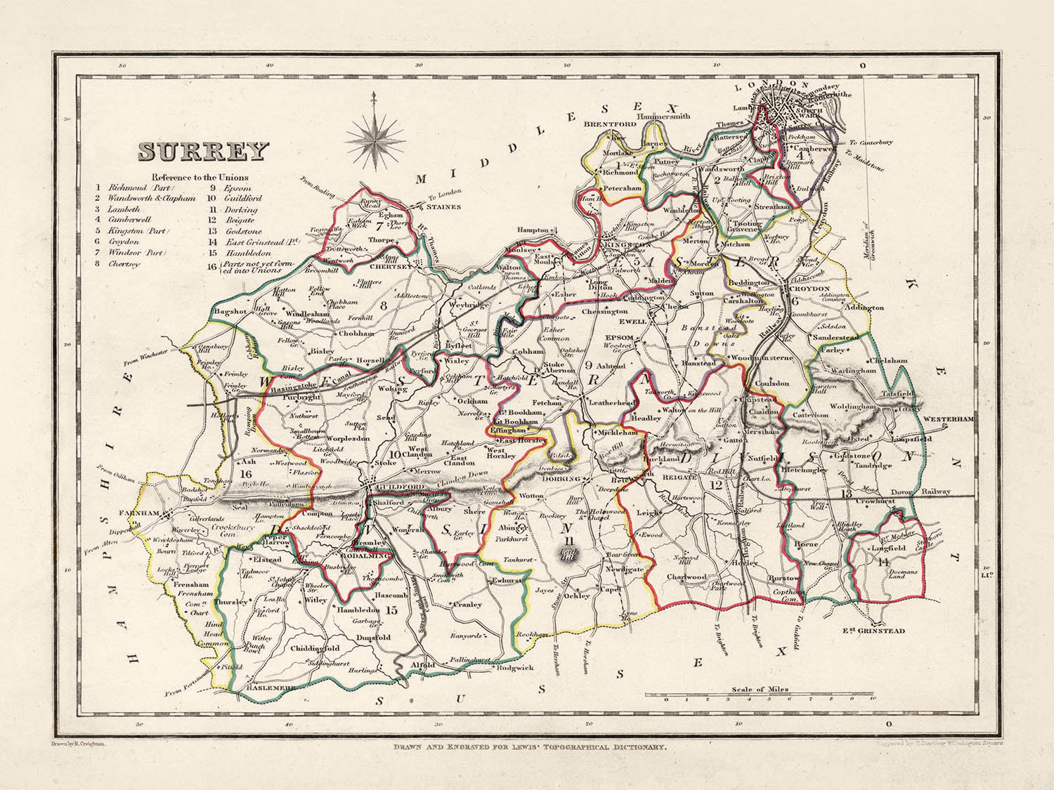
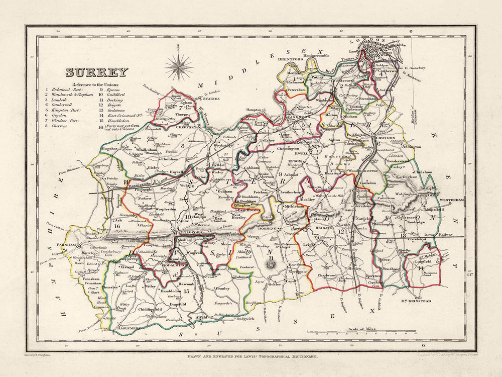


Mappa antica del Surrey di Samuel Lewis, 1844: Londra, Guildford, Woking, Ewell e Camberley
Christmas Express Delivery
You can order up until 10am on December 22 with Express Delivery to receive your order by Christmas.
Unframed products are much more likely to arrive by Christmas. Framed products may arrive on time, but they move more slowly, particularly when couriers are so overloaded with packages.
Personalised orders are unlikely to arrive on time (but if you absolutely must have a personalised product, please contact me and I'll do my best to help!)
Contact me for info on last-minute deliveries.
Spend $450, Save $90 Christmas Express Delivery available
Christmas Express Delivery
You can order up until 10am on December 22 with Express Delivery to receive your order by Christmas.
Unframed products are much more likely to arrive by Christmas. Framed products may arrive on time, but they move more slowly, particularly when couriers are so overloaded with packages.
Personalised orders are unlikely to arrive on time (but if you absolutely must have a personalised product, please contact me and I'll do my best to help!)
Contact me for info on last-minute deliveries.
Spend $450, Save $90

-
![]() Handmade in Canada
Handmade in Canada
-
FREE delivery in 3-4 days ⓘ
Free delivery in 3-4 days
Your map should be delivered in 3-4 working days with free delivery, worldwide.
Please use Express Delivery at checkout for Christmas orders. Framed orders may arrive with Express Delivery, but it is not guaranteed.
New for 2025: After you order, you can send a beautiful gift preview by email, if you're worried it won't arrive on time.
We make maps by hand locally in 23 countries, including Canada
![]() . If you're buying a gift for someone in another country, we will make the map locally to them.
. If you're buying a gift for someone in another country, we will make the map locally to them.You will never pay import tax or customs duty.
Check the Christmas delivery guide for order deadlines. Delivery times are starting to slow down, and will continue to slow down towards Christmas.
Express delivery is available at checkout which can reduce the delivery time to 1-2 days.
Please note that personalised maps, and larger framed maps, can take longer to produce and deliver.
If you need your order to arrive by a certain date, contact me and we can discuss your options.
-
FREE gift preview
ⓘ
Digital gift preview
New for 2025: After you complete your order, you can send a beautiful digital preview to the gift recipient. Just provide their email address and we'll do the rest. (Their email address will not be stored or used for any other purpose.)
This is perfect for Christmas gifting, particularly if you're concerned that your order might not arrive in time for Christmas.
-
90 day money back guarantee
ⓘ
90 giorni per restituire e ricevere un rimborso
I prodotti possono essere restituiti entro 90 giorni per un rimborso completo, o cambio con un altro prodotto.
Per articoli personalizzati e su misura, potremmo offrirti un credito in negozio o una carta regalo non scadente, poiché non possiamo rivendere ordini personalizzati.
Se hai domande, contattaci. Per ulteriori informazioni, consulta la nostra politica di restituzione e cambio.

My maps are rare, museum-grade, restored old maps sourced from libraries, auction houses and private collections across the globe.
Framing & free personalisation available
1. Select your size
2. Frame & personalise your map
There is limited framing & personalisation capacity available. Order by 10am tomorrow for Christmas delivery.


Gift message & custom finish

If you want to add a gift message, or a finish (jigsaw, aluminium board, etc.) that is not available here, please request it in the "order note" when you check out.
Every order is custom made, so if you need the size adjusted slightly, or printed on an unusual material, just let us know. We've done thousands of custom orders over the years, so there's (almost) nothing we can't manage.
You can also contact us before you order, if you prefer!

- Handmade locally. No import duty or tax
- FREE Delivery by Christmas
- Love it or your money back (90 days)
- Questions? WhatsApp me any time
Own a piece of history
5,000+ 5 star reviews


Abbraccia un pezzo di cartografia storica con questa straordinaria mappa del Surrey del 1844 di Samuel Lewis. Questa opera d'arte visivamente affascinante è più di un semplice reperto storico; è un portale nel passato, che ci consente di tracciare l'evoluzione di alcune delle città, dei paesi e degli insediamenti più amati dell'Inghilterra, che erano già radicati nella storia al momento della creazione di questa mappa.
Immergendo nella ricca storia, il passato del Surrey può essere affascinantemente tracciato attraverso i suoi insediamenti. Questa mappa del 1844 include luoghi che prosperavano prima del 1840, alcuni dei quali si sono trasformati significativamente o hanno persino cambiato nome. Al contrario, potresti trovare un'assenza di alcuni insediamenti moderni che dovevano ancora essere fondati o riconosciuti. Questo crea un'opportunità entusiasmante per la scoperta storica e il confronto.
Insediamenti
(in ordine di dimensione della popolazione moderna):- Londra (43 d.C.): Fondata dai Romani come Londinium, era una importante città commerciale e la capitale provinciale.
- Guildford (c. 970 d.C.): Sede di una Zecca Reale dal regno del re Alfredo fino all'epoca di Guglielmo il Conquistatore.
- Woking (c. 1086 d.C.): Noto nel Domesday Book come Wochinges, era posseduto dal re Guglielmo.
- Ewell (prima del 775 d.C.): Conosciuto per i suoi resti romani, inclusi una villa e una casa da bagno.
- Camberley (c. 1200 d.C.): Storicamente parte di un'area conosciuta come Bagshot Heath, famosa per i banditi nel 17° secolo.
- Redhill (c. 1818 d.C.): Originariamente una tappa sulla strada da Londra a Brighton durante il 18° secolo.
- Reigate (c. 1088 d.C.): Sede del Castello di Reigate, ritenuto essere stato fondato poco dopo la Conquista Normanna.
- Staines-upon-Thames (c. 100 d.C.): Una storica città di mercato che un tempo era il sito di un ponte romano.
- Sunbury-on-Thames (prima del 962 d.C.): Menzionata nella Cronaca Anglo-Sassone, conosciuta per la sua posizione lungo il fiume.
- Banstead (prima del 1086 d.C.): Conosciuta per la sua storia nell'agricoltura, menzionata nel Domesday Book.
- Epsom (prima del 1086 d.C.): La casa del Sale di Epsom e dell'Epsom Derby.
- Farnham (c. 688 d.C.): Nota per il suo paesaggio urbano georgiano e un antico parco per cervi.
- Dorking (c. 1086 d.C.): Sede delle Dorking Halls, una importante sede per concerti e film.
- Chertsey (c. 666 d.C.): Conosciuta per la sua Abbazia, che era uno dei più grandi monasteri benedettini in Inghilterra.
- Godalming (c. 880 d.C.): Nel 1881, divenne la prima città al mondo ad avere un fornitura pubblica di elettricità.
- Haslemere (prima del 1221 d.C.): Conosciuta per il suo centro città "georgiano e precedente".
- Caterham (prima del 1086 d.C.): Menzionata nel Domesday Book e sede del produttore di auto Caterham Cars.
- Leatherhead (prima del 880 d.C.): Un importante incrocio sulla principale rotta da Londra alla costa meridionale.
- Esher (prima del 1086 d.C.): Sede del Claremont Landscape Garden, una nota proprietà del National Trust.
- Cobham (prima del 1086 d.C.): Conosciuta per i suoi edifici storici tra cui Cobham Mill, un mulino ad acqua del 1822.
- Walton-on-Thames (prima del 1086 d.C.): Sito di un forte romano, lo "Statio Albani," sulla strada militare per Londra.
- East Molesey (prima del 1086 d.C.): Sede del Palazzo di Hampton Court, costruito per il Cardinale Thomas Wolsey all'inizio del 16° secolo.
- Ashtead (prima del 1086 d.C.): Conosciuta per la sua villa romana e le fabbriche di tegole scavate negli anni '20 e '80.
- Horley (prima del 1086 d.C.): Situato vicino all'aeroporto di Gatwick, uno dei principali aeroporti internazionali vicino a Londra.
- Oxted (c. 1086 d.C.): Casa di una casa in legno del XVI secolo conosciuta come Titsey Place.
- Frimley (prima del 1086 d.C.): Conosciuto per l'ospedale di Frimley Park, che funge da importante struttura sanitaria regionale.
- Hersham (prima del 1086 d.C.): Casa del Burhill Golf Club, situato su una parte della vecchia tenuta del Manor.
- Addlestone (c. 1241 d.C.): Conosciuto per il Crouch Oak, un albero antico che si crede risalga all'undicesimo secolo.
- Shepperton (prima del 1086 d.C.): Conosciuto per gli Shepperton Studios, uno dei principali studi cinematografici nel Regno Unito.
- Warlingham (prima del 1086 d.C.): Conosciuto per le sue terre di cintura verde nelle Surrey Hills.
Caratteristiche Notabili:
- Il fiume Tamigi, una importante via navigabile in Inghilterra, noto per il suo ruolo nel commercio, nei trasporti e nel tempo libero.
- I North Downs, una cresta di colline di gesso, parte di un'Area di Eccezionale Bellezza Naturale (AONB).
- Box Hill, una popolare attrazione turistica con panorami mozzafiato e fauna selvatica rara.
- Il lago Virginia Water, situato nel Windsor Great Park, popolare per i suoi bellissimi paesaggi.
Eventi Storici (1800-1850):
- La costruzione della ferrovia Londra-Southampton (1838), che ha portato alla rapida crescita di città come Woking.
- La corsa inaugurale dell'Epsom Derby, una prestigiosa corsa di cavalli, nel 1780 (con la sua corsa continua ben oltre il periodo studiato).
Scopri, esplora e innamorati della storia incantevole del Surrey attraverso questa straordinaria mappa del 1844 di Samuel Lewis. Un perfetto mix di storia, arte e cultura, è davvero un'ottima aggiunta a qualsiasi collezione o un grande regalo per l'appassionato di storia.
Controlla le immagini per assicurarti che una specifica città o luogo sia mostrato su questa mappa. Puoi anche contattarci e chiedere di controllare la mappa per te.
Questa mappa appare fantastica in tutte le dimensioni: 8x10in (20.5x25.5cm), 12x16in (30.5x41cm), 18x24in (45.5x61cm), 16x20in (40.5x51cm), 24x36in (61x91.5cm), 30x40in (76x101.5cm) e 37x50in (94x127cm), ma appare ancora meglio se stampata in grande.
Posso creare stampe belle e grandi di questa mappa fino a 50in (127cm). Contattami se stai cercando opzioni di incorniciatura più grandi, personalizzate o diverse.
Il modello nelle immagini dell'annuncio tiene la versione 18x24in (45.5x61cm) di questa mappa.
La quinta immagine dell'annuncio mostra un esempio del mio servizio di personalizzazione della mappa.
Se stai cercando qualcosa di leggermente diverso, dai un'occhiata alla mia principale collezione di mappe del Regno Unito e dell'Irlanda.
Per favore contattami per controllare se una certa posizione, un punto di riferimento o una caratteristica è mostrata su questa mappa.
Questo sarebbe un meraviglioso regalo di compleanno, Natale, Festa del Papà, partenza dal lavoro, anniversario o per una festa di inaugurazione per qualcuno delle aree coperte da questa mappa.
Questa mappa è disponibile come stampa giclée su carta opaca archivistica senza acidi, oppure puoi acquistarla incorniciata. La cornice è una semplice cornice nera che si adatta alla maggior parte degli stili. Contattami se desideri un colore o materiale della cornice diverso. Le mie cornici sono dotate di un acrilico (perspex/acrylite) di grado museale super chiaro, che è significativamente meno riflettente del vetro, più sicuro e arriverà sempre in perfette condizioni.
This map is also available as a float framed canvas, sometimes known as a shadow gap framed canvas or canvas floater. The map is printed on artist's cotton canvas and then stretched over a handmade box frame. We then "float" the canvas inside a wooden frame, which is available in a range of colours (black, dark brown, oak, antique gold and white). This is a wonderful way to present a map without glazing in front. See some examples of float framed canvas maps and explore the differences between my different finishes.
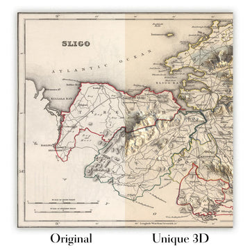
For something truly unique, this map is also available in "Unique 3D", our trademarked process that dramatically transforms the map so that it has a wonderful sense of depth. We combine the original map with detailed topography and elevation data, so that mountains and the terrain really "pop". For more info and examples of 3D maps, check my Unique 3D page.
For most orders, delivery time is about 3 working days. Personalised and customised products take longer, as I have to do the personalisation and send it to you for approval, which usually takes 1 or 2 days.
Please note that very large framed orders usually take longer to make and deliver.
If you need your order to arrive by a certain date, please contact me before you order so that we can find the best way of making sure you get your order in time.
I print and frame maps and artwork in 23 countries around the world. This means your order will be made locally, which cuts down on delivery time and ensures that it won't be damaged during delivery. You'll never pay customs or import duty, and we'll put less CO2 into the air.
All of my maps and art prints are well packaged and sent in a rugged tube if unframed, or surrounded by foam if framed.
I try to send out all orders within 1 or 2 days of receiving your order, though some products (like face masks, mugs and tote bags) can take longer to make.
If you select Express Delivery at checkout your order we will prioritise your order and send it out by 1-day courier (Fedex, DHL, UPS, Parcelforce).
Next Day delivery is also available in some countries (US, UK, Singapore, UAE) but please try to order early in the day so that we can get it sent out on time.
My standard frame is a gallery style black ash hardwood frame. It is simple and quite modern looking. My standard frame is around 20mm (0.8in) wide.
I use super-clear acrylic (perspex/acrylite) for the frame glass. It's lighter and safer than glass - and it looks better, as the reflectivity is lower.
Six standard frame colours are available for free (black, dark brown, dark grey, oak, white and antique gold). Custom framing and mounting/matting is available if you're looking for something else.
Most maps, art and illustrations are also available as a framed canvas. We use matte (not shiny) cotton canvas, stretch it over a sustainably sourced box wood frame, and then 'float' the piece within a wood frame. The end result is quite beautiful, and there's no glazing to get in the way.
All frames are provided "ready to hang", with either a string or brackets on the back. Very large frames will have heavy duty hanging plates and/or a mounting baton. If you have any questions, please get in touch.
See some examples of my framed maps and framed canvas maps.
Alternatively, I can also supply old maps and artwork on canvas, foam board, cotton rag and other materials.
If you want to frame your map or artwork yourself, please read my size guide first.
Alcune delle mie vecchie mappe sono ora disponibili come tele incorniciate. Per favore contattami se desideri ordinare una dimensione che non è disponibile nel mio negozio.
Le vecchie mappe su tela sono un'alternativa interessante alle mappe incorniciate in modo convenzionale. A seconda del tuo gusto personale e dell'arredamento della stanza, le mappe su tela possono "risaltare" un po' di più rispetto a una mappa incorniciata.
My maps are extremely high quality reproductions of original maps.
I source original, rare maps from libraries, auction houses and private collections around the world, restore them at my London workshop, and then use specialist giclée inks and printers to create beautiful maps that look even better than the original.
My maps are printed on acid-free archival matte (not glossy) paper that feels very high quality and almost like card. In technical terms the paper weight/thickness is 10mil/200gsm. It's perfect for framing.
I print with Epson ultrachrome giclée UV fade resistant pigment inks - some of the best inks you can find.
I can also make maps on canvas, cotton rag and other exotic materials.
Learn more about The Unique Maps Co.
Map personalisation
If you're looking for the perfect anniversary or housewarming gift, I can personalise your map to make it truly unique. For example, I can add a short message, or highlight an important location, or add your family's coat of arms.
The options are almost infinite. Please see my map personalisation page for some wonderful examples of what's possible.
To order a personalised map, select "personalise your map" before adding it to your basket.
Get in touch if you're looking for more complex customisations and personalisations.
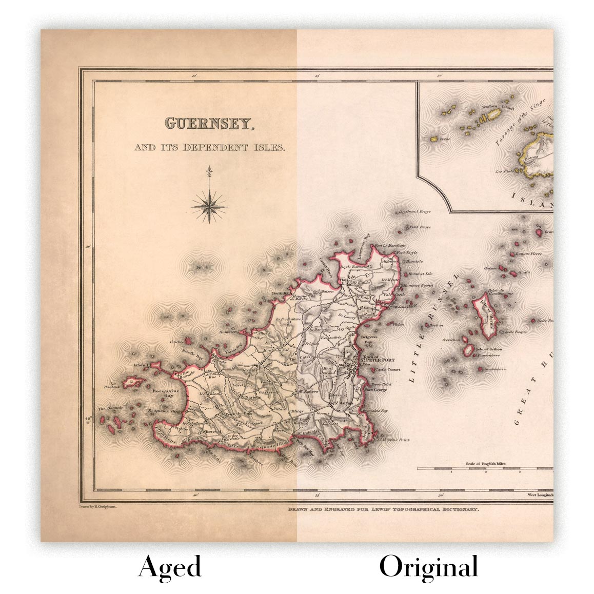
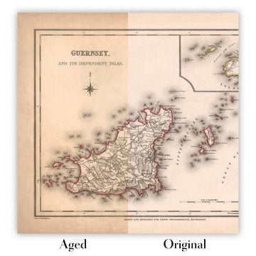
Map ageing
I have been asked hundreds of times over the years by customers if they could buy a map that looks even older.
Well, now you can, by selecting Aged before you add a map to your basket.
All the product photos you see on this page show the map in its Original form. This is what the map looks like today.
If you select Aged, I will age your map by hand, using a special and unique process developed through years of studying old maps, talking to researchers to understand the chemistry of aging paper, and of course... lots of practice!
If you're unsure, stick to the Original colour of the map. If you want something a bit darker and older looking, go for Aged.
Se non sei soddisfatto del tuo ordine per qualsiasi motivo, contattami per un rimborso senza problemi. Si prega di consultare la nostra politica di reso e rimborso per ulteriori informazioni.
Sono molto sicuro che ti piacerà la tua mappa restaurata o la stampa d'arte. Lo faccio dal 1984. Sono un venditore Etsy a 5 stelle. Ho venduto decine di migliaia di mappe e stampe d'arte e ho oltre 5.000 recensioni reali a 5 stelle.
Utilizzo un processo unico per restaurare mappe e opere d'arte che richiede molto tempo e lavoro. Trovare le mappe e le illustrazioni originali può richiedere mesi. Utilizzo tecnologia all'avanguardia e incredibilmente costosa per scannerizzare e restaurarle. Di conseguenza, garantisco che le mie mappe e stampe d'arte siano superiori alle altre - ecco perché posso offrire un rimborso senza problemi.
Quasi tutte le mie mappe e stampe d'arte sembrano fantastiche a grandi dimensioni (200 cm, 6,5 piedi+) e posso anche incorniciarle e consegnarle a te, tramite un corriere speciale per oggetti di grandi dimensioni. Contattami per discutere delle tue esigenze specifiche.
Or try searching for something!


