


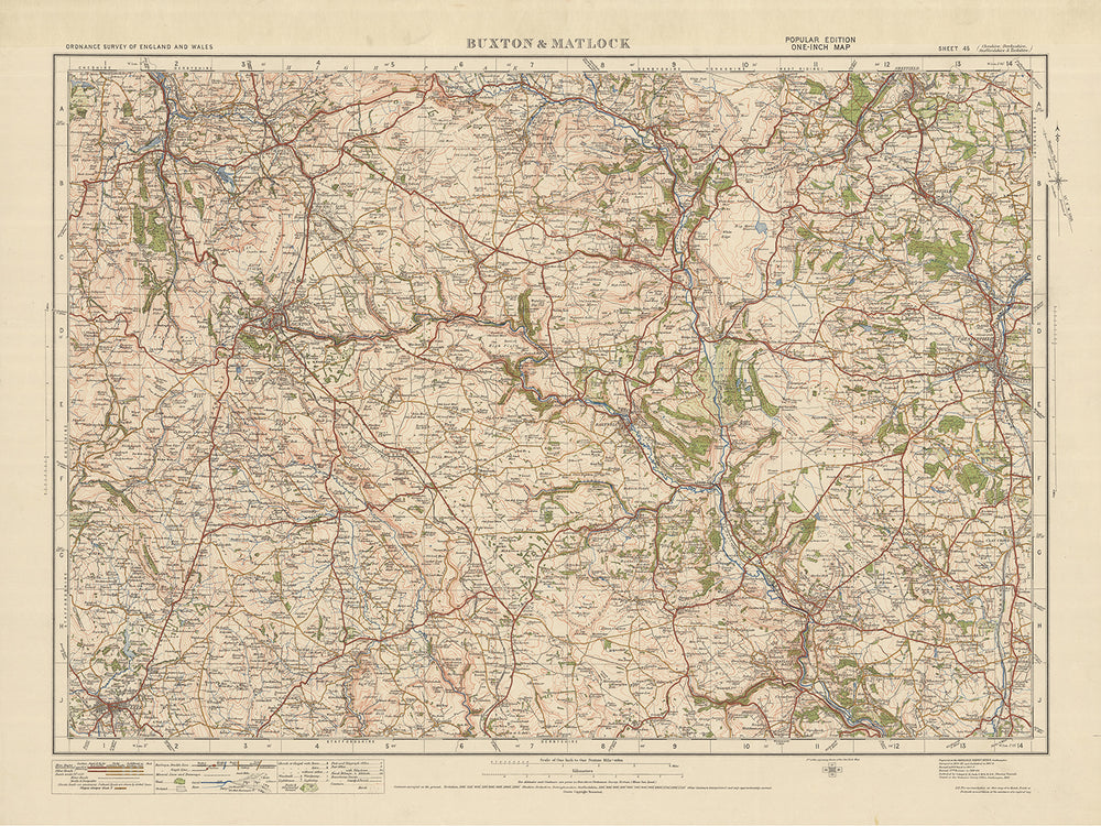


Mappa dell'Ordnance Survey, Foglio 45: Buxton e Matlock, 1925: Leek, Chesterfield, Bakewell, Chapel-en-le-Frith e Parco Nazionale del Peak District

-
![]() Handmade in Canada
Handmade in Canada
-
Christmas delivery: check the deadline
Free delivery in 3-4 days
Your map should be delivered in 3-4 working days with free delivery, worldwide.
Free delivery may arrive on time, but Express Delivery at checkout is safer. Unframed orders have a better chance of arriving in time with free delivery.
New for 2025: After you order, you can send a beautiful gift preview by email, if you're worried it won't arrive on time.
We make maps by hand locally in 23 countries, including Canada
![]() . If you're buying a gift for someone in another country, we will make the map locally to them.
. If you're buying a gift for someone in another country, we will make the map locally to them.You will never pay import tax or customs duty.
Check the Christmas delivery guide for order deadlines. Delivery times are starting to slow down, and will continue to slow down towards Christmas.
Express delivery is available at checkout which can reduce the delivery time to 1-2 days.
Please note that personalised maps, and larger framed maps, can take longer to produce and deliver.
If you need your order to arrive by a certain date, contact me and we can discuss your options.
-
90 day money back guarantee
ⓘ
90 giorni per restituire e ricevere un rimborso
I prodotti possono essere restituiti entro 90 giorni per un rimborso completo, o cambio con un altro prodotto.
Per articoli personalizzati e su misura, potremmo offrirti un credito in negozio o una carta regalo non scadente, poiché non possiamo rivendere ordini personalizzati.
Se hai domande, contattaci. Per ulteriori informazioni, consulta la nostra politica di restituzione e cambio.

My maps are rare, museum-grade, restored old maps sourced from libraries, auction houses and private collections across the globe.
Framing & free personalisation available
1. Select your size
2. Frame & personalise your map
There is limited framing & personalisation capacity available. Order by 10am tomorrow for Christmas delivery.


Gift message & custom finish

If you want to add a gift message, or a finish (jigsaw, aluminium board, etc.) that is not available here, please request it in the "order note" when you check out.
Every order is custom made, so if you need the size adjusted slightly, or printed on an unusual material, just let us know. We've done thousands of custom orders over the years, so there's (almost) nothing we can't manage.
You can also contact us before you order, if you prefer!

- Handmade locally. No import duty or tax
- FREE Delivery by Christmas
- Love it or your money back (90 days)
- Questions? WhatsApp me any time
Own a piece of history
5,000+ 5 star reviews


Questa mappa straordinaria, intitolata "Sheet 45 - Buxton & Matlock," è un pezzo autentico dell'edizione "Popolare" dell'Ordnance Survey dell'Inghilterra e del Galles, pubblicata nel 1925. Offre uno sguardo affascinante nel passato, mostrando le città di Buxton e Matlock, oltre a diversi altri insediamenti e caratteristiche notevoli. La storica contea del Derbyshire comprende sia Buxton che Matlock, rendendo questa mappa una risorsa preziosa per chiunque sia interessato alla ricca storia e geografia della regione.
Perché questa mappa è così straordinaria?
-
Una Finestra sul Passato: Questa mappa ti trasporta indietro nel tempo, permettendoti di esplorare il paesaggio di Buxton, Matlock e delle aree circostanti così come apparivano nel 1925. Fornisce un'opportunità unica di assistere allo sviluppo e ai cambiamenti che si sono verificati nel secolo scorso.
-
Gioielli Nascosti e Nomi Storici: Sebbene le città moderne possano non essere presenti su questa mappa, essa rivela città e villaggi meno conosciuti che erano significativi durante quell'epoca. Inoltre, alcune località potrebbero essere elencate con nomi precedenti, aggiungendo un'emozionante dimensione di scoperta storica alla mappa.
Principali Insediamenti e Caratteristiche:
- Buxton: Una rinomata città termale nel Derbyshire, famosa per le sue sorgenti minerali naturali e la sua splendida architettura georgiana e vittoriana.
- Matlock: Una pittoresca città situata ai margini del Peak District, nota per la sua bellezza scenica, i negozi affascinanti e il storico Matlock Bath.
- Leek: Una città di mercato nello Staffordshire, storicamente conosciuta per la sua industria tessile e la sua posizione pittoresca ai margini del Peak District.
- Chesterfield: Una storica città di mercato nel Derbyshire, nota per il suo iconico campanile storto e il suo ricco patrimonio industriale.
- Bakewell: Una deliziosa città di mercato famosa per il suo pudding di Bakewell e come porta d'accesso ai paesaggi mozzafiato del Parco Nazionale del Peak District.
- Chapel-en-le-Frith: Una piccola città immersa nel distretto dell'High Peak del Derbyshire, circondata da una bellissima campagna e da monumenti storici.
Confini, Fiumi e Caratteristiche Naturali Notevoli:
- Parco Nazionale del Peak District: Un vasto e mozzafiato parco nazionale, rinomato per i suoi paesaggi diversificati, tra cui brughiere, valli di calcare e valli pittoresche.
- Fiume Derwent: Scorrendo attraverso la regione, il Fiume Derwent si fa strada attraverso la splendida campagna del Derbyshire, offrendo bellezza scenica e opportunità ricreative.
- Kinder Scout: Parte della catena montuosa dei Pennini, Kinder Scout è un notevole altopiano di arenaria e il punto più alto del Peak District, offrendo spettacolari panorami panoramici.
Eventi Storici (entro 20 anni prima del 1925):
- 1912: Il Grande Disastro Minerario di Hucklow: Nel 1912, si verificò un tragico incidente minerario nella miniera di piombo di Great Hucklow nel Derbyshire, causando la perdita di diverse vite e lasciando un impatto duraturo sulla comunità locale.
- 1922: La Controversia del Pasticcio di Bakewell: Nel 1922, sorse una disputa legale sull'origine del famoso Pasticcio di Bakewell, una delizia regionale amata. Il caso fece luce sulla storia e le varianti di questa prelibatezza, catturando l'attenzione del pubblico.
Immergiti nella ricca storia e nella geografia affascinante di Buxton, Matlock e delle aree circostanti con questa mappa meticolosamente dettagliata del 1925. Che tu sia un appassionato di storia, un amante della cartografia o semplicemente curioso del passato, questa mappa offre un viaggio affascinante attraverso il tempo e lo spazio.
Ti preghiamo di controllare attentamente le immagini per assicurarti che una specifica città o luogo sia mostrato su questa mappa. Puoi anche contattarci e chiedere di controllare la mappa per te.
Questa mappa appare fantastica in tutte le dimensioni: 12x16in (30.5x41cm), 18x24in (45.5x61cm), 16x20in (40.5x51cm), 24x36in (61x91.5cm), 30x40in (76x101.5cm), 37x50in (94x127cm), 45x60in (114x152.5cm) e 52x70in (132x178cm), ma appare ancora meglio se stampata in grande.
Posso creare bellissime stampe grandi di questa mappa fino a 90in (229cm). Ti preghiamo di contattarci se stai cercando opzioni di incorniciatura più grandi, personalizzate o diverse.
Il modello nelle immagini dell'elenco tiene la versione 18x24in (45.5x61cm) di questa mappa.
La quinta immagine dell'elenco mostra un esempio del mio servizio di personalizzazione della mappa.
Le etichette su questa mappa sono molto piccole a 12x16in (30.5x41cm). La mappa è comunque molto attraente, ma potresti avere difficoltà a leggere le lettere più piccole. Ti preghiamo di acquistare una mappa più grande se è importante poter leggere facilmente la mappa.
Se stai cercando qualcosa di leggermente diverso, dai un'occhiata alla mia principale collezione di mappe del Regno Unito e dell'Irlanda.
Ti preghiamo di contattarmi per verificare se una certa posizione, punto di riferimento o caratteristica è mostrata su questa mappa.
Questo sarebbe un meraviglioso regalo di compleanno, Natale, Festa del Papà, partenza dal lavoro, anniversario o inaugurazione della casa per qualcuno delle aree coperte da questa mappa.
Questa mappa è disponibile come stampa giclée su carta opaca archiviata senza acidi, oppure puoi acquistarla incorniciata. La cornice è una bella e semplice cornice nera che si adatta alla maggior parte degli stili. Ti preghiamo di contattarci se desideri un colore o un materiale della cornice diverso. Le mie cornici sono vetriate con un acrilico super chiaro di qualità museale (perspex/acrylite), che è significativamente meno riflettente rispetto al vetro, più sicuro e arriverà sempre in perfette condizioni.
This map is also available as a float framed canvas, sometimes known as a shadow gap framed canvas or canvas floater. The map is printed on artist's cotton canvas and then stretched over a handmade box frame. We then "float" the canvas inside a wooden frame, which is available in a range of colours (black, dark brown, oak, antique gold and white). This is a wonderful way to present a map without glazing in front. See some examples of float framed canvas maps and explore the differences between my different finishes.
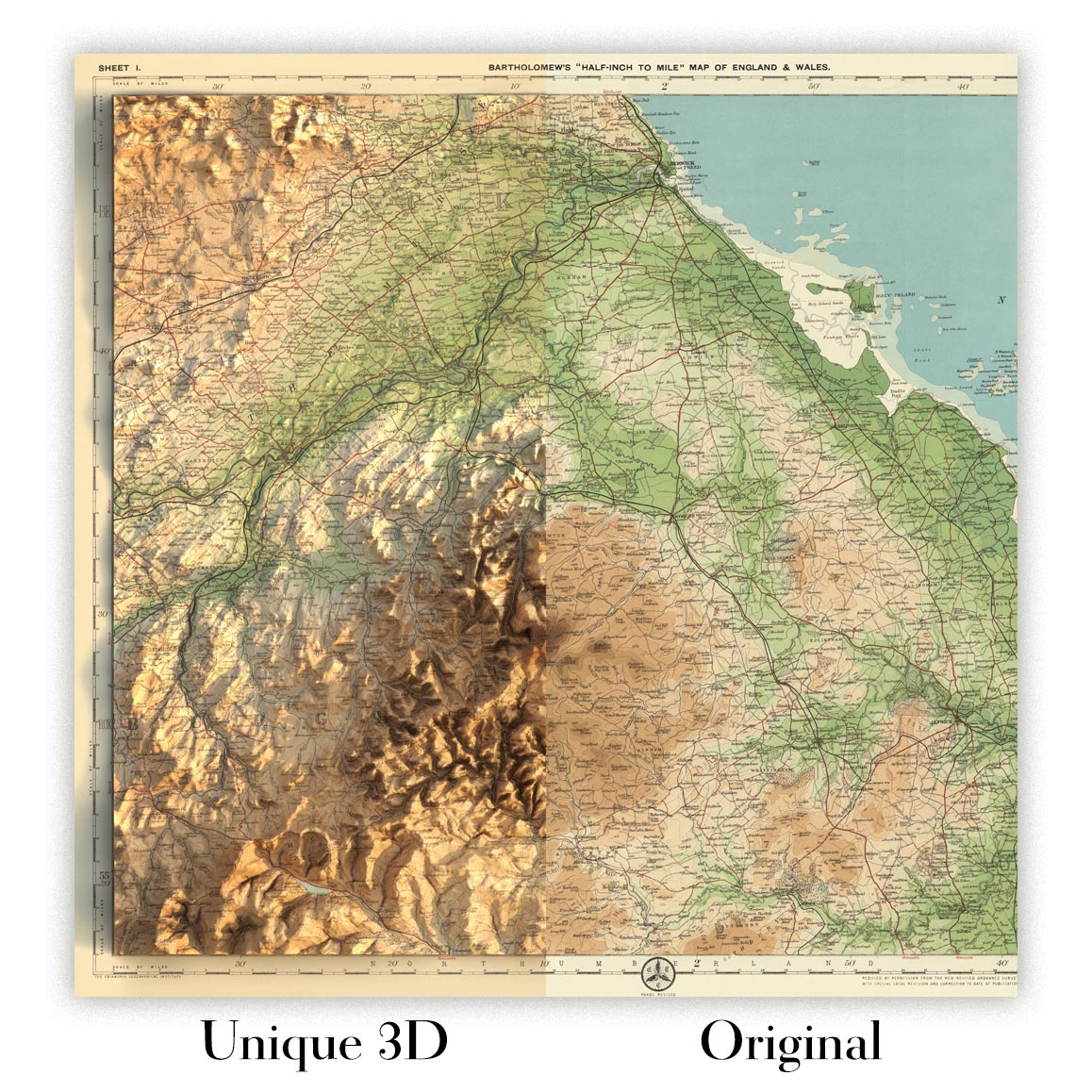
For something truly unique, this map is also available in "Unique 3D", our trademarked process that dramatically transforms the map so that it has a wonderful sense of depth. We combine the original map with detailed topography and elevation data, so that mountains and the terrain really "pop". For more info and examples of 3D maps, check my Unique 3D page.
For most orders, delivery time is about 3 working days. Personalised and customised products take longer, as I have to do the personalisation and send it to you for approval, which usually takes 1 or 2 days.
Please note that very large framed orders usually take longer to make and deliver.
If you need your order to arrive by a certain date, please contact me before you order so that we can find the best way of making sure you get your order in time.
I print and frame maps and artwork in 23 countries around the world. This means your order will be made locally, which cuts down on delivery time and ensures that it won't be damaged during delivery. You'll never pay customs or import duty, and we'll put less CO2 into the air.
All of my maps and art prints are well packaged and sent in a rugged tube if unframed, or surrounded by foam if framed.
I try to send out all orders within 1 or 2 days of receiving your order, though some products (like face masks, mugs and tote bags) can take longer to make.
If you select Express Delivery at checkout your order we will prioritise your order and send it out by 1-day courier (Fedex, DHL, UPS, Parcelforce).
Next Day delivery is also available in some countries (US, UK, Singapore, UAE) but please try to order early in the day so that we can get it sent out on time.
My standard frame is a gallery style black ash hardwood frame. It is simple and quite modern looking. My standard frame is around 20mm (0.8in) wide.
I use super-clear acrylic (perspex/acrylite) for the frame glass. It's lighter and safer than glass - and it looks better, as the reflectivity is lower.
Six standard frame colours are available for free (black, dark brown, dark grey, oak, white and antique gold). Custom framing and mounting/matting is available if you're looking for something else.
Most maps, art and illustrations are also available as a framed canvas. We use matte (not shiny) cotton canvas, stretch it over a sustainably sourced box wood frame, and then 'float' the piece within a wood frame. The end result is quite beautiful, and there's no glazing to get in the way.
All frames are provided "ready to hang", with either a string or brackets on the back. Very large frames will have heavy duty hanging plates and/or a mounting baton. If you have any questions, please get in touch.
See some examples of my framed maps and framed canvas maps.
Alternatively, I can also supply old maps and artwork on canvas, foam board, cotton rag and other materials.
If you want to frame your map or artwork yourself, please read my size guide first.
Alcune delle mie vecchie mappe sono ora disponibili come tele incorniciate. Per favore contattami se desideri ordinare una dimensione che non è disponibile nel mio negozio.
Le vecchie mappe su tela sono un'alternativa interessante alle mappe incorniciate in modo convenzionale. A seconda del tuo gusto personale e dell'arredamento della stanza, le mappe su tela possono "risaltare" un po' di più rispetto a una mappa incorniciata.
My maps are extremely high quality reproductions of original maps.
I source original, rare maps from libraries, auction houses and private collections around the world, restore them at my London workshop, and then use specialist giclée inks and printers to create beautiful maps that look even better than the original.
My maps are printed on acid-free archival matte (not glossy) paper that feels very high quality and almost like card. In technical terms the paper weight/thickness is 10mil/200gsm. It's perfect for framing.
I print with Epson ultrachrome giclée UV fade resistant pigment inks - some of the best inks you can find.
I can also make maps on canvas, cotton rag and other exotic materials.
Learn more about The Unique Maps Co.
Map personalisation
If you're looking for the perfect anniversary or housewarming gift, I can personalise your map to make it truly unique. For example, I can add a short message, or highlight an important location, or add your family's coat of arms.
The options are almost infinite. Please see my map personalisation page for some wonderful examples of what's possible.
To order a personalised map, select "personalise your map" before adding it to your basket.
Get in touch if you're looking for more complex customisations and personalisations.
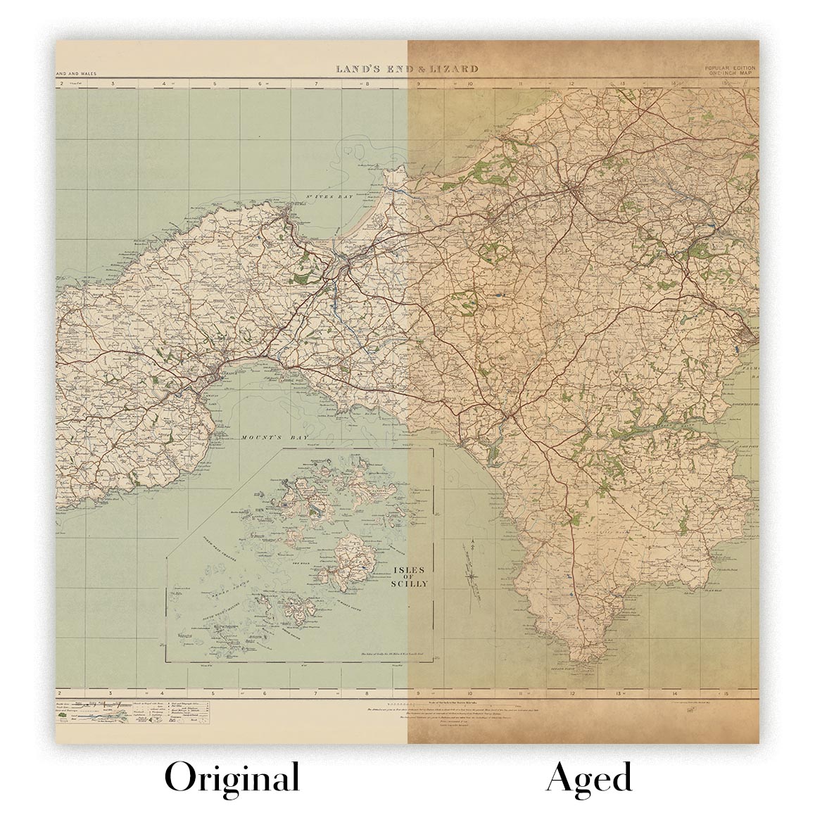
Map ageing
I have been asked hundreds of times over the years by customers if they could buy a map that looks even older.
Well, now you can, by selecting Aged before you add a map to your basket.
All the product photos you see on this page show the map in its Original form. This is what the map looks like today.
If you select Aged, I will age your map by hand, using a special and unique process developed through years of studying old maps, talking to researchers to understand the chemistry of aging paper, and of course... lots of practice!
If you're unsure, stick to the Original colour of the map. If you want something a bit darker and older looking, go for Aged.
Se non sei soddisfatto del tuo ordine per qualsiasi motivo, contattami per un rimborso senza problemi. Si prega di consultare la nostra politica di reso e rimborso per ulteriori informazioni.
Sono molto sicuro che ti piacerà la tua mappa restaurata o la stampa d'arte. Lo faccio dal 1984. Sono un venditore Etsy a 5 stelle. Ho venduto decine di migliaia di mappe e stampe d'arte e ho oltre 5.000 recensioni reali a 5 stelle.
Utilizzo un processo unico per restaurare mappe e opere d'arte che richiede molto tempo e lavoro. Trovare le mappe e le illustrazioni originali può richiedere mesi. Utilizzo tecnologia all'avanguardia e incredibilmente costosa per scannerizzare e restaurarle. Di conseguenza, garantisco che le mie mappe e stampe d'arte siano superiori alle altre - ecco perché posso offrire un rimborso senza problemi.
Quasi tutte le mie mappe e stampe d'arte sembrano fantastiche a grandi dimensioni (200 cm, 6,5 piedi+) e posso anche incorniciarle e consegnarle a te, tramite un corriere speciale per oggetti di grandi dimensioni. Contattami per discutere delle tue esigenze specifiche.
Or try searching for something!


