


Mappa Pittorica dell'Ohio di Ruth Taylor White, 1935: Columbus, Cleveland, Cincinnati, Industria, Ferrovie

-
![]() Handmade in Canada
Handmade in Canada
-
Christmas delivery: check the deadline
Free delivery in 3-4 days
Your map should be delivered in 3-4 working days with free delivery, worldwide.
Free delivery may arrive on time, but Express Delivery at checkout is safer. Unframed orders have a better chance of arriving in time with free delivery.
New for 2025: After you order, you can send a beautiful gift preview by email, if you're worried it won't arrive on time.
We make maps by hand locally in 23 countries, including Canada
![]() . If you're buying a gift for someone in another country, we will make the map locally to them.
. If you're buying a gift for someone in another country, we will make the map locally to them.You will never pay import tax or customs duty.
Check the Christmas delivery guide for order deadlines. Delivery times are starting to slow down, and will continue to slow down towards Christmas.
Express delivery is available at checkout which can reduce the delivery time to 1-2 days.
Please note that personalised maps, and larger framed maps, can take longer to produce and deliver.
If you need your order to arrive by a certain date, contact me and we can discuss your options.
-
90 day money back guarantee
ⓘ
90 giorni per restituire e ricevere un rimborso
I prodotti possono essere restituiti entro 90 giorni per un rimborso completo, o cambio con un altro prodotto.
Per articoli personalizzati e su misura, potremmo offrirti un credito in negozio o una carta regalo non scadente, poiché non possiamo rivendere ordini personalizzati.
Se hai domande, contattaci. Per ulteriori informazioni, consulta la nostra politica di restituzione e cambio.

My maps are rare, museum-grade, restored old maps sourced from libraries, auction houses and private collections across the globe.
Framing & free personalisation available
1. Select your size
2. Frame & personalise your map
There is limited framing & personalisation capacity available. Order by 10am tomorrow for Christmas delivery.


Gift message & custom finish

If you want to add a gift message, or a finish (jigsaw, aluminium board, etc.) that is not available here, please request it in the "order note" when you check out.
Every order is custom made, so if you need the size adjusted slightly, or printed on an unusual material, just let us know. We've done thousands of custom orders over the years, so there's (almost) nothing we can't manage.
You can also contact us before you order, if you prefer!

- Handmade locally. No import duty or tax
- FREE Delivery by Christmas
- Love it or your money back (90 days)
- Questions? WhatsApp me any time
Own a piece of history
5,000+ 5 star reviews


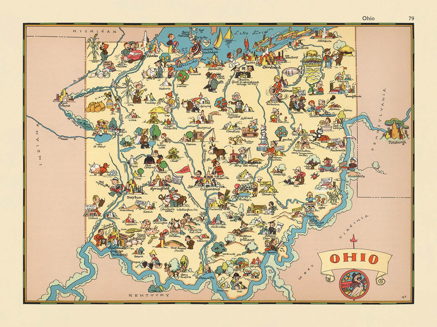
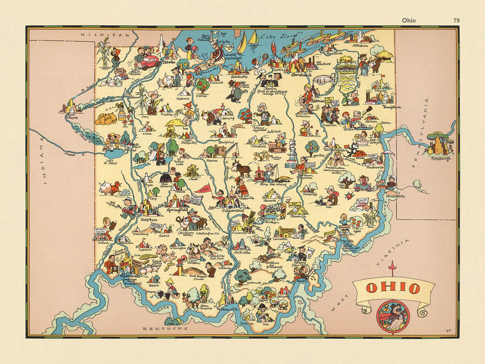
Entra nel vibrante mondo dell'America degli anni '30 con "Ohio," una mappa pittorica originale creata dalla celebre Ruth Taylor White nel 1935. Questo affascinante gioiello cartografico, originariamente parte di una serie di atlanti fantasiosi, offre un viaggio delizioso e perspicace attraverso lo Stato del Buckeye visto attraverso gli occhi di un'illustratrice esperta. Il titolo originale della mappa, semplicemente "Ohio," svela l'arte e la narrazione esuberanti che saltano da ogni angolo della sua superficie colorata.
Ruth Taylor White, rinomata per la sua distintiva fusione di illustrazione e cartografia, è stata una pioniera nel dare vita alle mappe con personalità e fascino. Il suo lavoro si distingue per la capacità di mescolare l'accuratezza geografica con un tocco narrativo, rendendo ogni mappa non solo uno strumento di navigazione, ma un portale nel cuore e nell'anima di un luogo. In "Ohio," la visione artistica di White brilla in ogni dettaglio, dalle fabbriche brulicanti e dalle terre agricole fertili ai fiumi che si snodano attraverso il paesaggio. Il suo approccio era sia educativo che divertente, progettato per catturare il pubblico di tutte le età mentre forniva un vivido istantanea della vita regionale.
Il design della mappa è una testimonianza dello stile pittorico che fiorì all'inizio del ventesimo secolo. I confini delle contee sono delineati con precisione, fornendo un senso di ordine tra le vivaci scene che popolano lo stato. Piuttosto che concentrarsi esclusivamente sulla topografia, le illustrazioni di White celebrano l'attività umana ed economica che ha definito l'Ohio negli anni '30. Scene agricole, complete di campi di coltivazioni e bestiame al pascolo, evidenziano il backbone rurale dello stato, mentre le rappresentazioni animate dell'estrazione del carbone e della produzione accennano alla potenza industriale dell'Ohio. Questi vignettes tematici trasformano la mappa in una narrazione visiva, ricca di contesto storico e colore locale.
Uno sguardo più da vicino rivela un arazzo delle città e dei paesi più significativi dell'Ohio, ciascuno reso con affetto e dettaglio. Dalla fiorente metropoli di Columbus ai centri industriali di Cleveland e Cincinnati, la mappa mette in mostra i centri urbani che hanno alimentato la crescita dello stato. Comunità più piccole, come Akron, Dayton e Toledo, sono anch'esse celebrate, i loro unici contributi all'identità dell'Ohio immortalati nell'inchiostro e nel colore. Questa attenta attenzione ai modelli di insediamento non riflette solo le realtà demografiche dell'epoca, ma offre anche uno sguardo affascinante sul paesaggio urbano in evoluzione dello stato.
Ciò che distingue davvero questa mappa è la sua capacità di catturare lo spirito dell'Ohio in un momento cruciale della sua storia. Creata durante la Grande Depressione, la mappa riflette sia la resilienza che l'ottimismo della sua gente. Le illustrazioni evocano un senso di orgoglio nelle industrie locali, nelle tradizioni e nei paesaggi, mentre sottili riferimenti ai pionieri dell'aviazione e al patrimonio dei nativi americani parlano dell'eredità culturale più ampia dello stato. Che tu sia un collezionista, un appassionato di storia o semplicemente qualcuno che apprezza l'arte delle vecchie mappe, "Ohio" di Ruth Taylor White è un capolavoro che porta il passato in vita in dettagli abbaglianti.
Città e paesi su questa mappa
- Columbus
- Cleveland
- Cincinnati
- Toledo
- Akron
- Dayton
- Parma
- Canton
- Youngstown
- Lorain
- Hamilton
- Springfield
- Elyria
- Lakewood
- Middletown
- Cascate di Cuyahoga
- Newark
- Mansfield
- Euclid
- Mentore
Caratteristiche e luoghi notevoli
- Illustrazioni di attività agricole, come l'agricoltura e l'allevamento, che riflettono il patrimonio agricolo dell'Ohio.
- Rappresentazioni della manifattura e dell'industria, che indicano il ruolo dell'Ohio come centro industriale negli anni '30.
- Rappresentazioni in stile cartone animato delle risorse naturali dell'Ohio, come l'estrazione del carbone.
- Riferimenti visivi alle reti di trasporto dello stato, comprese ferrovie e fiumi.
- Rappresentazioni artistiche delle attività ricreative, come la navigazione e la pesca, sui laghi e fiumi dell'Ohio.
- Illustrazioni delle foreste e dei paesaggi rurali dell'Ohio.
- Immagini iconiche legate all'identità culturale o storica dell'Ohio, come riferimenti all'aviazione (fratelli Wright) e al patrimonio dei nativi americani.
- Bordo decorativo con elementi tematici, che arricchisce lo stile fantasioso della mappa.
- I confini delle contee sono chiaramente segnati, ma non etichettati con nomi.
Contesto storico e di design
- Nome della mappa: "Ohio"
- Data di creazione: 1935
- Cartografo: Ruth Taylor White
- Parte di una serie più ampia: Questa mappa fa parte di un atlante pictoriale fantasioso degli Stati Uniti, che presenta ogni stato con illustrazioni uniche in stile cartone animato.
- Stile artistico: La mappa utilizza illustrazioni vivaci e colorate con uno stile giocoso e cartoonesco, caratteristico delle mappe pictoriali degli anni '30.
- Temi: La mappa evidenzia scene stereotipiche e iconiche dell'Ohio negli anni '30, riflettendo la cultura, la geografia e l'economia dello stato dell'epoca.
- Regione rappresentata: L'intero stato dell'Ohio, USA, con i confini delle contee illustrati.
- Contesto storico: La mappa fornisce un'istantanea dell'identità culturale dell'Ohio e delle immagini popolari durante la metà degli anni '30, un periodo segnato dalla Grande Depressione e da significativi cambiamenti sociali.
- Scopo: Progettata per intrattenere ed educare, mescolando informazioni geografiche con narrazione visiva.
- Valore collezionistico: La mappa è ricercata dai collezionisti per il suo merito artistico e come artefatto storico.
Si prega di controllare le immagini per assicurarsi che una specifica città o luogo sia mostrato su questa mappa. Puoi anche contattarci e chiedere di controllare la mappa per te.
Questa mappa appare fantastica in ogni dimensione, ma consiglio sempre di optare per una dimensione più grande se hai spazio. In questo modo puoi facilmente distinguere tutti i dettagli.
Questa mappa appare sorprendente in dimensioni fino a 50in (125cm). Se stai cercando una mappa più grande, per favore contattaci.
Il modello nelle immagini dell'inserzione tiene la versione della mappa 18x24in (45x60cm).
La quinta immagine dell'inserzione mostra un esempio del mio servizio di personalizzazione della mappa.
Se stai cercando qualcosa di leggermente diverso, dai un'occhiata alla mia collezione delle migliori mappe antiche per vedere se qualcosa colpisce la tua attenzione.
Si prega di contattarmi per controllare se una certa posizione, punto di riferimento o caratteristica è mostrata su questa mappa.
Questo sarebbe un meraviglioso regalo per un compleanno, Natale, Festa del Papà, un congedo dal lavoro, un anniversario o un regalo di inaugurazione per qualcuno delle aree coperte da questa mappa.
Questa mappa è disponibile come stampa giclée su carta opaca archiviata senza acidi, oppure puoi acquistarla incorniciata. La cornice è una semplice cornice nera che si adatta alla maggior parte degli stili. Ti preghiamo di contattarci se desideri un colore o un materiale di cornice diverso. Le mie cornici sono dotate di vetro acrilico super chiaro di qualità museale (perspex/acrylite), che è significativamente meno riflettente del vetro, più sicuro e arriverà sempre in perfette condizioni.
This map is also available as a float framed canvas, sometimes known as a shadow gap framed canvas or canvas floater. The map is printed on artist's cotton canvas and then stretched over a handmade box frame. We then "float" the canvas inside a wooden frame, which is available in a range of colours (black, dark brown, oak, antique gold and white). This is a wonderful way to present a map without glazing in front. See some examples of float framed canvas maps and explore the differences between my different finishes.
For something truly unique, this map is also available in "Unique 3D", our trademarked process that dramatically transforms the map so that it has a wonderful sense of depth. We combine the original map with detailed topography and elevation data, so that mountains and the terrain really "pop". For more info and examples of 3D maps, check my Unique 3D page.
For most orders, delivery time is about 3 working days. Personalised and customised products take longer, as I have to do the personalisation and send it to you for approval, which usually takes 1 or 2 days.
Please note that very large framed orders usually take longer to make and deliver.
If you need your order to arrive by a certain date, please contact me before you order so that we can find the best way of making sure you get your order in time.
I print and frame maps and artwork in 23 countries around the world. This means your order will be made locally, which cuts down on delivery time and ensures that it won't be damaged during delivery. You'll never pay customs or import duty, and we'll put less CO2 into the air.
All of my maps and art prints are well packaged and sent in a rugged tube if unframed, or surrounded by foam if framed.
I try to send out all orders within 1 or 2 days of receiving your order, though some products (like face masks, mugs and tote bags) can take longer to make.
If you select Express Delivery at checkout your order we will prioritise your order and send it out by 1-day courier (Fedex, DHL, UPS, Parcelforce).
Next Day delivery is also available in some countries (US, UK, Singapore, UAE) but please try to order early in the day so that we can get it sent out on time.
My standard frame is a gallery style black ash hardwood frame. It is simple and quite modern looking. My standard frame is around 20mm (0.8in) wide.
I use super-clear acrylic (perspex/acrylite) for the frame glass. It's lighter and safer than glass - and it looks better, as the reflectivity is lower.
Six standard frame colours are available for free (black, dark brown, dark grey, oak, white and antique gold). Custom framing and mounting/matting is available if you're looking for something else.
Most maps, art and illustrations are also available as a framed canvas. We use matte (not shiny) cotton canvas, stretch it over a sustainably sourced box wood frame, and then 'float' the piece within a wood frame. The end result is quite beautiful, and there's no glazing to get in the way.
All frames are provided "ready to hang", with either a string or brackets on the back. Very large frames will have heavy duty hanging plates and/or a mounting baton. If you have any questions, please get in touch.
See some examples of my framed maps and framed canvas maps.
Alternatively, I can also supply old maps and artwork on canvas, foam board, cotton rag and other materials.
If you want to frame your map or artwork yourself, please read my size guide first.
Alcune delle mie vecchie mappe sono ora disponibili come tele incorniciate. Per favore contattami se desideri ordinare una dimensione che non è disponibile nel mio negozio.
Le vecchie mappe su tela sono un'alternativa interessante alle mappe incorniciate in modo convenzionale. A seconda del tuo gusto personale e dell'arredamento della stanza, le mappe su tela possono "risaltare" un po' di più rispetto a una mappa incorniciata.
My maps are extremely high quality reproductions of original maps.
I source original, rare maps from libraries, auction houses and private collections around the world, restore them at my London workshop, and then use specialist giclée inks and printers to create beautiful maps that look even better than the original.
My maps are printed on acid-free archival matte (not glossy) paper that feels very high quality and almost like card. In technical terms the paper weight/thickness is 10mil/200gsm. It's perfect for framing.
I print with Epson ultrachrome giclée UV fade resistant pigment inks - some of the best inks you can find.
I can also make maps on canvas, cotton rag and other exotic materials.
Learn more about The Unique Maps Co.
Map personalisation
If you're looking for the perfect anniversary or housewarming gift, I can personalise your map to make it truly unique. For example, I can add a short message, or highlight an important location, or add your family's coat of arms.
The options are almost infinite. Please see my map personalisation page for some wonderful examples of what's possible.
To order a personalised map, select "personalise your map" before adding it to your basket.
Get in touch if you're looking for more complex customisations and personalisations.
Map ageing
I have been asked hundreds of times over the years by customers if they could buy a map that looks even older.
Well, now you can, by selecting Aged before you add a map to your basket.
All the product photos you see on this page show the map in its Original form. This is what the map looks like today.
If you select Aged, I will age your map by hand, using a special and unique process developed through years of studying old maps, talking to researchers to understand the chemistry of aging paper, and of course... lots of practice!
If you're unsure, stick to the Original colour of the map. If you want something a bit darker and older looking, go for Aged.
Se non sei soddisfatto del tuo ordine per qualsiasi motivo, contattami per un rimborso senza problemi. Si prega di consultare la nostra politica di reso e rimborso per ulteriori informazioni.
Sono molto sicuro che ti piacerà la tua mappa restaurata o la stampa d'arte. Lo faccio dal 1984. Sono un venditore Etsy a 5 stelle. Ho venduto decine di migliaia di mappe e stampe d'arte e ho oltre 5.000 recensioni reali a 5 stelle.
Utilizzo un processo unico per restaurare mappe e opere d'arte che richiede molto tempo e lavoro. Trovare le mappe e le illustrazioni originali può richiedere mesi. Utilizzo tecnologia all'avanguardia e incredibilmente costosa per scannerizzare e restaurarle. Di conseguenza, garantisco che le mie mappe e stampe d'arte siano superiori alle altre - ecco perché posso offrire un rimborso senza problemi.
Quasi tutte le mie mappe e stampe d'arte sembrano fantastiche a grandi dimensioni (200 cm, 6,5 piedi+) e posso anche incorniciarle e consegnarle a te, tramite un corriere speciale per oggetti di grandi dimensioni. Contattami per discutere delle tue esigenze specifiche.
Or try searching for something!


