


Mappa Pittorica del Delaware di Ruth Taylor White, 1935: Wilmington, Dover, Baia del Delaware, Spiagge, Primo Stato

-
![]() Handmade in Canada
Handmade in Canada
-
Christmas delivery: check the deadline
Free delivery in 3-4 days
Your map should be delivered in 3-4 working days with free delivery, worldwide.
Free delivery may arrive on time, but Express Delivery at checkout is safer. Unframed orders have a better chance of arriving in time with free delivery.
New for 2025: After you order, you can send a beautiful gift preview by email, if you're worried it won't arrive on time.
We make maps by hand locally in 23 countries, including Canada
![]() . If you're buying a gift for someone in another country, we will make the map locally to them.
. If you're buying a gift for someone in another country, we will make the map locally to them.You will never pay import tax or customs duty.
Check the Christmas delivery guide for order deadlines. Delivery times are starting to slow down, and will continue to slow down towards Christmas.
Express delivery is available at checkout which can reduce the delivery time to 1-2 days.
Please note that personalised maps, and larger framed maps, can take longer to produce and deliver.
If you need your order to arrive by a certain date, contact me and we can discuss your options.
-
90 day money back guarantee
ⓘ
90 giorni per restituire e ricevere un rimborso
I prodotti possono essere restituiti entro 90 giorni per un rimborso completo, o cambio con un altro prodotto.
Per articoli personalizzati e su misura, potremmo offrirti un credito in negozio o una carta regalo non scadente, poiché non possiamo rivendere ordini personalizzati.
Se hai domande, contattaci. Per ulteriori informazioni, consulta la nostra politica di restituzione e cambio.

My maps are rare, museum-grade, restored old maps sourced from libraries, auction houses and private collections across the globe.
Framing & free personalisation available
1. Select your size
2. Frame & personalise your map
There is limited framing & personalisation capacity available. Order by 10am tomorrow for Christmas delivery.


Gift message & custom finish

If you want to add a gift message, or a finish (jigsaw, aluminium board, etc.) that is not available here, please request it in the "order note" when you check out.
Every order is custom made, so if you need the size adjusted slightly, or printed on an unusual material, just let us know. We've done thousands of custom orders over the years, so there's (almost) nothing we can't manage.
You can also contact us before you order, if you prefer!

- Handmade locally. No import duty or tax
- FREE Delivery by Christmas
- Love it or your money back (90 days)
- Questions? WhatsApp me any time
Own a piece of history
5,000+ 5 star reviews


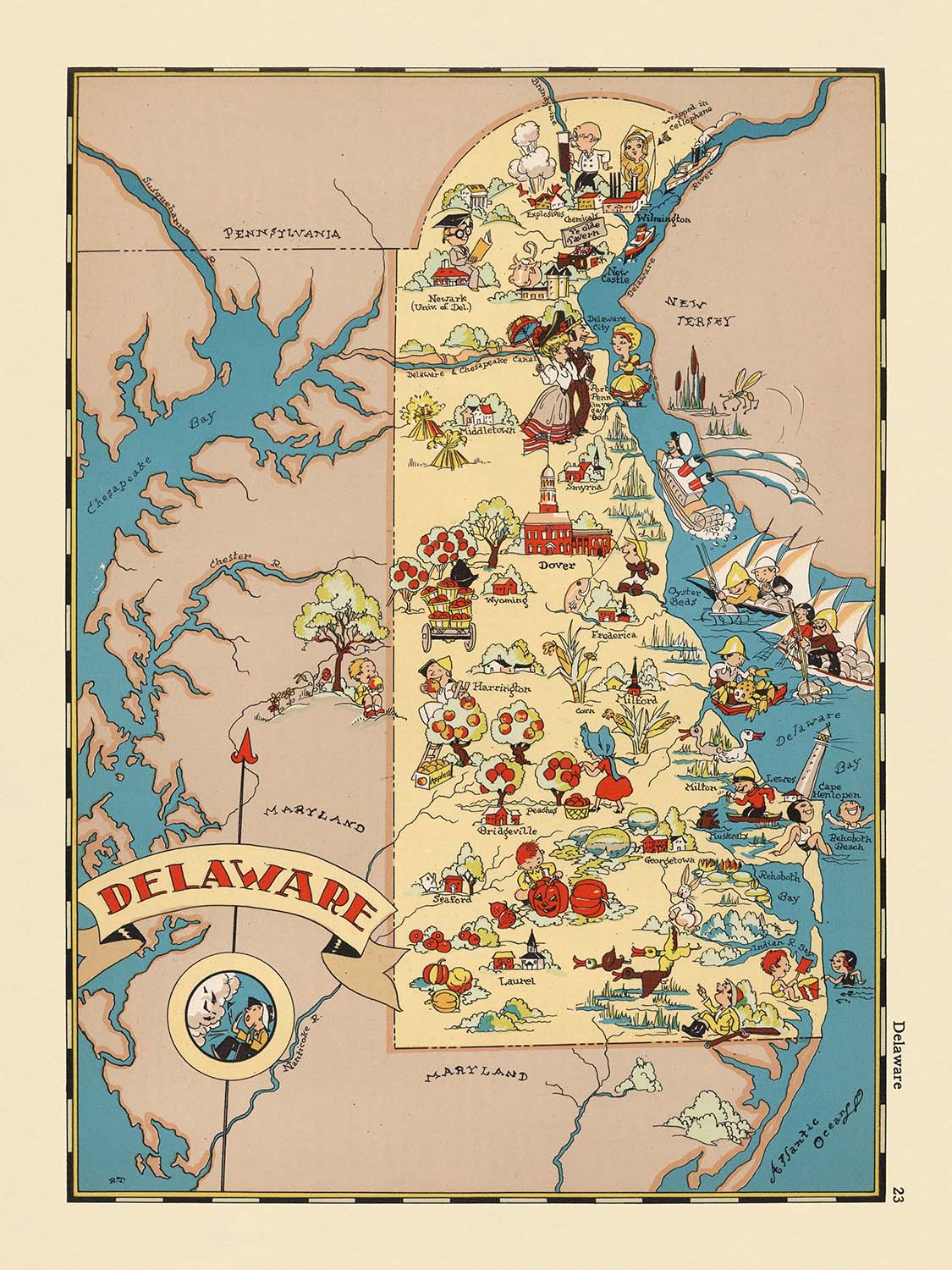
Entra nel vibrante mondo dell'Americana degli anni '30 con "Delaware", una mappa pittorica originale realizzata dalla rinomata Ruth Taylor White nel 1935. Quest'opera eccezionale è più di una rappresentazione geografica; è una celebrazione dell'identità unica del Delaware, resa in uno stile che mescola riverenza storica con arte fantasiosa. Il titolo originale della mappa, semplicemente "Delaware", suggerisce il suo focus: un'esplorazione intima e dettagliata del Primo Stato, catturando il suo spirito attraverso un arazzo colorato di illustrazioni. Come parte di una serie più ampia di mappe statali, questo pezzo si distingue per la sua capacità di racchiudere sia l'essenza che l'evoluzione del Delaware in un momento cruciale della storia americana.
Ruth Taylor White, celebrata per il suo approccio immaginativo alla cartografia, dà vita al Delaware con un'esplosione di colori vivaci e vignette giocose in stile cartone animato. La sua arte è inconfondibile, trasformando la mappa in un vivace tableau dove ogni angolo racconta una storia. Il design della mappa non è semplicemente decorativo; è profondamente informativo, utilizzando la narrazione visiva per evidenziare le caratteristiche e le industrie più amate dello stato. Il lavoro di White è una testimonianza della sua abilità nel fondere creatività artistica con accuratezza storica, rendendo le sue mappe molto ricercate da collezionisti e intenditori sia di cartografia che di cultura americana.
La ricchezza tematica della mappa è immediatamente evidente nella sua rappresentazione dei paesaggi e delle industrie diverse del Delaware. Illustrazioni ampie di attività agricole, da fertili terre agricole a scene di allevamento di pollame affollate, sottolineano l'eredità rurale e l'ossatura economica dello stato. Il fiume Delaware e la baia del Delaware sono presentati in modo prominente, le loro sinuose linee blu un promemoria delle vie d'acqua che hanno plasmato la storia e il commercio dello stato. Lungo la costa atlantica, vivaci scene di spiaggia e motivi marittimi evocano il rapporto duraturo dello stato con il mare, mentre i riferimenti all'industria cantieristica accennano al ruolo cruciale del Delaware nella prima industria americana.
Il contesto storico e culturale è tessuto senza soluzione di continuità nel tessuto della mappa. Scene che fanno riferimento all'eredità dei nativi americani e all'insediamento coloniale onorano il passato profondamente radicato della regione, mentre allusioni visive all'industria chimica DuPont evidenziano l'emergere del Delaware come centro di innovazione. Forse la cosa più sorprendente è la proclamazione orgogliosa del Delaware come "Primo Stato", un omaggio alla sua distinzione di essere il primo a ratificare la Costituzione degli Stati Uniti. I confini delle contee—New Castle, Kent e Sussex—sono elegantemente illustrati, ciascuna area adornata con motivi che riflettono il suo carattere locale e la sua importanza storica.
Completando questo ritratto affascinante ci sono le città e i paesi dello stato, ciascuno reso con un fascino che riflette la loro prominenza moderna. Wilmington, Dover, Newark e Middletown, tra gli altri, sono artisticamente rappresentati, le loro posizioni ancorando la mappa sia nel tempo che nello spazio. L'inclusione di questi insediamenti, insieme a immagini evocative della fauna locale e delle risorse naturali, crea una narrazione stratificata che invita gli spettatori a esplorare il passato e il presente del Delaware. Per collezionisti e appassionati, questa mappa non è solo un piacere visivo ma anche un artefatto significativo—un invito a viaggiare attraverso i paesaggi storici e la cultura vibrante del Delaware vista attraverso gli occhi di uno dei più distintivi cartografi d'America.
Città e paesi su questa mappa
- Wilmington
- Dover
- Newark
- Middletown
- Milford
- Seaford
- New Castle
- Smyrna
- Georgetown
- Laurel
- Harrington
- Lewes
- Delaware City
- Rehoboth Beach
- Milton
- Camden
- Bridgeville
- Selbyville
- Clayton
- Millsboro
Caratteristiche e monumenti notevoli
- Illustrazioni di attività agricole, come l'agricoltura e l'allevamento di pollame, che riflettono l'economia rurale del Delaware negli anni '30
- Rappresentazioni del fiume Delaware e della baia del Delaware, evidenziando le importanti vie navigabili dello stato
- Caratteristiche costiere e spiagge lungo l'Oceano Atlantico
- Rappresentazione dell'industria della costruzione navale, un'importante industria storica nel Delaware
- Immagini del patrimonio dei nativi americani, riconoscendo la storia indigena della regione
- Scene della storia coloniale, che fanno riferimento al ruolo del Delaware nei primi insediamenti americani
- Iconografia relativa all'industria chimica DuPont, una forza economica principale nel Delaware
- Riferimenti visivi allo status del Delaware come "Primo Stato" a ratificare la Costituzione degli Stati Uniti
- Confini e nomi delle contee (New Castle, Kent, Sussex) chiaramente illustrati
- Illustrazioni della fauna locale, come pollame e pesci, che riflettono le risorse naturali del Delaware
Contesto storico e di design
- Nome della mappa: Delaware
- Data di creazione: 1935
- Cartografo: Ruth Taylor White
- Parte di un atlante illustrato bizzarro degli Stati Uniti degli anni '30, noto per le illustrazioni colorate e coinvolgenti
- Utilizza illustrazioni vivaci e in stile cartone animato per rappresentare scene e stereotipi rappresentativi del Delaware negli anni '30
- Cattura l'essenza del Delaware negli anni '30, riflettendo sia la cultura che gli eventi storici o le industrie significative per lo stato in quel periodo
- Funziona sia come documento storico che come opera d'arte americana, apprezzata da collezionisti e da chi è interessato alla cartografia e alla storia degli Stati Uniti
Si prega di controllare attentamente le immagini per assicurarsi che una specifica città o luogo sia mostrato su questa mappa. Puoi anche contattarci e chiedere di controllare la mappa per te.
Questa mappa appare fantastica in ogni dimensione, ma consiglio sempre di optare per una dimensione più grande se hai spazio. In questo modo puoi facilmente distinguere tutti i dettagli.
Questa mappa sembra incredibile in dimensioni fino a 50in (125cm). Se stai cercando una mappa più grande, per favore contattaci.
Il modello nelle immagini dell'elenco sta tenendo la versione di questa mappa 18x24in (45x60cm).
La quinta immagine dell'elenco mostra un esempio del mio servizio di personalizzazione della mappa.
Se stai cercando qualcosa di leggermente diverso, dai un'occhiata alla mia collezione delle migliori mappe antiche per vedere se qualcosa attira la tua attenzione.
Per favore contattami per verificare se una certa posizione, monumento o caratteristica è mostrata su questa mappa.
Questa sarebbe un meraviglioso regalo di compleanno, Natale, festa del papà, partenza dal lavoro, anniversario o inaugurazione della casa per qualcuno delle aree coperte da questa mappa.
Questa mappa è disponibile come stampa giclée su carta opaca archiviabile senza acidi, oppure puoi acquistarla incorniciata. La cornice è una bella e semplice cornice nera che si adatta alla maggior parte degli stili. Per favore contattaci se desideri un colore o materiale della cornice diverso. Le mie cornici sono dotate di un acrilico super chiaro di grado museale (perspex/acrylite), che è significativamente meno riflettente del vetro, più sicuro e arriverà sempre in perfette condizioni.
This map is also available as a float framed canvas, sometimes known as a shadow gap framed canvas or canvas floater. The map is printed on artist's cotton canvas and then stretched over a handmade box frame. We then "float" the canvas inside a wooden frame, which is available in a range of colours (black, dark brown, oak, antique gold and white). This is a wonderful way to present a map without glazing in front. See some examples of float framed canvas maps and explore the differences between my different finishes.
For something truly unique, this map is also available in "Unique 3D", our trademarked process that dramatically transforms the map so that it has a wonderful sense of depth. We combine the original map with detailed topography and elevation data, so that mountains and the terrain really "pop". For more info and examples of 3D maps, check my Unique 3D page.
For most orders, delivery time is about 3 working days. Personalised and customised products take longer, as I have to do the personalisation and send it to you for approval, which usually takes 1 or 2 days.
Please note that very large framed orders usually take longer to make and deliver.
If you need your order to arrive by a certain date, please contact me before you order so that we can find the best way of making sure you get your order in time.
I print and frame maps and artwork in 23 countries around the world. This means your order will be made locally, which cuts down on delivery time and ensures that it won't be damaged during delivery. You'll never pay customs or import duty, and we'll put less CO2 into the air.
All of my maps and art prints are well packaged and sent in a rugged tube if unframed, or surrounded by foam if framed.
I try to send out all orders within 1 or 2 days of receiving your order, though some products (like face masks, mugs and tote bags) can take longer to make.
If you select Express Delivery at checkout your order we will prioritise your order and send it out by 1-day courier (Fedex, DHL, UPS, Parcelforce).
Next Day delivery is also available in some countries (US, UK, Singapore, UAE) but please try to order early in the day so that we can get it sent out on time.
My standard frame is a gallery style black ash hardwood frame. It is simple and quite modern looking. My standard frame is around 20mm (0.8in) wide.
I use super-clear acrylic (perspex/acrylite) for the frame glass. It's lighter and safer than glass - and it looks better, as the reflectivity is lower.
Six standard frame colours are available for free (black, dark brown, dark grey, oak, white and antique gold). Custom framing and mounting/matting is available if you're looking for something else.
Most maps, art and illustrations are also available as a framed canvas. We use matte (not shiny) cotton canvas, stretch it over a sustainably sourced box wood frame, and then 'float' the piece within a wood frame. The end result is quite beautiful, and there's no glazing to get in the way.
All frames are provided "ready to hang", with either a string or brackets on the back. Very large frames will have heavy duty hanging plates and/or a mounting baton. If you have any questions, please get in touch.
See some examples of my framed maps and framed canvas maps.
Alternatively, I can also supply old maps and artwork on canvas, foam board, cotton rag and other materials.
If you want to frame your map or artwork yourself, please read my size guide first.
Alcune delle mie vecchie mappe sono ora disponibili come tele incorniciate. Per favore contattami se desideri ordinare una dimensione che non è disponibile nel mio negozio.
Le vecchie mappe su tela sono un'alternativa interessante alle mappe incorniciate in modo convenzionale. A seconda del tuo gusto personale e dell'arredamento della stanza, le mappe su tela possono "risaltare" un po' di più rispetto a una mappa incorniciata.
My maps are extremely high quality reproductions of original maps.
I source original, rare maps from libraries, auction houses and private collections around the world, restore them at my London workshop, and then use specialist giclée inks and printers to create beautiful maps that look even better than the original.
My maps are printed on acid-free archival matte (not glossy) paper that feels very high quality and almost like card. In technical terms the paper weight/thickness is 10mil/200gsm. It's perfect for framing.
I print with Epson ultrachrome giclée UV fade resistant pigment inks - some of the best inks you can find.
I can also make maps on canvas, cotton rag and other exotic materials.
Learn more about The Unique Maps Co.
Map personalisation
If you're looking for the perfect anniversary or housewarming gift, I can personalise your map to make it truly unique. For example, I can add a short message, or highlight an important location, or add your family's coat of arms.
The options are almost infinite. Please see my map personalisation page for some wonderful examples of what's possible.
To order a personalised map, select "personalise your map" before adding it to your basket.
Get in touch if you're looking for more complex customisations and personalisations.
Map ageing
I have been asked hundreds of times over the years by customers if they could buy a map that looks even older.
Well, now you can, by selecting Aged before you add a map to your basket.
All the product photos you see on this page show the map in its Original form. This is what the map looks like today.
If you select Aged, I will age your map by hand, using a special and unique process developed through years of studying old maps, talking to researchers to understand the chemistry of aging paper, and of course... lots of practice!
If you're unsure, stick to the Original colour of the map. If you want something a bit darker and older looking, go for Aged.
Se non sei soddisfatto del tuo ordine per qualsiasi motivo, contattami per un rimborso senza problemi. Si prega di consultare la nostra politica di reso e rimborso per ulteriori informazioni.
Sono molto sicuro che ti piacerà la tua mappa restaurata o la stampa d'arte. Lo faccio dal 1984. Sono un venditore Etsy a 5 stelle. Ho venduto decine di migliaia di mappe e stampe d'arte e ho oltre 5.000 recensioni reali a 5 stelle.
Utilizzo un processo unico per restaurare mappe e opere d'arte che richiede molto tempo e lavoro. Trovare le mappe e le illustrazioni originali può richiedere mesi. Utilizzo tecnologia all'avanguardia e incredibilmente costosa per scannerizzare e restaurarle. Di conseguenza, garantisco che le mie mappe e stampe d'arte siano superiori alle altre - ecco perché posso offrire un rimborso senza problemi.
Quasi tutte le mie mappe e stampe d'arte sembrano fantastiche a grandi dimensioni (200 cm, 6,5 piedi+) e posso anche incorniciarle e consegnarle a te, tramite un corriere speciale per oggetti di grandi dimensioni. Contattami per discutere delle tue esigenze specifiche.
Or try searching for something!


