


Grande Mappa Antica dell'Africa, 1957: Confini Coloniali, Proiezione di Mercatore, Geografia Dettagliata

-
![]() Handmade in Canada
Handmade in Canada
-
FREE worldwide delivery in 2-3 days ⓘ
Free delivery in 2-3 days
Your map should be delivered in 2-3 working days with free delivery, worldwide.
We make maps by hand locally in 23 countries, including Canada
![]() . If you're buying a gift for someone in another country, we will make the map locally to them.
. If you're buying a gift for someone in another country, we will make the map locally to them.You will never pay import tax or customs duty.
Express delivery is available at checkout which can reduce the delivery time to 1-2 days.
Please note that personalised maps, and larger framed maps, can take longer to produce and deliver.
If you need your order to arrive by a certain date, contact me and we can discuss your options.
-
90 day money back guarantee
ⓘ
90 giorni per restituire e ottenere un rimborso
I prodotti possono essere restituiti entro 90 giorni per un rimborso completo, o scambio con un altro prodotto.
Per articoli personalizzati o su misura, potremmo offrirti un credito in negozio o una carta regalo non scadente, poiché non possiamo rivendere ordini personalizzati.
Se hai domande, contattaci. Per ulteriori informazioni, consulta la nostra politica di restituzione e scambio.

My maps are rare, museum-grade, restored old maps sourced from libraries, auction houses and private collections across the globe.
Framing & free personalisation available
1. Select your size
2. Frame & personalise your map
Make your map unique with framing, hand-drawn customisation, vintage ageing, pop art text, unique 3D styling and moreGift message & custom finish

If you want to add a gift message, or a finish (jigsaw, aluminium board, etc.) that is not available here, please request it in the "order note" when you check out.
Every order is custom made, so if you need the size adjusted slightly, or printed on an unusual material, just let us know. We've done thousands of custom orders over the years, so there's (almost) nothing we can't manage.
You can also contact us before you order, if you prefer!

- Handmade locally. No import duty or tax
- FREE Delivery. Arrives in 2-3 days
- Love it or your money back
- Questions? WhatsApp me any time
Own a piece of history
5,000+ 5 star reviews


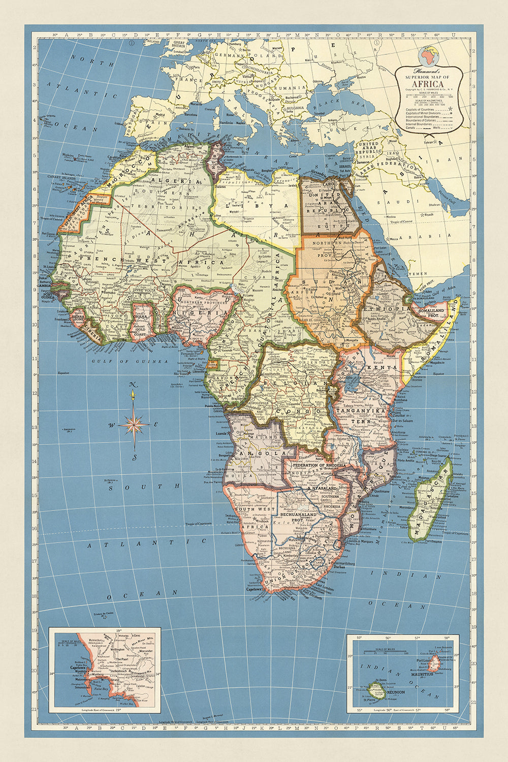
Imbarcati in un viaggio storico con "La Mappa Superiore dell'Africa di Hammond", un capolavoro cartografico che racchiude il paesaggio politico e fisico dell'Africa nell'anno cruciale del 1957. Realizzata dall'illustre C.S. Hammond & Co., un faro di eccellenza nella creazione di mappe fondato all'alba del XX secolo, questa mappa è una testimonianza dell'impegno dell'azienda per la precisione e il dettaglio. Clarence Sherman Hammond, il visionario dietro l'azienda, ha portato la sua impresa in prima linea nell'industria cartografica, assicurandosi che ogni mappa, inclusa questa splendida rappresentazione dell'Africa, fosse impregnata di un'accuratezza e di una ricchezza di informazioni senza pari. Questa mappa non serve solo come strumento di navigazione, ma anche come un vibrante documento storico, catturando l'essenza di un continente sull'orlo di un cambiamento monumentale.
Il design e lo stile della mappa sono un riflesso della sua epoca, utilizzando una proiezione di Mercatore per rappresentare la vasta estensione dell'Africa su una superficie piana. Questo grande grafico murale colorato non è solo un piacere per gli occhi ma un condotto per la comprensione, progettato per essere facilmente comprensibile. Delinea meticolosamente i complessi confini politici dell'epoca, inclusi i resti del dominio coloniale con entità come l'Africa Occidentale Francese, il Congo Belga e la Federazione di Rhodesia in evidenza. La chiarezza e l'attenzione ai dettagli della mappa la rendono una risorsa inestimabile per coloro che cercano di afferrare il complesso paesaggio geopolitico dell'Africa durante un periodo di significativa trasformazione.
Oltre al politico, "La Mappa Superiore dell'Africa di Hammond" è un tesoro di geografia fisica, che mostra i maestosi fiumi, le montagne imponenti e i vasti deserti del continente. Dalla vasta distesa del Sahara alle aspre vette delle montagne dell'Atlante e del Drakensberg, la mappa invita all'esplorazione della diversificata topografia dell'Africa. Sottolinea i principali corpi idrici, inclusi i fiumi Nilo e Congo, e i grandi laghi di Vittoria, Tanganyika e Nyasa, offrendo una panoramica completa delle caratteristiche naturali del continente. Questa rappresentazione dettagliata incoraggia una maggiore apprezzamento della diversità ambientale dell'Africa e del suo ruolo nel plasmare la storia e la cultura dei suoi popoli.
Il significato storico di questa mappa non può essere sopravvalutato. Cattura un momento nel tempo in cui l'Africa stava navigando nelle acque turbolente della decolonizzazione, con molti paesi sull'orlo di rivendicare la propria indipendenza. Questa mappa non è semplicemente una rappresentazione di terra e acqua; è un'istantanea del viaggio dell'Africa verso l'autodeterminazione, rendendola un pezzo essenziale di documentazione storica. Serve come un potente strumento educativo, fornendo intuizioni sulle sfide e i trionfi che hanno plasmato la storia del continente nel XX secolo.
In conclusione, "La Mappa Superiore dell'Africa di Hammond" è più di una semplice mappa; è un artefatto storico, un'opera d'arte e una fonte di conoscenza. Offre una finestra su un momento definitorio nella storia dell'Africa, presentata attraverso la meticolosa maestria di C.S. Hammond & Co. Che sia per lo storico, l'appassionato di cartografia o l'esploratore curioso, questa mappa è un'aggiunta lussuosa a qualsiasi collezione, invitando il suo proprietario a intraprendere un viaggio attraverso il tempo e il territorio, scoprendo le storie intrecciate nel tessuto del ricco e complesso paesaggio dell'Africa.
Paesi e regioni su questa mappa
- Africa del Nord: Marocco, Algeria, Tunisia, Libia, Egitto, Sudan, Etiopia, Somalia, Eritrea, Gibuti
- Africa Occidentale: Mauritania, Mali, Senegal, Gambia, Guinea, Sierra Leone, Liberia, Costa d'Avorio, Ghana, Togo, Benin, Nigeria, Camerun, Guinea Equatoriale, Gabon, Congo, Repubblica Centrafricana, Ciad, Niger, Burkina Faso
- Africa Meridionale: Sudafrica, Namibia, Botswana, Zimbabwe, Zambia, Malawi, Mozambico, Angola
- Africa Orientale: Kenya, Tanzania, Uganda, Rwanda, Burundi, Repubblica Democratica del Congo
- Madagascar
Caratteristiche e Monumenti Notabili
- Mappe in dettaglio: da Tangeri a Tripoli, Canale di Suez, Johannesburg e dintorni, Congo Belga e Ruanda-Urundi, Madagascar, Mauritius e Riunione
- Corpi idrici: Oceano Atlantico, Oceano Indiano, Mare Mediterraneo, Mar Rosso, Mare Arabico, Golfo Persico, Golfo di Aden, Golfo di Guinea, Canale del Mozambico, Lago Vittoria, Lago Tanganyika, Lago Nyasa
- Catene montuose: Monti Atlante, Monti Drakensberg, Altopiani Etiopici, Monti Tibesti, Monti Ahaggar
- Rotte marittime, stradali e ferroviarie: Principali rotte marittime, Principali rotte stradali, Principali rotte ferroviarie
- Altre caratteristiche: Confini politici, Città, Paesi, Villaggi, Deserti, Foreste, Praterie, Montagne, Fiumi, Laghi, Isole, Note storiche, Annotazioni
Contesto storico e di design
- Titolo: Mappa Superiore dell'Africa di Hammond
- Data: 1957
- Cartografo/Editore: C.S. Hammond & Co. era una compagnia di pubblicazione di mappe fondata nel 1900 da Clarence Sherman Hammond. Nota per la sua accuratezza e dettagli.
- Argomenti e temi: La mappa mostra la geografia politica e fisica dell'Africa, inclusi paesi, città, fiumi, montagne e deserti. Mostra anche i confini coloniali che erano in vigore all'epoca.
- Design e stile: La mappa è un grande grafico murale colorato progettato per essere facile da leggere e comprendere, utilizzando una proiezione di Mercatore.
- Significato storico: La mappa è un documento storico prezioso che fornisce un'istantanea dell'Africa nel 1957, mostrando il continente in un periodo di cambiamento significativo.
Si prega di controllare attentamente le immagini per assicurarsi che una specifica città o luogo sia mostrato su questa mappa. Puoi anche contattarci e chiedere di controllare la mappa per te.
Questa mappa appare fantastica in ogni dimensione, ma consiglio sempre di optare per una dimensione più grande se hai spazio. In questo modo puoi facilmente distinguere tutti i dettagli.
Questa mappa sembra incredibile in dimensioni fino a 100in (250cm). Se stai cercando una mappa più grande, ti preghiamo di contattarci.
Il modello nelle immagini dell'elenco sta tenendo la versione 24x36in (60x90cm) di questa mappa.
La quinta immagine dell'elenco mostra un esempio del mio servizio di personalizzazione delle mappe.
Se stai cercando qualcosa di leggermente diverso, dai un'occhiata alla mia collezione delle migliori mappe antiche per vedere se qualcosa attira la tua attenzione.
Per favore contattami per verificare se una certa posizione, monumento o caratteristica è mostrata su questa mappa.
Questo sarebbe un meraviglioso regalo per un compleanno, Natale, Festa del Papà, partenza dal lavoro, anniversario o inaugurazione della casa per qualcuno delle aree coperte da questa mappa.
Questa mappa è disponibile come stampa giclée su carta opaca archiviata senza acidi, oppure puoi acquistarla incorniciata. La cornice è una semplice cornice nera che si adatta alla maggior parte degli stili. Ti prego di contattarmi se desideri un colore o un materiale diverso per la cornice. Le mie cornici sono dotate di un vetro acrilico super chiaro di qualità museale (perspex/acrylite), che è significativamente meno riflettente del vetro, più sicuro e arriverà sempre in condizioni perfette.
This map is also available as a float framed canvas, sometimes known as a shadow gap framed canvas or canvas floater. The map is printed on artist's cotton canvas and then stretched over a handmade box frame. We then "float" the canvas inside a wooden frame, which is available in a range of colours (black, dark brown, oak, antique gold and white). This is a wonderful way to present a map without glazing in front. See some examples of float framed canvas maps and explore the differences between my different finishes.
For something truly unique, this map is also available in "Unique 3D", our trademarked process that dramatically transforms the map so that it has a wonderful sense of depth. We combine the original map with detailed topography and elevation data, so that mountains and the terrain really "pop". For more info and examples of 3D maps, check my Unique 3D page.
For most orders, delivery time is about 3 working days. Personalised and customised products take longer, as I have to do the personalisation and send it to you for approval, which usually takes 1 or 2 days.
Please note that very large framed orders usually take longer to make and deliver.
If you need your order to arrive by a certain date, please contact me before you order so that we can find the best way of making sure you get your order in time.
I print and frame maps and artwork in 23 countries around the world. This means your order will be made locally, which cuts down on delivery time and ensures that it won't be damaged during delivery. You'll never pay customs or import duty, and we'll put less CO2 into the air.
All of my maps and art prints are well packaged and sent in a rugged tube if unframed, or surrounded by foam if framed.
I try to send out all orders within 1 or 2 days of receiving your order, though some products (like face masks, mugs and tote bags) can take longer to make.
If you select Express Delivery at checkout your order we will prioritise your order and send it out by 1-day courier (Fedex, DHL, UPS, Parcelforce).
Next Day delivery is also available in some countries (US, UK, Singapore, UAE) but please try to order early in the day so that we can get it sent out on time.
My standard frame is a gallery style black ash hardwood frame. It is simple and quite modern looking. My standard frame is around 20mm (0.8in) wide.
I use super-clear acrylic (perspex/acrylite) for the frame glass. It's lighter and safer than glass - and it looks better, as the reflectivity is lower.
Six standard frame colours are available for free (black, dark brown, dark grey, oak, white and antique gold). Custom framing and mounting/matting is available if you're looking for something else.
Most maps, art and illustrations are also available as a framed canvas. We use matte (not shiny) cotton canvas, stretch it over a sustainably sourced box wood frame, and then 'float' the piece within a wood frame. The end result is quite beautiful, and there's no glazing to get in the way.
All frames are provided "ready to hang", with either a string or brackets on the back. Very large frames will have heavy duty hanging plates and/or a mounting baton. If you have any questions, please get in touch.
See some examples of my framed maps and framed canvas maps.
Alternatively, I can also supply old maps and artwork on canvas, foam board, cotton rag and other materials.
If you want to frame your map or artwork yourself, please read my size guide first.
Alcune delle mie vecchie mappe sono ora disponibili come tele incorniciate. Per favore contattami se desideri ordinare una dimensione che non è disponibile nel mio negozio.
Le vecchie mappe su tela sono un'alternativa interessante alle mappe incorniciate in modo convenzionale. A seconda del tuo gusto personale e dell'arredamento della stanza, le mappe su tela possono "risaltare" un po' di più rispetto a una mappa incorniciata.
My maps are extremely high quality reproductions of original maps.
I source original, rare maps from libraries, auction houses and private collections around the world, restore them at my London workshop, and then use specialist giclée inks and printers to create beautiful maps that look even better than the original.
My maps are printed on acid-free archival matte (not glossy) paper that feels very high quality and almost like card. In technical terms the paper weight/thickness is 10mil/200gsm. It's perfect for framing.
I print with Epson ultrachrome giclée UV fade resistant pigment inks - some of the best inks you can find.
I can also make maps on canvas, cotton rag and other exotic materials.
Learn more about The Unique Maps Co.
Map personalisation
If you're looking for the perfect anniversary or housewarming gift, I can personalise your map to make it truly unique. For example, I can add a short message, or highlight an important location, or add your family's coat of arms.
The options are almost infinite. Please see my map personalisation page for some wonderful examples of what's possible.
To order a personalised map, select "personalise your map" before adding it to your basket.
Get in touch if you're looking for more complex customisations and personalisations.
Map ageing
I have been asked hundreds of times over the years by customers if they could buy a map that looks even older.
Well, now you can, by selecting Aged before you add a map to your basket.
All the product photos you see on this page show the map in its Original form. This is what the map looks like today.
If you select Aged, I will age your map by hand, using a special and unique process developed through years of studying old maps, talking to researchers to understand the chemistry of aging paper, and of course... lots of practice!
If you're unsure, stick to the Original colour of the map. If you want something a bit darker and older looking, go for Aged.
Se non sei soddisfatto del tuo ordine per qualsiasi motivo, contattami per un rimborso senza problemi. Si prega di consultare la nostra politica di reso e rimborso per ulteriori informazioni.
Sono molto sicuro che ti piacerà la tua mappa restaurata o la stampa d'arte. Lo faccio dal 1984. Sono un venditore Etsy a 5 stelle. Ho venduto decine di migliaia di mappe e stampe d'arte e ho oltre 5.000 recensioni reali a 5 stelle.
Utilizzo un processo unico per restaurare mappe e opere d'arte che richiede molto tempo e lavoro. Trovare le mappe e le illustrazioni originali può richiedere mesi. Utilizzo tecnologia all'avanguardia e incredibilmente costosa per scannerizzare e restaurarle. Di conseguenza, garantisco che le mie mappe e stampe d'arte siano superiori alle altre - ecco perché posso offrire un rimborso senza problemi.
Quasi tutte le mie mappe e stampe d'arte sembrano fantastiche a grandi dimensioni (200 cm, 6,5 piedi+) e posso anche incorniciarle e consegnarle a te, tramite un corriere speciale per oggetti di grandi dimensioni. Contattami per discutere delle tue esigenze specifiche.
Or try searching for something!


