


Vecchia mappa Birdseye della regione di Puget Sound, 1927: Seattle, Tacoma, Penisola Olimpica, Isole San Juan, Monte Rainier
L’offerta del Collezionista
Scegli due opere idonee e ricevi il 20% di sconto su entrambe. Scegline tre e quella al prezzo più basso è in omaggio, con un risparmio massimo del 33%.
Abbina liberamente mappe standard idonee e stampe d’arte fine art. Non è richiesto alcun codice; l’offerta viene applicata automaticamente al checkout.
Sono incluse le configurazioni standard su ordinazione. Sono esclusi formati su misura, design personalizzati e lavori su commissione.
Hai bisogno di consegne a indirizzi diversi? Contattaci prima di effettuare l’ordine.L’offerta del Collezionista
Scegli due opere idonee e ricevi il 20% di sconto su entrambe. Scegline tre e quella al prezzo più basso è in omaggio, con un risparmio massimo del 33%.
Abbina liberamente mappe standard idonee e stampe d’arte fine art. Non è richiesto alcun codice; l’offerta viene applicata automaticamente al checkout.
Sono incluse le configurazioni standard su ordinazione. Sono esclusi formati su misura, design personalizzati e lavori su commissione.
Hai bisogno di consegne a indirizzi diversi? Contattaci prima di effettuare l’ordine. Progettato a Londra Prodotto in Canada
Progettato a Londra • Prodotto in Canada
Progettato a Londra Prodotto in Canada
Progettato a Londra • Prodotto in Canada

Restaurata dalla mappa originale del 1927 e stampata in qualità museale. Leggi la storia dietro questa mappa
Choose your size
Choose your finish


(Maggiori informazioni)
Gift message & custom finish

If you want to add a gift message, or a finish (jigsaw, aluminium board, etc.) that is not available here, please request it in the "order note" when you check out.
Every order is custom made, so if you need the size adjusted slightly, or printed on an unusual material, just let us know. We've done thousands of custom orders over the years, so there's (almost) nothing we can't manage.
You can also contact us before you order, if you prefer!

- Prodotto localmente. Consegna sicura
- Nessun dazio o costo nascosto
- Serve aiuto? Chiamaci o messaggio su WhatsApp
Own a piece of history
8,000+ five-star reviews


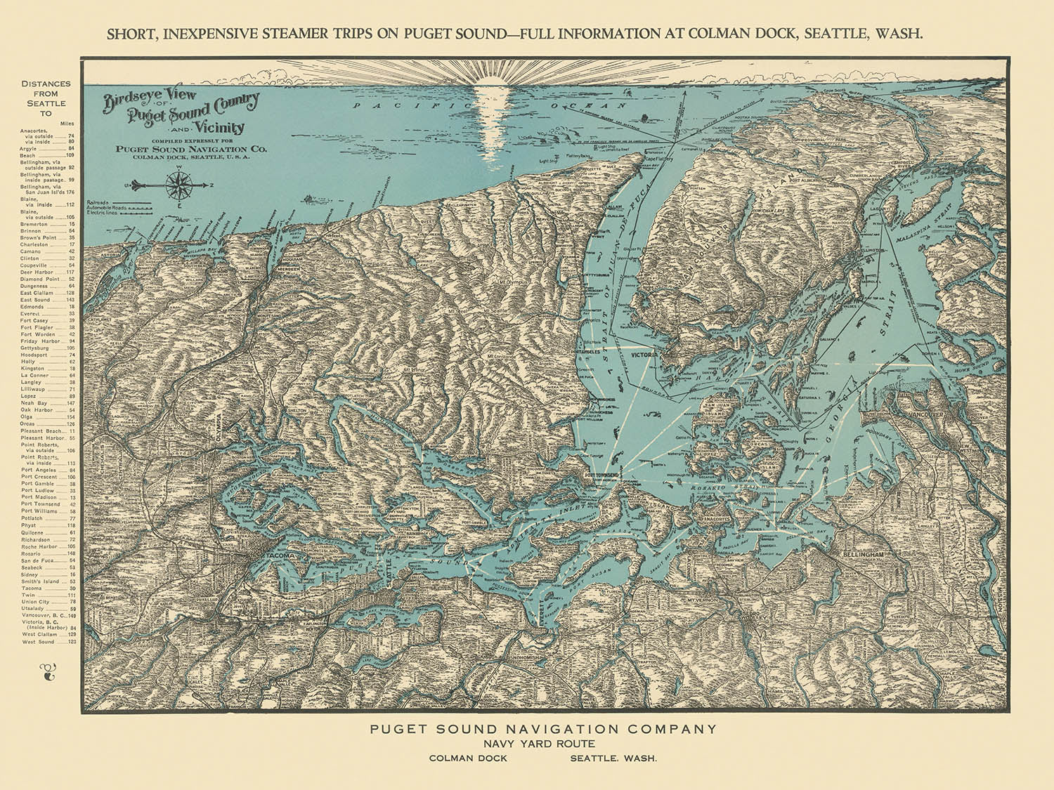
Entra nel vibrante mondo marittimo del Pacific Northwest con la “Vista a volo d'uccello del Paese di Puget Sound e dintorni,” un...
Continua a leggereEntra nel vibrante mondo marittimo del Pacific Northwest con la “Vista a volo d'uccello del Paese di Puget Sound e dintorni,” un evocativo capolavoro cartografico del 1927 commissionato dalla Puget Sound Navigation Company. Questa mappa affascinante, realizzata nel culmine dell'era delle navi a vapore della regione, invita gli spettatori a esplorare un paesaggio definito dai suoi intricati corsi d'acqua, maestose montagne e isole lussureggianti. Il titolo originale stesso suggerisce l'ambizione panoramica della mappa, offrendo una prospettiva ampia che abbraccia il Puget Sound, la Penisola Olimpica, le Isole San Juan, l'Isola di Vancouver e la regione circostante—un'area in cui natura e navigazione si intrecciano in modo spettacolare.
La Puget Sound Navigation Company, affettuosamente conosciuta come la Black Ball Line, fu fondata da Charles E. Peabody nel 1898 e presto divenne sinonimo di innovazione marittima e connettività regionale. Negli anni '30, PSNC comandava un quasi monopolio sui viaggi attraverso il suono, trasportando passeggeri e merci tra porti affollati e avamposti tranquilli. Questa mappa è stata concepita sia come strumento promozionale sia come celebrazione delle estese rotte della compagnia, mostrando l'accessibilità di “Brevi Escursioni Piacevoli” verso destinazioni come Hood Canal, la Penisola Olimpica e le Isole San Juan—ognuna un'affascinante fuga per i cittadini e gli avventurieri.
La prospettiva a volo d'uccello della mappa è una testimonianza dell'arte e della competenza tecnica dei cartografi del primo XX secolo. Realizzata con meticolosa attenzione ai dettagli, presenta un tableau riccamente testurizzato dove i corsi d'acqua brillano, le montagne svettano e le foreste si estendono sulla terra. Le catene montuose Olimpica e Cascade si ergono drammaticamente sullo sfondo, con picchi iconici come il Monte Rainier e il Monte Baker che ancorano l'orizzonte. Lo stile pittorico della mappa non solo funge da aiuto alla navigazione, ma anche da invito a meravigliarsi della grandezza naturale e della complessità geografica del Pacific Northwest.
Oltre al suo splendore visivo, la mappa è un documento di rilevanza storica, catturando un momento cruciale in cui i traghetti e le navi a vapore erano il cuore pulsante del commercio e della cultura regionale. Il confine internazionale tra gli Stati Uniti e il Canada è tracciato in modo sottile, collegando le fiorenti città di Seattle, Tacoma, Vancouver e Victoria, mentre delinea anche la bellezza selvaggia della Penisola Olimpica e l'intricato arcipelago delle Isole San Juan. Fiumi, baie e insenature principali—come lo Stretto di Juan de Fuca e lo Stretto di Georgia—sono elegantemente rappresentati, sottolineando la dipendenza della regione dal trasporto via acqua.
Ogni dettaglio di questa mappa riflette lo spirito di esplorazione e intraprendenza che ha caratterizzato l'epoca. I fari e gli aiuti alla navigazione punteggiano la costa, guidando le imbarcazioni attraverso nebbia e maree. I paesaggi boschivi e i promontori impervi evocano il carattere selvaggio della terra, mentre l'assenza di ponti e autostrade moderni suggerisce un'epoca in cui il ritmo della vita era dettato dal programma della prossima nave a vapore in partenza. Questa “Vista a volo d'uccello del Paese di Puget Sound e dintorni” è più di una mappa—è una finestra su un'epoca passata di avventura, innovazione e meraviglia naturale.
Città e paesi su questa mappa
- Seattle
- Tacoma
- Olympia
- Everett
- Bellingham
- Port Angeles
- Bremerton
- Anacortes
- Port Townsend
- Vancouver (BC)
- Victoria (BC)
Caratteristiche e punti di riferimento notevoli
- Puget Sound (principale corso d'acqua)
- Penisola Olimpica (massa terrestre prominente)
- Isole San Juan (gruppo di isole)
- Isole Vancouver (grande isola, Columbia Britannica)
- Hood Canal (braccio simile a un fiordo del Puget Sound)
- Stretto di Juan de Fuca (stretto principale tra Washington e l'isola di Vancouver)
- Stretto della Georgia (corsa d'acqua tra l'isola di Vancouver e la terraferma della BC)
- Monte Rainier (rappresentato come una montagna prominente)
- Monte Baker (rappresentato come una montagna prominente)
- Monti Olimpici (catena montuosa sulla penisola)
- Monti Cascade (catena montuosa a est)
- Rotte dei traghetti e dei battelli a vapore (illustrate sulla mappa)
- Confine internazionale tra gli Stati Uniti e il Canada (visibile sulla mappa)
- Fiumi principali (ad es., fiume Snohomish, fiume Skagit, rappresentati)
- Fari e aiuti alla navigazione (illustrati lungo le vie d'acqua)
- Golfi e insenature (ad es., Elliott Bay, Bellingham Bay)
- Capi e penisole prominenti (ad es., Cape Flattery)
Contesto storico e di design
- Creato nel 1927 dalla Puget Sound Navigation Company (PSNC), nota anche come Black Ball Line.
- La PSNC è stata fondata da Charles E. Peabody nel 1898 ed è diventata una forza dominante nei viaggi marittimi regionali.
- La mappa è stata progettata come strumento promozionale per evidenziare le rotte dei traghetti e dei battelli a vapore e incoraggiare il turismo.
- Prospettiva a volo d'uccello, altamente dettagliata e pittorica, enfatizzando le caratteristiche naturali e le vie d'acqua.
- Riflette il ruolo critico dei traghetti e delle navi a vapore nel Pacifico Nord-Occidentale prima dell'era delle autostrade e dei ponti moderni.
- Mette in evidenza l'accessibilità di “Brevi Uscite Piacevoli” verso destinazioni regionali panoramiche.
- Cattura un'epoca fondamentale di trasporto ed esplorazione nel Pacifico Nord-Occidentale.
Si prega di controllare attentamente le immagini per assicurarsi che una specifica città o luogo sia mostrato su questa mappa. Puoi anche contattarci e chiedere di controllare la mappa per te.
Questa mappa appare fantastica in ogni dimensione, ma consiglio sempre di optare per una dimensione più grande se hai spazio. In questo modo puoi facilmente distinguere tutti i dettagli.
Questa mappa appare incredibile in dimensioni fino a 90in (230cm). Se stai cercando una mappa più grande, ti preghiamo di contattarci.
Il modello nelle immagini dell'annuncio sta tenendo la versione 18x24in (45x60cm) di questa mappa.
La quinta immagine dell'annuncio mostra un esempio del mio servizio di personalizzazione della mappa.
Se stai cercando qualcosa di leggermente diverso, dai un'occhiata alla mia collezione delle migliori mappe antiche per vedere se qualcosa attira la tua attenzione.
Si prega di contattarmi per controllare se una certa posizione, punto di riferimento o caratteristica è mostrata su questa mappa.
Questo sarebbe un regalo meraviglioso per un compleanno, Natale, Festa del Papà, pensionamento, anniversario o inaugurazione per qualcuno delle aree coperte da questa mappa.
Questa mappa è disponibile come stampa giclée su carta opaca archiviata senza acidi, oppure puoi acquistarla incorniciata. La cornice è una semplice cornice nera che si adatta alla maggior parte degli stili. Si prega di contattarci se desideri un colore o materiale della cornice diverso. Le mie cornici sono dotate di un acrilico (perspex/acrylite) super chiaro di grado museale, che è significativamente meno riflettente del vetro, più sicuro e arriverà sempre in perfette condizioni.
This map is also available as a float framed canvas, sometimes known as a shadow gap framed canvas or canvas floater. The map is printed on artist's cotton canvas and then stretched over a handmade box frame. We then "float" the canvas inside a wooden frame, which is available in a range of colours (black, dark brown, oak, antique gold and white). This is a wonderful way to present a map without glazing in front. See some examples of float framed canvas maps and explore the differences between my different finishes.
For something truly unique, this map is also available in "Unique 3D", our trademarked process that dramatically transforms the map so that it has a wonderful sense of depth. We combine the original map with detailed topography and elevation data, so that mountains and the terrain really "pop". For more info and examples of 3D maps, check my Unique 3D page.
Entra nel vibrante mondo marittimo del Pacific Northwest con la “Vista a volo d'uccello del Paese di Puget Sound e dintorni,” un evocativo capolavoro cartografico del 1927 commissionato dalla Puget Sound Navigation Company. Questa mappa affascinante, realizzata nel culmine dell'era delle navi a vapore della regione, invita gli spettatori a esplorare un paesaggio definito dai suoi intricati corsi d'acqua, maestose montagne e isole lussureggianti. Il titolo originale stesso suggerisce l'ambizione panoramica della mappa, offrendo una prospettiva ampia che abbraccia il Puget Sound, la Penisola Olimpica, le Isole San Juan, l'Isola di Vancouver e la regione circostante—un'area in cui natura e navigazione si intrecciano in modo spettacolare.
La Puget Sound Navigation Company, affettuosamente conosciuta come la Black Ball Line, fu fondata da Charles E. Peabody nel 1898 e presto divenne sinonimo di innovazione marittima e connettività regionale. Negli anni '30, PSNC comandava un quasi monopolio sui viaggi attraverso il suono, trasportando passeggeri e merci tra porti affollati e avamposti tranquilli. Questa mappa è stata concepita sia come strumento promozionale sia come celebrazione delle estese rotte della compagnia, mostrando l'accessibilità di “Brevi Escursioni Piacevoli” verso destinazioni come Hood Canal, la Penisola Olimpica e le Isole San Juan—ognuna un'affascinante fuga per i cittadini e gli avventurieri.
La prospettiva a volo d'uccello della mappa è una testimonianza dell'arte e della competenza tecnica dei cartografi del primo XX secolo. Realizzata con meticolosa attenzione ai dettagli, presenta un tableau riccamente testurizzato dove i corsi d'acqua brillano, le montagne svettano e le foreste si estendono sulla terra. Le catene montuose Olimpica e Cascade si ergono drammaticamente sullo sfondo, con picchi iconici come il Monte Rainier e il Monte Baker che ancorano l'orizzonte. Lo stile pittorico della mappa non solo funge da aiuto alla navigazione, ma anche da invito a meravigliarsi della grandezza naturale e della complessità geografica del Pacific Northwest.
Oltre al suo splendore visivo, la mappa è un documento di rilevanza storica, catturando un momento cruciale in cui i traghetti e le navi a vapore erano il cuore pulsante del commercio e della cultura regionale. Il confine internazionale tra gli Stati Uniti e il Canada è tracciato in modo sottile, collegando le fiorenti città di Seattle, Tacoma, Vancouver e Victoria, mentre delinea anche la bellezza selvaggia della Penisola Olimpica e l'intricato arcipelago delle Isole San Juan. Fiumi, baie e insenature principali—come lo Stretto di Juan de Fuca e lo Stretto di Georgia—sono elegantemente rappresentati, sottolineando la dipendenza della regione dal trasporto via acqua.
Ogni dettaglio di questa mappa riflette lo spirito di esplorazione e intraprendenza che ha caratterizzato l'epoca. I fari e gli aiuti alla navigazione punteggiano la costa, guidando le imbarcazioni attraverso nebbia e maree. I paesaggi boschivi e i promontori impervi evocano il carattere selvaggio della terra, mentre l'assenza di ponti e autostrade moderni suggerisce un'epoca in cui il ritmo della vita era dettato dal programma della prossima nave a vapore in partenza. Questa “Vista a volo d'uccello del Paese di Puget Sound e dintorni” è più di una mappa—è una finestra su un'epoca passata di avventura, innovazione e meraviglia naturale.
Città e paesi su questa mappa
- Seattle
- Tacoma
- Olympia
- Everett
- Bellingham
- Port Angeles
- Bremerton
- Anacortes
- Port Townsend
- Vancouver (BC)
- Victoria (BC)
Caratteristiche e punti di riferimento notevoli
- Puget Sound (principale corso d'acqua)
- Penisola Olimpica (massa terrestre prominente)
- Isole San Juan (gruppo di isole)
- Isole Vancouver (grande isola, Columbia Britannica)
- Hood Canal (braccio simile a un fiordo del Puget Sound)
- Stretto di Juan de Fuca (stretto principale tra Washington e l'isola di Vancouver)
- Stretto della Georgia (corsa d'acqua tra l'isola di Vancouver e la terraferma della BC)
- Monte Rainier (rappresentato come una montagna prominente)
- Monte Baker (rappresentato come una montagna prominente)
- Monti Olimpici (catena montuosa sulla penisola)
- Monti Cascade (catena montuosa a est)
- Rotte dei traghetti e dei battelli a vapore (illustrate sulla mappa)
- Confine internazionale tra gli Stati Uniti e il Canada (visibile sulla mappa)
- Fiumi principali (ad es., fiume Snohomish, fiume Skagit, rappresentati)
- Fari e aiuti alla navigazione (illustrati lungo le vie d'acqua)
- Golfi e insenature (ad es., Elliott Bay, Bellingham Bay)
- Capi e penisole prominenti (ad es., Cape Flattery)
Contesto storico e di design
- Creato nel 1927 dalla Puget Sound Navigation Company (PSNC), nota anche come Black Ball Line.
- La PSNC è stata fondata da Charles E. Peabody nel 1898 ed è diventata una forza dominante nei viaggi marittimi regionali.
- La mappa è stata progettata come strumento promozionale per evidenziare le rotte dei traghetti e dei battelli a vapore e incoraggiare il turismo.
- Prospettiva a volo d'uccello, altamente dettagliata e pittorica, enfatizzando le caratteristiche naturali e le vie d'acqua.
- Riflette il ruolo critico dei traghetti e delle navi a vapore nel Pacifico Nord-Occidentale prima dell'era delle autostrade e dei ponti moderni.
- Mette in evidenza l'accessibilità di “Brevi Uscite Piacevoli” verso destinazioni regionali panoramiche.
- Cattura un'epoca fondamentale di trasporto ed esplorazione nel Pacifico Nord-Occidentale.
Si prega di controllare attentamente le immagini per assicurarsi che una specifica città o luogo sia mostrato su questa mappa. Puoi anche contattarci e chiedere di controllare la mappa per te.
Questa mappa appare fantastica in ogni dimensione, ma consiglio sempre di optare per una dimensione più grande se hai spazio. In questo modo puoi facilmente distinguere tutti i dettagli.
Questa mappa appare incredibile in dimensioni fino a 90in (230cm). Se stai cercando una mappa più grande, ti preghiamo di contattarci.
Il modello nelle immagini dell'annuncio sta tenendo la versione 18x24in (45x60cm) di questa mappa.
La quinta immagine dell'annuncio mostra un esempio del mio servizio di personalizzazione della mappa.
Se stai cercando qualcosa di leggermente diverso, dai un'occhiata alla mia collezione delle migliori mappe antiche per vedere se qualcosa attira la tua attenzione.
Si prega di contattarmi per controllare se una certa posizione, punto di riferimento o caratteristica è mostrata su questa mappa.
Questo sarebbe un regalo meraviglioso per un compleanno, Natale, Festa del Papà, pensionamento, anniversario o inaugurazione per qualcuno delle aree coperte da questa mappa.
Questa mappa è disponibile come stampa giclée su carta opaca archiviata senza acidi, oppure puoi acquistarla incorniciata. La cornice è una semplice cornice nera che si adatta alla maggior parte degli stili. Si prega di contattarci se desideri un colore o materiale della cornice diverso. Le mie cornici sono dotate di un acrilico (perspex/acrylite) super chiaro di grado museale, che è significativamente meno riflettente del vetro, più sicuro e arriverà sempre in perfette condizioni.
This map is also available as a float framed canvas, sometimes known as a shadow gap framed canvas or canvas floater. The map is printed on artist's cotton canvas and then stretched over a handmade box frame. We then "float" the canvas inside a wooden frame, which is available in a range of colours (black, dark brown, oak, antique gold and white). This is a wonderful way to present a map without glazing in front. See some examples of float framed canvas maps and explore the differences between my different finishes.
For something truly unique, this map is also available in "Unique 3D", our trademarked process that dramatically transforms the map so that it has a wonderful sense of depth. We combine the original map with detailed topography and elevation data, so that mountains and the terrain really "pop". For more info and examples of 3D maps, check my Unique 3D page.
Many of our maps and art prints are chosen as thoughtful gifts for homes, offices, studies and meaningful places.
Choose a framed option for the easiest ready-to-hang gift, or choose an unframed print if the recipient may prefer to select their own frame.
We make orders locally in 23 countries around the world, so gifts can often be produced close to the recipient. This helps them arrive faster, travel more safely, and avoid customs or import duty surprises.
- We can deliver directly to the recipient
- Framed pieces arrive ready to hang
- Unframed prints are carefully packed in a strong protective tube
- Almost every order is made locally, for faster, safer gifting
- 90-day returns give the recipient time to decide
If you are not sure what to choose, please contact us. We can help you pick the right map, size, finish or delivery option.
Most orders are made locally and delivered in around 2–3 working days, depending on the product, size and destination.
We print and frame maps and artwork in 23 countries around the world, so your order is usually made close to you or your recipient. That means faster delivery, less time in transit, and no customs or import duty surprises.
Personalised and customised pieces usually take an extra 1–2 working days, because we prepare your design and send it to you for approval before printing.
Very large framed orders can take a little longer, as they need extra care in production and delivery.
Every order is carefully packaged: unframed prints are sent in a strong protective tube, while framed pieces are securely packed with protective materials around the frame.
If you need your order by a particular date, please contact us before ordering. We’ll check the best production route and delivery option for your location.
Express delivery is available at checkout for most countries. Next-day delivery is available in the UK, US, Singapore and the UAE.
Your order is covered by our 90-day returns policy and 10-year guarantee.
Our standard frame is a gallery-style black ash hardwood frame, with a simple, modern look. It is approximately 20mm (0.8in) wide. You can also view some lovely customer photos of framed maps and art.
We use super-clear acrylic glazing, also known as Perspex or Acrylite, instead of traditional glass. It is lighter, safer, and has lower reflectivity, giving the artwork a clearer, cleaner appearance.
Six standard frame colours are available at no extra cost: black, dark brown, dark grey, oak, white, and antique gold. Custom framing and mounting/matting is also available for customers looking for something more specific.
Most maps, art prints, and illustrations are also available as a framed canvas. We use matte cotton canvas, stretch it over a sustainably sourced wooden box frame, and then float the piece within a wooden outer frame. The finished result is beautifully presented, with no glazing between you and the artwork.
All frames are supplied ready to hang, with either string or brackets fitted to the back. Very large frames will include heavy-duty hanging plates and/or a mounting baton. If you have any questions, please get in touch.
We can also supply old maps and artwork on canvas, foam board, cotton rag, and other materials.
If you would prefer to frame your map or artwork yourself, please read our size guide before ordering.
My maps are extremely high quality reproductions of original maps.
I source original, rare maps from libraries, auction houses and private collections around the world, restore them at my London workshop, and then use specialist giclée inks and printers to create beautiful maps that look even better than the original.
My maps are printed on acid-free archival matte (not glossy) paper that feels very high quality and almost like card. In technical terms the paper weight/thickness is 10mil/200gsm. It's perfect for framing.
I print with Epson ultrachrome giclée UV fade resistant pigment inks - some of the best inks you can find.
I can also make maps on canvas, cotton rag and other exotic materials.
Learn more about The Unique Maps Co.
Map personalisation
If you're looking for the perfect anniversary or housewarming gift, I can personalise your map to make it truly unique. For example, I can add a short message, or highlight an important location, or add your family's coat of arms.
The options are almost infinite. Please see my map personalisation page for some wonderful examples of what's possible.
To order a personalised map, select "personalise your map" before adding it to your basket.
Get in touch if you're looking for more complex customisations and personalisations.
Map ageing
I have been asked hundreds of times over the years by customers if they could buy a map that looks even older.
Well, now you can, by selecting Aged before you add a map to your basket.
All the product photos you see on this page show the map in its Original form. This is what the map looks like today.
If you select Aged, I will age your map by hand, using a special and unique process developed through years of studying old maps, talking to researchers to understand the chemistry of aging paper, and of course... lots of practice!
If you're unsure, stick to the Original colour of the map. If you want something a bit darker and older looking, go for Aged.
Se non sei soddisfatto del tuo ordine per qualsiasi motivo, contattami per un rimborso senza problemi. Si prega di consultare la nostra politica di reso e rimborso per ulteriori informazioni.
Sono molto sicuro che ti piacerà la tua mappa restaurata o la stampa d'arte. Lo faccio dal 1984. Sono un venditore Etsy a 5 stelle. Ho venduto decine di migliaia di mappe e stampe d'arte e ho oltre 5.000 recensioni reali a 5 stelle.
Utilizzo un processo unico per restaurare mappe e opere d'arte che richiede molto tempo e lavoro. Trovare le mappe e le illustrazioni originali può richiedere mesi. Utilizzo tecnologia all'avanguardia e incredibilmente costosa per scannerizzare e restaurarle. Di conseguenza, garantisco che le mie mappe e stampe d'arte siano superiori alle altre - ecco perché posso offrire un rimborso senza problemi.
Quasi tutte le mie mappe e stampe d'arte sembrano fantastiche a grandi dimensioni (200 cm, 6,5 piedi+) e posso anche incorniciarle e consegnarle a te, tramite un corriere speciale per oggetti di grandi dimensioni. Contattami per discutere delle tue esigenze specifiche.
Or try searching for something!


