


Mappa della città vecchia di Vancouver di Cram, 1895: Stanley Park, Hastings Park, False Creek, Burrard Inlet, English Bay
20% di sconto su 2 — 33% di sconto su 3
Aggiungi qualsiasi due articoli idonei al tuo carrello per ricevere 20% di sconto. Aggiungi un terzo e sarà gratuito (equivalente a 33% di sconto quando acquisti tre).
Nessun codice necessario — l'offerta si applica automaticamente al checkout.
Valido su tutte le mappe standard e le stampe d'arte fine. Puoi mescolare e abbinare qualsiasi design.
Se desideri spedire articoli a più indirizzi, ti preghiamo di contattarci prima di effettuare il tuo ordine.
Le commissioni personalizzate e su misura sono escluse.
Contattaci se hai domande
 Progettato a Londra Prodotto in Canada
Progettato a Londra • Prodotto in Canada
Progettato a Londra Prodotto in Canada
Progettato a Londra • Prodotto in Canada

Choose your size
Choose your finish


(Maggiori informazioni)
Gift message & custom finish

If you want to add a gift message, or a finish (jigsaw, aluminium board, etc.) that is not available here, please request it in the "order note" when you check out.
Every order is custom made, so if you need the size adjusted slightly, or printed on an unusual material, just let us know. We've done thousands of custom orders over the years, so there's (almost) nothing we can't manage.
You can also contact us before you order, if you prefer!

- Made locally for fast, safe delivery
- No import duty or hidden fees
- Need advice? Message us on WhatsApp
Own a piece of history
7,000+ 5 star reviews


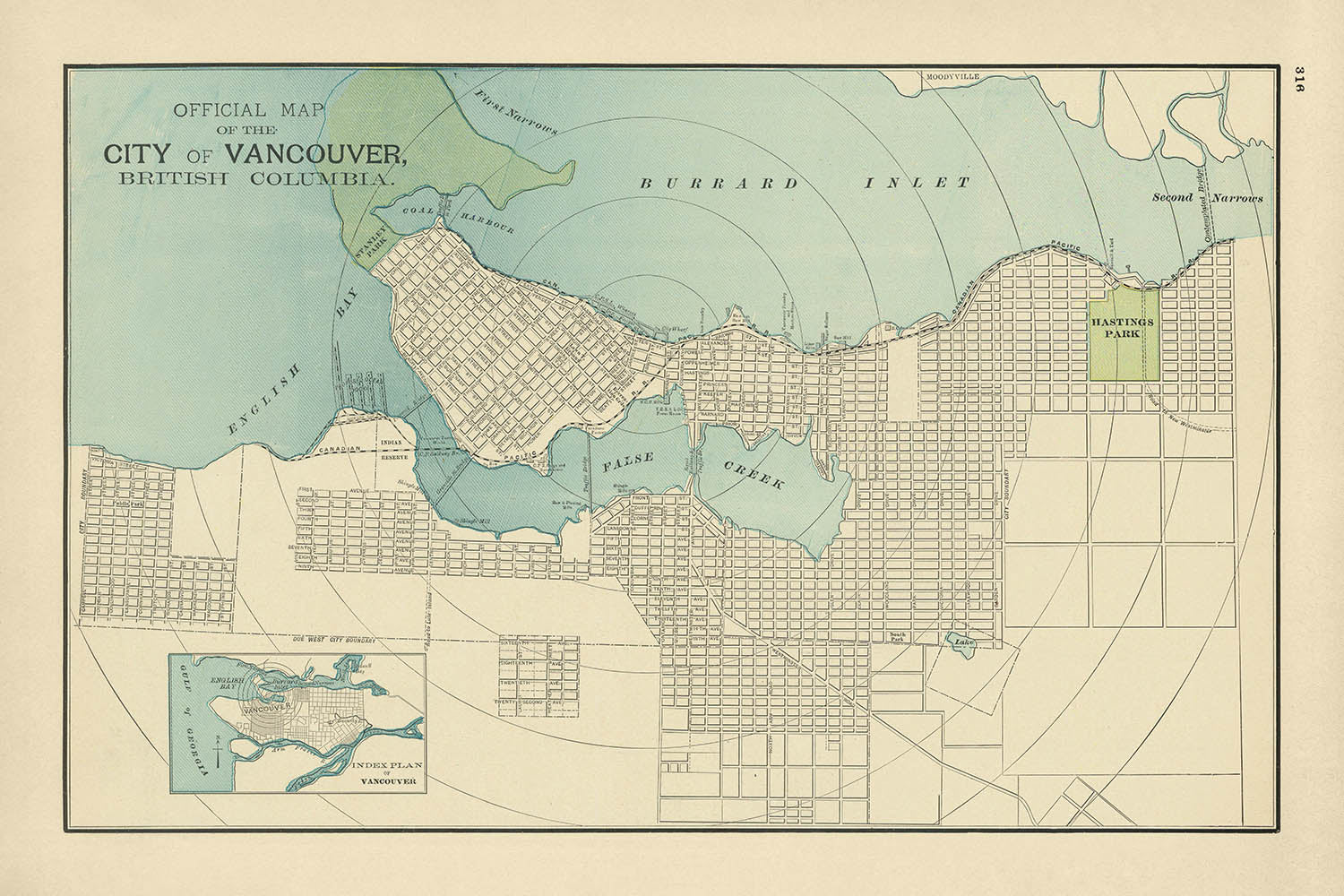
La mappa ufficiale della città di Vancouver, Columbia Britannica, creata nel 1895 dal rinomato cartografo George F. Cram, offre uno sguardo affascinante sul paesaggio urbano e naturale di Vancouver alla fine del XIX secolo. Questa mappa dettagliata evidenzia lo sviluppo crescente della città, incorniciato dalle straordinarie caratteristiche naturali che hanno plasmato la sua identità. Dalla vasta English Bay a ovest al vivace Burrard Inlet a nord, la mappa ritrae vividamente il legame di Vancouver con l'Oceano Pacifico, sottolineando l'importanza della città come hub per il commercio marittimo.
Una delle caratteristiche più sorprendenti di questa mappa è la sua rappresentazione degli spazi verdi di Vancouver, incluso il futuro Stanley Park, una vasta area di natura selvaggia che diventerà uno dei monumenti più iconici della città. A est, Hastings Park è chiaramente etichettato, riflettendo la sua designazione precoce come area ricreativa pubblica. Questi parchi, posti sullo sfondo di una griglia urbana in crescita, illustrano la pianificazione attenta della città e l'impegno a preservare gli spazi naturali in mezzo a uno sviluppo rapido.
Le vie d'acqua su questa mappa sono particolarmente degne di nota, con False Creek che si estende nel cuore della città. Questo inlett non solo serviva come una via d'acqua vitale per il trasporto e l'industria, ma ha anche svolto un ruolo chiave nel plasmare i quartieri circostanti. L'inclusione della Canadian Pacific Railroad, evidenziata, enfatizza ulteriormente il ruolo di Vancouver come nodo di trasporto, collegando la città al resto del Canada e facilitando la sua crescita come grande città portuale.
Questa mappa offre anche uno sguardo affascinante sull'infrastruttura precoce della città e sulla visione per il futuro. Il proposto ponte “second narrows”, che attraversa la parte più stretta di Burrard Inlet, suggerisce la lungimiranza della città nella pianificazione per una maggiore connettività e espansione. Questi dettagli offrono una finestra sulle ambizioni di Vancouver alla fine del XIX secolo, una città pronta per la trasformazione mentre abbracciava il suo ruolo di porta d'accesso al Pacifico e oltre.
La competenza di George F. Cram come cartografo emerge in questa mappa, con il suo design pulito, etichettatura precisa e uso del colore per distinguere le caratteristiche naturali e artificiali. Conosciuto per la sua dedizione all'accuratezza e ai dettagli, il lavoro di Cram rimane altamente apprezzato tra collezionisti e storici. Questa mappa non solo funge da guida pratica per la disposizione di Vancouver nel 1895, ma anche come un'opera d'arte e storia, catturando lo spirito di una città sull'orlo della modernità.
Strade e vie su questa mappa:
- Alexander Street
- Alberni Street
- Burrard Street
- Cambie Street
- Carrall Street
- Cordova Street
- Davie Street
- Denman Street
- Drake Street
- Dunsmuir Street
- Georgia Street
- Granville Street
- Hastings Street
- Howe Street
- Keefer Street
- Main Street
- Nelson Street
- Pender Street
- Powell Street
- Richards Street
- Robson Street
- Seymour Street
- Smythe Street
- Thurlow Street
- Water Street
- Westminster Avenue
- Yaletown Road
- York Street
Caratteristiche e monumenti notevoli:
- Mappe in insetto: Include un piano indice di Vancouver in basso a sinistra, offrendo una visione più ampia della posizione e della disposizione della città.
- Luoghi di interesse:
- Hastings Park: Uno spazio verde pubblico e ricreativo designato.
- Coal Harbour: Un'importante via d'acqua adiacente a Burrard Inlet.
- Grandi parchi:
- Stanley Park (futuro): Rappresentato come una grande area verde nell'angolo nord-ovest della città.
- Hastings Park: Chiaramente contrassegnato come un'area ricreativa chiave.
- Corpi idrici:
- English Bay: Un grande corpo d'acqua a ovest della città.
- False Creek: Un'insenatura prominente che si estende nella città.
- Burrard Inlet: Un'importante via d'acqua a nord, che collega Vancouver all'Oceano Pacifico.
- Infrastrutture proposte: Il ponte "second narrows", che segna i primi piani di connettività attraverso Burrard Inlet.
Contesto storico e di design:
- Cartografo: Creato da George F. Cram, un rinomato cartografo del XIX secolo celebrato per le sue mappe dettagliate e accurate.
- Pianificazione urbana: Sottolinea la lungimiranza di Vancouver nel preservare spazi verdi come Stanley Park e Hastings Park in mezzo all'espansione urbana.
- Focus sui trasporti: Sottolinea il ruolo della Canadian Pacific Railroad e delle connessioni marittime nella formazione della crescita di Vancouver.
- Stile di design: Presenta linee pulite, etichette precise e un uso attento del colore per distinguere elementi naturali e urbani.
- Significato storico: Cattura Vancouver in un momento cruciale della sua storia, mostrando la sua transizione in una città moderna e interconnessa.
- Importanza geografica: Rappresenta l'integrazione di Vancouver con vie d'acqua chiave e la sua posizione strategica come porta d'accesso al Pacifico.
Si prega di controllare attentamente le immagini per assicurarsi che una specifica città o luogo sia mostrato su questa mappa. Puoi anche contattarci e chiedere di controllare la mappa per te.
Questa mappa appare fantastica in ogni dimensione, ma consiglio sempre di optare per una dimensione più grande se hai spazio. In questo modo puoi facilmente distinguere tutti i dettagli.
Questa mappa sembra straordinaria in dimensioni fino a 70in (180cm). Se stai cercando una mappa più grande, per favore contattaci.
Il modello nelle immagini dell'annuncio tiene la versione 24x36in (60x90cm) di questa mappa.
La quinta immagine dell'annuncio mostra un esempio del mio servizio di personalizzazione della mappa.
Se stai cercando qualcosa di leggermente diverso, dai un'occhiata alla mia collezione delle migliori mappe antiche per vedere se qualcosa attira la tua attenzione.
Si prega di contattarmi per controllare se una certa posizione, punto di riferimento o caratteristica è mostrato su questa mappa.
Questo sarebbe un meraviglioso regalo di compleanno, Natale, Festa del Papà, partenza dal lavoro, anniversario o regalo di inaugurazione per qualcuno delle aree coperte da questa mappa.
Questa mappa è disponibile come stampa giclée su carta opaca archiviata senza acidi, oppure puoi acquistarla incorniciata. La cornice è una bella e semplice cornice nera che si adatta alla maggior parte degli stili. Ti preghiamo di contattarci se desideri un colore o un materiale diverso per la cornice. Le mie cornici sono rivestite con un acrilico super chiaro di qualità museale (perspex/acrylite), che è significativamente meno riflettente del vetro, più sicuro e arriverà sempre in perfette condizioni.
This map is also available as a float framed canvas, sometimes known as a shadow gap framed canvas or canvas floater. The map is printed on artist's cotton canvas and then stretched over a handmade box frame. We then "float" the canvas inside a wooden frame, which is available in a range of colours (black, dark brown, oak, antique gold and white). This is a wonderful way to present a map without glazing in front. See some examples of float framed canvas maps and explore the differences between my different finishes.
For something truly unique, this map is also available in "Unique 3D", our trademarked process that dramatically transforms the map so that it has a wonderful sense of depth. We combine the original map with detailed topography and elevation data, so that mountains and the terrain really "pop". For more info and examples of 3D maps, check my Unique 3D page.
Many of our maps and art prints are chosen as thoughtful gifts for homes, offices, studies and meaningful places.
Choose a framed option for the easiest ready-to-hang gift, or choose an unframed print if the recipient may prefer to select their own frame.
We make orders locally in 23 countries around the world, so gifts can often be produced close to the recipient. This helps them arrive faster, travel more safely, and avoid customs or import duty surprises.
- We can deliver directly to the recipient
- Framed pieces arrive ready to hang
- Unframed prints are carefully packed in a strong protective tube
- Almost every order is made locally, for faster, safer gifting
- 90-day returns give the recipient time to decide
If you are not sure what to choose, please contact us. We can help you pick the right map, size, finish or delivery option.
Most orders are made locally and delivered in around 2–3 working days, depending on the product, size and destination.
We print and frame maps and artwork in 23 countries around the world, so your order is usually made close to you or your recipient. That means faster delivery, less time in transit, and no customs or import duty surprises.
Personalised and customised pieces usually take an extra 1–2 working days, because we prepare your design and send it to you for approval before printing.
Very large framed orders can take a little longer, as they need extra care in production and delivery.
Every order is carefully packaged: unframed prints are sent in a strong protective tube, while framed pieces are securely packed with protective materials around the frame.
If you need your order by a particular date, please contact us before ordering. We’ll check the best production route and delivery option for your location.
Express delivery is available at checkout for most countries. Next-day delivery is available in the UK, US, Singapore and the UAE.
Your order is covered by our 90-day returns policy and 10-year guarantee.
Our standard frame is a gallery-style black ash hardwood frame, with a simple, modern look. It is approximately 20mm (0.8in) wide. You can also view some lovely customer photos of framed maps and art.
We use super-clear acrylic glazing, also known as Perspex or Acrylite, instead of traditional glass. It is lighter, safer, and has lower reflectivity, giving the artwork a clearer, cleaner appearance.
Six standard frame colours are available at no extra cost: black, dark brown, dark grey, oak, white, and antique gold. Custom framing and mounting/matting is also available for customers looking for something more specific.
Most maps, art prints, and illustrations are also available as a framed canvas. We use matte cotton canvas, stretch it over a sustainably sourced wooden box frame, and then float the piece within a wooden outer frame. The finished result is beautifully presented, with no glazing between you and the artwork.
All frames are supplied ready to hang, with either string or brackets fitted to the back. Very large frames will include heavy-duty hanging plates and/or a mounting baton. If you have any questions, please get in touch.
We can also supply old maps and artwork on canvas, foam board, cotton rag, and other materials.
If you would prefer to frame your map or artwork yourself, please read our size guide before ordering.
My maps are extremely high quality reproductions of original maps.
I source original, rare maps from libraries, auction houses and private collections around the world, restore them at my London workshop, and then use specialist giclée inks and printers to create beautiful maps that look even better than the original.
My maps are printed on acid-free archival matte (not glossy) paper that feels very high quality and almost like card. In technical terms the paper weight/thickness is 10mil/200gsm. It's perfect for framing.
I print with Epson ultrachrome giclée UV fade resistant pigment inks - some of the best inks you can find.
I can also make maps on canvas, cotton rag and other exotic materials.
Learn more about The Unique Maps Co.
Map personalisation
If you're looking for the perfect anniversary or housewarming gift, I can personalise your map to make it truly unique. For example, I can add a short message, or highlight an important location, or add your family's coat of arms.
The options are almost infinite. Please see my map personalisation page for some wonderful examples of what's possible.
To order a personalised map, select "personalise your map" before adding it to your basket.
Get in touch if you're looking for more complex customisations and personalisations.
Map ageing
I have been asked hundreds of times over the years by customers if they could buy a map that looks even older.
Well, now you can, by selecting Aged before you add a map to your basket.
All the product photos you see on this page show the map in its Original form. This is what the map looks like today.
If you select Aged, I will age your map by hand, using a special and unique process developed through years of studying old maps, talking to researchers to understand the chemistry of aging paper, and of course... lots of practice!
If you're unsure, stick to the Original colour of the map. If you want something a bit darker and older looking, go for Aged.
Se non sei soddisfatto del tuo ordine per qualsiasi motivo, contattami per un rimborso senza problemi. Si prega di consultare la nostra politica di reso e rimborso per ulteriori informazioni.
Sono molto sicuro che ti piacerà la tua mappa restaurata o la stampa d'arte. Lo faccio dal 1984. Sono un venditore Etsy a 5 stelle. Ho venduto decine di migliaia di mappe e stampe d'arte e ho oltre 5.000 recensioni reali a 5 stelle.
Utilizzo un processo unico per restaurare mappe e opere d'arte che richiede molto tempo e lavoro. Trovare le mappe e le illustrazioni originali può richiedere mesi. Utilizzo tecnologia all'avanguardia e incredibilmente costosa per scannerizzare e restaurarle. Di conseguenza, garantisco che le mie mappe e stampe d'arte siano superiori alle altre - ecco perché posso offrire un rimborso senza problemi.
Quasi tutte le mie mappe e stampe d'arte sembrano fantastiche a grandi dimensioni (200 cm, 6,5 piedi+) e posso anche incorniciarle e consegnarle a te, tramite un corriere speciale per oggetti di grandi dimensioni. Contattami per discutere delle tue esigenze specifiche.
Or try searching for something!


