

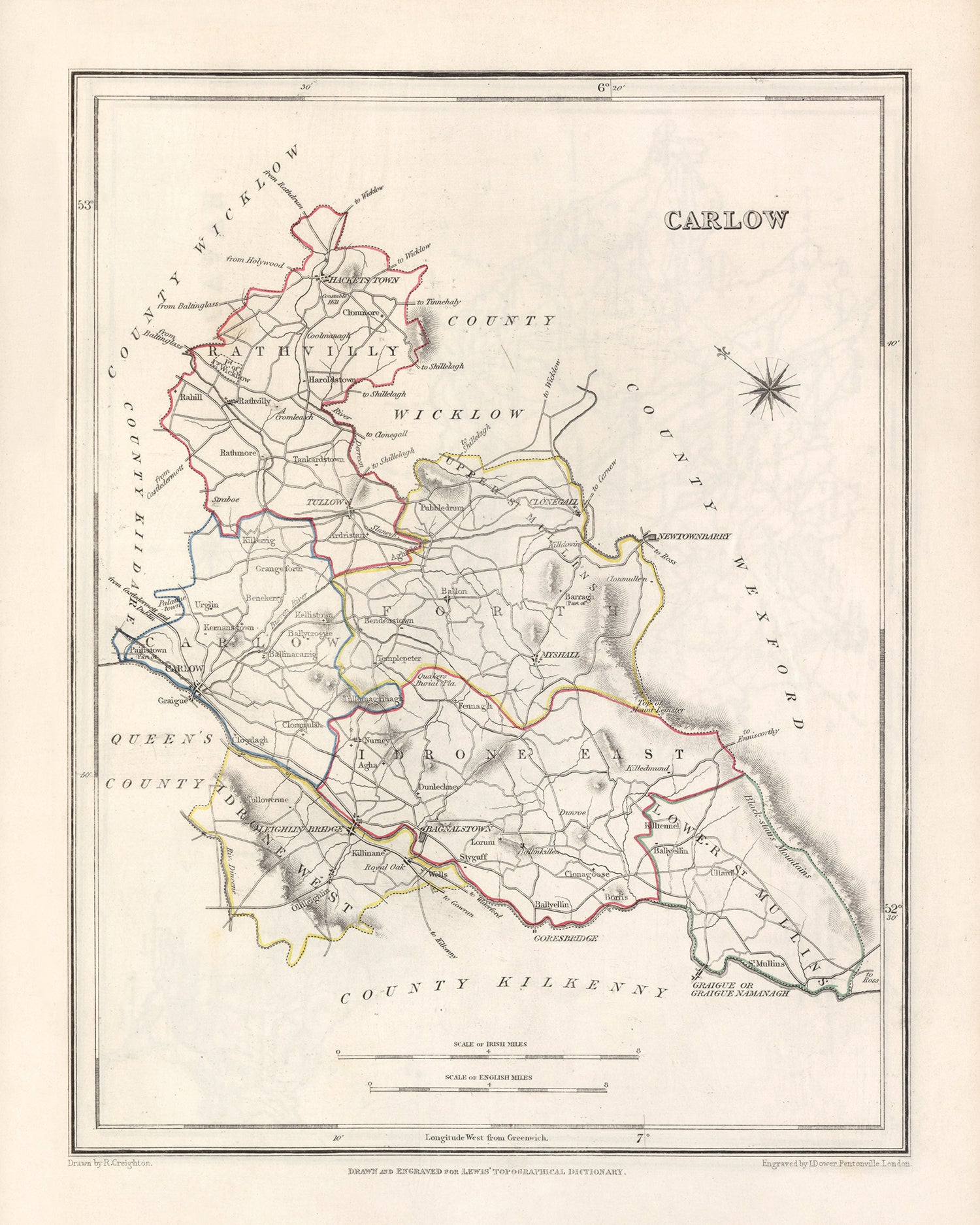


Mappa antica della Contea di Carlow di Samuel Lewis, 1844: Tullow, Hacketstown, Leighlinbridge, Rathvilly, Myshall
20% di sconto su 2 — 33% di sconto su 3
Aggiungi qualsiasi due articoli idonei al tuo carrello per ricevere 20% di sconto. Aggiungi un terzo e sarà gratuito (equivalente a 33% di sconto quando acquisti tre).
Nessun codice necessario — l'offerta si applica automaticamente al checkout.
Valido su tutte le mappe standard e le stampe d'arte fine. Puoi mescolare e abbinare qualsiasi design.
Se desideri spedire articoli a più indirizzi, ti preghiamo di contattarci prima di effettuare il tuo ordine.
Le commissioni personalizzate e su misura sono escluse.
Contattaci se hai domande
 Progettato a Londra Prodotto in Canada
Progettato a Londra • Prodotto in Canada
Progettato a Londra Prodotto in Canada
Progettato a Londra • Prodotto in Canada

Choose your size
Choose your finish


(Maggiori informazioni)
Gift message & custom finish

If you want to add a gift message, or a finish (jigsaw, aluminium board, etc.) that is not available here, please request it in the "order note" when you check out.
Every order is custom made, so if you need the size adjusted slightly, or printed on an unusual material, just let us know. We've done thousands of custom orders over the years, so there's (almost) nothing we can't manage.
You can also contact us before you order, if you prefer!

- Made locally for fast, safe delivery
- No import duty or hidden fees
- Need advice? Message us on WhatsApp
Own a piece of history
7,000+ 5 star reviews


La vecchia mappa di Carlow di Samuel Lewis, datata 1844, è un’opera affascinante che offre uno sguardo sul paesaggio storico della contea di Carlow, in Irlanda. Questa mappa, realizzata con minuziosa cura, mette in mostra i dettagli intricati della regione, presentando una prospettiva affascinante dell’area a metà del XIX secolo. Come pregiato pezzo da collezione, questa mappa possiede un immenso valore storico e costituisce un notevole elemento decorativo per gli appassionati di cartografia e del patrimonio irlandese.
Esplorando questa mappa, occorre tenere presente che alcune città moderne potrebbero non essere presenti, oppure potrebbero comparire con nomi precedenti, aggiungendo un elemento di emozione e scoperta. La vecchia mappa di Carlow offre un’opportunità unica di osservare l’evoluzione degli insediamenti e dei punti di riferimento nel tempo, offrendo un’esperienza arricchente per gli appassionati di storia e per coloro che hanno un profondo legame con la regione.
Insediamenti notevoli e date di fondazione
- Carlow (ca. 600 d.C.): la città capoluogo della contea di Carlow, nota per la sua ricca storia e il suo patrimonio architettonico.
- Tullow (ca. 400 d.C.): una vivace cittadina di mercato con una lunga storia, circondata da una splendida campagna.
- Hacketstown (ca. 1600 d.C.): un pittoresco villaggio adagiato ai piedi delle Wicklow Mountains, rinomato per il suo fascino paesaggistico.
- Leighlinbridge (ca. 1180 d.C.): sede dello storico castello di Leighlinbridge, questo villaggio offre un delizioso connubio di storia e bellezza naturale.
- Rathvilly (ca. 1600 d.C.): un villaggio grazioso noto per la sua atmosfera tranquilla e l’imponente castello di Rathvilly.
- Myshall (ca. 1600 d.C.): un piccolo villaggio con un ricco patrimonio agricolo, situato tra gli splendidi paesaggi delle Blackstairs Mountains.
L’elenco prosegue con i seguenti insediamenti notevoli fondati prima del 1840:
- Bagenalstown (ca. 1660 d.C.): una pittoresca cittadina con un affascinante passato industriale, situata sul fiume Barrow.
- Fenagh (ca. 1600 d.C.): un grazioso villaggio rinomato per i suoi siti storici, tra cui le rovine dell’abbazia di Fenagh.
- Clonegal (ca. 1600 d.C.): un villaggio incantevole con un forte senso di comunità, circondato da una rigogliosa vegetazione.
- Rathoe (ca. 1600 d.C.): un villaggio tranquillo intriso di storia, che vanta l’imponente castello di Rathoe.
- Ballon (ca. 1600 d.C.): un pittoresco villaggio adagiato tra dolci colline, che offre un rifugio tranquillo.
- Kildavin (ca. 1600 d.C.): un piccolo villaggio noto per il suo ambiente idilliaco e l’antica croce di Kildavin.
- Fennagh (ca. 1600 d.C.): un villaggio sereno rinomato per i suoi splendidi paesaggi e Fennagh House.
- Rathanna (ca. 1600 d.C.): un villaggio grazioso con una comunità molto unita, circondato da una campagna panoramica.
- Nurney (ca. 1600 d.C.): un villaggio incantevole con un ricco patrimonio agricolo, situato vicino al fiume Griese.
- Ardattin (ca. 1600 d.C.): un villaggio tranquillo noto per i suoi dintorni pittoreschi e la chiesa di Ardattin.
- St. Mullins (ca. 600 d.C.): un villaggio storico situato sulle rive del fiume Barrow, sede del sito monastico di St. Mullins.
- Killeshin (ca. 600 d.C.): un villaggio intriso di storia, che vanta l’imponente chiesa di Killeshin e la torre rotonda.
- Fenagh (ca. 600 d.C.): un villaggio dalle antiche origini, con le rovine dell’abbazia di Fenagh e un ricco patrimonio celtico.
- Kernanstown (ca. 600 d.C.): un piccolo villaggio con un forte senso di comunità, circondato da paesaggi scenografici.
- Borris (ca. 1600 d.C.): un villaggio pittoresco rinomato per la splendida Borris House e per la bella campagna circostante.
- Rathvilly (c. 600 CE): Un villaggio con una lunga storia, sede dell'imponente Castello di Rathvilly e della Chiesa di Rathvilly.
- Aghade (c. 600 CE): Un villaggio tranquillo noto per la sua bellezza paesaggistica e l'antica Aghade Holed Stone.
- Clonmore (c. 600 CE): Un villaggio intriso di storia, che presenta le rovine del Castello di Clonmore e della Chiesa di Clonmore.
- Old Leighlin (c. 600 CE): Un villaggio con un ricco patrimonio ecclesiastico, che ospita la storica Cattedrale di Old Leighlin.
- Ballymurphy (c. 600 CE): Un villaggio affascinante immerso nella campagna, che offre un rifugio tranquillo.
- Rathanna (c. 600 CE): Un villaggio grazioso noto per la sua comunità unita e i dintorni scenografici.
- Fennagh (c. 600 CE): Un villaggio sereno rinomato per i suoi splendidi paesaggi e Fennagh House.
- Nurney (c. 600 CE): Un villaggio affascinante con un ricco patrimonio agricolo, situato vicino al fiume Griese.
- Ardattin (c. 600 CE): Un villaggio tranquillo noto per i suoi dintorni pittoreschi e la Chiesa di Ardattin.
Caratteristiche naturali e eventi storici notevoli
Tra le caratteristiche naturali, i confini e gli eventi storici notevoli nella contea di Carlow tra il 1800 e il 1850 figurano:
- Fiume Barrow: Un maestoso fiume che attraversa la contea, offrendo bellezze paesaggistiche e attività ricreative.
- Monti Blackstairs: Una straordinaria catena montuosa situata nella parte sudorientale della contea, che offre panorami mozzafiato e opportunità di esplorazione all'aperto.
- Castello di Carlow: Un punto di riferimento storico nella città di Carlow, che ricorda il passato medievale della regione.
- Ribellione del 1798: Un evento significativo nella storia irlandese, con la contea di Carlow che ebbe un ruolo nella ribellione contro il dominio britannico.
- Cattedrale di Carlow: Una magnifica cattedrale nella città di Carlow, che mette in mostra un'architettura imponente e un significato religioso.
Immergetevi nella ricca storia e nella bellezza affascinante della contea di Carlow con la Mappa antica di Carlow di Samuel Lewis, 1844. Questa straordinaria mappa vi permette di seguire le orme del passato, esplorando gli insediamenti, i luoghi notevoli e le meraviglie naturali che hanno plasmato questa regione straordinaria.
Controllate attentamente le immagini per assicurarvi che una specifica città o località sia presente su questa mappa. Potete anche contattarci e chiederci di verificare la mappa per voi.
Questa mappa ha un aspetto magnifico in tutte le dimensioni: 12x16in (30.5x41cm), 16x20in (40.5x51cm), 18x24in (45.5x61cm), 24x30in (61x76cm), 32x40in (81.5x102cm) e 40x50in (102x127cm), ma è ancora più bella se stampata in grande formato.
Posso realizzare splendide stampe di grandi dimensioni di questa mappa fino a 50in (127cm). Contattatemi se cercate dimensioni maggiori, personalizzazioni o diverse opzioni di cornice.
La modella nelle immagini dell'inserzione tiene in mano la versione 16x20in (40.5x51cm) di questa mappa.
La quinta immagine dell'inserzione mostra un esempio del mio servizio di personalizzazione delle mappe.
Se cercate qualcosa di leggermente diverso, date un'occhiata alla mia principale collezione di mappe del Regno Unito e dell'Irlanda.
Vi prego di contattarmi per verificare se una certa località, punto di riferimento o elemento è presente su questa mappa.
Sarebbe un meraviglioso regalo di compleanno, Natale, Festa del papà, per un collega che lascia il lavoro, anniversario o inaugurazione casa per qualcuno proveniente dalle aree coperte da questa mappa.
Questa mappa è disponibile come stampa giclée su carta opaca archivistica senza acidi, oppure è possibile acquistarla già incorniciata. La cornice è elegante e semplice, di colore nero, adatta alla maggior parte degli ambienti. Contattateci se desiderate un colore o un materiale diverso per la cornice. Le mie cornici sono protette da acrilico trasparente di qualità museale (perspex/acrylite), significativamente meno riflettente del vetro, più sicuro e che arriverà sempre in condizioni perfette.
This map is also available as a float framed canvas, sometimes known as a shadow gap framed canvas or canvas floater. The map is printed on artist's cotton canvas and then stretched over a handmade box frame. We then "float" the canvas inside a wooden frame, which is available in a range of colours (black, dark brown, oak, antique gold and white). This is a wonderful way to present a map without glazing in front. See some examples of float framed canvas maps and explore the differences between my different finishes.
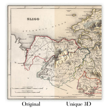
For something truly unique, this map is also available in "Unique 3D", our trademarked process that dramatically transforms the map so that it has a wonderful sense of depth. We combine the original map with detailed topography and elevation data, so that mountains and the terrain really "pop". For more info and examples of 3D maps, check my Unique 3D page.
Many of our maps and art prints are chosen as thoughtful gifts for homes, offices, studies and meaningful places.
Choose a framed option for the easiest ready-to-hang gift, or choose an unframed print if the recipient may prefer to select their own frame.
We make orders locally in 23 countries around the world, so gifts can often be produced close to the recipient. This helps them arrive faster, travel more safely, and avoid customs or import duty surprises.
- We can deliver directly to the recipient
- Framed pieces arrive ready to hang
- Unframed prints are carefully packed in a strong protective tube
- Almost every order is made locally, for faster, safer gifting
- 90-day returns give the recipient time to decide
If you are not sure what to choose, please contact us. We can help you pick the right map, size, finish or delivery option.
Most orders are made locally and delivered in around 2–3 working days, depending on the product, size and destination.
We print and frame maps and artwork in 23 countries around the world, so your order is usually made close to you or your recipient. That means faster delivery, less time in transit, and no customs or import duty surprises.
Personalised and customised pieces usually take an extra 1–2 working days, because we prepare your design and send it to you for approval before printing.
Very large framed orders can take a little longer, as they need extra care in production and delivery.
Every order is carefully packaged: unframed prints are sent in a strong protective tube, while framed pieces are securely packed with protective materials around the frame.
If you need your order by a particular date, please contact us before ordering. We’ll check the best production route and delivery option for your location.
Express delivery is available at checkout for most countries. Next-day delivery is available in the UK, US, Singapore and the UAE.
Your order is covered by our 90-day returns policy and 10-year guarantee.
Our standard frame is a gallery-style black ash hardwood frame, with a simple, modern look. It is approximately 20mm (0.8in) wide. You can also view some lovely customer photos of framed maps and art.
We use super-clear acrylic glazing, also known as Perspex or Acrylite, instead of traditional glass. It is lighter, safer, and has lower reflectivity, giving the artwork a clearer, cleaner appearance.
Six standard frame colours are available at no extra cost: black, dark brown, dark grey, oak, white, and antique gold. Custom framing and mounting/matting is also available for customers looking for something more specific.
Most maps, art prints, and illustrations are also available as a framed canvas. We use matte cotton canvas, stretch it over a sustainably sourced wooden box frame, and then float the piece within a wooden outer frame. The finished result is beautifully presented, with no glazing between you and the artwork.
All frames are supplied ready to hang, with either string or brackets fitted to the back. Very large frames will include heavy-duty hanging plates and/or a mounting baton. If you have any questions, please get in touch.
We can also supply old maps and artwork on canvas, foam board, cotton rag, and other materials.
If you would prefer to frame your map or artwork yourself, please read our size guide before ordering.
My maps are extremely high quality reproductions of original maps.
I source original, rare maps from libraries, auction houses and private collections around the world, restore them at my London workshop, and then use specialist giclée inks and printers to create beautiful maps that look even better than the original.
My maps are printed on acid-free archival matte (not glossy) paper that feels very high quality and almost like card. In technical terms the paper weight/thickness is 10mil/200gsm. It's perfect for framing.
I print with Epson ultrachrome giclée UV fade resistant pigment inks - some of the best inks you can find.
I can also make maps on canvas, cotton rag and other exotic materials.
Learn more about The Unique Maps Co.
Map personalisation
If you're looking for the perfect anniversary or housewarming gift, I can personalise your map to make it truly unique. For example, I can add a short message, or highlight an important location, or add your family's coat of arms.
The options are almost infinite. Please see my map personalisation page for some wonderful examples of what's possible.
To order a personalised map, select "personalise your map" before adding it to your basket.
Get in touch if you're looking for more complex customisations and personalisations.
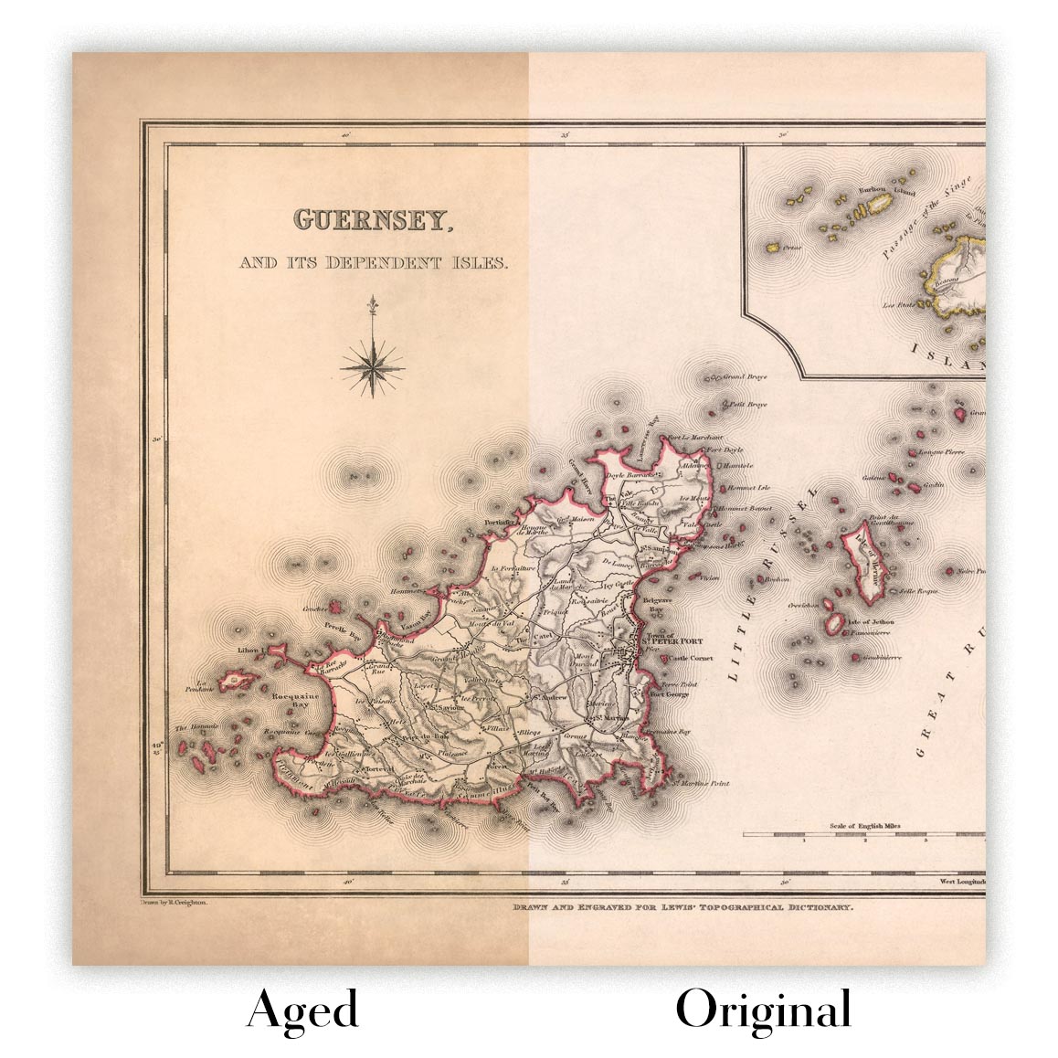
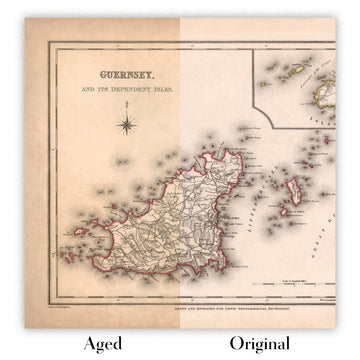
Map ageing
I have been asked hundreds of times over the years by customers if they could buy a map that looks even older.
Well, now you can, by selecting Aged before you add a map to your basket.
All the product photos you see on this page show the map in its Original form. This is what the map looks like today.
If you select Aged, I will age your map by hand, using a special and unique process developed through years of studying old maps, talking to researchers to understand the chemistry of aging paper, and of course... lots of practice!
If you're unsure, stick to the Original colour of the map. If you want something a bit darker and older looking, go for Aged.
Se non sei soddisfatto del tuo ordine per qualsiasi motivo, contattami per un rimborso senza problemi. Si prega di consultare la nostra politica di reso e rimborso per ulteriori informazioni.
Sono molto sicuro che ti piacerà la tua mappa restaurata o la stampa d'arte. Lo faccio dal 1984. Sono un venditore Etsy a 5 stelle. Ho venduto decine di migliaia di mappe e stampe d'arte e ho oltre 5.000 recensioni reali a 5 stelle.
Utilizzo un processo unico per restaurare mappe e opere d'arte che richiede molto tempo e lavoro. Trovare le mappe e le illustrazioni originali può richiedere mesi. Utilizzo tecnologia all'avanguardia e incredibilmente costosa per scannerizzare e restaurarle. Di conseguenza, garantisco che le mie mappe e stampe d'arte siano superiori alle altre - ecco perché posso offrire un rimborso senza problemi.
Quasi tutte le mie mappe e stampe d'arte sembrano fantastiche a grandi dimensioni (200 cm, 6,5 piedi+) e posso anche incorniciarle e consegnarle a te, tramite un corriere speciale per oggetti di grandi dimensioni. Contattami per discutere delle tue esigenze specifiche.
Or try searching for something!


