

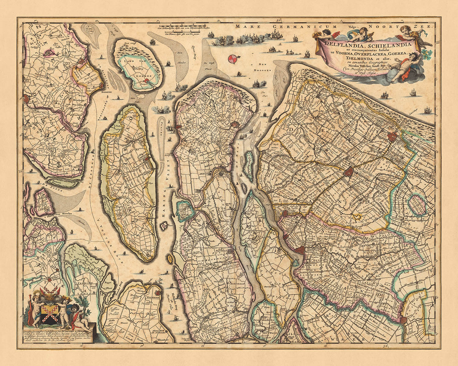


Mappa antica di Delfland e Schieland di Visscher, 1690: L'Aia, Rotterdam, Delft, Hellevoetsluis, Ridderkerk
20% di sconto su 2 — 33% di sconto su 3
Aggiungi qualsiasi due articoli idonei al tuo carrello per ricevere 20% di sconto. Aggiungi un terzo e sarà gratuito (equivalente a 33% di sconto quando acquisti tre).
Nessun codice necessario — l'offerta si applica automaticamente al checkout.
Valido su tutte le mappe standard e le stampe d'arte fine. Puoi mescolare e abbinare qualsiasi design.
Se desideri spedire articoli a più indirizzi, ti preghiamo di contattarci prima di effettuare il tuo ordine.
Le commissioni personalizzate e su misura sono escluse.
Contattaci se hai domande
 Progettato a Londra Prodotto in Canada
Progettato a Londra • Prodotto in Canada
Progettato a Londra Prodotto in Canada
Progettato a Londra • Prodotto in Canada

Choose your size
Choose your finish


(Maggiori informazioni)
Gift message & custom finish

If you want to add a gift message, or a finish (jigsaw, aluminium board, etc.) that is not available here, please request it in the "order note" when you check out.
Every order is custom made, so if you need the size adjusted slightly, or printed on an unusual material, just let us know. We've done thousands of custom orders over the years, so there's (almost) nothing we can't manage.
You can also contact us before you order, if you prefer!

- Made locally for fast, safe delivery
- No import duty or hidden fees
- Need advice? Message us on WhatsApp
Own a piece of history
7,000+ 5 star reviews


Questo straordinario pezzo di storia è una vecchia mappa di Delfland e Schieland, meticolosamente realizzata da Nicolaes Visscher II nel 1690. Come parte del Secolo d'Oro olandese, le mappe di Visscher erano rinomate per la loro precisione e attenzione ai dettagli, e questa mappa non fa eccezione. Il nome completo della mappa, 'Delflandia, Schielandia et circumjacentes insulae ut Voorna, Overflackae, Goerae, Yselmonda et aliae', si traduce in 'Delfland, Schieland e le isole circostanti come Voorne, Overflakkee, Goeree, IJsselmonde e altre'. Questo fornisce un chiaro indicativo delle regioni e delle divisioni politiche che la mappa copre, che è principalmente l'area moderna dei Paesi Bassi.
La mappa presenta in modo prominente cinque località notevoli: L'Aia, Rotterdam, Delft, Hellevoetsluis e Ridderkerk. Ognuna di queste città ha una storia ricca e ha svolto ruoli significativi nello sviluppo dei Paesi Bassi. L'Aia, ad esempio, è la sede del governo olandese e del Re, mentre Rotterdam, con la sua posizione strategica lungo il delta Reno-Mosa-Schelda, è stata un importante centro logistico ed economico per secoli.
Delft, una città conosciuta per il suo centro storico con canali, è anche evidenziata su questa mappa. È famosa per la sua associazione con la famiglia reale olandese, la Casa di Orange-Nassau. Hellevoetsluis, una piccola città situata sul Haringvliet, era una base principale per la marina olandese durante il Secolo d'Oro olandese. Infine, Ridderkerk, una città situata nei Paesi Bassi occidentali, nella provincia dell'Olanda Meridionale, è anch'essa rappresentata su questa mappa.
Il lascito della famiglia Visscher nella cartografia è evidente in quest'opera. Il dettaglio e la precisione con cui hanno catturato la topografia e i confini politici dell'epoca sono una testimonianza della loro abilità e del ruolo significativo che hanno svolto nella cartografia del Secolo d'Oro olandese. Questa mappa non è solo un'opera d'arte; è una finestra sul passato, fornendo un'idea del paesaggio geografico e politico dei Paesi Bassi alla fine del XVII secolo.
Alcune delle località significative mostrate su questa mappa:
Delfland
- L'Aia (Den Haag): Conosciuta come 's-Gravenhage in olandese, è la sede del governo olandese e del Re. Fondata nel 1230.
- Delft: Famosa per il suo centro storico con canali e la sua associazione con la famiglia reale olandese, la Casa di Orange-Nassau. Fondata nel 1075.
- Vlaardingen: Conosciuta per la sua industria della pesca dell'aringa nel Medioevo. Fondata nel 700.
- Schiedam: Conosciuta per i suoi storici mulini a vento, alcuni dei più grandi del mondo. Fondata nel 1230.
- Maassluis: Un importante porto durante il Secolo d'Oro olandese. Fondata nel 1340.
- Naaldwijk: Il centro amministrativo della regione del Westland. Fondata nel 1230.
- Monster: Conosciuta per la sua lunga spiaggia sabbiosa lungo il Mare del Nord. Fondata nel 1204.
- De Lier: Conosciuta per la sua orticoltura e industria floreale. Fondata nel 1282.
- Wateringen: Conosciuta per il suo storico mulino a vento, De Windlust. Fondata nel 1156.
- Poeldijk: Conosciuta per la sua storica chiesa cattolica romana, la Bartholomeuskerk. Fondata nel 1200.
Schieland
- Rotterdam: Un importante centro logistico ed economico, noto per la sua posizione strategica lungo il delta Reno-Mosa-Schelda. Fondata nel 1270.
- Gouda : Conosciuta per il suo formaggio, le pipe da fumo e il municipio del XV secolo. Fondata nel 1139.
- Schoonhoven: Conosciuta come la Città dell'Argento a causa della sua storica industria dell'argento. Fondata nel 1220.
- Capelle aan den IJssel: Conosciuta per il suo storico mulino a vento, De Windlust. Fondata nel 1271.
- Nieuwerkerk aan den IJssel: Conosciuta per avere il punto più basso nei Paesi Bassi. Fondata nel 1250.
- Krimpen aan den IJssel: Conosciuta per la sua storica barriera contro le maree, l'Hollandsche IJsselkering. Fondata nel 1274.
- Moordrecht: Conosciuta per le sue storiche chiese, come la Hervormde kerk. Fondata nel 1260.
- Bergambacht: Conosciuta per la sua tradizionale fattoria di formaggi, la Boerderij de Jong. Fondata nel 1240.
- Lekkerkerk: Conosciuta per la sua posizione lungo il fiume Lek. Fondata nel 1282.
- Krimpen aan de Lek: Conosciuta per il suo storico cantiere navale, il Royal IHC. Fondata nel 1277.
Isole Circostanti
- Hellevoetsluis: Una base importante per la marina olandese durante l'età dell'oro olandese. Fondata nel 1312.
- Ridderkerk: Conosciuta per la sua storica chiesa riformata. Fondata nel 1040.
- Brielle: Conosciuta per le sue fortificazioni ben conservate. Fondata nel 1306.
- Spijkenisse: Conosciuta per la sua architettura moderna, come il Boekenberg. Fondata nel 1231.
- Goedereede: Conosciuta per il suo storico faro. Fondata nel 1312.
- Middelharnis: Conosciuta per il suo storico porto. Fondata nel 1465.
- Dirksland: Conosciuta per il suo storico ospedale, l'Ospedale Van Weel-Bethesda. Fondata nel 1412.
- Ouddorp: Conosciuta per la sua lunga spiaggia sabbiosa lungo il Mare del Nord. Fondata nel 1305.
- Ooltgensplaat: Conosciuta per la sua storica fortezza, il Fort Prins Frederik. Fondata nel 1313.
- Nieuwe-Tonge: Conosciuta per il suo storico mulino a vento, il Battenoord. Fondata nel 1482.
Confini Notabili e Fenomeni Naturali
- Delta del Reno-Mosa-Schelda: Un importante delta fluviale nei Paesi Bassi formato dalla confluenza dei fiumi Reno, Mosa e Schelda.
- Haringvliet: Un grande golfo del Mare del Nord e un corpo d'acqua significativo nei Paesi Bassi.
- Parco Nazionale Biesbosch: Uno dei più grandi parchi nazionali nei Paesi Bassi e una delle ultime aree estese di zone umide di acqua dolce in Europa nord-occidentale.
- Il Maeslantkering: Una barriera contro le maree sulla Nieuwe Waterweg, parte dei Delta Works.
- Il Porto Storico di Rotterdam: Conosciuto come il porto più grande d'Europa.
Eventi Storici Notabili (1600-1690)
- Il Secolo d'Oro Olandese (XVII secolo): Un periodo nella storia olandese, tipicamente associato al successo commerciale e artistico, durante il quale la Repubblica Olandese era una delle potenze mondiali principali.
- La Guerra dei Trent'Anni (1568–1648): Una rivolta delle Diciassette Province contro l'egemonia politica e religiosa di Filippo II di Spagna, il sovrano dei Paesi Bassi asburgici.
- Anno Disastroso (1672) : Conosciuto nella storia olandese come il Rampjaar, quando la Repubblica Olandese fu attaccata simultaneamente da Inghilterra, Francia e dai Vescovadi di Münster e Colonia.
Si prega di controllare attentamente le immagini per assicurarsi che una specifica città o luogo sia mostrato su questa mappa. Puoi anche metterti in contatto e chiedere di controllare la mappa per te.
Questa mappa appare fantastica in tutte le dimensioni: 12x16in (30.5x41cm), 16x20in (40.5x51cm), 18x24in (45.5x61cm), 24x30in (61x76cm), 32x40in (81.5x102cm), 40x50in (102x127cm), 48x60in (122x153cm) e 56x70in (142x178cm), ma appare ancora meglio quando stampata in grande.
Posso creare stampe bellissime e grandi di questa mappa fino a 90in (229cm). Ti prego di contattarmi se stai cercando opzioni di incorniciatura più grandi, personalizzate o diverse.
Il modello nelle immagini dell'annuncio tiene la versione 16x20in (40.5x51cm) di questa mappa.
La quinta immagine dell'annuncio mostra un esempio del mio servizio di personalizzazione della mappa.
Se stai cercando qualcosa di leggermente diverso, dai un'occhiata alla mia collezione delle migliori vecchie mappe d'Europa e delle città europee per vedere se qualcosa attira la tua attenzione.
Ti prego di contattarmi per verificare se una certa posizione, punto di riferimento o caratteristica è mostrata su questa mappa.
Questa sarebbe una meravigliosa idea regalo per un compleanno, Natale, Festa del Papà, addio al lavoro, anniversario o inaugurazione di una casa per qualcuno delle aree coperte da questa mappa.
Questa mappa è disponibile come stampa giclée su carta opaca archiviata senza acidi, oppure puoi acquistarla incorniciata. La cornice è una semplice cornice nera che si adatta alla maggior parte degli stili. Ti prego di contattarmi se desideri un colore o un materiale della cornice diverso. Le mie cornici sono vetriate con acrilico di grado museale super chiaro (perspex/acrylite), che è significativamente meno riflettente del vetro, più sicuro e arriverà sempre in perfette condizioni.
This map is also available as a float framed canvas, sometimes known as a shadow gap framed canvas or canvas floater. The map is printed on artist's cotton canvas and then stretched over a handmade box frame. We then "float" the canvas inside a wooden frame, which is available in a range of colours (black, dark brown, oak, antique gold and white). This is a wonderful way to present a map without glazing in front. See some examples of float framed canvas maps and explore the differences between my different finishes.
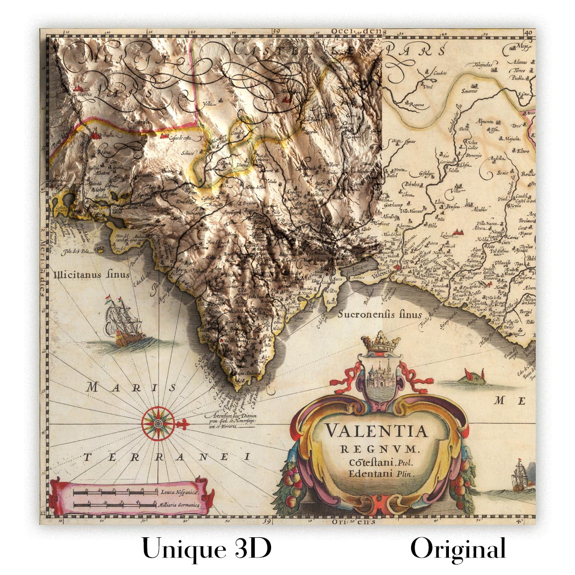
For something truly unique, this map is also available in "Unique 3D", our trademarked process that dramatically transforms the map so that it has a wonderful sense of depth. We combine the original map with detailed topography and elevation data, so that mountains and the terrain really "pop". For more info and examples of 3D maps, check my Unique 3D page.
Many of our maps and art prints are chosen as thoughtful gifts for homes, offices, studies and meaningful places.
Choose a framed option for the easiest ready-to-hang gift, or choose an unframed print if the recipient may prefer to select their own frame.
We make orders locally in 23 countries around the world, so gifts can often be produced close to the recipient. This helps them arrive faster, travel more safely, and avoid customs or import duty surprises.
- We can deliver directly to the recipient
- Framed pieces arrive ready to hang
- Unframed prints are carefully packed in a strong protective tube
- Almost every order is made locally, for faster, safer gifting
- 90-day returns give the recipient time to decide
If you are not sure what to choose, please contact us. We can help you pick the right map, size, finish or delivery option.
Most orders are made locally and delivered in around 2–3 working days, depending on the product, size and destination.
We print and frame maps and artwork in 23 countries around the world, so your order is usually made close to you or your recipient. That means faster delivery, less time in transit, and no customs or import duty surprises.
Personalised and customised pieces usually take an extra 1–2 working days, because we prepare your design and send it to you for approval before printing.
Very large framed orders can take a little longer, as they need extra care in production and delivery.
Every order is carefully packaged: unframed prints are sent in a strong protective tube, while framed pieces are securely packed with protective materials around the frame.
If you need your order by a particular date, please contact us before ordering. We’ll check the best production route and delivery option for your location.
Express delivery is available at checkout for most countries. Next-day delivery is available in the UK, US, Singapore and the UAE.
Your order is covered by our 90-day returns policy and 10-year guarantee.
Our standard frame is a gallery-style black ash hardwood frame, with a simple, modern look. It is approximately 20mm (0.8in) wide. You can also view some lovely customer photos of framed maps and art.
We use super-clear acrylic glazing, also known as Perspex or Acrylite, instead of traditional glass. It is lighter, safer, and has lower reflectivity, giving the artwork a clearer, cleaner appearance.
Six standard frame colours are available at no extra cost: black, dark brown, dark grey, oak, white, and antique gold. Custom framing and mounting/matting is also available for customers looking for something more specific.
Most maps, art prints, and illustrations are also available as a framed canvas. We use matte cotton canvas, stretch it over a sustainably sourced wooden box frame, and then float the piece within a wooden outer frame. The finished result is beautifully presented, with no glazing between you and the artwork.
All frames are supplied ready to hang, with either string or brackets fitted to the back. Very large frames will include heavy-duty hanging plates and/or a mounting baton. If you have any questions, please get in touch.
We can also supply old maps and artwork on canvas, foam board, cotton rag, and other materials.
If you would prefer to frame your map or artwork yourself, please read our size guide before ordering.
My maps are extremely high quality reproductions of original maps.
I source original, rare maps from libraries, auction houses and private collections around the world, restore them at my London workshop, and then use specialist giclée inks and printers to create beautiful maps that look even better than the original.
My maps are printed on acid-free archival matte (not glossy) paper that feels very high quality and almost like card. In technical terms the paper weight/thickness is 10mil/200gsm. It's perfect for framing.
I print with Epson ultrachrome giclée UV fade resistant pigment inks - some of the best inks you can find.
I can also make maps on canvas, cotton rag and other exotic materials.
Learn more about The Unique Maps Co.
Map personalisation
If you're looking for the perfect anniversary or housewarming gift, I can personalise your map to make it truly unique. For example, I can add a short message, or highlight an important location, or add your family's coat of arms.
The options are almost infinite. Please see my map personalisation page for some wonderful examples of what's possible.
To order a personalised map, select "personalise your map" before adding it to your basket.
Get in touch if you're looking for more complex customisations and personalisations.
Map ageing
I have been asked hundreds of times over the years by customers if they could buy a map that looks even older.
Well, now you can, by selecting Aged before you add a map to your basket.
All the product photos you see on this page show the map in its Original form. This is what the map looks like today.
If you select Aged, I will age your map by hand, using a special and unique process developed through years of studying old maps, talking to researchers to understand the chemistry of aging paper, and of course... lots of practice!
If you're unsure, stick to the Original colour of the map. If you want something a bit darker and older looking, go for Aged.
Se non sei soddisfatto del tuo ordine per qualsiasi motivo, contattami per un rimborso senza problemi. Si prega di consultare la nostra politica di reso e rimborso per ulteriori informazioni.
Sono molto sicuro che ti piacerà la tua mappa restaurata o la stampa d'arte. Lo faccio dal 1984. Sono un venditore Etsy a 5 stelle. Ho venduto decine di migliaia di mappe e stampe d'arte e ho oltre 5.000 recensioni reali a 5 stelle.
Utilizzo un processo unico per restaurare mappe e opere d'arte che richiede molto tempo e lavoro. Trovare le mappe e le illustrazioni originali può richiedere mesi. Utilizzo tecnologia all'avanguardia e incredibilmente costosa per scannerizzare e restaurarle. Di conseguenza, garantisco che le mie mappe e stampe d'arte siano superiori alle altre - ecco perché posso offrire un rimborso senza problemi.
Quasi tutte le mie mappe e stampe d'arte sembrano fantastiche a grandi dimensioni (200 cm, 6,5 piedi+) e posso anche incorniciarle e consegnarle a te, tramite un corriere speciale per oggetti di grandi dimensioni. Contattami per discutere delle tue esigenze specifiche.
Or try searching for something!


