


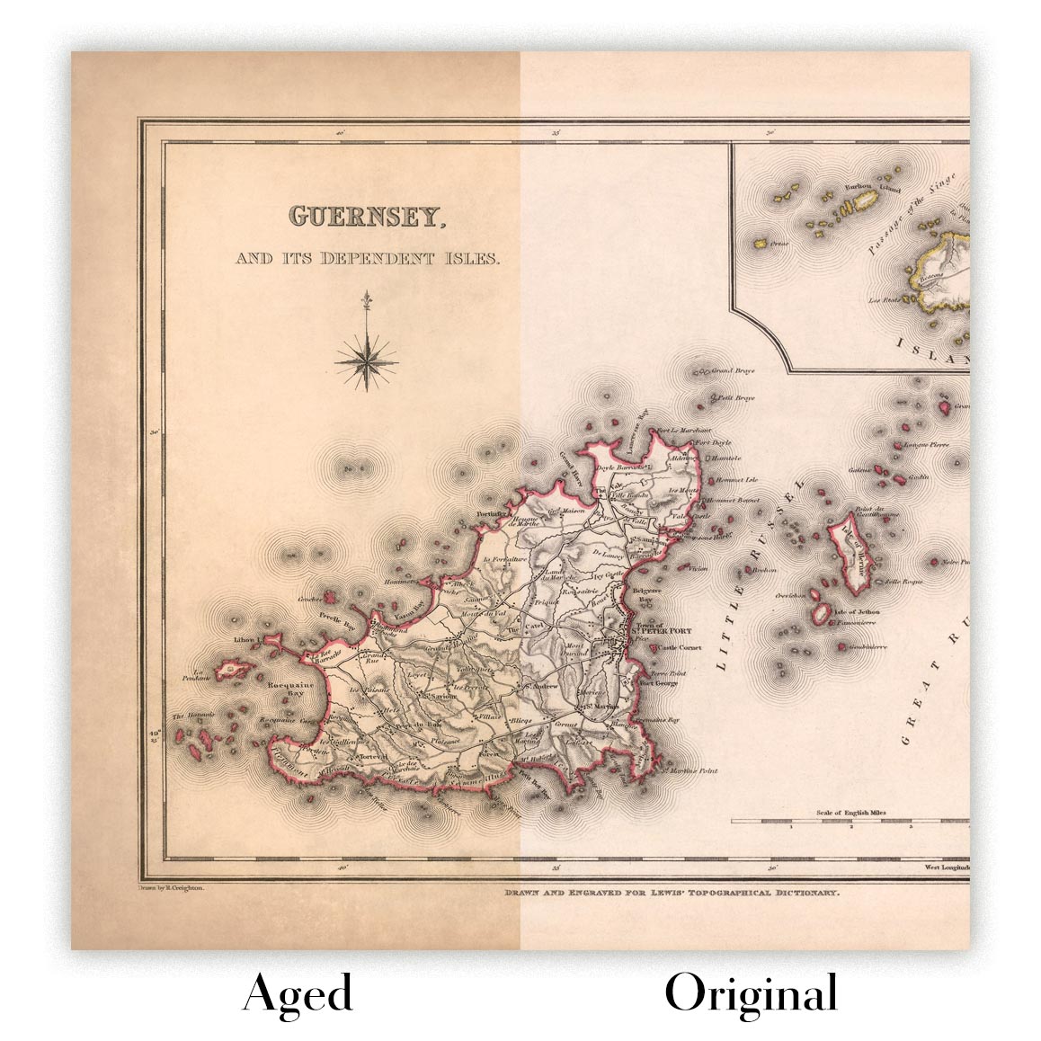


Mappa Antica di Durham di Samuel Lewis, 1844: Sunderland, Stockton-on-Tees, Hartlepool, Bishop Auckland, Darlington
L’offerta del Collezionista
Scegli due opere idonee e ricevi il 20% di sconto su entrambe. Scegline tre e quella al prezzo più basso è in omaggio, con un risparmio massimo del 33%.
Abbina liberamente mappe standard idonee e stampe d’arte fine art. Non è richiesto alcun codice; l’offerta viene applicata automaticamente al checkout.
Sono incluse le configurazioni standard su ordinazione. Sono esclusi formati su misura, design personalizzati e lavori su commissione.
Hai bisogno di consegne a indirizzi diversi? Contattaci prima di effettuare l’ordine.L’offerta del Collezionista
Scegli due opere idonee e ricevi il 20% di sconto su entrambe. Scegline tre e quella al prezzo più basso è in omaggio, con un risparmio massimo del 33%.
Abbina liberamente mappe standard idonee e stampe d’arte fine art. Non è richiesto alcun codice; l’offerta viene applicata automaticamente al checkout.
Sono incluse le configurazioni standard su ordinazione. Sono esclusi formati su misura, design personalizzati e lavori su commissione.
Hai bisogno di consegne a indirizzi diversi? Contattaci prima di effettuare l’ordine. Restaurato a Londra • Prodotto in Canada

Restaurata dalla mappa originale del 1844 e stampata in qualità museale. Leggi la storia dietro questa mappa
Choose your size
Choose your finish


(Maggiori informazioni)
Gift message & custom finish

If you want to add a gift message, or a finish (jigsaw, aluminium board, etc.) that is not available here, please request it in the "order note" when you check out.
Every order is custom made, so if you need the size adjusted slightly, or printed on an unusual material, just let us know. We've done thousands of custom orders over the years, so there's (almost) nothing we can't manage.
You can also contact us before you order, if you prefer!

- Prodotto localmente. Consegna sicura
- Nessun dazio o costo nascosto
- Serve aiuto? Chiamaci o messaggio su WhatsApp
Own a piece of history
8,000+ five-star reviews


Questa antica mappa della Contea di Durham, Inghilterra, realizzata da Samuel Lewis nel 1844, offre uno sguardo affascinante sul paesaggio storico della...
Continua a leggereQuesta antica mappa della Contea di Durham, Inghilterra, realizzata da Samuel Lewis nel 1844, offre uno sguardo affascinante sul paesaggio storico della regione. Con i suoi dettagli intricati e la squisita fattura, questa mappa è un autentico pezzo da collezione per gli appassionati di storia e gli amanti delle carte geografiche.
Uno degli aspetti più affascinanti di questa mappa è la rappresentazione delle principali città e centri dell’epoca. Pur non includendo Durham, la mappa mette in risalto altre località significative della contea. Sunderland, vivace città portuale nota per la sua industria cantieristica, è ben evidenziata. Stockton-on-Tees, con la sua ricca storia di città mercato e porto fluviale, è anch’essa in primo piano. La mappa cattura il patrimonio marittimo di Hartlepool, città costiera che ebbe un ruolo vitale nel commercio e nella difesa. Bishop Auckland, nota per il suo castello medievale e gli storici legami con i Vescovi di Durham, aggiunge un ulteriore livello di interesse. Infine, Darlington, città rinomata per il suo patrimonio ferroviario, completa l’elenco delle caratteristiche di rilievo di questa straordinaria mappa.
È importante notare che, sebbene alcune città moderne possano non essere presenti su questa mappa, essa offre una prospettiva unica sul passato della regione. In modo particolarmente interessante, alcuni insediamenti possono comparire con denominazioni più antiche, consentendoci di seguire l’evoluzione dei toponimi nel tempo. Questa mappa funge da capsula del tempo visiva, riportandoci alla metà del XIX secolo e offrendo preziose informazioni sulla geografia storica della Contea di Durham.
Insediamenti rilevanti fondati prima del 1840 entro i confini storici della Contea di Durham:
- Durham (995): La storica città capoluogo della contea e centro ecclesiastico, rinomata per la sua magnifica cattedrale e il suo castello.
- Sunderland (1179): Un’importante città portuale con una ricca tradizione marittima e una fiorente industria carbonifera.
- Stockton-on-Tees (1138): Una città mercato e porto fluviale, storicamente nota per il suo legame con la Stockton and Darlington Railway.
- Hartlepool (640): Una città costiera con una lunga storia di commerci marittimi e difesa, inclusi il celebre Headland e l’antica Abbazia.
- Darlington (1183): Una città rinomata per il suo patrimonio ferroviario, in quanto sede della prima stazione ferroviaria passeggeri del mondo.
- Bishop Auckland (1093): Una storica città mercato con legami con i Vescovi di Durham, che vanta l’imponente Auckland Castle.
- Chester-le-Street (883): Una città con una ricca storia che risale all’epoca romana, nota per il suo legame con il cricket e l’iconico Lumley Castle.
- Gateshead (XII secolo): Situata sulla riva meridionale del fiume Tyne, ha una lunga storia come importante punto di attraversamento e centro industriale.
- South Shields (1245): Una città costiera con una forte tradizione marittima, che vanta splendide spiagge e monumenti storici.
- Houghton-le-Spring (XII secolo): Una città con una ricca storia religiosa, sede della pittoresca Houghton Hall e del parco che la circonda.
- Washington (1096): Un antico insediamento con legami con gli antenati di George Washington, che presenta la splendida Washington Old Hall.
- Jarrow (681): Un’antica città nota per il suo legame con il Venerabile Beda e per il suo monastero medievale, la chiesa di St. Paul.
- Seaham (1828): Una città costiera con un’affascinante eredità industriale, inclusi i resti dell’un tempo fiorente Seaham Colliery.
- Peterlee (1948): Una new town istituita dopo la Seconda guerra mondiale, progettata per accogliere la crescente comunità mineraria.
- Consett (1840): una città emersa durante la Rivoluzione Industriale, rinomata per le sue acciaierie e ferriere.
Ulteriori insediamenti notevoli fondati prima del 1840 entro i confini storici della contea di Durham includono:
- Stanley (XII secolo): un'ex città mineraria del carbone con un ricco patrimonio industriale.
- Billingham (685): un antico insediamento con una storia di agricoltura e produzione chimica.
- Newton Aycliffe (1947): una new town creata dopo la Seconda guerra mondiale, originariamente progettata come centro industriale.
- Shildon (1823): una città strettamente associata alla nascita dell'industria ferroviaria, sede del National Railway Museum.
- Ferryhill (1840): una città sviluppatasi grazie all'espansione dell'industria mineraria del carbone nel XIX secolo.
- Spennymoor (1840): una città cresciuta rapidamente durante la Rivoluzione Industriale, alimentata dalle industrie del carbone e del ferro.
- Chester Moor (XII secolo): un villaggio con una lunga storia, situato vicino alle rive del fiume Wear.
- Sedgefield (XIII secolo): un'antica cittadina di mercato con un ricco patrimonio storico, compresi legami con la Magna Carta.
- Crook (1840): una città emersa durante la Rivoluzione Industriale, nota per le sue industrie del carbone e dei tessili.
- Brandon (XII secolo): un villaggio con una lunga storia, situato vicino al fiume Wear e alla città di Durham.
- Easington (XII secolo): una città costiera con una storia di estrazione del carbone e una splendida riserva naturale.
- Willington (1840): una città sviluppatasi grazie all'espansione dell'industria mineraria del carbone nel XIX secolo.
- Wingate (1840): un ex villaggio minerario cresciuto rapidamente durante la Rivoluzione Industriale.
- Murton (1840): una città emersa durante la Rivoluzione Industriale, trainata dall'industria mineraria del carbone.
- Trimdon (XII secolo): un villaggio con una lunga storia, associato alla nobile famiglia dei De Brus.
Confini, fiumi e attrazioni naturali notevoli nella contea di Durham, Inghilterra:
- River Tyne: un importante fiume che forma il confine tra la contea di Durham e il Tyne and Wear, noto per i suoi iconici ponti e il vivace lungofiume.
- River Wear: un fiume importante che attraversa Durham, Sunderland e altre città, con le sue pittoresche vallate e i suoi ponti storici.
- Durham Dales: una straordinaria area di altopiani che comprende il North Pennines Area of Outstanding Natural Beauty, offrendo paesaggi mozzafiato e villaggi incantevoli.
- Durham Heritage Coast: una splendida costa che si estende da Sunderland a Hartlepool, caratterizzata da spettacolari scogliere, spiagge sabbiose e habitat ricchi di fauna selvatica.
- Hamsterley Forest: una vasta area forestale nei Durham Dales, che offre opportunità per attività all'aperto come passeggiate, ciclismo e osservazione della fauna selvatica.
- High Force: una cascata mozzafiato sul fiume Tees, una delle meraviglie naturali più impressionanti dell'Inghilterra.
- Durham Cathedral and Castle: un sito Patrimonio dell'Umanità UNESCO, che ospita la magnifica Cattedrale di Durham e lo storico Castello di Durham.
Eventi storici notevoli nella contea di Durham tra il 1800 e il 1850:
- 1825: inaugurazione della Stockton and Darlington Railway, la prima ferrovia pubblica al mondo a utilizzare locomotive a vapore.
- 1832: il Reform Act del 1832, che ampliò il diritto di voto e riformò la rappresentanza parlamentare, ebbe un impatto sulla contea di Durham.
- 1838: la Durham Miners' Gala, un evento annuale iniziato come celebrazione del sindacalismo e dei diritti dei lavoratori, ebbe luogo a Durham City.
Si prega di notare che questo elenco non è esaustivo e che potrebbero esserci altri insediamenti, confini o eventi significativi rilevanti per la storia e la geografia della contea di Durham durante questo periodo.
Si prega di controllare attentamente le immagini per assicurarsi che una determinata città o località sia mostrata in questa mappa. Potete anche contattarci e chiederci di verificare la mappa per voi.
Questa mappa ha un aspetto eccellente in tutte le dimensioni: 12x16in (30,5x41cm), 16x20in (40,5x51cm), 18x24in (45,5x61cm), 24x30in (61x76cm), 32x40in (81,5x102cm) e 40x50in (102x127cm), ma rende ancora meglio se stampata in grande formato.
Posso realizzare splendide stampe di grandi dimensioni di questa mappa fino a 50in (127cm). Si prega di contattarmi se cercate opzioni di incorniciatura più grandi, personalizzate o diverse.
Il modello nelle immagini dell'inserzione tiene in mano la versione 16x20in (40,5x51cm) di questa mappa.
La quinta immagine dell'inserzione mostra un esempio del mio servizio di personalizzazione delle mappe.
Se cercate qualcosa di leggermente diverso, date un'occhiata alla mia collezione principale di mappe del Regno Unito e dell'Irlanda.
Vi prego di contattarmi per verificare se una certa località, punto di riferimento o caratteristica è mostrata in questa mappa.
Sarebbe un meraviglioso regalo di compleanno, Natale, Festa del Papà, per un collega che lascia il lavoro, anniversario o inaugurazione della casa per qualcuno delle aree coperte da questa mappa.
Questa mappa è disponibile come stampa giclée su carta opaca d'archivio priva di acidi, oppure potete acquistarla incorniciata. La cornice è una bella e semplice cornice nera che si adatta alla maggior parte degli stili. Vi prego di contattarmi se desiderate un colore o un materiale della cornice diverso. Le mie cornici sono protette da vetro in acrilico di grado museale supertrasparente (perspex/acrylite), che è notevolmente meno riflettente del vetro, più sicuro e arriverà sempre in perfette condizioni.
This map is also available as a float framed canvas, sometimes known as a shadow gap framed canvas or canvas floater. The map is printed on artist's cotton canvas and then stretched over a handmade box frame. We then "float" the canvas inside a wooden frame, which is available in a range of colours (black, dark brown, oak, antique gold and white). This is a wonderful way to present a map without glazing in front. See some examples of float framed canvas maps and explore the differences between my different finishes.
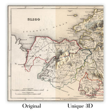
For something truly unique, this map is also available in "Unique 3D", our trademarked process that dramatically transforms the map so that it has a wonderful sense of depth. We combine the original map with detailed topography and elevation data, so that mountains and the terrain really "pop". For more info and examples of 3D maps, check my Unique 3D page.
Questa antica mappa della Contea di Durham, Inghilterra, realizzata da Samuel Lewis nel 1844, offre uno sguardo affascinante sul paesaggio storico della regione. Con i suoi dettagli intricati e la squisita fattura, questa mappa è un autentico pezzo da collezione per gli appassionati di storia e gli amanti delle carte geografiche.
Uno degli aspetti più affascinanti di questa mappa è la rappresentazione delle principali città e centri dell’epoca. Pur non includendo Durham, la mappa mette in risalto altre località significative della contea. Sunderland, vivace città portuale nota per la sua industria cantieristica, è ben evidenziata. Stockton-on-Tees, con la sua ricca storia di città mercato e porto fluviale, è anch’essa in primo piano. La mappa cattura il patrimonio marittimo di Hartlepool, città costiera che ebbe un ruolo vitale nel commercio e nella difesa. Bishop Auckland, nota per il suo castello medievale e gli storici legami con i Vescovi di Durham, aggiunge un ulteriore livello di interesse. Infine, Darlington, città rinomata per il suo patrimonio ferroviario, completa l’elenco delle caratteristiche di rilievo di questa straordinaria mappa.
È importante notare che, sebbene alcune città moderne possano non essere presenti su questa mappa, essa offre una prospettiva unica sul passato della regione. In modo particolarmente interessante, alcuni insediamenti possono comparire con denominazioni più antiche, consentendoci di seguire l’evoluzione dei toponimi nel tempo. Questa mappa funge da capsula del tempo visiva, riportandoci alla metà del XIX secolo e offrendo preziose informazioni sulla geografia storica della Contea di Durham.
Insediamenti rilevanti fondati prima del 1840 entro i confini storici della Contea di Durham:
- Durham (995): La storica città capoluogo della contea e centro ecclesiastico, rinomata per la sua magnifica cattedrale e il suo castello.
- Sunderland (1179): Un’importante città portuale con una ricca tradizione marittima e una fiorente industria carbonifera.
- Stockton-on-Tees (1138): Una città mercato e porto fluviale, storicamente nota per il suo legame con la Stockton and Darlington Railway.
- Hartlepool (640): Una città costiera con una lunga storia di commerci marittimi e difesa, inclusi il celebre Headland e l’antica Abbazia.
- Darlington (1183): Una città rinomata per il suo patrimonio ferroviario, in quanto sede della prima stazione ferroviaria passeggeri del mondo.
- Bishop Auckland (1093): Una storica città mercato con legami con i Vescovi di Durham, che vanta l’imponente Auckland Castle.
- Chester-le-Street (883): Una città con una ricca storia che risale all’epoca romana, nota per il suo legame con il cricket e l’iconico Lumley Castle.
- Gateshead (XII secolo): Situata sulla riva meridionale del fiume Tyne, ha una lunga storia come importante punto di attraversamento e centro industriale.
- South Shields (1245): Una città costiera con una forte tradizione marittima, che vanta splendide spiagge e monumenti storici.
- Houghton-le-Spring (XII secolo): Una città con una ricca storia religiosa, sede della pittoresca Houghton Hall e del parco che la circonda.
- Washington (1096): Un antico insediamento con legami con gli antenati di George Washington, che presenta la splendida Washington Old Hall.
- Jarrow (681): Un’antica città nota per il suo legame con il Venerabile Beda e per il suo monastero medievale, la chiesa di St. Paul.
- Seaham (1828): Una città costiera con un’affascinante eredità industriale, inclusi i resti dell’un tempo fiorente Seaham Colliery.
- Peterlee (1948): Una new town istituita dopo la Seconda guerra mondiale, progettata per accogliere la crescente comunità mineraria.
- Consett (1840): una città emersa durante la Rivoluzione Industriale, rinomata per le sue acciaierie e ferriere.
Ulteriori insediamenti notevoli fondati prima del 1840 entro i confini storici della contea di Durham includono:
- Stanley (XII secolo): un'ex città mineraria del carbone con un ricco patrimonio industriale.
- Billingham (685): un antico insediamento con una storia di agricoltura e produzione chimica.
- Newton Aycliffe (1947): una new town creata dopo la Seconda guerra mondiale, originariamente progettata come centro industriale.
- Shildon (1823): una città strettamente associata alla nascita dell'industria ferroviaria, sede del National Railway Museum.
- Ferryhill (1840): una città sviluppatasi grazie all'espansione dell'industria mineraria del carbone nel XIX secolo.
- Spennymoor (1840): una città cresciuta rapidamente durante la Rivoluzione Industriale, alimentata dalle industrie del carbone e del ferro.
- Chester Moor (XII secolo): un villaggio con una lunga storia, situato vicino alle rive del fiume Wear.
- Sedgefield (XIII secolo): un'antica cittadina di mercato con un ricco patrimonio storico, compresi legami con la Magna Carta.
- Crook (1840): una città emersa durante la Rivoluzione Industriale, nota per le sue industrie del carbone e dei tessili.
- Brandon (XII secolo): un villaggio con una lunga storia, situato vicino al fiume Wear e alla città di Durham.
- Easington (XII secolo): una città costiera con una storia di estrazione del carbone e una splendida riserva naturale.
- Willington (1840): una città sviluppatasi grazie all'espansione dell'industria mineraria del carbone nel XIX secolo.
- Wingate (1840): un ex villaggio minerario cresciuto rapidamente durante la Rivoluzione Industriale.
- Murton (1840): una città emersa durante la Rivoluzione Industriale, trainata dall'industria mineraria del carbone.
- Trimdon (XII secolo): un villaggio con una lunga storia, associato alla nobile famiglia dei De Brus.
Confini, fiumi e attrazioni naturali notevoli nella contea di Durham, Inghilterra:
- River Tyne: un importante fiume che forma il confine tra la contea di Durham e il Tyne and Wear, noto per i suoi iconici ponti e il vivace lungofiume.
- River Wear: un fiume importante che attraversa Durham, Sunderland e altre città, con le sue pittoresche vallate e i suoi ponti storici.
- Durham Dales: una straordinaria area di altopiani che comprende il North Pennines Area of Outstanding Natural Beauty, offrendo paesaggi mozzafiato e villaggi incantevoli.
- Durham Heritage Coast: una splendida costa che si estende da Sunderland a Hartlepool, caratterizzata da spettacolari scogliere, spiagge sabbiose e habitat ricchi di fauna selvatica.
- Hamsterley Forest: una vasta area forestale nei Durham Dales, che offre opportunità per attività all'aperto come passeggiate, ciclismo e osservazione della fauna selvatica.
- High Force: una cascata mozzafiato sul fiume Tees, una delle meraviglie naturali più impressionanti dell'Inghilterra.
- Durham Cathedral and Castle: un sito Patrimonio dell'Umanità UNESCO, che ospita la magnifica Cattedrale di Durham e lo storico Castello di Durham.
Eventi storici notevoli nella contea di Durham tra il 1800 e il 1850:
- 1825: inaugurazione della Stockton and Darlington Railway, la prima ferrovia pubblica al mondo a utilizzare locomotive a vapore.
- 1832: il Reform Act del 1832, che ampliò il diritto di voto e riformò la rappresentanza parlamentare, ebbe un impatto sulla contea di Durham.
- 1838: la Durham Miners' Gala, un evento annuale iniziato come celebrazione del sindacalismo e dei diritti dei lavoratori, ebbe luogo a Durham City.
Si prega di notare che questo elenco non è esaustivo e che potrebbero esserci altri insediamenti, confini o eventi significativi rilevanti per la storia e la geografia della contea di Durham durante questo periodo.
Si prega di controllare attentamente le immagini per assicurarsi che una determinata città o località sia mostrata in questa mappa. Potete anche contattarci e chiederci di verificare la mappa per voi.
Questa mappa ha un aspetto eccellente in tutte le dimensioni: 12x16in (30,5x41cm), 16x20in (40,5x51cm), 18x24in (45,5x61cm), 24x30in (61x76cm), 32x40in (81,5x102cm) e 40x50in (102x127cm), ma rende ancora meglio se stampata in grande formato.
Posso realizzare splendide stampe di grandi dimensioni di questa mappa fino a 50in (127cm). Si prega di contattarmi se cercate opzioni di incorniciatura più grandi, personalizzate o diverse.
Il modello nelle immagini dell'inserzione tiene in mano la versione 16x20in (40,5x51cm) di questa mappa.
La quinta immagine dell'inserzione mostra un esempio del mio servizio di personalizzazione delle mappe.
Se cercate qualcosa di leggermente diverso, date un'occhiata alla mia collezione principale di mappe del Regno Unito e dell'Irlanda.
Vi prego di contattarmi per verificare se una certa località, punto di riferimento o caratteristica è mostrata in questa mappa.
Sarebbe un meraviglioso regalo di compleanno, Natale, Festa del Papà, per un collega che lascia il lavoro, anniversario o inaugurazione della casa per qualcuno delle aree coperte da questa mappa.
Questa mappa è disponibile come stampa giclée su carta opaca d'archivio priva di acidi, oppure potete acquistarla incorniciata. La cornice è una bella e semplice cornice nera che si adatta alla maggior parte degli stili. Vi prego di contattarmi se desiderate un colore o un materiale della cornice diverso. Le mie cornici sono protette da vetro in acrilico di grado museale supertrasparente (perspex/acrylite), che è notevolmente meno riflettente del vetro, più sicuro e arriverà sempre in perfette condizioni.
This map is also available as a float framed canvas, sometimes known as a shadow gap framed canvas or canvas floater. The map is printed on artist's cotton canvas and then stretched over a handmade box frame. We then "float" the canvas inside a wooden frame, which is available in a range of colours (black, dark brown, oak, antique gold and white). This is a wonderful way to present a map without glazing in front. See some examples of float framed canvas maps and explore the differences between my different finishes.
For something truly unique, this map is also available in "Unique 3D", our trademarked process that dramatically transforms the map so that it has a wonderful sense of depth. We combine the original map with detailed topography and elevation data, so that mountains and the terrain really "pop". For more info and examples of 3D maps, check my Unique 3D page.
Many of our maps and art prints are chosen as thoughtful gifts for homes, offices, studies and meaningful places.
Choose a framed option for the easiest ready-to-hang gift, or choose an unframed print if the recipient may prefer to select their own frame.
We make orders locally in 23 countries around the world, so gifts can often be produced close to the recipient. This helps them arrive faster, travel more safely, and avoid customs or import duty surprises.
- We can deliver directly to the recipient
- Framed pieces arrive ready to hang
- Unframed prints are carefully packed in a strong protective tube
- Almost every order is made locally, for faster, safer gifting
- 90-day returns give the recipient time to decide
If you are not sure what to choose, please contact us. We can help you pick the right map, size, finish or delivery option.
Most orders are made locally and delivered in around 2–3 working days, depending on the product, size and destination.
We print and frame maps and artwork in 23 countries around the world, so your order is usually made close to you or your recipient. That means faster delivery, less time in transit, and no customs or import duty surprises.
Personalised and customised pieces usually take an extra 1–2 working days, because we prepare your design and send it to you for approval before printing.
Very large framed orders can take a little longer, as they need extra care in production and delivery.
Every order is carefully packaged: unframed prints are sent in a strong protective tube, while framed pieces are securely packed with protective materials around the frame.
If you need your order by a particular date, please contact us before ordering. We’ll check the best production route and delivery option for your location.
Express delivery is available at checkout for most countries. Next-day delivery is available in the UK, US, Singapore and the UAE.
Your order is covered by our 90-day returns policy and 10-year guarantee.
Our standard frame is a gallery-style black ash hardwood frame, with a simple, modern look. It is approximately 20mm (0.8in) wide. You can also view some lovely customer photos of framed maps and art.
We use super-clear acrylic glazing, also known as Perspex or Acrylite, instead of traditional glass. It is lighter, safer, and has lower reflectivity, giving the artwork a clearer, cleaner appearance.
Six standard frame colours are available at no extra cost: black, dark brown, dark grey, oak, white, and antique gold. Custom framing and mounting/matting is also available for customers looking for something more specific.
Most maps, art prints, and illustrations are also available as a framed canvas. We use matte cotton canvas, stretch it over a sustainably sourced wooden box frame, and then float the piece within a wooden outer frame. The finished result is beautifully presented, with no glazing between you and the artwork.
All frames are supplied ready to hang, with either string or brackets fitted to the back. Very large frames will include heavy-duty hanging plates and/or a mounting baton. If you have any questions, please get in touch.
We can also supply old maps and artwork on canvas, foam board, cotton rag, and other materials.
If you would prefer to frame your map or artwork yourself, please read our size guide before ordering.
Every Unique Maps piece begins with an authentic cartographic source or an original design from our London studio.
For our historic maps, we source rare originals from libraries, archives, auction houses and private collections around the world. We carefully restore each map for print—repairing age-related damage, balancing colour and improving clarity while preserving its original detail, texture and character.
Once restored, the map is prepared for your chosen size and finish. Your piece is then printed and, where selected, framed close to its delivery destination.
Our map prints use acid-free 200gsm archival matte paper and fade-resistant pigment inks, creating a rich, non-glossy finish designed to last. Framed maps use crystal-clear optical acrylic and arrive ready to hang.
Canvas, cotton-rag and other specialist presentations are also available. Learn more about our materials and finishes.
Personalising your map
You can add a short title or dedication, mark one meaningful place, or request one considered visual detail. For personalised designs, we send a proof before printing and you can request changes before approval.
For more complex bespoke commissions, contact our design team.
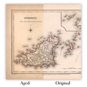
Original or Aged
Choose Original for true-to-source colour, or Aged for a warmer, richer antique character created with our specialist ageing process. See examples of our Aged maps.
Se non sei soddisfatto del tuo ordine per qualsiasi motivo, contattami per un rimborso senza problemi. Si prega di consultare la nostra politica di reso e rimborso per ulteriori informazioni.
Sono molto sicuro che ti piacerà la tua mappa restaurata o la stampa d'arte. Lo faccio dal 1984. Sono un venditore Etsy a 5 stelle. Ho venduto decine di migliaia di mappe e stampe d'arte e ho oltre 5.000 recensioni reali a 5 stelle.
Utilizzo un processo unico per restaurare mappe e opere d'arte che richiede molto tempo e lavoro. Trovare le mappe e le illustrazioni originali può richiedere mesi. Utilizzo tecnologia all'avanguardia e incredibilmente costosa per scannerizzare e restaurarle. Di conseguenza, garantisco che le mie mappe e stampe d'arte siano superiori alle altre - ecco perché posso offrire un rimborso senza problemi.
Quasi tutte le mie mappe e stampe d'arte sembrano fantastiche a grandi dimensioni (200 cm, 6,5 piedi+) e posso anche incorniciarle e consegnarle a te, tramite un corriere speciale per oggetti di grandi dimensioni. Contattami per discutere delle tue esigenze specifiche.
Or try searching for something!


