


Mappa Antica della Battaglia di Long Island, 1776: Rivoluzione Americana, Sbarco Britannico
20% di sconto su 2 — 33% di sconto su 3
Aggiungi qualsiasi due articoli idonei al tuo carrello per ricevere 20% di sconto. Aggiungi un terzo e sarà gratuito (equivalente a 33% di sconto quando acquisti tre).
Nessun codice necessario — l'offerta si applica automaticamente al checkout.
Valido su tutte le mappe standard e le stampe d'arte fine. Puoi mescolare e abbinare qualsiasi design.
Se desideri spedire articoli a più indirizzi, ti preghiamo di contattarci prima di effettuare il tuo ordine.
Le commissioni personalizzate e su misura sono escluse.
Contattaci se hai domande
 Progettato a Londra Prodotto in Canada
Progettato a Londra • Prodotto in Canada
Progettato a Londra Prodotto in Canada
Progettato a Londra • Prodotto in Canada

Choose your size
Choose your finish


(Maggiori informazioni)
Gift message & custom finish

If you want to add a gift message, or a finish (jigsaw, aluminium board, etc.) that is not available here, please request it in the "order note" when you check out.
Every order is custom made, so if you need the size adjusted slightly, or printed on an unusual material, just let us know. We've done thousands of custom orders over the years, so there's (almost) nothing we can't manage.
You can also contact us before you order, if you prefer!

- Made locally for fast, safe delivery
- No import duty or hidden fees
- Need advice? Message us on WhatsApp
Own a piece of history
7,000+ 5 star reviews


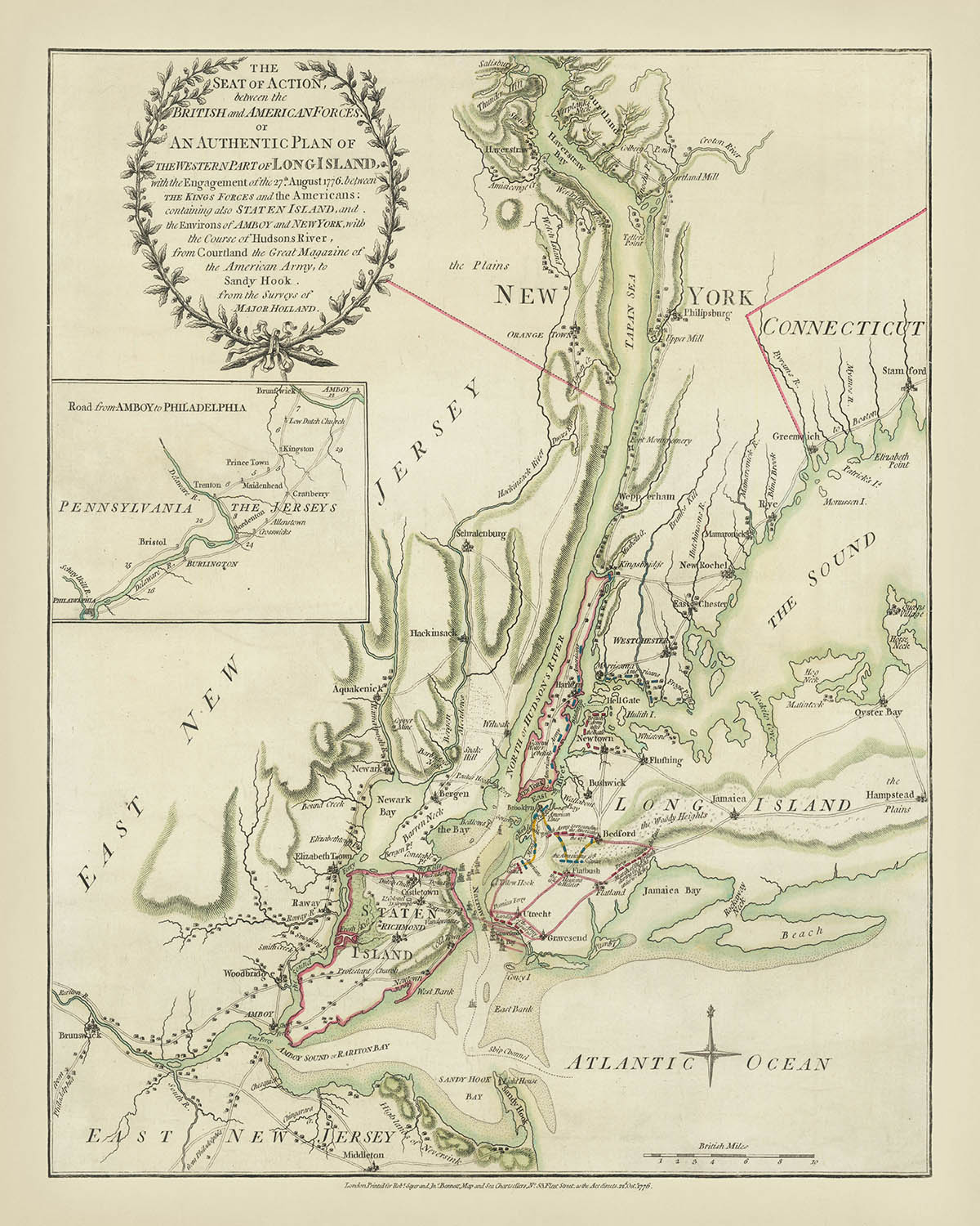
Entra nella ricca storia della Rivoluzione Americana con questa squisita mappa del 1776, "Il Teatro d'Azione tra le Forze Britanniche e Americane." Creata dai rinomati cartografi Sayer & Bennett, questo capolavoro cartografico dettagliato cattura una delle battaglie iniziali fondamentali della guerra—la Battaglia di Long Island. La mappa illustra vividamente le manovre strategiche e gli scontri militari tra le forze britanniche e americane, offrendo uno sguardo affascinante sulle complessità tattiche dell'epoca.
La mappa non è solo una rappresentazione geografica ma un'infografica dinamica che trasmette il dramma in evoluzione della battaglia. Traccia meticolosamente lo sbarco britannico a Gravesend Bay, le linee difensive americane lungo Gowanus Heights e la cruciale manovra di fiancheggiamento attraverso Jamaica Pass. La narrazione visiva è arricchita da annotazioni e simboli che evidenziano le posizioni militari chiave, i movimenti delle truppe e il successivo ritiro americano a Brooklyn. Questo livello di dettaglio offre un'illuminante visione del pensiero strategico e delle sfide affrontate da entrambe le parti.
Aggiungendo alla sua importanza storica, la mappa si basa sui rilievi del Maggiore Samuel Holland, una figura prominente nella cartografia del XVIII secolo. L'esperienza di Holland ha garantito l'accuratezza e il dettaglio della mappa, rendendola una risorsa inestimabile per comprendere gli elementi geografici e tattici della battaglia. La pubblicazione di questa mappa da parte di Sayer & Bennett poco dopo la battaglia sottolinea la sua importanza come documento contemporaneo di un momento critico nella Guerra Rivoluzionaria.
La mappa funge anche da ricco deposito di informazioni geografiche, estendendosi da Courtland sul fiume Hudson a Sandy Hook e Middletown nel New Jersey. Presenta città, insediamenti, strade e dettagli topografici, fornendo una visione completa della regione durante la fine del XVIII secolo. L'inclusione della flotta britannica nella Baia di New York e delle fortificazioni americane a Long Island e Manhattan arricchisce ulteriormente la narrazione della mappa, offrendo una visione olistica degli aspetti militari e navali del conflitto.
Questa mappa è una testimonianza dell'arte e della precisione della cartografia del XVIII secolo, fondendo narrazione storica con dettagli geografici. Rappresenta un artefatto prezioso per storici, collezionisti e chiunque abbia una passione per la Rivoluzione Americana. Il design intricato della mappa e il contesto storico la rendono un'aggiunta affascinante a qualsiasi collezione, offrendo una finestra sul paesaggio strategico e geografico di uno dei conflitti più definitivi dell'America.
Luoghi su questa mappa
- Città di New York
- Long Island
- Staten Island
- New Jersey
- Connecticut
- Fiume Hudson
- East River
- The Sound
- Oceano Atlantico
- Gravesend Bay
- Gowanus Heights
- Brooklyn
- Manhattan
- Sandy Hook
- Middletown
- Courtland
- Amboy
- Filadelfia
- Newark Bay
- Hackinsack
- New Rochelle
- Stamford
- Hempstead Plains
- Jamaica Pass
- Greenwich
- White Plains
- Baia di Tappan
- Haverstraw
- Poughkeepsie
- Esopus
Caratteristiche e Monumenti Notabili
- Sito di sbarco britannico: Baia di Gravesend nell'est di Long Island.
- Linee difensive americane: Si estendono dalla costa verso est lungo Gowanus Heights.
- Movimenti delle truppe britanniche: Due colonne che attaccano le forze americane e l'attacco principale attraverso Jamaica Pass.
- Ritiro americano: Verso le fortificazioni nel villaggio di Brooklyn sul fiume East.
- Flotta britannica assemblata: Nella baia di New York.
- Caratteristiche geografiche: Città principali, insediamenti, strade e residenze.
- Mappa in evidenza: Mostra la strada da Amboy a Philadelphia.
- Dettagli topografici: Inclusi fiumi, baie e colline.
- Posizioni militari: Sia le posizioni britanniche che americane sono contrassegnate.
- Luoghi chiave: Come Manhattan, Long Island, Staten Island e parti del New Jersey.
- Corpi idrici: Fiume Hudson, East River, The Sound e Oceano Atlantico.
- Contesto storico: La mappa è stata pubblicata poco dopo la battaglia, riflettendo le conseguenze immediate e i movimenti strategici.
- Dettagli cartografici: Basati sui sondaggi del Maggiore Holland, fornendo accuratezza e dettaglio.
- Legenda della mappa: Spiegando simboli e contrassegni utilizzati sulla mappa.
- Rosone della bussola: Indica le direzioni sulla mappa.
- Barra di scala: Per misurare le distanze sulla mappa.
- Annotazioni: Descrivono eventi e movimenti chiave durante la battaglia.
- Narrativa storica: La mappa racconta la storia della Battaglia di Long Island attraverso la rappresentazione visiva.
- Strategia britannica: Illustra attraverso la rappresentazione dei movimenti delle truppe e degli sbarchi.
- Fortificazioni americane: Mostrate a Brooklyn e in altri punti strategici.
- Presenza navale: Rappresenta il posizionamento strategico della flotta britannica.
- Confini geopolitici: Indica i confini di New York, New Jersey e Connecticut.
- Monumenti storici: Siti importanti legati alla battaglia e alla Guerra di Indipendenza.
- Stile visivo: Riflette le convenzioni artistiche e cartografiche della fine del XVIII secolo.
Contesto storico e di design
- Nome della mappa: Il Luogo dell'Azione tra le Forze Britanniche e Americane. O un Piano Autentico della Parte Occidentale di Long Island, con l'ingaggio del 27 agosto 1776 tra le Forze del Re e gli Americani . . . dai Sondaggi del Maggiore Holland.
- Data di creazione: 1776
- Cartografo o editore: Sayer & Bennett
- Contesto interessante sul cartografo: Sayer & Bennett erano editori di mappe prominenti nel XVIII secolo, noti per la produzione di mappe dettagliate e accurate. Pubblicarono questa mappa poco dopo la Battaglia di Long Island, e probabilmente competette con la mappa dello stesso evento di William Faden.
- Significato storico:
- Battaglia di Long Island: La mappa rappresenta la Battaglia di Long Island, una delle prime e significative battaglie della Rivoluzione Americana.
- Strategia britannica: La mappa illustra la strategia britannica per isolare il New England e ottenere il controllo del basso Hudson, mirando a isolare e sopraffare le colonie settentrionali.
- Ritirata americana: Documenta la ritirata delle forze americane verso Brooklyn e la loro successiva evacuazione a Manhattan, un momento critico nella battaglia.
- Argomenti e temi mostrati sulla mappa:
- Posizioni e movimenti militari: La mappa mostra lo sbarco britannico, i movimenti delle truppe e le posizioni difensive americane.
- Caratteristiche geografiche: Include città, insediamenti, principali caratteristiche topografiche, strade e abitazioni.
- Presenza navale: La flotta britannica assemblata nella baia di New York è rappresentata.
- Paesi e regioni mostrati sulla mappa:
- Stati Uniti: La mappa si concentra sull'area intorno a New York City, comprese parti del New Jersey, Long Island e Connecticut.
- Design o stile della mappa:
- Mappa tematica infografica: Trasmette informazioni dettagliate sulla battaglia e sui movimenti delle truppe in modo illustrativo.
- Cartografia storica: La mappa è stata basata su rilievi del Maggiore Holland e riflette lo stile cartografico della fine del XVIII secolo.
- Contesto aggiuntivo:
- Evacuazione britannica di Boston: La mappa segue la ritirata britannica da Boston e la loro successiva strategia per controllare New York.
- Importanza strategica di New York: La mappa evidenzia l'importanza di New York nel piano britannico per dominare le colonie settentrionali.
Si prega di controllare attentamente le immagini per assicurarsi che una specifica città o luogo sia mostrato su questa mappa. Puoi anche contattarci e chiedere di controllare la mappa per te.
Questa mappa appare ottima in ogni dimensione, ma consiglio sempre di optare per una dimensione più grande se hai spazio. In questo modo puoi facilmente distinguere tutti i dettagli.
Questa mappa appare fantastica in dimensioni fino a 70 pollici (180 cm). Se stai cercando una mappa più grande, per favore contattaci.
Si prega di notare: le etichette su questa mappa sono difficili da leggere se ordini una mappa che è 20 pollici (50 cm) o più piccola. La mappa è comunque molto attraente, ma se desideri leggere facilmente la mappa, ti preghiamo di acquistare una dimensione più grande.
Il modello nelle immagini dell'inserzione tiene la versione 16x20 pollici (40x50 cm) di questa mappa.
La quinta immagine dell'inserzione mostra un esempio del mio servizio di personalizzazione della mappa.
Se stai cercando qualcosa di leggermente diverso, dai un'occhiata alla mia collezione delle migliori vecchie mappe per vedere se qualcosa attira la tua attenzione.
Per favore contattami per controllare se un certo luogo, punto di riferimento o caratteristica è mostrato su questa mappa.
Questo sarebbe un regalo meraviglioso per un compleanno, Natale, Festa del Papà, partenza dal lavoro, anniversario o inaugurazione della casa per qualcuno delle aree coperte da questa mappa.
Questa mappa è disponibile come stampa giclée su carta opaca archiviabile senza acidi, oppure puoi acquistarla incorniciata. La cornice è una bella e semplice cornice nera che si adatta alla maggior parte degli stili. Ti preghiamo di contattarci se desideri un colore o un materiale diverso per la cornice. Le mie cornici sono dotate di un vetro acrilico super chiaro di qualità museale (perspex/acrylite), che è significativamente meno riflettente del vetro, più sicuro e arriverà sempre in perfette condizioni.
This map is also available as a float framed canvas, sometimes known as a shadow gap framed canvas or canvas floater. The map is printed on artist's cotton canvas and then stretched over a handmade box frame. We then "float" the canvas inside a wooden frame, which is available in a range of colours (black, dark brown, oak, antique gold and white). This is a wonderful way to present a map without glazing in front. See some examples of float framed canvas maps and explore the differences between my different finishes.
For something truly unique, this map is also available in "Unique 3D", our trademarked process that dramatically transforms the map so that it has a wonderful sense of depth. We combine the original map with detailed topography and elevation data, so that mountains and the terrain really "pop". For more info and examples of 3D maps, check my Unique 3D page.
Many of our maps and art prints are chosen as thoughtful gifts for homes, offices, studies and meaningful places.
Choose a framed option for the easiest ready-to-hang gift, or choose an unframed print if the recipient may prefer to select their own frame.
We make orders locally in 23 countries around the world, so gifts can often be produced close to the recipient. This helps them arrive faster, travel more safely, and avoid customs or import duty surprises.
- We can deliver directly to the recipient
- Framed pieces arrive ready to hang
- Unframed prints are carefully packed in a strong protective tube
- Almost every order is made locally, for faster, safer gifting
- 90-day returns give the recipient time to decide
If you are not sure what to choose, please contact us. We can help you pick the right map, size, finish or delivery option.
Most orders are made locally and delivered in around 2–3 working days, depending on the product, size and destination.
We print and frame maps and artwork in 23 countries around the world, so your order is usually made close to you or your recipient. That means faster delivery, less time in transit, and no customs or import duty surprises.
Personalised and customised pieces usually take an extra 1–2 working days, because we prepare your design and send it to you for approval before printing.
Very large framed orders can take a little longer, as they need extra care in production and delivery.
Every order is carefully packaged: unframed prints are sent in a strong protective tube, while framed pieces are securely packed with protective materials around the frame.
If you need your order by a particular date, please contact us before ordering. We’ll check the best production route and delivery option for your location.
Express delivery is available at checkout for most countries. Next-day delivery is available in the UK, US, Singapore and the UAE.
Your order is covered by our 90-day returns policy and 10-year guarantee.
Our standard frame is a gallery-style black ash hardwood frame, with a simple, modern look. It is approximately 20mm (0.8in) wide. You can also view some lovely customer photos of framed maps and art.
We use super-clear acrylic glazing, also known as Perspex or Acrylite, instead of traditional glass. It is lighter, safer, and has lower reflectivity, giving the artwork a clearer, cleaner appearance.
Six standard frame colours are available at no extra cost: black, dark brown, dark grey, oak, white, and antique gold. Custom framing and mounting/matting is also available for customers looking for something more specific.
Most maps, art prints, and illustrations are also available as a framed canvas. We use matte cotton canvas, stretch it over a sustainably sourced wooden box frame, and then float the piece within a wooden outer frame. The finished result is beautifully presented, with no glazing between you and the artwork.
All frames are supplied ready to hang, with either string or brackets fitted to the back. Very large frames will include heavy-duty hanging plates and/or a mounting baton. If you have any questions, please get in touch.
We can also supply old maps and artwork on canvas, foam board, cotton rag, and other materials.
If you would prefer to frame your map or artwork yourself, please read our size guide before ordering.
My maps are extremely high quality reproductions of original maps.
I source original, rare maps from libraries, auction houses and private collections around the world, restore them at my London workshop, and then use specialist giclée inks and printers to create beautiful maps that look even better than the original.
My maps are printed on acid-free archival matte (not glossy) paper that feels very high quality and almost like card. In technical terms the paper weight/thickness is 10mil/200gsm. It's perfect for framing.
I print with Epson ultrachrome giclée UV fade resistant pigment inks - some of the best inks you can find.
I can also make maps on canvas, cotton rag and other exotic materials.
Learn more about The Unique Maps Co.
Map personalisation
If you're looking for the perfect anniversary or housewarming gift, I can personalise your map to make it truly unique. For example, I can add a short message, or highlight an important location, or add your family's coat of arms.
The options are almost infinite. Please see my map personalisation page for some wonderful examples of what's possible.
To order a personalised map, select "personalise your map" before adding it to your basket.
Get in touch if you're looking for more complex customisations and personalisations.
Map ageing
I have been asked hundreds of times over the years by customers if they could buy a map that looks even older.
Well, now you can, by selecting Aged before you add a map to your basket.
All the product photos you see on this page show the map in its Original form. This is what the map looks like today.
If you select Aged, I will age your map by hand, using a special and unique process developed through years of studying old maps, talking to researchers to understand the chemistry of aging paper, and of course... lots of practice!
If you're unsure, stick to the Original colour of the map. If you want something a bit darker and older looking, go for Aged.
Se non sei soddisfatto del tuo ordine per qualsiasi motivo, contattami per un rimborso senza problemi. Si prega di consultare la nostra politica di reso e rimborso per ulteriori informazioni.
Sono molto sicuro che ti piacerà la tua mappa restaurata o la stampa d'arte. Lo faccio dal 1984. Sono un venditore Etsy a 5 stelle. Ho venduto decine di migliaia di mappe e stampe d'arte e ho oltre 5.000 recensioni reali a 5 stelle.
Utilizzo un processo unico per restaurare mappe e opere d'arte che richiede molto tempo e lavoro. Trovare le mappe e le illustrazioni originali può richiedere mesi. Utilizzo tecnologia all'avanguardia e incredibilmente costosa per scannerizzare e restaurarle. Di conseguenza, garantisco che le mie mappe e stampe d'arte siano superiori alle altre - ecco perché posso offrire un rimborso senza problemi.
Quasi tutte le mie mappe e stampe d'arte sembrano fantastiche a grandi dimensioni (200 cm, 6,5 piedi+) e posso anche incorniciarle e consegnarle a te, tramite un corriere speciale per oggetti di grandi dimensioni. Contattami per discutere delle tue esigenze specifiche.
Or try searching for something!


