


Mappa antica del sistema operativo di Peterhead e Banff, Aberdeenshire di Bartholomew, 1901: Aberdeen, Fiume Dee, Bennachie, Castello di Slains, Castello di Fyvie
20% di sconto su 2 — 33% di sconto su 3
Aggiungi qualsiasi due articoli idonei al tuo carrello per ricevere 20% di sconto. Aggiungi un terzo e sarà gratuito (equivalente a 33% di sconto quando acquisti tre).
Nessun codice necessario — l'offerta si applica automaticamente al checkout.
Valido su tutte le mappe standard e le stampe d'arte fine. Puoi mescolare e abbinare qualsiasi design.
Se desideri spedire articoli a più indirizzi, ti preghiamo di contattarci prima di effettuare il tuo ordine.
Le commissioni personalizzate e su misura sono escluse.
Contattaci se hai domande
 Progettato a Londra Prodotto in Canada
Progettato a Londra • Prodotto in Canada
Progettato a Londra Prodotto in Canada
Progettato a Londra • Prodotto in Canada

Restaurata dalla mappa originale del 1901 e stampata in qualità museale. Leggi la storia dietro questa mappa
Choose your size
Choose your finish


(Maggiori informazioni)
Gift message & custom finish

If you want to add a gift message, or a finish (jigsaw, aluminium board, etc.) that is not available here, please request it in the "order note" when you check out.
Every order is custom made, so if you need the size adjusted slightly, or printed on an unusual material, just let us know. We've done thousands of custom orders over the years, so there's (almost) nothing we can't manage.
You can also contact us before you order, if you prefer!

- Prodotto localmente. Consegna sicura
- Nessun dazio o costo nascosto
- Serve aiuto? Chiamaci o messaggio su WhatsApp
Own a piece of history
8,000+ five-star reviews


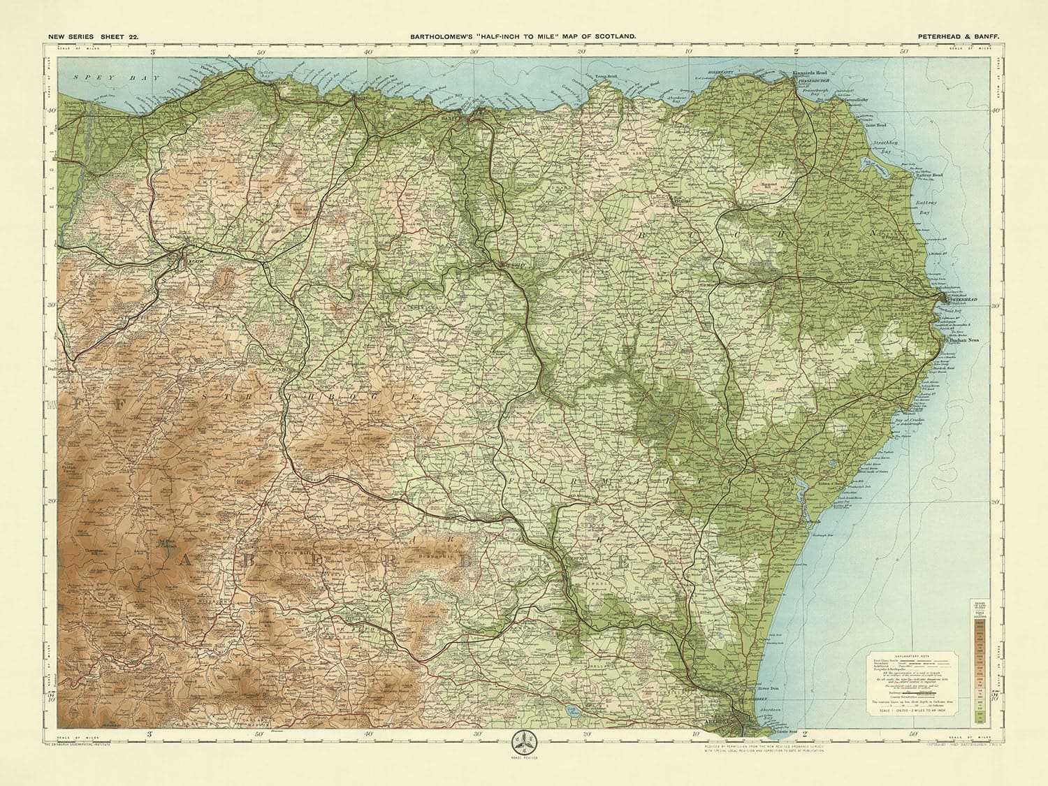
Fai un passo nel passato con l'esclusiva "Foglio 22 - Peterhead & Banff," una creazione magistrale del rinomato cartografo JG Bartholomew, datata...
Continua a leggereFai un passo nel passato con l'esclusiva "Foglio 22 - Peterhead & Banff," una creazione magistrale del rinomato cartografo JG Bartholomew, datata 1901. Questa mappa è una testimonianza dell'inesauribile competenza e visione artistica di Bartholomew, catturando l'essenza del paesaggio scozzese del primo XX secolo. Con i suoi dettagli meticolosi e colori vivaci, questa mappa è stata un pezzo di punta nella celebre serie di Bartholomew di mezzo pollice per miglio, amata da ciclisti e turisti. L'uso innovativo della gradazione di colore per rappresentare l'elevazione e il terreno offre una vista vivida, quasi tridimensionale della regione, rendendola sia uno strumento funzionale che un'opera d'arte.
La mappa di Bartholomew fornisce un ricco arazzo delle regioni di Peterhead e Banff, mostrando una vasta gamma di caratteristiche naturali e artificiali. La rappresentazione dettagliata di fiumi come il Deveron, Ythan, Don e Dee, insieme alle prominenti caratteristiche costiere del Moray Firth e della costa del Mare del Nord, dipinge un quadro completo delle vie d'acqua della zona. La mappa mette in evidenza anche foreste significative come la Foresta di Deer e la Foresta di Durris, così come colline e montagne notevoli tra cui Bennachie, Hill of Fare e Tap o' Noth, offrendo uno sguardo sulla topografia variegata della regione.
Il significato storico di questa mappa si estende oltre le sue caratteristiche geografiche. Include luoghi storici notevoli come il Castello di Slains, il Castello di Fyvie, il Castello di Huntly e il Castello di Craigievar, ognuno immerso in una ricca storia e grandezza architettonica. Questi punti di riferimento, accuratamente segnati sulla mappa, offrono una finestra sul passato leggendario della Scozia, rendendo questa mappa non solo un aiuto alla navigazione ma anche un documento storico. La presenza di questi castelli e di altri siti storici sottolinea la profondità culturale e storica della regione, invitando all'esplorazione e alla scoperta.
Oltre ai suoi punti di riferimento storici, la mappa è una testimonianza della crescente rete di trasporti dell'epoca. La Great North of Scotland Railway e la Highland Railway sono presentate in modo prominente, riflettendo i progressi industriali del periodo e l'importanza crescente della connettività. Queste ferrovie, insieme alla rappresentazione dettagliata di strade e sentieri, evidenziano l'utilità della mappa per i viaggiatori e gli avventurieri dell'epoca. Il design intricato della mappa e il suo dettaglio completo la rendono una risorsa inestimabile per comprendere il paesaggio e le infrastrutture scozzesi del primo XX secolo.
Il "Foglio 22 - Peterhead & Banff" di Bartholomew è più di una semplice mappa; è un pezzo di storia, un'opera d'arte e una testimonianza della competenza e della visione del cartografo. Cattura l'essenza di un'epoca passata, offrendo un ritratto dettagliato e vibrante della bellezza naturale della regione, dei punti di riferimento storici e delle infrastrutture in evoluzione. Che tu sia un appassionato di storia, un amante della fine cartografia o semplicemente qualcuno che apprezza la bellezza del paesaggio scozzese, questa mappa è un tesoro senza tempo che arricchirà la tua comprensione e apprezzamento del passato.
Città e paesi su questa mappa
- Aberdeenshire:
- Aberdeen
- Peterhead
- Fraserburgh
- Inverurie
- Ellon
- Huntly
- Turriff
- Oldmeldrum
- Banff
- Macduff
- Portsoy
- Cullen
- Keith
- Ballater
- Aboyne
- Banchory
- Stonehaven
- Laurencekirk
- Insch
- Alford
- Westhill
- Newburgh
- Cruden Bay
- Mintlaw
- Maud
- New Pitsligo
- Strichen
- Rosehearty
- Gardenstown
- Whitehills
- Portknockie
- Findochty
- Buckie
- Fochabers
- Dufftown
- Aberchirder
- Cuminestown
- New Deer
- Fyvie
- Tarves
- Methlick
- Newmachar
- Kintore
- Blackburn
- Balmedie
- Cove Bay
- Portlethen
- Newtonhill
- Inverbervie
- St. Cyrus
Caratteristiche e Luoghi di Interesse
- Fiumi e Corpi Idrici:
- Fiume Deveron
- Fiume Ythan
- Fiume Don
- Fiume Dee
- Loch di Strathbeg
- Loch di Skene
- Foreste e Boschi:
- Foresta di Deer
- Foresta di Durris
- Colline e Montagne:
- Bennachie
- Collina di Fare
- Collina Knock
- Tap o' Noth
- Caratteristiche Costiere:
- Moray Firth
- costa del Mare del Nord
- Spey Bay
- Trasporti:
- Great North of Scotland Railway
- Highland Railway
- Siti Storici:
- Castello di Slains
- Castello di Fyvie
- Castello di Huntly
- Castello di Craigievar
Contesto Storico e di Design
- Scala e scopo: Una mappa chiara, attraente e colorata in scala mezzo pollice per miglio (1:126,720). Queste mappe erano popolari tra ciclisti e turisti, e divennero la serie di punta di Bartholomew.
- Rappresentazione del rilievo: Le mappe a mezzo pollice erano distintive per l'uso di diversi strati di colore per rappresentare il rilievo del paesaggio, con una gradazione sottile e innovativa di bande di colore utilizzate per mostrare la terra a diverse altezze.
- Fonte: La mappa è basata su una mappa dell'Ordnance Survey ridotta dello stesso periodo.
- Data di creazione: 1901
- Cartografo o editore: JG Bartholomew
- Contesto sul cartografo: John George Bartholomew era un rinomato cartografo scozzese conosciuto per le sue mappe dettagliate e esteticamente piacevoli. Il suo lavoro ha contribuito in modo significativo al campo della cartografia.
- Argomenti e temi mostrati sulla mappa:
- Caratteristiche politiche e fisiche: La mappa dettaglia i confini politici e i paesaggi fisici, inclusi elevazione e terreno.
- Turismo e ciclismo: Riflette la popolarità del ciclismo e del turismo all'inizio del XX secolo.
- Paesi e regioni mostrati sulla mappa: Questa mappa copre parti della Scozia, specificamente le regioni attorno a Peterhead e Banff.
- Design o stile: La mappa presenta un'orientazione paesaggistica e impiega uno schema di colori stratificati per rappresentare l'elevazione e il terreno, migliorando la leggibilità e l'appeal estetico.
- Significato storico: Questa mappa è un documento storico prezioso, che riflette le tecniche cartografiche del primo XX secolo e il contesto socio-culturale dell'epoca, in particolare il crescente interesse per le attività all'aperto come il ciclismo e il turismo.
Si prega di controllare attentamente le immagini per assicurarsi che una specifica città o luogo sia mostrato su questa mappa. Puoi anche contattarci e chiedere di controllare la mappa per te.
Questa mappa appare ottima in ogni dimensione, ma consiglio sempre di optare per una dimensione più grande se hai spazio. In questo modo puoi facilmente distinguere tutti i dettagli.
Questa mappa sembra fantastica in dimensioni fino a 70 pollici (180 cm). Se stai cercando una mappa più grande, per favore contattaci.
Si prega di notare: le etichette su questa mappa sono difficili da leggere se si ordina una mappa di 20 pollici (50 cm) o più piccola. La mappa è comunque molto attraente, ma se desideri leggere la mappa facilmente, ti preghiamo di acquistare una dimensione più grande.
Il modello nelle immagini dell'inserzione sta tenendo la versione 18x24 pollici (45x60 cm) di questa mappa.
La quinta immagine dell'inserzione mostra un esempio del mio servizio di personalizzazione della mappa.
Se stai cercando qualcosa di leggermente diverso, dai un'occhiata alla mia collezione dei migliori mappe antiche per vedere se qualcos'altro attira la tua attenzione.
Per favore contattami per verificare se una certa posizione, un punto di riferimento o una caratteristica è mostrata su questa mappa.
Questo sarebbe un meraviglioso regalo di compleanno, Natale, Festa del Papà, addio al lavoro, anniversario o regalo per una nuova casa per qualcuno delle aree coperte da questa mappa.
Questa mappa è disponibile come stampa giclée su carta opaca archiviata senza acidi, oppure puoi acquistarla incorniciata. La cornice è una semplice cornice nera che si adatta alla maggior parte degli stili. Ti preghiamo di metterti in contatto se desideri un colore o un materiale della cornice diverso. Le mie cornici sono rivestite con acrilico super chiaro di grado museale (perspex/acrylite), che è significativamente meno riflettente del vetro, più sicuro e arriverà sempre in perfette condizioni.
This map is also available as a float framed canvas, sometimes known as a shadow gap framed canvas or canvas floater. The map is printed on artist's cotton canvas and then stretched over a handmade box frame. We then "float" the canvas inside a wooden frame, which is available in a range of colours (black, dark brown, oak, antique gold and white). This is a wonderful way to present a map without glazing in front. See some examples of float framed canvas maps and explore the differences between my different finishes.
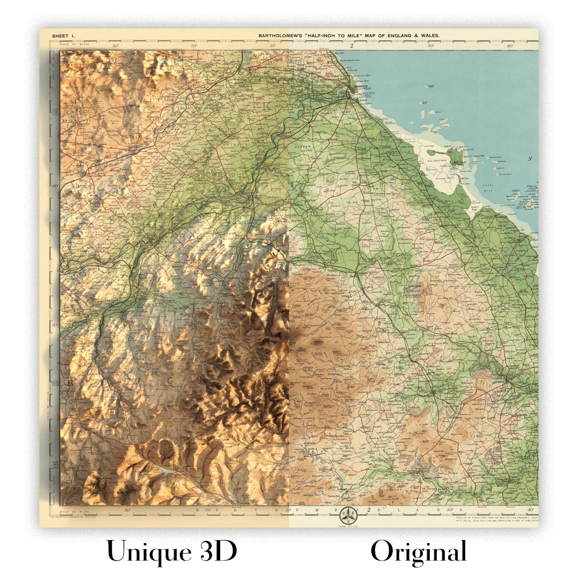
For something truly unique, this map is also available in "Unique 3D", our trademarked process that dramatically transforms the map so that it has a wonderful sense of depth. We combine the original map with detailed topography and elevation data, so that mountains and the terrain really "pop". For more info and examples of 3D maps, check my Unique 3D page.
Fai un passo nel passato con l'esclusiva "Foglio 22 - Peterhead & Banff," una creazione magistrale del rinomato cartografo JG Bartholomew, datata 1901. Questa mappa è una testimonianza dell'inesauribile competenza e visione artistica di Bartholomew, catturando l'essenza del paesaggio scozzese del primo XX secolo. Con i suoi dettagli meticolosi e colori vivaci, questa mappa è stata un pezzo di punta nella celebre serie di Bartholomew di mezzo pollice per miglio, amata da ciclisti e turisti. L'uso innovativo della gradazione di colore per rappresentare l'elevazione e il terreno offre una vista vivida, quasi tridimensionale della regione, rendendola sia uno strumento funzionale che un'opera d'arte.
La mappa di Bartholomew fornisce un ricco arazzo delle regioni di Peterhead e Banff, mostrando una vasta gamma di caratteristiche naturali e artificiali. La rappresentazione dettagliata di fiumi come il Deveron, Ythan, Don e Dee, insieme alle prominenti caratteristiche costiere del Moray Firth e della costa del Mare del Nord, dipinge un quadro completo delle vie d'acqua della zona. La mappa mette in evidenza anche foreste significative come la Foresta di Deer e la Foresta di Durris, così come colline e montagne notevoli tra cui Bennachie, Hill of Fare e Tap o' Noth, offrendo uno sguardo sulla topografia variegata della regione.
Il significato storico di questa mappa si estende oltre le sue caratteristiche geografiche. Include luoghi storici notevoli come il Castello di Slains, il Castello di Fyvie, il Castello di Huntly e il Castello di Craigievar, ognuno immerso in una ricca storia e grandezza architettonica. Questi punti di riferimento, accuratamente segnati sulla mappa, offrono una finestra sul passato leggendario della Scozia, rendendo questa mappa non solo un aiuto alla navigazione ma anche un documento storico. La presenza di questi castelli e di altri siti storici sottolinea la profondità culturale e storica della regione, invitando all'esplorazione e alla scoperta.
Oltre ai suoi punti di riferimento storici, la mappa è una testimonianza della crescente rete di trasporti dell'epoca. La Great North of Scotland Railway e la Highland Railway sono presentate in modo prominente, riflettendo i progressi industriali del periodo e l'importanza crescente della connettività. Queste ferrovie, insieme alla rappresentazione dettagliata di strade e sentieri, evidenziano l'utilità della mappa per i viaggiatori e gli avventurieri dell'epoca. Il design intricato della mappa e il suo dettaglio completo la rendono una risorsa inestimabile per comprendere il paesaggio e le infrastrutture scozzesi del primo XX secolo.
Il "Foglio 22 - Peterhead & Banff" di Bartholomew è più di una semplice mappa; è un pezzo di storia, un'opera d'arte e una testimonianza della competenza e della visione del cartografo. Cattura l'essenza di un'epoca passata, offrendo un ritratto dettagliato e vibrante della bellezza naturale della regione, dei punti di riferimento storici e delle infrastrutture in evoluzione. Che tu sia un appassionato di storia, un amante della fine cartografia o semplicemente qualcuno che apprezza la bellezza del paesaggio scozzese, questa mappa è un tesoro senza tempo che arricchirà la tua comprensione e apprezzamento del passato.
Città e paesi su questa mappa
- Aberdeenshire:
- Aberdeen
- Peterhead
- Fraserburgh
- Inverurie
- Ellon
- Huntly
- Turriff
- Oldmeldrum
- Banff
- Macduff
- Portsoy
- Cullen
- Keith
- Ballater
- Aboyne
- Banchory
- Stonehaven
- Laurencekirk
- Insch
- Alford
- Westhill
- Newburgh
- Cruden Bay
- Mintlaw
- Maud
- New Pitsligo
- Strichen
- Rosehearty
- Gardenstown
- Whitehills
- Portknockie
- Findochty
- Buckie
- Fochabers
- Dufftown
- Aberchirder
- Cuminestown
- New Deer
- Fyvie
- Tarves
- Methlick
- Newmachar
- Kintore
- Blackburn
- Balmedie
- Cove Bay
- Portlethen
- Newtonhill
- Inverbervie
- St. Cyrus
Caratteristiche e Luoghi di Interesse
- Fiumi e Corpi Idrici:
- Fiume Deveron
- Fiume Ythan
- Fiume Don
- Fiume Dee
- Loch di Strathbeg
- Loch di Skene
- Foreste e Boschi:
- Foresta di Deer
- Foresta di Durris
- Colline e Montagne:
- Bennachie
- Collina di Fare
- Collina Knock
- Tap o' Noth
- Caratteristiche Costiere:
- Moray Firth
- costa del Mare del Nord
- Spey Bay
- Trasporti:
- Great North of Scotland Railway
- Highland Railway
- Siti Storici:
- Castello di Slains
- Castello di Fyvie
- Castello di Huntly
- Castello di Craigievar
Contesto Storico e di Design
- Scala e scopo: Una mappa chiara, attraente e colorata in scala mezzo pollice per miglio (1:126,720). Queste mappe erano popolari tra ciclisti e turisti, e divennero la serie di punta di Bartholomew.
- Rappresentazione del rilievo: Le mappe a mezzo pollice erano distintive per l'uso di diversi strati di colore per rappresentare il rilievo del paesaggio, con una gradazione sottile e innovativa di bande di colore utilizzate per mostrare la terra a diverse altezze.
- Fonte: La mappa è basata su una mappa dell'Ordnance Survey ridotta dello stesso periodo.
- Data di creazione: 1901
- Cartografo o editore: JG Bartholomew
- Contesto sul cartografo: John George Bartholomew era un rinomato cartografo scozzese conosciuto per le sue mappe dettagliate e esteticamente piacevoli. Il suo lavoro ha contribuito in modo significativo al campo della cartografia.
- Argomenti e temi mostrati sulla mappa:
- Caratteristiche politiche e fisiche: La mappa dettaglia i confini politici e i paesaggi fisici, inclusi elevazione e terreno.
- Turismo e ciclismo: Riflette la popolarità del ciclismo e del turismo all'inizio del XX secolo.
- Paesi e regioni mostrati sulla mappa: Questa mappa copre parti della Scozia, specificamente le regioni attorno a Peterhead e Banff.
- Design o stile: La mappa presenta un'orientazione paesaggistica e impiega uno schema di colori stratificati per rappresentare l'elevazione e il terreno, migliorando la leggibilità e l'appeal estetico.
- Significato storico: Questa mappa è un documento storico prezioso, che riflette le tecniche cartografiche del primo XX secolo e il contesto socio-culturale dell'epoca, in particolare il crescente interesse per le attività all'aperto come il ciclismo e il turismo.
Si prega di controllare attentamente le immagini per assicurarsi che una specifica città o luogo sia mostrato su questa mappa. Puoi anche contattarci e chiedere di controllare la mappa per te.
Questa mappa appare ottima in ogni dimensione, ma consiglio sempre di optare per una dimensione più grande se hai spazio. In questo modo puoi facilmente distinguere tutti i dettagli.
Questa mappa sembra fantastica in dimensioni fino a 70 pollici (180 cm). Se stai cercando una mappa più grande, per favore contattaci.
Si prega di notare: le etichette su questa mappa sono difficili da leggere se si ordina una mappa di 20 pollici (50 cm) o più piccola. La mappa è comunque molto attraente, ma se desideri leggere la mappa facilmente, ti preghiamo di acquistare una dimensione più grande.
Il modello nelle immagini dell'inserzione sta tenendo la versione 18x24 pollici (45x60 cm) di questa mappa.
La quinta immagine dell'inserzione mostra un esempio del mio servizio di personalizzazione della mappa.
Se stai cercando qualcosa di leggermente diverso, dai un'occhiata alla mia collezione dei migliori mappe antiche per vedere se qualcos'altro attira la tua attenzione.
Per favore contattami per verificare se una certa posizione, un punto di riferimento o una caratteristica è mostrata su questa mappa.
Questo sarebbe un meraviglioso regalo di compleanno, Natale, Festa del Papà, addio al lavoro, anniversario o regalo per una nuova casa per qualcuno delle aree coperte da questa mappa.
Questa mappa è disponibile come stampa giclée su carta opaca archiviata senza acidi, oppure puoi acquistarla incorniciata. La cornice è una semplice cornice nera che si adatta alla maggior parte degli stili. Ti preghiamo di metterti in contatto se desideri un colore o un materiale della cornice diverso. Le mie cornici sono rivestite con acrilico super chiaro di grado museale (perspex/acrylite), che è significativamente meno riflettente del vetro, più sicuro e arriverà sempre in perfette condizioni.
This map is also available as a float framed canvas, sometimes known as a shadow gap framed canvas or canvas floater. The map is printed on artist's cotton canvas and then stretched over a handmade box frame. We then "float" the canvas inside a wooden frame, which is available in a range of colours (black, dark brown, oak, antique gold and white). This is a wonderful way to present a map without glazing in front. See some examples of float framed canvas maps and explore the differences between my different finishes.
For something truly unique, this map is also available in "Unique 3D", our trademarked process that dramatically transforms the map so that it has a wonderful sense of depth. We combine the original map with detailed topography and elevation data, so that mountains and the terrain really "pop". For more info and examples of 3D maps, check my Unique 3D page.
Many of our maps and art prints are chosen as thoughtful gifts for homes, offices, studies and meaningful places.
Choose a framed option for the easiest ready-to-hang gift, or choose an unframed print if the recipient may prefer to select their own frame.
We make orders locally in 23 countries around the world, so gifts can often be produced close to the recipient. This helps them arrive faster, travel more safely, and avoid customs or import duty surprises.
- We can deliver directly to the recipient
- Framed pieces arrive ready to hang
- Unframed prints are carefully packed in a strong protective tube
- Almost every order is made locally, for faster, safer gifting
- 90-day returns give the recipient time to decide
If you are not sure what to choose, please contact us. We can help you pick the right map, size, finish or delivery option.
Most orders are made locally and delivered in around 2–3 working days, depending on the product, size and destination.
We print and frame maps and artwork in 23 countries around the world, so your order is usually made close to you or your recipient. That means faster delivery, less time in transit, and no customs or import duty surprises.
Personalised and customised pieces usually take an extra 1–2 working days, because we prepare your design and send it to you for approval before printing.
Very large framed orders can take a little longer, as they need extra care in production and delivery.
Every order is carefully packaged: unframed prints are sent in a strong protective tube, while framed pieces are securely packed with protective materials around the frame.
If you need your order by a particular date, please contact us before ordering. We’ll check the best production route and delivery option for your location.
Express delivery is available at checkout for most countries. Next-day delivery is available in the UK, US, Singapore and the UAE.
Your order is covered by our 90-day returns policy and 10-year guarantee.
Our standard frame is a gallery-style black ash hardwood frame, with a simple, modern look. It is approximately 20mm (0.8in) wide. You can also view some lovely customer photos of framed maps and art.
We use super-clear acrylic glazing, also known as Perspex or Acrylite, instead of traditional glass. It is lighter, safer, and has lower reflectivity, giving the artwork a clearer, cleaner appearance.
Six standard frame colours are available at no extra cost: black, dark brown, dark grey, oak, white, and antique gold. Custom framing and mounting/matting is also available for customers looking for something more specific.
Most maps, art prints, and illustrations are also available as a framed canvas. We use matte cotton canvas, stretch it over a sustainably sourced wooden box frame, and then float the piece within a wooden outer frame. The finished result is beautifully presented, with no glazing between you and the artwork.
All frames are supplied ready to hang, with either string or brackets fitted to the back. Very large frames will include heavy-duty hanging plates and/or a mounting baton. If you have any questions, please get in touch.
We can also supply old maps and artwork on canvas, foam board, cotton rag, and other materials.
If you would prefer to frame your map or artwork yourself, please read our size guide before ordering.
My maps are extremely high quality reproductions of original maps.
I source original, rare maps from libraries, auction houses and private collections around the world, restore them at my London workshop, and then use specialist giclée inks and printers to create beautiful maps that look even better than the original.
My maps are printed on acid-free archival matte (not glossy) paper that feels very high quality and almost like card. In technical terms the paper weight/thickness is 10mil/200gsm. It's perfect for framing.
I print with Epson ultrachrome giclée UV fade resistant pigment inks - some of the best inks you can find.
I can also make maps on canvas, cotton rag and other exotic materials.
Learn more about The Unique Maps Co.
Map personalisation
If you're looking for the perfect anniversary or housewarming gift, I can personalise your map to make it truly unique. For example, I can add a short message, or highlight an important location, or add your family's coat of arms.
The options are almost infinite. Please see my map personalisation page for some wonderful examples of what's possible.
To order a personalised map, select "personalise your map" before adding it to your basket.
Get in touch if you're looking for more complex customisations and personalisations.
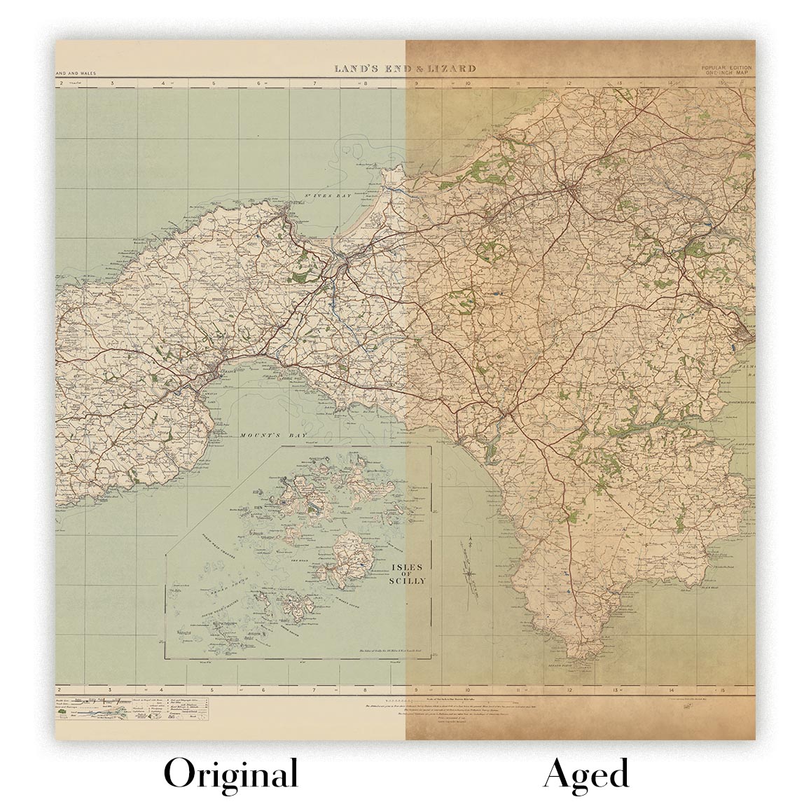
Map ageing
I have been asked hundreds of times over the years by customers if they could buy a map that looks even older.
Well, now you can, by selecting Aged before you add a map to your basket.
All the product photos you see on this page show the map in its Original form. This is what the map looks like today.
If you select Aged, I will age your map by hand, using a special and unique process developed through years of studying old maps, talking to researchers to understand the chemistry of aging paper, and of course... lots of practice!
If you're unsure, stick to the Original colour of the map. If you want something a bit darker and older looking, go for Aged.
Se non sei soddisfatto del tuo ordine per qualsiasi motivo, contattami per un rimborso senza problemi. Si prega di consultare la nostra politica di reso e rimborso per ulteriori informazioni.
Sono molto sicuro che ti piacerà la tua mappa restaurata o la stampa d'arte. Lo faccio dal 1984. Sono un venditore Etsy a 5 stelle. Ho venduto decine di migliaia di mappe e stampe d'arte e ho oltre 5.000 recensioni reali a 5 stelle.
Utilizzo un processo unico per restaurare mappe e opere d'arte che richiede molto tempo e lavoro. Trovare le mappe e le illustrazioni originali può richiedere mesi. Utilizzo tecnologia all'avanguardia e incredibilmente costosa per scannerizzare e restaurarle. Di conseguenza, garantisco che le mie mappe e stampe d'arte siano superiori alle altre - ecco perché posso offrire un rimborso senza problemi.
Quasi tutte le mie mappe e stampe d'arte sembrano fantastiche a grandi dimensioni (200 cm, 6,5 piedi+) e posso anche incorniciarle e consegnarle a te, tramite un corriere speciale per oggetti di grandi dimensioni. Contattami per discutere delle tue esigenze specifiche.
Or try searching for something!


