


Vecchia mappa pittorica della Jugoslavia di Kopac, 1959: Belgrado, Zagabria, Mare Adriatico, Castelli, Montagne
L’offerta del Collezionista
Scegli due opere idonee e ricevi il 20% di sconto su entrambe. Scegline tre e quella al prezzo più basso è in omaggio, con un risparmio massimo del 33%.
Abbina liberamente mappe standard idonee e stampe d’arte fine art. Non è richiesto alcun codice; l’offerta viene applicata automaticamente al checkout.
Sono incluse le configurazioni standard su ordinazione. Sono esclusi formati su misura, design personalizzati e lavori su commissione.
Hai bisogno di consegne a indirizzi diversi? Contattaci prima di effettuare l’ordine.L’offerta del Collezionista
Scegli due opere idonee e ricevi il 20% di sconto su entrambe. Scegline tre e quella al prezzo più basso è in omaggio, con un risparmio massimo del 33%.
Abbina liberamente mappe standard idonee e stampe d’arte fine art. Non è richiesto alcun codice; l’offerta viene applicata automaticamente al checkout.
Sono incluse le configurazioni standard su ordinazione. Sono esclusi formati su misura, design personalizzati e lavori su commissione.
Hai bisogno di consegne a indirizzi diversi? Contattaci prima di effettuare l’ordine. Restaurato a Londra • Prodotto in Canada

Restaurata dalla mappa originale del 1959 e stampata in qualità museale. Leggi la storia dietro questa mappa
Choose your size
Choose your finish


(Maggiori informazioni)
Gift message & custom finish

If you want to add a gift message, or a finish (jigsaw, aluminium board, etc.) that is not available here, please request it in the "order note" when you check out.
Every order is custom made, so if you need the size adjusted slightly, or printed on an unusual material, just let us know. We've done thousands of custom orders over the years, so there's (almost) nothing we can't manage.
You can also contact us before you order, if you prefer!

- Prodotto localmente. Consegna sicura
- Nessun dazio o costo nascosto
- Serve aiuto? Chiamaci o messaggio su WhatsApp
Own a piece of history
8,000+ five-star reviews


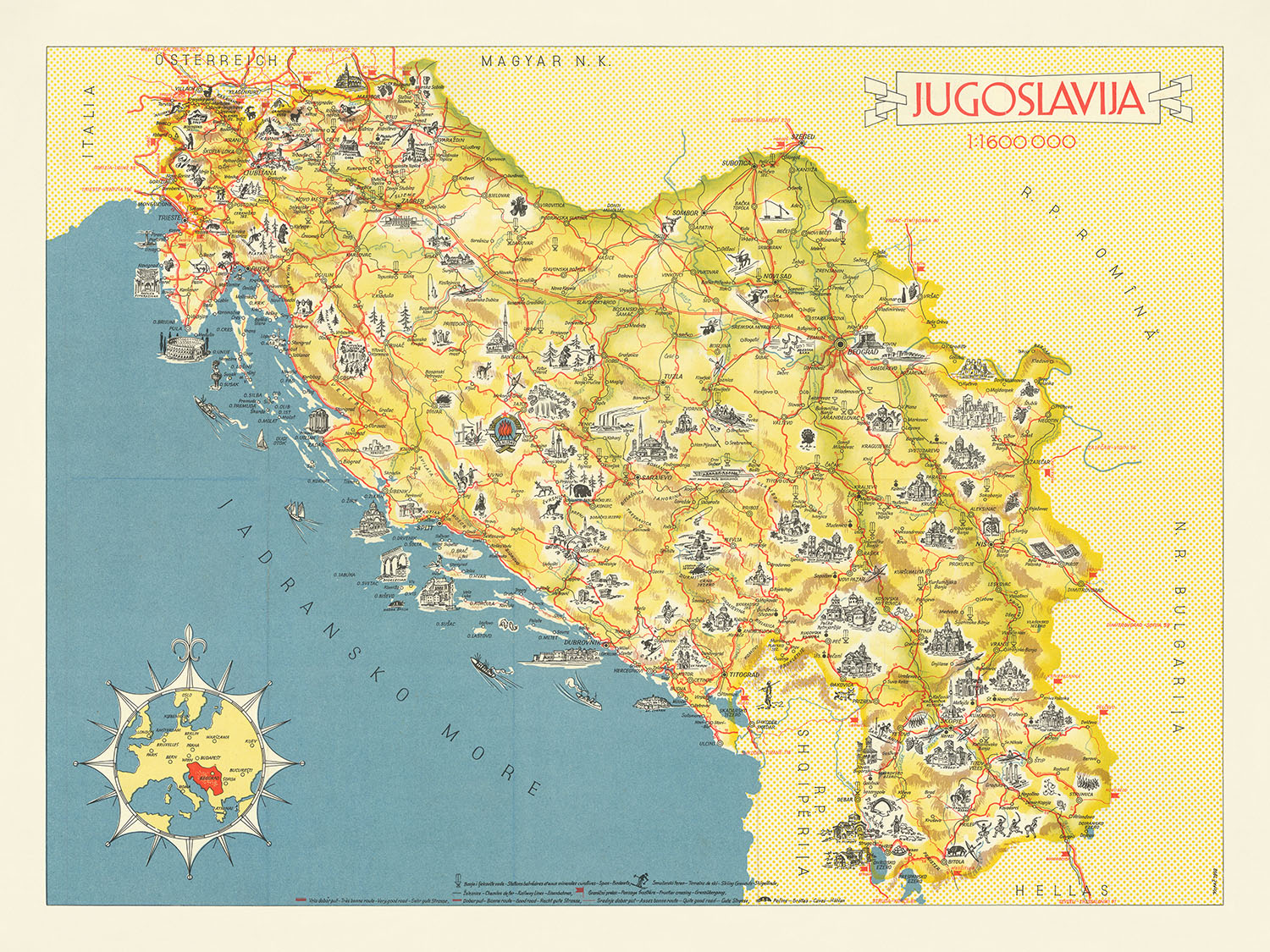
La mappa intitolata "Jugoslavija," creata dal rinomato cartografo Vlasto Kopac nel 1959, offre una rappresentazione vivace e illustrativa della Jugoslavia così com'era...
Continua a leggereLa mappa intitolata "Jugoslavija," creata dal rinomato cartografo Vlasto Kopac nel 1959, offre una rappresentazione vivace e illustrativa della Jugoslavia così com'era a metà del XX secolo. Kopac, noto per le sue opere cartografiche dettagliate e artistiche, cattura magistralmente l'essenza di una nazione ricca di patrimonio culturale e significato storico. Questa mappa pittorica non è solo una rappresentazione geografica, ma un viaggio visivo attraverso i paesaggi diversi e dinamici della Jugoslavia, adornata da illustrazioni colorate che simboleggiano i punti di riferimento culturali, i siti storici e le attività economiche della regione.
La mappa di Kopac è un arazzo vivace che intreccia i dettagli intricati della vita, del patrimonio e del turismo jugoslavo. Ogni illustrazione pittorica è una testimonianza della ricca storia e della vibrante cultura del paese, dai maestosi castelli e antiche chiese ai mercati affollati e alle serene scene costiere lungo il Mare Adriatico. Il verso della mappa arricchisce ulteriormente l'esperienza con immagini e pannelli di testo che approfondiscono aspetti specifici della vita jugoslava, offrendo una comprensione più profonda dell'identità e del fascino della nazione.
L'estensione geografica della Jugoslavia è meticolosamente dettagliata, mostrando i suoi confini con paesi vicini come Italia, Austria, Ungheria, Romania, Bulgaria, Grecia e Albania. La mappa evidenzia la topografia diversificata della regione, dalle aspre catene montuose che attraversano il paesaggio alle acque tranquille del Mare Adriatico. Questa rappresentazione dettagliata non solo funge da strumento di navigazione, ma anche da documento storico che cattura l'essenza di una nazione sull'orlo di significativi cambiamenti politici e sociali.
Città e paesi sono presentati in modo prominente, ciascuno contrassegnato da un'illustrazione che riflette il suo carattere e significato unici. Dalla vivace capitale di Belgrado alla storica città di Dubrovnik, la mappa fornisce un'istantanea della vita urbana nella Jugoslavia a metà del XX secolo. Anche i paesi e i villaggi più piccoli sono rappresentati, ciascuno contribuendo al ricco arazzo del paesaggio culturale ed economico della nazione. Questa rappresentazione urbana dettagliata sottolinea il valore della mappa sia come artefatto storico che come opera d'arte.
Gli elementi tematici della mappa si estendono oltre la semplice geografia, offrendo spunti sulle attività economiche che hanno definito la regione. Illustrazioni di campi agricoli, siti industriali e rotte commerciali offrono uno sguardo sulle fonti di sostentamento del popolo jugoslavo. Questa fusione di temi culturali, storici ed economici rende la mappa di Kopac un pezzo unico e inestimabile per collezionisti e storici, catturando lo spirito di una nazione durante un momento cruciale della sua storia.
Città e paesi su questa mappa
- Belgrado (Beograd)
- Zagabria
- Skopje
- Sarajevo
- Lubiana
- Spalato
- Novi Sad
- Fiume
- Maribor
- Podgorica (Titograd)
- Banja Luka
- Osijek
- Niš
- Kragujevac
- Subotica
- Zara
- Pola
- Dubrovnik
- Šibenik
- Mostar
- Bitola
- Pristina
- Koper
- Tuzla
- Varaždin
- Kraljevo
- Karlovac
- Vranje
- Veles
- Herceg Novi
- Sombor
- Smederevo
- Bijeljina
- Murska Sobota
- Čačak
- Kikinda
- Pirot
- Vršac
- Prokuplje
- Knin
- Gospić
- Novi Pazar
- Valjevo
- Trebinje
- Vinkovci
- Vukovar
- Pančevo
- Leskovac
- Zrenjanin
- Kumanovo
- Krško
- Kotor
- Sremska Mitrovica
- Štip
- Prijedor
- Ptuj
- Bjelovar
- Čakovec
- Požarevac
- Berane
- Kavadarci
Caratteristiche e Monumenti Notabili
- Mappe in dettaglio:
- Piccola mappa in dettaglio che mostra la posizione della Jugoslavia in Europa.
- Illustrazioni:
- Varie illustrazioni che rappresentano monumenti culturali, siti storici e attività economiche.
- Monumenti:
- Numerosi monumenti culturali e storici, come castelli, chiese e monumenti.
- Corpi idrici:
- Mare Adriatico (Jadransko More).
- Confini:
- Confini con Italia, Austria, Ungheria, Romania, Bulgaria, Grecia e Albania.
- Montagne:
- Illustrazioni delle catene montuose in tutta la Jugoslavia.
Contesto Storico e di Design
- Nome della mappa: Jugoslavija
- Quando è stata realizzata la mappa: 1959
- Cartografo o editore: Vlasto Kopac
- Contesto interessante sul cartografo: Vlasto Kopac era conosciuto per le sue opere cartografiche dettagliate e illustrative, spesso catturando l'essenza culturale e storica delle regioni.
- Temi e argomenti mostrati sulla mappa:
- Monumenti culturali: Illustrazioni che raffigurano siti culturali significativi.
- Siti storici: Vari monumenti storici sono illustrati.
- Attività economiche: Rappresentazioni simboliche delle attività economiche prevalenti nella regione.
- Turismo: Sottolinea attrazioni turistiche e punti di interesse.
- Paesi e regioni mostrati sulla mappa:
- Jugoslavia com'era negli anni '50 del XX secolo.
- Paesi confinanti: Italia, Austria (Österreich), Ungheria (Magyar N.K.), Romania (R.P.ROMINĂ), Bulgaria (N.R. BUGARIA), Grecia (Hellas) e Albania.
- Design o stile della mappa:
- Pittorico e tematico, con un focus su elementi colorati e illustrativi.
- La mappa include una rosa dei venti decorativa e una piccola mappa in dettaglio che mostra la posizione della Jugoslavia in Europa.
- Significato storico o contesto della mappa:
- La mappa cattura la Jugoslavia durante un periodo di significativo cambiamento politico e sociale a metà del XX secolo.
- Funziona come un documento storico che riflette gli aspetti culturali, economici e geografici della Jugoslavia prima della sua dissoluzione negli anni '90.
Si prega di controllare attentamente le immagini per assicurarsi che una specifica città o luogo sia mostrato su questa mappa. Puoi anche contattarci e chiedere di controllare la mappa per te.
Questa mappa appare fantastica in ogni dimensione, ma consiglio sempre di optare per una dimensione più grande se hai spazio. In questo modo puoi facilmente distinguere tutti i dettagli.
Questa mappa sembra incredibile in dimensioni fino a 90in (230cm). Se stai cercando una mappa più grande, per favore contattaci.
Il modello nelle immagini dell'annuncio tiene la versione 18x24in (45x60cm) di questa mappa.
La quinta immagine dell'annuncio mostra un esempio del mio servizio di personalizzazione della mappa.
Se stai cercando qualcosa di leggermente diverso, dai un'occhiata alla mia collezione delle migliori mappe antiche per vedere se qualcosa cattura la tua attenzione.
Per favore contattami per controllare se una certa posizione, punto di riferimento o caratteristica è mostrata su questa mappa.
Questo sarebbe un meraviglioso regalo di compleanno, Natale, Festa del Papà, partenza dal lavoro, anniversario o regalo per una nuova casa per qualcuno delle aree coperte da questa mappa.
Questa mappa è disponibile come stampa giclée su carta opaca archiviata senza acidi, oppure puoi acquistarla incorniciata. La cornice è una semplice cornice nera che si adatta alla maggior parte delle estetiche. Per favore contattami se desideri un colore o materiale diverso per la cornice. Le mie cornici sono rivestite con un acrilico museo super trasparente (perspex/acrylite), che è significativamente meno riflettente del vetro, più sicuro e arriverà sempre in condizioni perfette.
This map is also available as a float framed canvas, sometimes known as a shadow gap framed canvas or canvas floater. The map is printed on artist's cotton canvas and then stretched over a handmade box frame. We then "float" the canvas inside a wooden frame, which is available in a range of colours (black, dark brown, oak, antique gold and white). This is a wonderful way to present a map without glazing in front. See some examples of float framed canvas maps and explore the differences between my different finishes.
For something truly unique, this map is also available in "Unique 3D", our trademarked process that dramatically transforms the map so that it has a wonderful sense of depth. We combine the original map with detailed topography and elevation data, so that mountains and the terrain really "pop". For more info and examples of 3D maps, check my Unique 3D page.
La mappa intitolata "Jugoslavija," creata dal rinomato cartografo Vlasto Kopac nel 1959, offre una rappresentazione vivace e illustrativa della Jugoslavia così com'era a metà del XX secolo. Kopac, noto per le sue opere cartografiche dettagliate e artistiche, cattura magistralmente l'essenza di una nazione ricca di patrimonio culturale e significato storico. Questa mappa pittorica non è solo una rappresentazione geografica, ma un viaggio visivo attraverso i paesaggi diversi e dinamici della Jugoslavia, adornata da illustrazioni colorate che simboleggiano i punti di riferimento culturali, i siti storici e le attività economiche della regione.
La mappa di Kopac è un arazzo vivace che intreccia i dettagli intricati della vita, del patrimonio e del turismo jugoslavo. Ogni illustrazione pittorica è una testimonianza della ricca storia e della vibrante cultura del paese, dai maestosi castelli e antiche chiese ai mercati affollati e alle serene scene costiere lungo il Mare Adriatico. Il verso della mappa arricchisce ulteriormente l'esperienza con immagini e pannelli di testo che approfondiscono aspetti specifici della vita jugoslava, offrendo una comprensione più profonda dell'identità e del fascino della nazione.
L'estensione geografica della Jugoslavia è meticolosamente dettagliata, mostrando i suoi confini con paesi vicini come Italia, Austria, Ungheria, Romania, Bulgaria, Grecia e Albania. La mappa evidenzia la topografia diversificata della regione, dalle aspre catene montuose che attraversano il paesaggio alle acque tranquille del Mare Adriatico. Questa rappresentazione dettagliata non solo funge da strumento di navigazione, ma anche da documento storico che cattura l'essenza di una nazione sull'orlo di significativi cambiamenti politici e sociali.
Città e paesi sono presentati in modo prominente, ciascuno contrassegnato da un'illustrazione che riflette il suo carattere e significato unici. Dalla vivace capitale di Belgrado alla storica città di Dubrovnik, la mappa fornisce un'istantanea della vita urbana nella Jugoslavia a metà del XX secolo. Anche i paesi e i villaggi più piccoli sono rappresentati, ciascuno contribuendo al ricco arazzo del paesaggio culturale ed economico della nazione. Questa rappresentazione urbana dettagliata sottolinea il valore della mappa sia come artefatto storico che come opera d'arte.
Gli elementi tematici della mappa si estendono oltre la semplice geografia, offrendo spunti sulle attività economiche che hanno definito la regione. Illustrazioni di campi agricoli, siti industriali e rotte commerciali offrono uno sguardo sulle fonti di sostentamento del popolo jugoslavo. Questa fusione di temi culturali, storici ed economici rende la mappa di Kopac un pezzo unico e inestimabile per collezionisti e storici, catturando lo spirito di una nazione durante un momento cruciale della sua storia.
Città e paesi su questa mappa
- Belgrado (Beograd)
- Zagabria
- Skopje
- Sarajevo
- Lubiana
- Spalato
- Novi Sad
- Fiume
- Maribor
- Podgorica (Titograd)
- Banja Luka
- Osijek
- Niš
- Kragujevac
- Subotica
- Zara
- Pola
- Dubrovnik
- Šibenik
- Mostar
- Bitola
- Pristina
- Koper
- Tuzla
- Varaždin
- Kraljevo
- Karlovac
- Vranje
- Veles
- Herceg Novi
- Sombor
- Smederevo
- Bijeljina
- Murska Sobota
- Čačak
- Kikinda
- Pirot
- Vršac
- Prokuplje
- Knin
- Gospić
- Novi Pazar
- Valjevo
- Trebinje
- Vinkovci
- Vukovar
- Pančevo
- Leskovac
- Zrenjanin
- Kumanovo
- Krško
- Kotor
- Sremska Mitrovica
- Štip
- Prijedor
- Ptuj
- Bjelovar
- Čakovec
- Požarevac
- Berane
- Kavadarci
Caratteristiche e Monumenti Notabili
- Mappe in dettaglio:
- Piccola mappa in dettaglio che mostra la posizione della Jugoslavia in Europa.
- Illustrazioni:
- Varie illustrazioni che rappresentano monumenti culturali, siti storici e attività economiche.
- Monumenti:
- Numerosi monumenti culturali e storici, come castelli, chiese e monumenti.
- Corpi idrici:
- Mare Adriatico (Jadransko More).
- Confini:
- Confini con Italia, Austria, Ungheria, Romania, Bulgaria, Grecia e Albania.
- Montagne:
- Illustrazioni delle catene montuose in tutta la Jugoslavia.
Contesto Storico e di Design
- Nome della mappa: Jugoslavija
- Quando è stata realizzata la mappa: 1959
- Cartografo o editore: Vlasto Kopac
- Contesto interessante sul cartografo: Vlasto Kopac era conosciuto per le sue opere cartografiche dettagliate e illustrative, spesso catturando l'essenza culturale e storica delle regioni.
- Temi e argomenti mostrati sulla mappa:
- Monumenti culturali: Illustrazioni che raffigurano siti culturali significativi.
- Siti storici: Vari monumenti storici sono illustrati.
- Attività economiche: Rappresentazioni simboliche delle attività economiche prevalenti nella regione.
- Turismo: Sottolinea attrazioni turistiche e punti di interesse.
- Paesi e regioni mostrati sulla mappa:
- Jugoslavia com'era negli anni '50 del XX secolo.
- Paesi confinanti: Italia, Austria (Österreich), Ungheria (Magyar N.K.), Romania (R.P.ROMINĂ), Bulgaria (N.R. BUGARIA), Grecia (Hellas) e Albania.
- Design o stile della mappa:
- Pittorico e tematico, con un focus su elementi colorati e illustrativi.
- La mappa include una rosa dei venti decorativa e una piccola mappa in dettaglio che mostra la posizione della Jugoslavia in Europa.
- Significato storico o contesto della mappa:
- La mappa cattura la Jugoslavia durante un periodo di significativo cambiamento politico e sociale a metà del XX secolo.
- Funziona come un documento storico che riflette gli aspetti culturali, economici e geografici della Jugoslavia prima della sua dissoluzione negli anni '90.
Si prega di controllare attentamente le immagini per assicurarsi che una specifica città o luogo sia mostrato su questa mappa. Puoi anche contattarci e chiedere di controllare la mappa per te.
Questa mappa appare fantastica in ogni dimensione, ma consiglio sempre di optare per una dimensione più grande se hai spazio. In questo modo puoi facilmente distinguere tutti i dettagli.
Questa mappa sembra incredibile in dimensioni fino a 90in (230cm). Se stai cercando una mappa più grande, per favore contattaci.
Il modello nelle immagini dell'annuncio tiene la versione 18x24in (45x60cm) di questa mappa.
La quinta immagine dell'annuncio mostra un esempio del mio servizio di personalizzazione della mappa.
Se stai cercando qualcosa di leggermente diverso, dai un'occhiata alla mia collezione delle migliori mappe antiche per vedere se qualcosa cattura la tua attenzione.
Per favore contattami per controllare se una certa posizione, punto di riferimento o caratteristica è mostrata su questa mappa.
Questo sarebbe un meraviglioso regalo di compleanno, Natale, Festa del Papà, partenza dal lavoro, anniversario o regalo per una nuova casa per qualcuno delle aree coperte da questa mappa.
Questa mappa è disponibile come stampa giclée su carta opaca archiviata senza acidi, oppure puoi acquistarla incorniciata. La cornice è una semplice cornice nera che si adatta alla maggior parte delle estetiche. Per favore contattami se desideri un colore o materiale diverso per la cornice. Le mie cornici sono rivestite con un acrilico museo super trasparente (perspex/acrylite), che è significativamente meno riflettente del vetro, più sicuro e arriverà sempre in condizioni perfette.
This map is also available as a float framed canvas, sometimes known as a shadow gap framed canvas or canvas floater. The map is printed on artist's cotton canvas and then stretched over a handmade box frame. We then "float" the canvas inside a wooden frame, which is available in a range of colours (black, dark brown, oak, antique gold and white). This is a wonderful way to present a map without glazing in front. See some examples of float framed canvas maps and explore the differences between my different finishes.
For something truly unique, this map is also available in "Unique 3D", our trademarked process that dramatically transforms the map so that it has a wonderful sense of depth. We combine the original map with detailed topography and elevation data, so that mountains and the terrain really "pop". For more info and examples of 3D maps, check my Unique 3D page.
Many of our maps and art prints are chosen as thoughtful gifts for homes, offices, studies and meaningful places.
Choose a framed option for the easiest ready-to-hang gift, or choose an unframed print if the recipient may prefer to select their own frame.
We make orders locally in 23 countries around the world, so gifts can often be produced close to the recipient. This helps them arrive faster, travel more safely, and avoid customs or import duty surprises.
- We can deliver directly to the recipient
- Framed pieces arrive ready to hang
- Unframed prints are carefully packed in a strong protective tube
- Almost every order is made locally, for faster, safer gifting
- 90-day returns give the recipient time to decide
If you are not sure what to choose, please contact us. We can help you pick the right map, size, finish or delivery option.
Most orders are made locally and delivered in around 2–3 working days, depending on the product, size and destination.
We print and frame maps and artwork in 23 countries around the world, so your order is usually made close to you or your recipient. That means faster delivery, less time in transit, and no customs or import duty surprises.
Personalised and customised pieces usually take an extra 1–2 working days, because we prepare your design and send it to you for approval before printing.
Very large framed orders can take a little longer, as they need extra care in production and delivery.
Every order is carefully packaged: unframed prints are sent in a strong protective tube, while framed pieces are securely packed with protective materials around the frame.
If you need your order by a particular date, please contact us before ordering. We’ll check the best production route and delivery option for your location.
Express delivery is available at checkout for most countries. Next-day delivery is available in the UK, US, Singapore and the UAE.
Your order is covered by our 90-day returns policy and 10-year guarantee.
Our standard frame is a gallery-style black ash hardwood frame, with a simple, modern look. It is approximately 20mm (0.8in) wide. You can also view some lovely customer photos of framed maps and art.
We use super-clear acrylic glazing, also known as Perspex or Acrylite, instead of traditional glass. It is lighter, safer, and has lower reflectivity, giving the artwork a clearer, cleaner appearance.
Six standard frame colours are available at no extra cost: black, dark brown, dark grey, oak, white, and antique gold. Custom framing and mounting/matting is also available for customers looking for something more specific.
Most maps, art prints, and illustrations are also available as a framed canvas. We use matte cotton canvas, stretch it over a sustainably sourced wooden box frame, and then float the piece within a wooden outer frame. The finished result is beautifully presented, with no glazing between you and the artwork.
All frames are supplied ready to hang, with either string or brackets fitted to the back. Very large frames will include heavy-duty hanging plates and/or a mounting baton. If you have any questions, please get in touch.
We can also supply old maps and artwork on canvas, foam board, cotton rag, and other materials.
If you would prefer to frame your map or artwork yourself, please read our size guide before ordering.
Every Unique Maps piece begins with an authentic cartographic source or an original design from our London studio.
For our historic maps, we source rare originals from libraries, archives, auction houses and private collections around the world. We carefully restore each map for print—repairing age-related damage, balancing colour and improving clarity while preserving its original detail, texture and character.
Once restored, the map is prepared for your chosen size and finish. Your piece is then printed and, where selected, framed close to its delivery destination.
Our map prints use acid-free 200gsm archival matte paper and fade-resistant pigment inks, creating a rich, non-glossy finish designed to last. Framed maps use crystal-clear optical acrylic and arrive ready to hang.
Canvas, cotton-rag and other specialist presentations are also available. Learn more about our materials and finishes.
Personalising your map
You can add a short title or dedication, mark one meaningful place, or request one considered visual detail. For personalised designs, we send a proof before printing and you can request changes before approval.
For more complex bespoke commissions, contact our design team.
Original or Aged
Choose Original for true-to-source colour, or Aged for a warmer, richer antique character created with our specialist ageing process. See examples of our Aged maps.
Se non sei soddisfatto del tuo ordine per qualsiasi motivo, contattami per un rimborso senza problemi. Si prega di consultare la nostra politica di reso e rimborso per ulteriori informazioni.
Sono molto sicuro che ti piacerà la tua mappa restaurata o la stampa d'arte. Lo faccio dal 1984. Sono un venditore Etsy a 5 stelle. Ho venduto decine di migliaia di mappe e stampe d'arte e ho oltre 5.000 recensioni reali a 5 stelle.
Utilizzo un processo unico per restaurare mappe e opere d'arte che richiede molto tempo e lavoro. Trovare le mappe e le illustrazioni originali può richiedere mesi. Utilizzo tecnologia all'avanguardia e incredibilmente costosa per scannerizzare e restaurarle. Di conseguenza, garantisco che le mie mappe e stampe d'arte siano superiori alle altre - ecco perché posso offrire un rimborso senza problemi.
Quasi tutte le mie mappe e stampe d'arte sembrano fantastiche a grandi dimensioni (200 cm, 6,5 piedi+) e posso anche incorniciarle e consegnarle a te, tramite un corriere speciale per oggetti di grandi dimensioni. Contattami per discutere delle tue esigenze specifiche.
Or try searching for something!


