


Mappa molto grande della Terra Santa e di Gerusalemme di Haines, 1828: fatta in America, Esodo, Sinai, Tempio di Salomone, Betlemme
20% di sconto su 2 — 33% di sconto su 3
Aggiungi qualsiasi due articoli idonei al tuo carrello per ricevere 20% di sconto. Aggiungi un terzo e sarà gratuito (equivalente a 33% di sconto quando acquisti tre).
Nessun codice necessario — l'offerta si applica automaticamente al checkout.
Valido su tutte le mappe standard e le stampe d'arte fine. Puoi mescolare e abbinare qualsiasi design.
Se desideri spedire articoli a più indirizzi, ti preghiamo di contattarci prima di effettuare il tuo ordine.
Le commissioni personalizzate e su misura sono escluse.
Contattaci se hai domande
 Progettato a Londra Prodotto in Canada
Progettato a Londra • Prodotto in Canada
Progettato a Londra Prodotto in Canada
Progettato a Londra • Prodotto in Canada

Restaurata dalla mappa originale del 1828 e stampata in qualità museale. Leggi la storia dietro questa mappa
Choose your size
Choose your finish


(Maggiori informazioni)
Gift message & custom finish

If you want to add a gift message, or a finish (jigsaw, aluminium board, etc.) that is not available here, please request it in the "order note" when you check out.
Every order is custom made, so if you need the size adjusted slightly, or printed on an unusual material, just let us know. We've done thousands of custom orders over the years, so there's (almost) nothing we can't manage.
You can also contact us before you order, if you prefer!

- Prodotto localmente. Consegna sicura
- Nessun dazio o costo nascosto
- Serve aiuto? Chiamaci o messaggio su WhatsApp
Own a piece of history
8,000+ five-star reviews


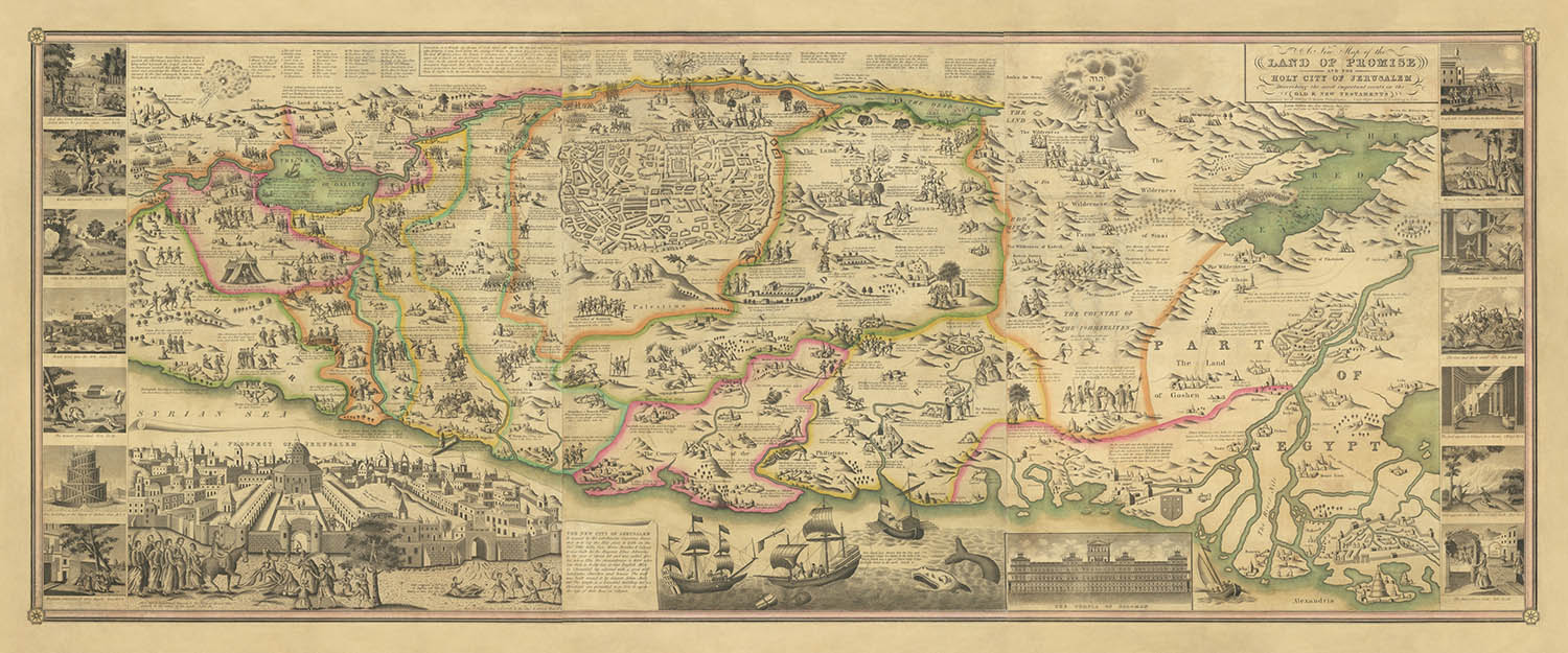
Entra nella geografia sacra dell'antichità con "Una Nuova Mappa della Terra della Promessa e della Città Santa di Gerusalemme", un capolavoro di...
Continua a leggereEntra nella geografia sacra dell'antichità con "Una Nuova Mappa della Terra della Promessa e della Città Santa di Gerusalemme", un capolavoro di arte cartografica e narrazione biblica, incisa da D. Haines nel 1828. Questa rara mappa murale americana, con solo un pugno di esempi istituzionali noti, offre una prospettiva a volo d'uccello della Terra Santa, estendendosi dalle storiche rive del Nilo e del Mar Rosso alle antiche città di Damasco e Sidone. Al suo centro si trova Gerusalemme, rappresentata con meticolosità e celebrata come l'epicentro spirituale delle fedi abramitiche. Il design della mappa non è semplicemente geografico: è un arazzo visivo che intreccia la storia sacra con il paesaggio stesso.
Ciò che distingue questa mappa è la sua narrativa riccamente illustrata, che dà vita agli eventi più cruciali dell'Antico e del Nuovo Testamento. Centinaia di piccole vignette, ciascuna incisa con cura, ritraggono momenti come l'Esodo, l'attraversamento del Mar Rosso e Mosè che riceve i Dieci Comandamenti sul Monte Sinai. Queste scene non sono semplici decorazioni; sono punti di riferimento storici, che invitano lo spettatore a tracciare i viaggi, le lotte e i trionfi delle figure bibliche attraverso il territorio. L'approccio pittorico della mappa la trasforma in un artefatto unico: sia un'opera d'arte che uno strumento didattico per comprendere il mondo antico.
La linea genealogica cartografica della mappa è altrettanto notevole. Il suo formato e il linguaggio visivo sono direttamente ispirati dalle tradizioni olandesi e inglesi del XVII secolo, in particolare dal prototipo del 1641 di van Doetechum e dal celebre piano di Gerusalemme di Claes Jansz Visscher. L'edizione di Haines rappresenta il culmine di quasi due secoli di creazione di mappe europee e americane, reinterpretata per un nuovo pubblico nella Filadelfia dei primi anni del 1800. Questa fusione di artigianato del Vecchio Mondo e ambizione del Nuovo Mondo è evidente in ogni dettaglio, dalle ornate viste in prospettiva del Tempio di Salomone al panoramico "Prospetto di Gerusalemme" che corona la composizione.
Oltre al suo fascino estetico, la mappa è un documento storico notevole, che cattura un momento in cui la ricerca biblica, la devozione religiosa e l'arte dell'incisione si sono fuse nella cultura della stampa americana. La sua rarità, attestata dai pochi esempi sopravvissuti, parla del suo valore sia come oggetto da collezione che come testimonianza della duratura fascinazione per la Terra Santa. Per storici, collezionisti e intenditori di cartografia, questa mappa offre una finestra senza pari sui modi in cui fede, storia e geografia sono state intrecciate nel corso dei secoli.
La copertura della mappa è impressionantemente completa, comprendendo luoghi iconici come Betlemme, Gerico, Hebron, Nazareth e il Lago di Galilea, così come le vaste distese d'Egitto e la Penisola del Sinai. Le principali rotte bibliche e accampamenti sono tracciati con precisione, mentre città, fortezze e punti di riferimento sono resi in una evocativa prospettiva a volo d'uccello. Ogni elemento invita all'esplorazione, sia che tu stia ripercorrendo i passi dei profeti antichi o semplicemente ammirando l'arte di un'epoca passata. Questa mappa non è solo un banchetto visivo, ma anche un profondo artefatto storico: un invito a viaggiare attraverso la Terra della Promessa come era immaginata dai cartografi e dai credenti del passato.
Luoghi su questa mappa
- Gerusalemme
- Betlemme
- Gerico
- Hebron
- Damasco
- Sidone
- Il Cairo
- La Mecca
- Monte Sinai
- Fiume Nilo
- Mar Rosso
- Mar Morto
- Fiume Giordano
- Gaza
- Joppa (Jaffa)
- Nazareth
- Mar di Galilea
- Egitto
- Pennino del Sinai
- Samaria
Caratteristiche e luoghi notevoli
- Vista a volo d'uccello prominente della città di Gerusalemme
- Piano dettagliato di Gerusalemme, numerato con luoghi chiave
- Rappresentazione in insetto del Tempio di Salomone
- Vista panoramica di "Una Prospettiva di Gerusalemme"
- Illustrazioni che rappresentano eventi biblici come:
- l'uscita dall'Egitto
- Attraversamento del Mar Rosso
- Mose che riceve i Dieci Comandamenti sul Monte Sinai
- Gli accampamenti degli Israeliti durante il loro viaggio
- Rappresentazioni di battaglie e eventi biblici significativi nella regione
- Numerosi piccoli vignette che illustrano scene dalle narrazioni dell'Antico Testamento
- Percorsi e sentieri chiaramente etichettati rilevanti per le storie bibliche
- Rappresentazioni di città, villaggi e fortezze in uno stile pittorico a volo d'uccello
- Delta del Nilo e costa egiziana mostrati in modo prominente
- Pennino del Sinai chiaramente rappresentato con il Monte Sinai etichettato
- Il fiume Giordano e il Mar Morto chiaramente etichettati e illustrati
- Illustrazioni di luoghi biblici significativi, come Betlemme, Gerico e Hebron
Contesto storico e di design
- Rara mappa murale americana che rappresenta la Terra Santa e l'Egitto, con solo un pugno di esempi istituzionali conosciuti
- Incisa da D. Haines nel 1828, che lavorava per noti editori di Filadelfia J.H. Young e S. Augustus Mitchell
- Derivata da una lunga tradizione di mappe pittoriche risalente al cartografo olandese del XVII secolo van Doetechum, con edizioni inglesi successive nel XVIII secolo
- Ricca di illustrazioni con vignette pittoriche, che danno vita a eventi cruciali dell'Antico e del Nuovo Testamento
- Presenta viste dettagliate in insetto di Gerusalemme e del Tempio di Salomone, ispirate alla mappa di Gerusalemme del XVII secolo di Claes Jansz Visscher
- Rappresenta il culmine di quasi due secoli di creazione di mappe europee e americane, reinterpretata per un nuovo pubblico nella Filadelfia del primo XIX secolo
- Storicamente informativa, illustra eventi e storie bibliche con precisione geografica
- Unisce l'artigianato del Vecchio Mondo e l'ambizione del Nuovo Mondo nel suo design e nella sua esecuzione
Si prega di controllare attentamente le immagini per assicurarsi che una specifica città o luogo sia mostrato su questa mappa. È possibile anche contattarci e chiedere di controllare la mappa per te.
Questa è una mappa molto grande che deve essere ordinata in grande formato, in modo da poter facilmente distinguere tutti i dettagli.
Questa mappa appare fantastica a dimensioni fino a 100 pollici (250 cm). Se stai cercando una mappa più grande, ti preghiamo di contattarci.
Il modello nelle immagini dell'annuncio tiene la versione indefinita di questa mappa.
La quinta immagine dell'annuncio mostra un esempio del mio servizio di personalizzazione della mappa.
Se stai cercando qualcosa di leggermente diverso, dai un'occhiata alla mia collezione delle migliori mappe antiche per vedere se qualcosa attira la tua attenzione.
Per favore contattami per verificare se una certa posizione, punto di riferimento o caratteristica è mostrata su questa mappa.
Questo sarebbe un meraviglioso regalo di compleanno, Natale, Festa del Papà, partenza dal lavoro, anniversario o regalo per una nuova casa per qualcuno delle aree coperte da questa mappa.
Questa mappa è disponibile come stampa giclée su carta opaca archiviata senza acidi, oppure puoi acquistarla incorniciata. La cornice è una bella e semplice cornice nera che si adatta alla maggior parte delle estetiche. Ti preghiamo di contattarci se desideri un colore o un materiale di cornice diverso. Le mie cornici sono rivestite con acrilico super chiaro di grado museo (perspex/acrylite), che è significativamente meno riflettente del vetro, più sicuro e arriverà sempre in perfette condizioni.
This map is also available as a float framed canvas, sometimes known as a shadow gap framed canvas or canvas floater. The map is printed on artist's cotton canvas and then stretched over a handmade box frame. We then "float" the canvas inside a wooden frame, which is available in a range of colours (black, dark brown, oak, antique gold and white). This is a wonderful way to present a map without glazing in front. See some examples of float framed canvas maps and explore the differences between my different finishes.
For something truly unique, this map is also available in "Unique 3D", our trademarked process that dramatically transforms the map so that it has a wonderful sense of depth. We combine the original map with detailed topography and elevation data, so that mountains and the terrain really "pop". For more info and examples of 3D maps, check my Unique 3D page.
Entra nella geografia sacra dell'antichità con "Una Nuova Mappa della Terra della Promessa e della Città Santa di Gerusalemme", un capolavoro di arte cartografica e narrazione biblica, incisa da D. Haines nel 1828. Questa rara mappa murale americana, con solo un pugno di esempi istituzionali noti, offre una prospettiva a volo d'uccello della Terra Santa, estendendosi dalle storiche rive del Nilo e del Mar Rosso alle antiche città di Damasco e Sidone. Al suo centro si trova Gerusalemme, rappresentata con meticolosità e celebrata come l'epicentro spirituale delle fedi abramitiche. Il design della mappa non è semplicemente geografico: è un arazzo visivo che intreccia la storia sacra con il paesaggio stesso.
Ciò che distingue questa mappa è la sua narrativa riccamente illustrata, che dà vita agli eventi più cruciali dell'Antico e del Nuovo Testamento. Centinaia di piccole vignette, ciascuna incisa con cura, ritraggono momenti come l'Esodo, l'attraversamento del Mar Rosso e Mosè che riceve i Dieci Comandamenti sul Monte Sinai. Queste scene non sono semplici decorazioni; sono punti di riferimento storici, che invitano lo spettatore a tracciare i viaggi, le lotte e i trionfi delle figure bibliche attraverso il territorio. L'approccio pittorico della mappa la trasforma in un artefatto unico: sia un'opera d'arte che uno strumento didattico per comprendere il mondo antico.
La linea genealogica cartografica della mappa è altrettanto notevole. Il suo formato e il linguaggio visivo sono direttamente ispirati dalle tradizioni olandesi e inglesi del XVII secolo, in particolare dal prototipo del 1641 di van Doetechum e dal celebre piano di Gerusalemme di Claes Jansz Visscher. L'edizione di Haines rappresenta il culmine di quasi due secoli di creazione di mappe europee e americane, reinterpretata per un nuovo pubblico nella Filadelfia dei primi anni del 1800. Questa fusione di artigianato del Vecchio Mondo e ambizione del Nuovo Mondo è evidente in ogni dettaglio, dalle ornate viste in prospettiva del Tempio di Salomone al panoramico "Prospetto di Gerusalemme" che corona la composizione.
Oltre al suo fascino estetico, la mappa è un documento storico notevole, che cattura un momento in cui la ricerca biblica, la devozione religiosa e l'arte dell'incisione si sono fuse nella cultura della stampa americana. La sua rarità, attestata dai pochi esempi sopravvissuti, parla del suo valore sia come oggetto da collezione che come testimonianza della duratura fascinazione per la Terra Santa. Per storici, collezionisti e intenditori di cartografia, questa mappa offre una finestra senza pari sui modi in cui fede, storia e geografia sono state intrecciate nel corso dei secoli.
La copertura della mappa è impressionantemente completa, comprendendo luoghi iconici come Betlemme, Gerico, Hebron, Nazareth e il Lago di Galilea, così come le vaste distese d'Egitto e la Penisola del Sinai. Le principali rotte bibliche e accampamenti sono tracciati con precisione, mentre città, fortezze e punti di riferimento sono resi in una evocativa prospettiva a volo d'uccello. Ogni elemento invita all'esplorazione, sia che tu stia ripercorrendo i passi dei profeti antichi o semplicemente ammirando l'arte di un'epoca passata. Questa mappa non è solo un banchetto visivo, ma anche un profondo artefatto storico: un invito a viaggiare attraverso la Terra della Promessa come era immaginata dai cartografi e dai credenti del passato.
Luoghi su questa mappa
- Gerusalemme
- Betlemme
- Gerico
- Hebron
- Damasco
- Sidone
- Il Cairo
- La Mecca
- Monte Sinai
- Fiume Nilo
- Mar Rosso
- Mar Morto
- Fiume Giordano
- Gaza
- Joppa (Jaffa)
- Nazareth
- Mar di Galilea
- Egitto
- Pennino del Sinai
- Samaria
Caratteristiche e luoghi notevoli
- Vista a volo d'uccello prominente della città di Gerusalemme
- Piano dettagliato di Gerusalemme, numerato con luoghi chiave
- Rappresentazione in insetto del Tempio di Salomone
- Vista panoramica di "Una Prospettiva di Gerusalemme"
- Illustrazioni che rappresentano eventi biblici come:
- l'uscita dall'Egitto
- Attraversamento del Mar Rosso
- Mose che riceve i Dieci Comandamenti sul Monte Sinai
- Gli accampamenti degli Israeliti durante il loro viaggio
- Rappresentazioni di battaglie e eventi biblici significativi nella regione
- Numerosi piccoli vignette che illustrano scene dalle narrazioni dell'Antico Testamento
- Percorsi e sentieri chiaramente etichettati rilevanti per le storie bibliche
- Rappresentazioni di città, villaggi e fortezze in uno stile pittorico a volo d'uccello
- Delta del Nilo e costa egiziana mostrati in modo prominente
- Pennino del Sinai chiaramente rappresentato con il Monte Sinai etichettato
- Il fiume Giordano e il Mar Morto chiaramente etichettati e illustrati
- Illustrazioni di luoghi biblici significativi, come Betlemme, Gerico e Hebron
Contesto storico e di design
- Rara mappa murale americana che rappresenta la Terra Santa e l'Egitto, con solo un pugno di esempi istituzionali conosciuti
- Incisa da D. Haines nel 1828, che lavorava per noti editori di Filadelfia J.H. Young e S. Augustus Mitchell
- Derivata da una lunga tradizione di mappe pittoriche risalente al cartografo olandese del XVII secolo van Doetechum, con edizioni inglesi successive nel XVIII secolo
- Ricca di illustrazioni con vignette pittoriche, che danno vita a eventi cruciali dell'Antico e del Nuovo Testamento
- Presenta viste dettagliate in insetto di Gerusalemme e del Tempio di Salomone, ispirate alla mappa di Gerusalemme del XVII secolo di Claes Jansz Visscher
- Rappresenta il culmine di quasi due secoli di creazione di mappe europee e americane, reinterpretata per un nuovo pubblico nella Filadelfia del primo XIX secolo
- Storicamente informativa, illustra eventi e storie bibliche con precisione geografica
- Unisce l'artigianato del Vecchio Mondo e l'ambizione del Nuovo Mondo nel suo design e nella sua esecuzione
Si prega di controllare attentamente le immagini per assicurarsi che una specifica città o luogo sia mostrato su questa mappa. È possibile anche contattarci e chiedere di controllare la mappa per te.
Questa è una mappa molto grande che deve essere ordinata in grande formato, in modo da poter facilmente distinguere tutti i dettagli.
Questa mappa appare fantastica a dimensioni fino a 100 pollici (250 cm). Se stai cercando una mappa più grande, ti preghiamo di contattarci.
Il modello nelle immagini dell'annuncio tiene la versione indefinita di questa mappa.
La quinta immagine dell'annuncio mostra un esempio del mio servizio di personalizzazione della mappa.
Se stai cercando qualcosa di leggermente diverso, dai un'occhiata alla mia collezione delle migliori mappe antiche per vedere se qualcosa attira la tua attenzione.
Per favore contattami per verificare se una certa posizione, punto di riferimento o caratteristica è mostrata su questa mappa.
Questo sarebbe un meraviglioso regalo di compleanno, Natale, Festa del Papà, partenza dal lavoro, anniversario o regalo per una nuova casa per qualcuno delle aree coperte da questa mappa.
Questa mappa è disponibile come stampa giclée su carta opaca archiviata senza acidi, oppure puoi acquistarla incorniciata. La cornice è una bella e semplice cornice nera che si adatta alla maggior parte delle estetiche. Ti preghiamo di contattarci se desideri un colore o un materiale di cornice diverso. Le mie cornici sono rivestite con acrilico super chiaro di grado museo (perspex/acrylite), che è significativamente meno riflettente del vetro, più sicuro e arriverà sempre in perfette condizioni.
This map is also available as a float framed canvas, sometimes known as a shadow gap framed canvas or canvas floater. The map is printed on artist's cotton canvas and then stretched over a handmade box frame. We then "float" the canvas inside a wooden frame, which is available in a range of colours (black, dark brown, oak, antique gold and white). This is a wonderful way to present a map without glazing in front. See some examples of float framed canvas maps and explore the differences between my different finishes.
For something truly unique, this map is also available in "Unique 3D", our trademarked process that dramatically transforms the map so that it has a wonderful sense of depth. We combine the original map with detailed topography and elevation data, so that mountains and the terrain really "pop". For more info and examples of 3D maps, check my Unique 3D page.
Many of our maps and art prints are chosen as thoughtful gifts for homes, offices, studies and meaningful places.
Choose a framed option for the easiest ready-to-hang gift, or choose an unframed print if the recipient may prefer to select their own frame.
We make orders locally in 23 countries around the world, so gifts can often be produced close to the recipient. This helps them arrive faster, travel more safely, and avoid customs or import duty surprises.
- We can deliver directly to the recipient
- Framed pieces arrive ready to hang
- Unframed prints are carefully packed in a strong protective tube
- Almost every order is made locally, for faster, safer gifting
- 90-day returns give the recipient time to decide
If you are not sure what to choose, please contact us. We can help you pick the right map, size, finish or delivery option.
Most orders are made locally and delivered in around 2–3 working days, depending on the product, size and destination.
We print and frame maps and artwork in 23 countries around the world, so your order is usually made close to you or your recipient. That means faster delivery, less time in transit, and no customs or import duty surprises.
Personalised and customised pieces usually take an extra 1–2 working days, because we prepare your design and send it to you for approval before printing.
Very large framed orders can take a little longer, as they need extra care in production and delivery.
Every order is carefully packaged: unframed prints are sent in a strong protective tube, while framed pieces are securely packed with protective materials around the frame.
If you need your order by a particular date, please contact us before ordering. We’ll check the best production route and delivery option for your location.
Express delivery is available at checkout for most countries. Next-day delivery is available in the UK, US, Singapore and the UAE.
Your order is covered by our 90-day returns policy and 10-year guarantee.
Our standard frame is a gallery-style black ash hardwood frame, with a simple, modern look. It is approximately 20mm (0.8in) wide. You can also view some lovely customer photos of framed maps and art.
We use super-clear acrylic glazing, also known as Perspex or Acrylite, instead of traditional glass. It is lighter, safer, and has lower reflectivity, giving the artwork a clearer, cleaner appearance.
Six standard frame colours are available at no extra cost: black, dark brown, dark grey, oak, white, and antique gold. Custom framing and mounting/matting is also available for customers looking for something more specific.
Most maps, art prints, and illustrations are also available as a framed canvas. We use matte cotton canvas, stretch it over a sustainably sourced wooden box frame, and then float the piece within a wooden outer frame. The finished result is beautifully presented, with no glazing between you and the artwork.
All frames are supplied ready to hang, with either string or brackets fitted to the back. Very large frames will include heavy-duty hanging plates and/or a mounting baton. If you have any questions, please get in touch.
We can also supply old maps and artwork on canvas, foam board, cotton rag, and other materials.
If you would prefer to frame your map or artwork yourself, please read our size guide before ordering.
My maps are extremely high quality reproductions of original maps.
I source original, rare maps from libraries, auction houses and private collections around the world, restore them at my London workshop, and then use specialist giclée inks and printers to create beautiful maps that look even better than the original.
My maps are printed on acid-free archival matte (not glossy) paper that feels very high quality and almost like card. In technical terms the paper weight/thickness is 10mil/200gsm. It's perfect for framing.
I print with Epson ultrachrome giclée UV fade resistant pigment inks - some of the best inks you can find.
I can also make maps on canvas, cotton rag and other exotic materials.
Learn more about The Unique Maps Co.
Map personalisation
If you're looking for the perfect anniversary or housewarming gift, I can personalise your map to make it truly unique. For example, I can add a short message, or highlight an important location, or add your family's coat of arms.
The options are almost infinite. Please see my map personalisation page for some wonderful examples of what's possible.
To order a personalised map, select "personalise your map" before adding it to your basket.
Get in touch if you're looking for more complex customisations and personalisations.
Map ageing
I have been asked hundreds of times over the years by customers if they could buy a map that looks even older.
Well, now you can, by selecting Aged before you add a map to your basket.
All the product photos you see on this page show the map in its Original form. This is what the map looks like today.
If you select Aged, I will age your map by hand, using a special and unique process developed through years of studying old maps, talking to researchers to understand the chemistry of aging paper, and of course... lots of practice!
If you're unsure, stick to the Original colour of the map. If you want something a bit darker and older looking, go for Aged.
Se non sei soddisfatto del tuo ordine per qualsiasi motivo, contattami per un rimborso senza problemi. Si prega di consultare la nostra politica di reso e rimborso per ulteriori informazioni.
Sono molto sicuro che ti piacerà la tua mappa restaurata o la stampa d'arte. Lo faccio dal 1984. Sono un venditore Etsy a 5 stelle. Ho venduto decine di migliaia di mappe e stampe d'arte e ho oltre 5.000 recensioni reali a 5 stelle.
Utilizzo un processo unico per restaurare mappe e opere d'arte che richiede molto tempo e lavoro. Trovare le mappe e le illustrazioni originali può richiedere mesi. Utilizzo tecnologia all'avanguardia e incredibilmente costosa per scannerizzare e restaurarle. Di conseguenza, garantisco che le mie mappe e stampe d'arte siano superiori alle altre - ecco perché posso offrire un rimborso senza problemi.
Quasi tutte le mie mappe e stampe d'arte sembrano fantastiche a grandi dimensioni (200 cm, 6,5 piedi+) e posso anche incorniciarle e consegnarle a te, tramite un corriere speciale per oggetti di grandi dimensioni. Contattami per discutere delle tue esigenze specifiche.
Or try searching for something!


