- Handmade locally. No import duty or tax
- FREE worldwide delivery
- 90-day returns & 5-year product guarantee
- Questions? WhatsApp me any time
Own a piece of history
7,000+ 5 star reviews


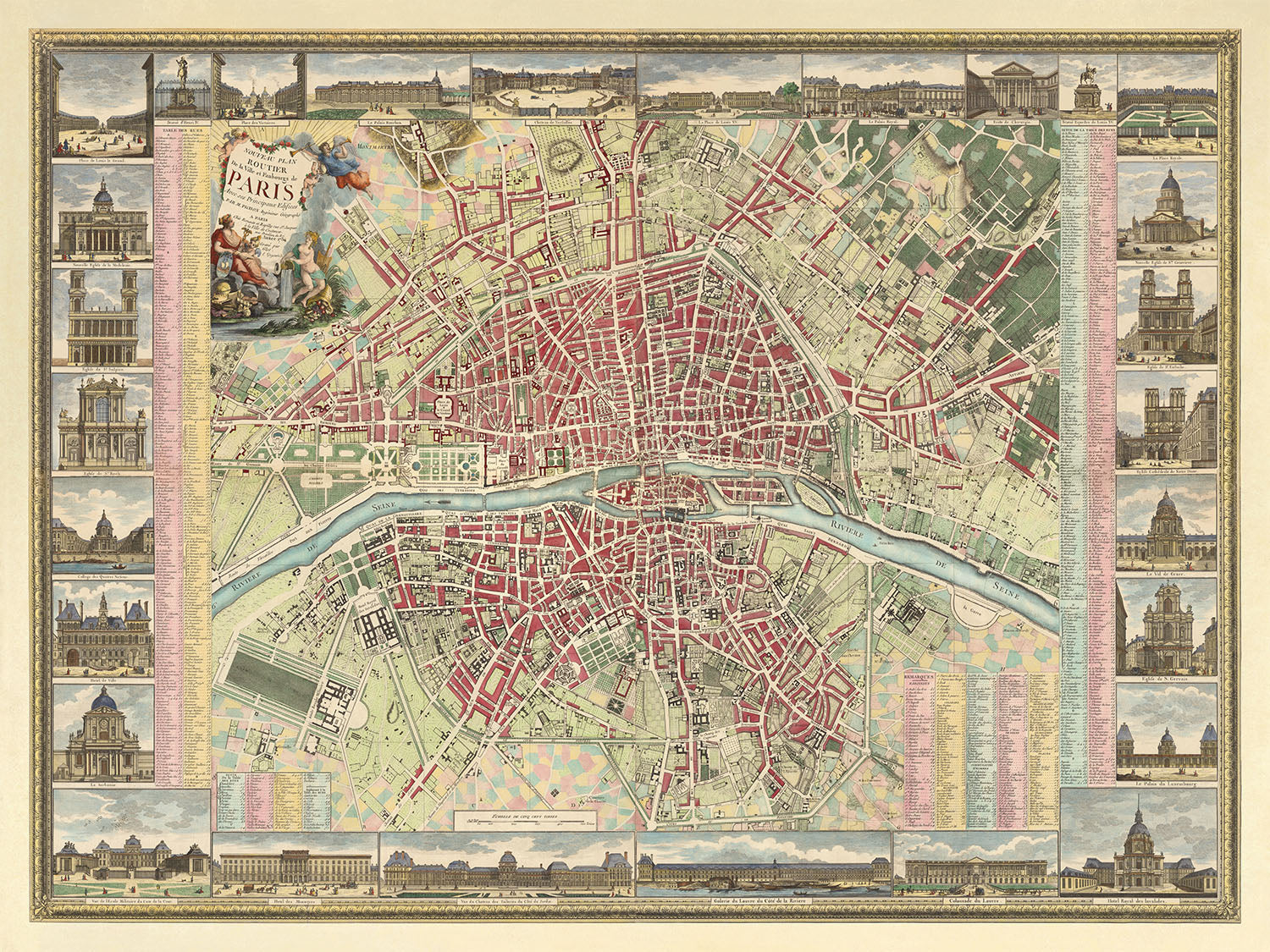
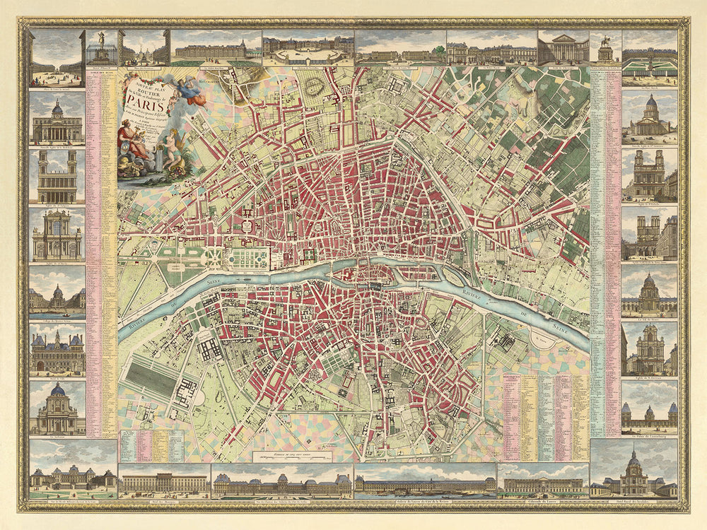
Embark on a journey through time with the exquisite "Nouveau Plan Routier de la Ville et Faubourgs de Paris," a masterpiece crafted in 1784 by the esteemed mapmaker duo Esnauts & Rapilly, with the artistic contributions of Michel Glot and M. Pichon. This map is not merely a navigational tool but a window into the soul of Paris before the tumultuous events of the French Revolution. Its detailed portrayal of the city's streets, parishes, and notable edifices, framed by a stunning floral border and an allegorical title cartouche, captures the essence of an era when Paris was the heart of enlightenment and culture. The map's intricate design and style, featuring angels and symbols of the arts and sciences, invite admirers to explore the rich tapestry of Parisian life and its intellectual heritage.
The map meticulously divides Paris into 12 arrondissements, further segmented into 48 quartiers, offering a unique glimpse into the urban layout before modern transformations. It showcases significant neighborhoods such as the Faubourg Saint-Germain and Faubourg Saint-Honoré, areas synonymous with aristocracy and luxury. These districts, along with the depicted boulevards and streets like Boulevard Bonne Nouvelle and Rue de Rivoli, were the lifelines of the city, pulsating with the rhythm of Parisian society. The inclusion of landmarks such as the Louvre and Notre Dame Cathedral, alongside the less monumental but equally significant streets, creates a vivid portrayal of 18th-century Paris, making this map a treasure for both historians and aficionados of urban cartography.
Rivers and waterways have always been the veins through which the lifeblood of a city flows, and the "Nouveau Plan Routier" emphasizes this with its centered depiction of the Seine. This focus not only highlights the river's importance in Parisian geography and commerce but also frames the city's most picturesque vistas and gatherings spots of the time. The map's attention to detail extends to the portrayal of bridges like Pont Neuf and Pont Royal, crucial for their role in connecting the city's diverse quarters and facilitating the vibrant interchange of goods and ideas.
Amidst the urban landscape, the map does not forget the green lungs of Paris. The inclusion of large parks such as the Bois de Boulogne and the Bois de Vincennes, along with the Lac de la Muette, offers a breath of fresh air. These areas, represented with care and precision, were and continue to be essential escapes for Parisians from the hustle and bustle of city life. Their depiction on the map serves as a reminder of the balance between urban development and the need for natural spaces, a concept as relevant today as it was in the 18th century.
Finally, the "Nouveau Plan Routier" is a testament to the collaborative spirit of its creators, Esnauts & Rapilly, Michel Glot, and M. Pichon. Their combined efforts have produced not just a map but a piece of art that celebrates Paris's architectural marvels and the vibrancy of its streets and neighborhoods. The detailed illustrations of landmarks and the decorative elements around the map's border enrich the viewer's experience, making it a piece worthy of admiration and study. This map is more than a collector's item; it is a homage to the enduring allure of Paris, a city that has captivated hearts and minds across centuries.
Streets and roads on this map
- Boulevard Bonne Nouvelle
- Boulevard des Capucines
- Boulevard de la Madeleine
- Boulevard du Temple
- Faubourg Saint-Antoine
- Faubourg Saint-Denis
- Faubourg Saint-Germain
- Faubourg Saint-Honoré
- Pont au Change
- Pont Louis XVI
- Pont Neuf
- Pont Royal
- Quai de Gesvres
- Quai des Tuileries
- Rue de Castiglione
- Rue de Rivoli
Notable Features & Landmarks
- Inset maps of various Faubourgs including Saint Germain, Saint Antoine, and others.
- Illustrations of the title cartouche in the top left corner featuring an allegorical scene of the Seine River and the city of Paris.
- Decorative border featuring various landmarks and scenes from Parisian life.
- The map is divided into 12 arrondissements, further divided into 48 quartiers.
- Features many of Paris's most famous landmarks, including the Louvre, the Tuileries Gardens, the Palais Royal, and others.
- The map features the Lac de la Muette in the Bois de Boulogne.
- Large parks like the Bois de Boulogne, the Bois de Vincennes, and the Parc de Monceau are featured.
Historical and design context
- Title: Nouveau Plan Routier de la Ville et Faubourgs de Paris
- Date: 1784
- Mapmaker/Publisher: Esnauts & Rapilly; Michel Glot (engraver); M. Pichon (illustrator)
- Coverage: Paris, France
- Themes: City street map; shows streets, parishes, colleges, hospitals, important buildings, landmarks, major squares and other points of interest
- Design/Style: Floral border; title cartouche showing angels and an allegory of Paris with the symbols of the arts and sciences; 28 inset illustrations of places and landmarks
- Historical significance: Depicts Paris prior to the French Revolution
Please double check the images to make sure that a specific town or place is shown on this map. You can also get in touch and ask us to check the map for you.
This map looks great at every size, but I always recommend going for a larger size if you have space. That way you can easily make out all of the details.
This map looks amazing at sizes all the way up to 100in (250cm). If you are looking for a larger map, please get in touch.
Please note: the labels on this map are hard to read if you order a map that is 20in (50cm) or smaller. The map is still very attractive, but if you would like to read the map easily, please buy a larger size.
The model in the listing images is holding the 18x24in (45x60cm) version of this map.
The fifth listing image shows an example of my map personalisation service.
If you’re looking for something slightly different, check out my collection of the best old maps to see if something else catches your eye.
Please contact me to check if a certain location, landmark or feature is shown on this map.
This would make a wonderful birthday, Christmas, Father's Day, work leaving, anniversary or housewarming gift for someone from the areas covered by this map.
This map is available as a giclée print on acid free archival matte paper, or you can buy it framed. The frame is a nice, simple black frame that suits most aesthetics. Please get in touch if you'd like a different frame colour or material. My frames are glazed with super-clear museum-grade acrylic (perspex/acrylite), which is significantly less reflective than glass, safer, and will always arrive in perfect condition.
This map is also available as a float framed canvas, sometimes known as a shadow gap framed canvas or canvas floater. The map is printed on artist's cotton canvas and then stretched over a handmade box frame. We then "float" the canvas inside a wooden frame, which is available in a range of colours (black, dark brown, oak, antique gold and white). This is a wonderful way to present a map without glazing in front. See some examples of float framed canvas maps and explore the differences between my different finishes.
For something truly unique, this map is also available in "Unique 3D", our trademarked process that dramatically transforms the map so that it has a wonderful sense of depth. We combine the original map with detailed topography and elevation data, so that mountains and the terrain really "pop". For more info and examples of 3D maps, check my Unique 3D page.
For most orders, delivery time is about 3 working days. Personalised and customised products take longer, as I have to do the personalisation and send it to you for approval, which usually takes 1 or 2 days.
Please note that very large framed orders usually take longer to make and deliver.
If you need your order to arrive by a certain date, please contact me before you order so that we can find the best way of making sure you get your order in time.
I print and frame maps and artwork in 23 countries around the world. This means your order will be made locally, which cuts down on delivery time and ensures that it won't be damaged during delivery. You'll never pay customs or import duty, and we'll put less CO2 into the air.
All of my maps and art prints are well packaged and sent in a rugged tube if unframed, or surrounded by foam if framed.
I try to send out all orders within 1 or 2 days of receiving your order, though some products (like face masks, mugs and tote bags) can take longer to make.
If you select Express Delivery at checkout your order we will prioritise your order and send it out by 1-day courier (Fedex, DHL, UPS, Parcelforce).
Next Day delivery is also available in some countries (US, UK, Singapore, UAE) but please try to order early in the day so that we can get it sent out on time.
My standard frame is a gallery style black ash hardwood frame. It is simple and quite modern looking. My standard frame is around 20mm (0.8in) wide.
I use super-clear acrylic (perspex/acrylite) for the frame glass. It's lighter and safer than glass - and it looks better, as the reflectivity is lower.
Six standard frame colours are available for free (black, dark brown, dark grey, oak, white and antique gold). Custom framing and mounting/matting is available if you're looking for something else.
Most maps, art and illustrations are also available as a framed canvas. We use matte (not shiny) cotton canvas, stretch it over a sustainably sourced box wood frame, and then 'float' the piece within a wood frame. The end result is quite beautiful, and there's no glazing to get in the way.
All frames are provided "ready to hang", with either a string or brackets on the back. Very large frames will have heavy duty hanging plates and/or a mounting baton. If you have any questions, please get in touch.
See some examples of my framed maps and framed canvas maps.
Alternatively, I can also supply old maps and artwork on canvas, foam board, cotton rag and other materials.
If you want to frame your map or artwork yourself, please read my size guide first.
My maps are extremely high quality reproductions of original maps.
I source original, rare maps from libraries, auction houses and private collections around the world, restore them at my London workshop, and then use specialist giclée inks and printers to create beautiful maps that look even better than the original.
My maps are printed on acid-free archival matte (not glossy) paper that feels very high quality and almost like card. In technical terms the paper weight/thickness is 10mil/200gsm. It's perfect for framing.
I print with Epson ultrachrome giclée UV fade resistant pigment inks - some of the best inks you can find.
I can also make maps on canvas, cotton rag and other exotic materials.
Learn more about The Unique Maps Co.
Map personalisation
If you're looking for the perfect anniversary or housewarming gift, I can personalise your map to make it truly unique. For example, I can add a short message, or highlight an important location, or add your family's coat of arms.
The options are almost infinite. Please see my map personalisation page for some wonderful examples of what's possible.
To order a personalised map, select "personalise your map" before adding it to your basket.
Get in touch if you're looking for more complex customisations and personalisations.
Map ageing
I have been asked hundreds of times over the years by customers if they could buy a map that looks even older.
Well, now you can, by selecting Aged before you add a map to your basket.
All the product photos you see on this page show the map in its Original form. This is what the map looks like today.
If you select Aged, I will age your map by hand, using a special and unique process developed through years of studying old maps, talking to researchers to understand the chemistry of aging paper, and of course... lots of practice!
If you're unsure, stick to the Original colour of the map. If you want something a bit darker and older looking, go for Aged.
If you are not happy with your order for any reason, contact me and I'll get it fixed ASAP, free of charge. Please see my returns and refund policy for more information.
I am very confident you will like your restored map or art print. I have been doing this since 1984. I'm a 5-star Etsy seller. I have sold tens of thousands of maps and art prints and have over 5,000 real 5-star reviews. My work has been featured in interior design magazines, on the BBC, and on the walls of dozens of 5-star hotels.
I use a unique process to restore maps and artwork that is massively time consuming and labour intensive. Hunting down the original maps and illustrations can take months. I use state of the art and eye-wateringly expensive technology to scan and restore them. As a result, I guarantee my maps and art prints are a cut above the rest. I stand by my products and will always make sure you're 100% happy with what you receive.
Almost all of my maps and art prints look amazing at large sizes (200cm, 6.5ft+) and I can frame and deliver them to you as well, via special oversized courier. Contact me to discuss your specific needs.
Or try searching for something!


