


Custom Map of London by Edward Stanford, 1862: Design & Make Your Own Old Map
 Designed in London Made in Canada
Designed in London • Made in Canada
Designed in London Made in Canada
Designed in London • Made in Canada

Created from real antique maps, restored and customised to order. Read the story behind this map
See the image gallery for what each map looks like.
Contact me if you need help with your order.


Gift message & custom finish

If you want to add a gift message, or a finish (jigsaw, aluminium board, etc.) that is not available here, please request it in the "order note" when you check out.
Every order is custom made, so if you need the size adjusted slightly, or printed on an unusual material, just let us know. We've done thousands of custom orders over the years, so there's (almost) nothing we can't manage.
You can also contact us before you order, if you prefer!

- Made locally for fast, safe delivery
- No import duty or hidden fees
- Need advice? Call us or message on WhatsApp
Own a piece of history
8,000+ five-star reviews


Behold! You can finally make your own custom map of London by Edward Stanford. You can choose between three versions of the...
Continue readingBehold! You can finally make your own custom map of London by Edward Stanford.
You can choose between three versions of the Stanford map of London: The oldest monochrome map from 1862; a monochrome version with blue Thames from 1862; or a fully handcoloured one from 1891. The zoomable map will not change when you select a coloured map, but we will save your preference and make sure you get your preferred map style.
Simply drag and zoom the map, and when you're happy with it add the map to your basket. You can use the magnifying glass to search for a specific street, postcode or landmark.
I will then create the exact same map and send it to you. The finished map will look just like a real Stanford map of London with the frame, title and legend in place. See the 'example images' - this is exactly what your map will look like.
The fifth listing image shows an example of my map personalisation service.
Please make sure you select whether you want the map to be landscape (wider), portrait (taller) or square (square).
I will send you a draft image of your map before I print it. You can also leave a note on your shopping basket if you want to make doubly sure that I've got the right area on the map.
If you want your map further personalised with a message inscribed on the map, please select the 'personalisation' option. If you want a different kind of personalisation (like marking your house with a certain colour) please get in touch.
These custom-made maps are perfect as housewarming gifts, or for your own office or living room wall if you live in London.
You can order the map itself, or you can order a framed version. The frame is a nice, simple black frame that really makes my maps pop out when on the wall. Please get in touch if you'd like a different frame. I use super-clear acrylic (perspex/acrylite) - it's less reflective than glass and better for transport.
For a limited time these custom maps are the same price as my other maps - once I've done a few, the price will go up.
About the map
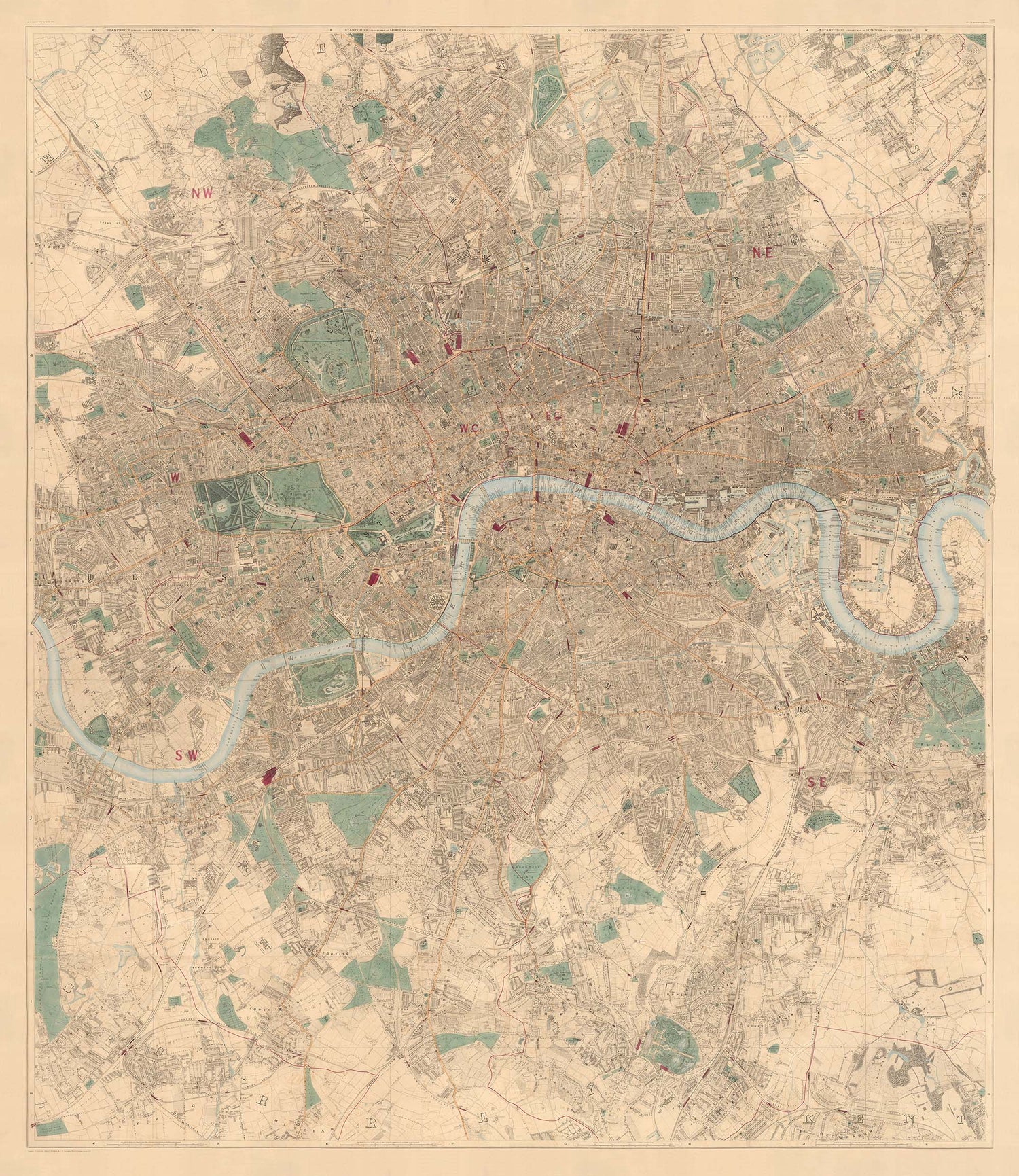
Edward Stanford's Library Map of London is widely considered to be the greatest map of London ever made. Compiled in the 1850s and 60s, it shows the heart of the British Empire at the peak of Victorian Britain.
An almost perfect version of this map has been sourced and lovingly restored by the Unique Maps Co. This is the best version of this map that you can buy anywhere.
Originally printed in 24 sheets, this is the most detailed old London map you can find. Almost every single dwelling in London is drawn on this map - and considering there were around 3 million people living in London in the 1860s, that's a lot of dwellings.
By the 1860s, almost all of London's famous landmarks already exist. The parks, the palaces, the museums, St Paul's, the royal parks - they're all here. Perhaps the main one that hasn't been built yet is the Royal Albert Hall which would be opened about 10 years later.
If you are looking for super large versions of this map (I can print and frame it up to 10 meters/33ft wide), please see this product instead. I can also make some lovely wallpaper with this map.
My large maps are perfect for hotels, pubs, bars and offices - but if you have a large space at home, then they would look amazing there as well!
Please get in touch with me before you order so that we can discuss what you're looking for and make sure that the map you buy will look perfect.
This map is also available as a float framed canvas, sometimes known as a shadow gap framed canvas or canvas floater. The map is printed on artist's cotton canvas and then stretched over a handmade box frame. We then "float" the canvas inside a wooden frame, which is available in a range of colours (black, dark brown, oak, antique gold and white). This is a wonderful way to present a map without glazing in front. See some examples of float framed canvas maps and explore the differences between my different finishes.
For something truly unique, this map is also available in "Unique 3D", our trademarked process that dramatically transforms the map so that it has a wonderful sense of depth. We combine the original map with detailed topography and elevation data, so that mountains and the terrain really "pop". For more info and examples of 3D maps, check my Unique 3D page.
Behold! You can finally make your own custom map of London by Edward Stanford.
You can choose between three versions of the Stanford map of London: The oldest monochrome map from 1862; a monochrome version with blue Thames from 1862; or a fully handcoloured one from 1891. The zoomable map will not change when you select a coloured map, but we will save your preference and make sure you get your preferred map style.
Simply drag and zoom the map, and when you're happy with it add the map to your basket. You can use the magnifying glass to search for a specific street, postcode or landmark.
I will then create the exact same map and send it to you. The finished map will look just like a real Stanford map of London with the frame, title and legend in place. See the 'example images' - this is exactly what your map will look like.
The fifth listing image shows an example of my map personalisation service.
Please make sure you select whether you want the map to be landscape (wider), portrait (taller) or square (square).
I will send you a draft image of your map before I print it. You can also leave a note on your shopping basket if you want to make doubly sure that I've got the right area on the map.
If you want your map further personalised with a message inscribed on the map, please select the 'personalisation' option. If you want a different kind of personalisation (like marking your house with a certain colour) please get in touch.
These custom-made maps are perfect as housewarming gifts, or for your own office or living room wall if you live in London.
You can order the map itself, or you can order a framed version. The frame is a nice, simple black frame that really makes my maps pop out when on the wall. Please get in touch if you'd like a different frame. I use super-clear acrylic (perspex/acrylite) - it's less reflective than glass and better for transport.
For a limited time these custom maps are the same price as my other maps - once I've done a few, the price will go up.
About the map
Edward Stanford's Library Map of London is widely considered to be the greatest map of London ever made. Compiled in the 1850s and 60s, it shows the heart of the British Empire at the peak of Victorian Britain.
An almost perfect version of this map has been sourced and lovingly restored by the Unique Maps Co. This is the best version of this map that you can buy anywhere.
Originally printed in 24 sheets, this is the most detailed old London map you can find. Almost every single dwelling in London is drawn on this map - and considering there were around 3 million people living in London in the 1860s, that's a lot of dwellings.
By the 1860s, almost all of London's famous landmarks already exist. The parks, the palaces, the museums, St Paul's, the royal parks - they're all here. Perhaps the main one that hasn't been built yet is the Royal Albert Hall which would be opened about 10 years later.
If you are looking for super large versions of this map (I can print and frame it up to 10 meters/33ft wide), please see this product instead. I can also make some lovely wallpaper with this map.
My large maps are perfect for hotels, pubs, bars and offices - but if you have a large space at home, then they would look amazing there as well!
Please get in touch with me before you order so that we can discuss what you're looking for and make sure that the map you buy will look perfect.
This map is also available as a float framed canvas, sometimes known as a shadow gap framed canvas or canvas floater. The map is printed on artist's cotton canvas and then stretched over a handmade box frame. We then "float" the canvas inside a wooden frame, which is available in a range of colours (black, dark brown, oak, antique gold and white). This is a wonderful way to present a map without glazing in front. See some examples of float framed canvas maps and explore the differences between my different finishes.
For something truly unique, this map is also available in "Unique 3D", our trademarked process that dramatically transforms the map so that it has a wonderful sense of depth. We combine the original map with detailed topography and elevation data, so that mountains and the terrain really "pop". For more info and examples of 3D maps, check my Unique 3D page.
Many of our maps and art prints are chosen as thoughtful gifts for homes, offices, studies and meaningful places.
Choose a framed option for the easiest ready-to-hang gift, or choose an unframed print if the recipient may prefer to select their own frame.
We make orders locally in 23 countries around the world, so gifts can often be produced close to the recipient. This helps them arrive faster, travel more safely, and avoid customs or import duty surprises.
- We can deliver directly to the recipient
- Framed pieces arrive ready to hang
- Unframed prints are carefully packed in a strong protective tube
- Almost every order is made locally, for faster, safer gifting
- 90-day returns give the recipient time to decide
If you are not sure what to choose, please contact us. We can help you pick the right map, size, finish or delivery option.
Most orders are made locally and delivered in around 2–3 working days, depending on the product, size and destination.
We print and frame maps and artwork in 23 countries around the world, so your order is usually made close to you or your recipient. That means faster delivery, less time in transit, and no customs or import duty surprises.
Personalised and customised pieces usually take an extra 1–2 working days, because we prepare your design and send it to you for approval before printing.
Very large framed orders can take a little longer, as they need extra care in production and delivery.
Every order is carefully packaged: unframed prints are sent in a strong protective tube, while framed pieces are securely packed with protective materials around the frame.
If you need your order by a particular date, please contact us before ordering. We’ll check the best production route and delivery option for your location.
Express delivery is available at checkout for most countries. Next-day delivery is available in the UK, US, Singapore and the UAE.
Your order is covered by our 90-day returns policy and 10-year guarantee.
Our standard frame is a gallery-style black ash hardwood frame, with a simple, modern look. It is approximately 20mm (0.8in) wide. You can also view some lovely customer photos of framed maps and art.
We use super-clear acrylic glazing, also known as Perspex or Acrylite, instead of traditional glass. It is lighter, safer, and has lower reflectivity, giving the artwork a clearer, cleaner appearance.
Six standard frame colours are available at no extra cost: black, dark brown, dark grey, oak, white, and antique gold. Custom framing and mounting/matting is also available for customers looking for something more specific.
Most maps, art prints, and illustrations are also available as a framed canvas. We use matte cotton canvas, stretch it over a sustainably sourced wooden box frame, and then float the piece within a wooden outer frame. The finished result is beautifully presented, with no glazing between you and the artwork.
All frames are supplied ready to hang, with either string or brackets fitted to the back. Very large frames will include heavy-duty hanging plates and/or a mounting baton. If you have any questions, please get in touch.
We can also supply old maps and artwork on canvas, foam board, cotton rag, and other materials.
If you would prefer to frame your map or artwork yourself, please read our size guide before ordering.
My maps are extremely high quality reproductions of original maps.
I source original, rare maps from libraries, auction houses and private collections around the world, restore them at my London workshop, and then use specialist giclée inks and printers to create beautiful maps that look even better than the original.
My maps are printed on acid-free archival matte (not glossy) paper that feels very high quality and almost like card. In technical terms the paper weight/thickness is 10mil/200gsm. It's perfect for framing.
I print with Epson ultrachrome giclée UV fade resistant pigment inks - some of the best inks you can find.
I can also make maps on canvas, cotton rag and other exotic materials.
Learn more about The Unique Maps Co.
Map personalisation
If you're looking for the perfect anniversary or housewarming gift, I can personalise your map to make it truly unique. For example, I can add a short message, or highlight an important location, or add your family's coat of arms.
The options are almost infinite. Please see my map personalisation page for some wonderful examples of what's possible.
To order a personalised map, select "personalise your map" before adding it to your basket.
Get in touch if you're looking for more complex customisations and personalisations.
Map ageing
I have been asked hundreds of times over the years by customers if they could buy a map that looks even older.
Well, now you can, by selecting Aged before you add a map to your basket.
All the product photos you see on this page show the map in its Original form. This is what the map looks like today.
If you select Aged, I will age your map by hand, using a special and unique process developed through years of studying old maps, talking to researchers to understand the chemistry of aging paper, and of course... lots of practice!
If you're unsure, stick to the Original colour of the map. If you want something a bit darker and older looking, go for Aged.
If you are not happy with your order for any reason, contact me and I'll get it fixed ASAP, free of charge. Please see my returns and refund policy for more information.
I am very confident you will like your restored map or art print. I have been doing this since 1984. I'm a 5-star Etsy seller. I have sold tens of thousands of maps and art prints and have over 5,000 real 5-star reviews. My work has been featured in interior design magazines, on the BBC, and on the walls of dozens of 5-star hotels.
I use a unique process to restore maps and artwork that is massively time consuming and labour intensive. Hunting down the original maps and illustrations can take months. I use state of the art and eye-wateringly expensive technology to scan and restore them. As a result, I guarantee my maps and art prints are a cut above the rest. I stand by my products and will always make sure you're 100% happy with what you receive.
Almost all of my maps and art prints look amazing at large sizes (200cm, 6.5ft+) and I can frame and deliver them to you as well, via special oversized courier. Contact me to discuss your specific needs.
Or try searching for something!


