


Rare Old Map of Autun & Nevers by Braun & Hogenberg, 1581: City Walls, Cathedrals, Ducal Palace, Loire & Arroux Rivers, Bridges
Father’s Day Delivery
The free delivery window for Father's Day has almost passed. Orders today with free delivery may arrive on time.
Express delivery is available at checkout for 1–2 day delivery, and next-day delivery is available in some countries for orders placed before 10am.
Personalised orders may take a little longer, as we prepare a design proof for your approval before making and dispatching your order.
After you order, you can send a beautiful digital gift preview to the recipient. This is perfect if you're worried that the order won't arrive in time for Father's Day.
Please order as soon as possible for the best chance of delivery in time for Father’s Day.
Contact us if you’d like help choosing the fastest option.
 Designed in London Made in Canada
Designed in London • Made in Canada
Designed in London Made in Canada
Designed in London • Made in Canada

Choose your size
Choose your finish


(More info)
Gift message & custom finish

If you want to add a gift message, or a finish (jigsaw, aluminium board, etc.) that is not available here, please request it in the "order note" when you check out.
Every order is custom made, so if you need the size adjusted slightly, or printed on an unusual material, just let us know. We've done thousands of custom orders over the years, so there's (almost) nothing we can't manage.
You can also contact us before you order, if you prefer!

- Made locally for fast, safe delivery
- No import duty or hidden fees
- Need advice? Message us on WhatsApp
Own a piece of history
7,000+ 5 star reviews


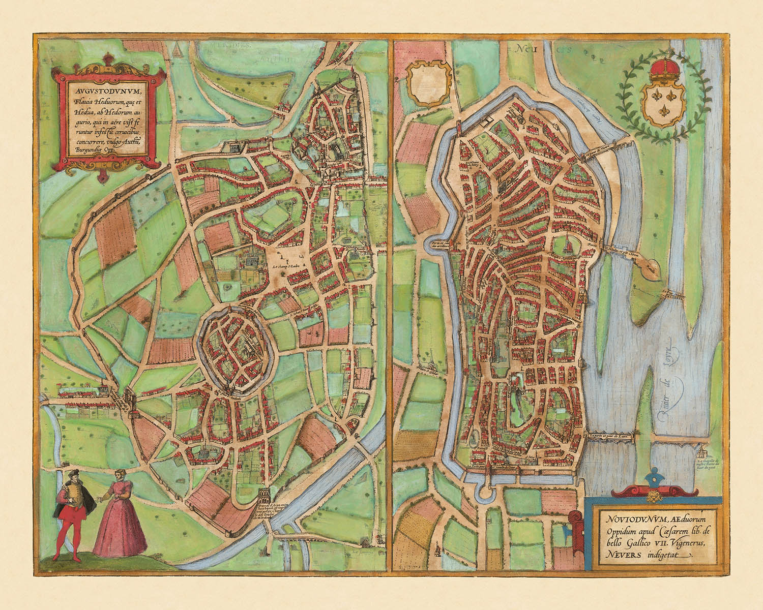
Step into the world of late Renaissance France with this exquisite city map, titled "[Autun and Nevers] Augustodunum, Flavia Heduorum, que et Hedua, ab Hedorum augurio . . . / Noviodunum, Aeduorum Oppidum apud Casearem lib. de bello Gallico VII Vigenerus, Nevers indigetat." Crafted in 1581 by the celebrated duo Georg Braun and Frans Hogenberg, this map is a rare and illuminating window into the urban heart of Burgundy. The original Latin title, steeped in classical and Gallic references, immediately signals the historical depth and significance of the cities depicted—Autun (Augustodunum) and Nevers (Noviodunum)—both of which played prominent roles in Roman and medieval French history.
What sets this map apart is its breathtaking bird’s-eye perspective, a hallmark of Braun & Hogenberg’s artistry. The walled cities of Autun and Nevers are rendered with meticulous attention to their fortifications, revealing the defensive priorities of the era. The map captures the intricate geometry of city walls, bastions, and gates, all nestled within a verdant countryside. Flowing rivers—the Arroux by Autun and the majestic Loire by Nevers—snake through the landscape, their stone bridges connecting bustling urban life to the fertile fields beyond.
Within the city walls, significant landmarks leap to the fore. In Autun, the grand Cathedral of Saint-Lazare dominates the skyline, its Romanesque towers a testament to the city’s ecclesiastical heritage. Nevers, too, boasts its imposing cathedral and the fortified Ducal Palace, each structure carefully illustrated to convey their architectural gravitas. Decorative cartouches and heraldic shields embellish the composition, underscoring the civic pride and noble lineage of these historic centers.
This map is not merely a record of streets and buildings; it is a celebration of urban identity and Renaissance cartographic achievement. Figures in period dress animate the foreground, offering a glimpse into the daily life and social fabric of the 16th century. The surrounding countryside, dotted with rural homes and open fields, provides a dramatic contrast to the dense urban cores, highlighting the interplay between city and hinterland that shaped the region’s prosperity.
The historical significance of this map is amplified by its inclusion in the legendary Civitates Orbis Terrarum, the six-volume atlas that set the standard for city mapping in early modern Europe. Braun & Hogenberg’s collaboration produced some of the most influential city views of their time, and this map of Autun and Nevers stands as a testament to their vision. It is an essential acquisition for collectors and connoisseurs who appreciate the fusion of artistry, history, and urban geography at the dawn of the modern age.
Notable Features & Landmarks
- Two main city views: Autun (Augustodunum) and Nevers (Noviodunum), each depicted in detail.
- City walls and fortifications surrounding both Autun and Nevers.
- Rivers running through or near both cities (the Arroux River for Autun and the Loire River for Nevers).
- Prominent cathedrals or churches visible in both cities (notably the Cathedral of Saint-Lazare in Autun and the Nevers Cathedral).
- Castles or fortified structures within or adjacent to the city walls.
- Bridges crossing the rivers near the cities.
- Open countryside, fields, and rural buildings surrounding the urban centers.
- Decorative cartouches with Latin titles and descriptive text.
- Figures in period dress depicted in the foreground for decorative and contextual effect.
- Heraldic shields or coats of arms associated with the cities.
Historical and design context
- Name of the map: [Autun and Nevers] Augustodunum, Flavia Heduorum, que et Hedua, ab Hedorum augurio . . . / Noviodunum, Aeduorum Oppidum apud Casearem lib. de bello Gallico VII Vigenerus, Nevers indigetat.
- This is a notable example of early city plans of Autun and Nevers, featured in Braun & Hogenberg's monumental 6-volume work, Civitates Orbis Terrarum, which was one of the earliest comprehensive atlases of city views and maps.
- Date made: 1581.
- Mapmakers/publishers: Georg Braun & Frans Hogenberg, renowned for their collaboration on the Civitates Orbis Terrarum (published 1572–1617), a landmark atlas that depicted cities across Europe and beyond.
- The map presents bird’s-eye view pictorial representations of the cities of Autun and Nevers (in present-day France), focusing on urban layout, fortifications, and significant buildings.
- The map is a city bird’s-eye view, typical of late 16th-century European cartography, with detailed illustrations of buildings, fortifications, rivers, and surrounding countryside.
- The map provides valuable insight into the urban form, architecture, and defensive structures of French cities in the late Renaissance. It is also significant as part of the Civitates Orbis Terrarum, which helped shape European perceptions of cities and urban geography during the period.
Please double check the images to make sure that a specific town or place is shown on this map. You can also get in touch and ask us to check the map for you.
This map looks great at every size, but I always recommend going for a larger size if you have space. That way you can easily make out all of the details.
This map looks amazing at sizes all the way up to 70in (180cm). If you are looking for a larger map, please get in touch.
The model in the listing images is holding the 16x20in (40x50cm) version of this map.
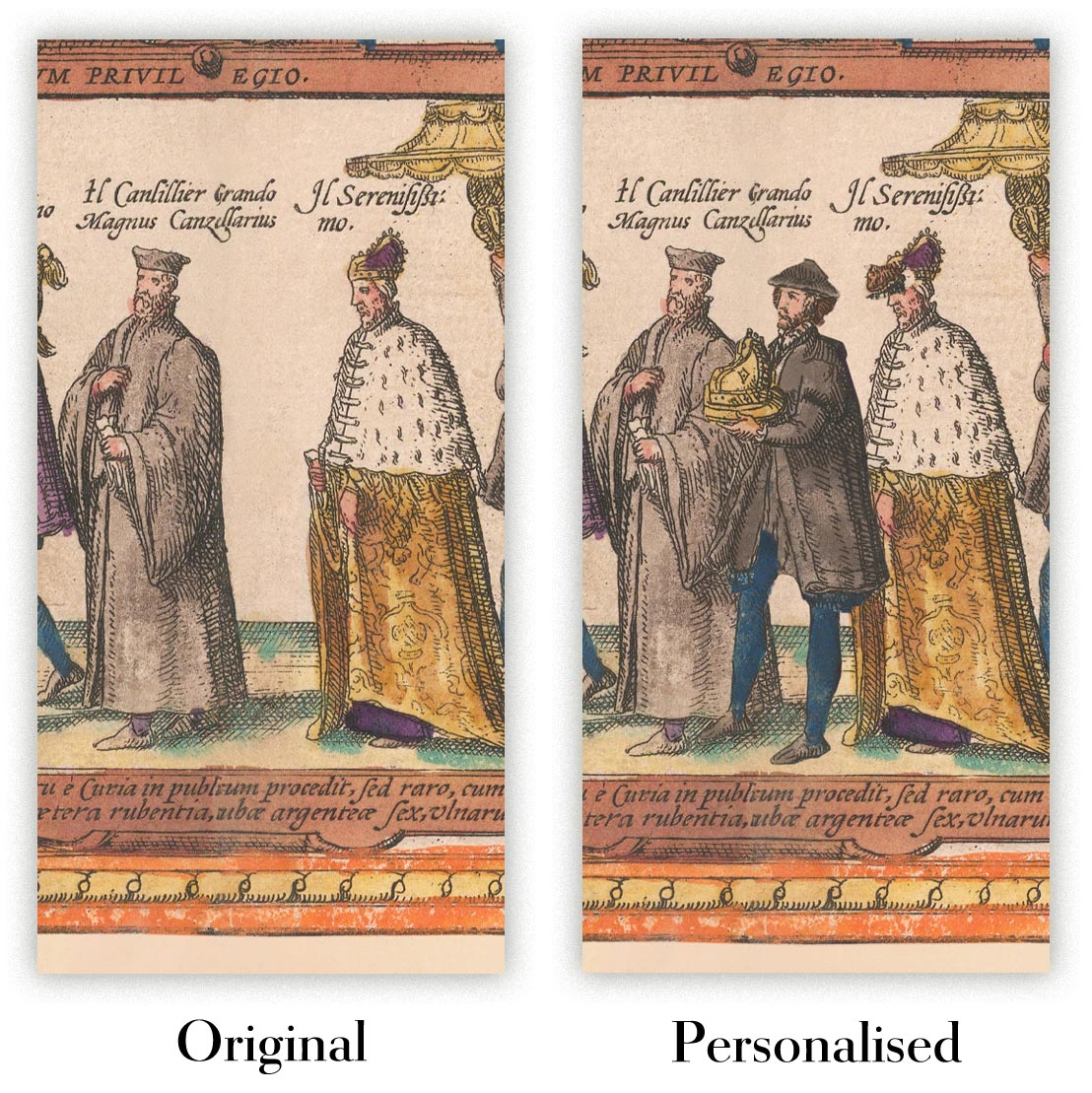
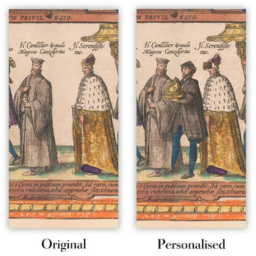
The fifth listing image shows an example of my map personalisation service.
If you’re looking for something slightly different, check out my collection of the best old maps to see if something else catches your eye.
Please contact me to check if a certain location, landmark or feature is shown on this map.
This would make a wonderful birthday, Christmas, Father's Day, work leaving, anniversary or housewarming gift for someone from the areas covered by this map.
This map is available as a giclée print on acid free archival matte paper, or you can buy it framed. The frame is a nice, simple black frame that suits most aesthetics. Please get in touch if you'd like a different frame colour or material. My frames are glazed with super-clear museum-grade acrylic (perspex/acrylite), which is significantly less reflective than glass, safer, and will always arrive in perfect condition.
This map is also available as a float framed canvas, sometimes known as a shadow gap framed canvas or canvas floater. The map is printed on artist's cotton canvas and then stretched over a handmade box frame. We then "float" the canvas inside a wooden frame, which is available in a range of colours (black, dark brown, oak, antique gold and white). This is a wonderful way to present a map without glazing in front. See some examples of float framed canvas maps and explore the differences between my different finishes.
For something truly unique, this map is also available in "Unique 3D", our trademarked process that dramatically transforms the map so that it has a wonderful sense of depth. We combine the original map with detailed topography and elevation data, so that mountains and the terrain really "pop". For more info and examples of 3D maps, check my Unique 3D page.
Many of our maps and art prints are chosen as thoughtful gifts for homes, offices, studies and meaningful places.
Choose a framed option for the easiest ready-to-hang gift, or choose an unframed print if the recipient may prefer to select their own frame.
We make orders locally in 23 countries around the world, so gifts can often be produced close to the recipient. This helps them arrive faster, travel more safely, and avoid customs or import duty surprises.
- We can deliver directly to the recipient
- Framed pieces arrive ready to hang
- Unframed prints are carefully packed in a strong protective tube
- Almost every order is made locally, for faster, safer gifting
- 90-day returns give the recipient time to decide
If you are not sure what to choose, please contact us. We can help you pick the right map, size, finish or delivery option.
Most orders are made locally and delivered in around 2–3 working days, depending on the product, size and destination.
We print and frame maps and artwork in 23 countries around the world, so your order is usually made close to you or your recipient. That means faster delivery, less time in transit, and no customs or import duty surprises.
Personalised and customised pieces usually take an extra 1–2 working days, because we prepare your design and send it to you for approval before printing.
Very large framed orders can take a little longer, as they need extra care in production and delivery.
Every order is carefully packaged: unframed prints are sent in a strong protective tube, while framed pieces are securely packed with protective materials around the frame.
If you need your order by a particular date, please contact us before ordering. We’ll check the best production route and delivery option for your location.
Express delivery is available at checkout for most countries. Next-day delivery is available in the UK, US, Singapore and the UAE.
Your order is covered by our 90-day returns policy and 10-year guarantee.
Our standard frame is a gallery-style black ash hardwood frame, with a simple, modern look. It is approximately 20mm (0.8in) wide. You can also view some lovely customer photos of framed maps and art.
We use super-clear acrylic glazing, also known as Perspex or Acrylite, instead of traditional glass. It is lighter, safer, and has lower reflectivity, giving the artwork a clearer, cleaner appearance.
Six standard frame colours are available at no extra cost: black, dark brown, dark grey, oak, white, and antique gold. Custom framing and mounting/matting is also available for customers looking for something more specific.
Most maps, art prints, and illustrations are also available as a framed canvas. We use matte cotton canvas, stretch it over a sustainably sourced wooden box frame, and then float the piece within a wooden outer frame. The finished result is beautifully presented, with no glazing between you and the artwork.
All frames are supplied ready to hang, with either string or brackets fitted to the back. Very large frames will include heavy-duty hanging plates and/or a mounting baton. If you have any questions, please get in touch.
We can also supply old maps and artwork on canvas, foam board, cotton rag, and other materials.
If you would prefer to frame your map or artwork yourself, please read our size guide before ordering.
My maps are extremely high quality reproductions of original maps.
I source original, rare maps from libraries, auction houses and private collections around the world, restore them at my London workshop, and then use specialist giclée inks and printers to create beautiful maps that look even better than the original.
My maps are printed on acid-free archival matte (not glossy) paper that feels very high quality and almost like card. In technical terms the paper weight/thickness is 10mil/200gsm. It's perfect for framing.
I print with Epson ultrachrome giclée UV fade resistant pigment inks - some of the best inks you can find.
I can also make maps on canvas, cotton rag and other exotic materials.
Learn more about The Unique Maps Co.
Map personalisation
If you're looking for the perfect anniversary or housewarming gift, I can personalise your map to make it truly unique. For example, I can add a short message, or highlight an important location, or add your family's coat of arms.
The options are almost infinite. Please see my map personalisation page for some wonderful examples of what's possible.
To order a personalised map, select "personalise your map" before adding it to your basket.
Get in touch if you're looking for more complex customisations and personalisations.
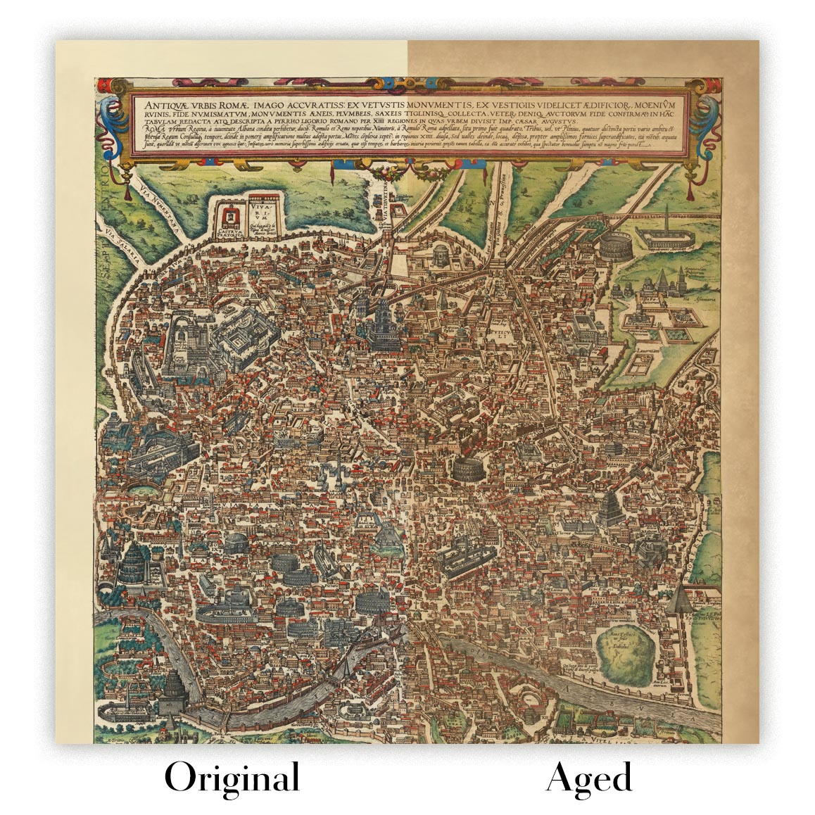
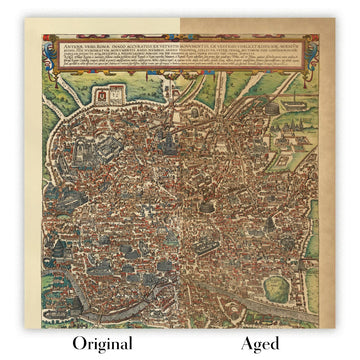
Map ageing
I have been asked hundreds of times over the years by customers if they could buy a map that looks even older.
Well, now you can, by selecting Aged before you add a map to your basket.
All the product photos you see on this page show the map in its Original form. This is what the map looks like today.
If you select Aged, I will age your map by hand, using a special and unique process developed through years of studying old maps, talking to researchers to understand the chemistry of aging paper, and of course... lots of practice!
If you're unsure, stick to the Original colour of the map. If you want something a bit darker and older looking, go for Aged.
If you are not happy with your order for any reason, contact me and I'll get it fixed ASAP, free of charge. Please see my returns and refund policy for more information.
I am very confident you will like your restored map or art print. I have been doing this since 1984. I'm a 5-star Etsy seller. I have sold tens of thousands of maps and art prints and have over 5,000 real 5-star reviews. My work has been featured in interior design magazines, on the BBC, and on the walls of dozens of 5-star hotels.
I use a unique process to restore maps and artwork that is massively time consuming and labour intensive. Hunting down the original maps and illustrations can take months. I use state of the art and eye-wateringly expensive technology to scan and restore them. As a result, I guarantee my maps and art prints are a cut above the rest. I stand by my products and will always make sure you're 100% happy with what you receive.
Almost all of my maps and art prints look amazing at large sizes (200cm, 6.5ft+) and I can frame and deliver them to you as well, via special oversized courier. Contact me to discuss your specific needs.
Or try searching for something!


