


Rare Old Birdseye Map of Lisbon by Braun, 1596: Castelo de São Jorge, Catedral Se, Baixa, Bairro Alto, Tagus River
20% off 2 — 33% off 3
Add any two eligible items to your bag to receive 20% off. Add a third and it will be complimentary (equivalent to 33% off when purchasing three).
No code needed — the offer applies automatically at checkout.
Valid on all standard maps and fine art prints. You can mix and match any designs.
If you’d like to ship items to multiple addresses, please contact us before placing your order.
Custom and bespoke commissions are excluded.
Contact us if you have any questions
 Designed in London Made in Canada
Designed in London • Made in Canada
Designed in London Made in Canada
Designed in London • Made in Canada

Choose your size
Choose your finish


(More info)
Gift message & custom finish

If you want to add a gift message, or a finish (jigsaw, aluminium board, etc.) that is not available here, please request it in the "order note" when you check out.
Every order is custom made, so if you need the size adjusted slightly, or printed on an unusual material, just let us know. We've done thousands of custom orders over the years, so there's (almost) nothing we can't manage.
You can also contact us before you order, if you prefer!

- Made locally for fast, safe delivery
- No import duty or hidden fees
- Need advice? Message us on WhatsApp
Own a piece of history
7,000+ 5 star reviews


"Olissippo quae nunc Lisboa, civitas amplissima Lusitaniae, ad Tagum, totius Orientis, et multarum Insularum Aphricaeque et Mericae emporium nobilissimum," a masterful creation by Georg Braun in 1596, offers a mesmerizing bird's-eye view of Lisbon. This map, a gem from the "Civitates Orbis Terrarum," captures the essence of Lisbon before the devastating 1755 earthquake. It vividly portrays the city's grandeur, with its bustling streets and intricate architecture, reflecting its pivotal role as a trade center connecting Europe with the Orient, Africa, and the Americas. The detailed engraving not only serves as a historical testament but also as a visual delight for any map enthusiast.
Lisbon, depicted here, was a beacon of maritime exploration and trade during the Age of Discovery. The map highlights the city's significant neighborhoods, such as the Lower Town (Baixa) and the Upper Town (Bairro Alto), showcasing their unique layouts and architectural splendor. The intricate street patterns and the detailed depiction of buildings provide a fascinating glimpse into the urban planning and daily life of 16th-century Lisbon. This map is a window into the past, preserving the city's historical and cultural heritage in exquisite detail.
Among the notable landmarks, the Castelo de São Jorge stands prominently, marked as number 1 on the map. This fortress, once a Moorish stronghold, was reconquered by Alfonso I in 1147 and has since been a symbol of Lisbon's resilience and strategic importance. Another significant landmark is the Catedral Se Patriarcal, marked as number 79, renowned for its Romanesque and Gothic architecture. These landmarks, along with the detailed portrayal of the Tagus River and the bustling maritime activity, underscore Lisbon's historical significance and its role as a gateway to the world.
The map's artistic and historical value is further enhanced by its detailed illustrations, including the ships navigating the Tagus River, which emphasize Lisbon's maritime prowess. The coats of arms and the compass rose add to the map's aesthetic appeal and historical context. This blend of artistry and cartographic precision makes this map not only a valuable historical document but also a captivating piece of art.
Georg Braun, the mastermind behind this map, was a prominent cartographer and publisher known for his meticulous work on the "Civitates Orbis Terrarum." His maps are celebrated for their accuracy, detail, and artistic quality. This particular map of Lisbon is a testament to his skill and dedication, offering a rich, immersive experience of one of Europe's most historically significant cities. Owning this map is akin to holding a piece of history, a tangible connection to the vibrant past of Lisbon.
Streets and roads on this map
- Rua Nova dos Mercadores
- Rua do Arsenal
- Rua dos Bacalhoeiros
- Rua da Prata
- Rua Augusta
- Rua da Madalena
- Rua de São Julião
- Rua dos Fanqueiros
- Rua dos Douradores
- Rua dos Correeiros
- Rua dos Sapateiros
- Rua da Betesga
- Rua do Ouro
- Rua da Conceição
- Rua do Comércio
- Rua de Santa Justa
- Rua de São Nicolau
- Rua do Carmo
- Rua Garrett
- Rua do Crucifixo
- Rua Nova do Almada
- Rua da Vitória
- Rua do Alecrim
- Rua das Flores
- Rua do Salitre
- Rua da Esperança
- Rua de São Paulo
- Rua dos Remolares
- Rua de São Bento
- Rua da Rosa
Notable Features & Landmarks
- Castelo de São Jorge (1): A historically significant fortress, previously a Moorish stronghold.
- Catedral Se Patriarcal (79): Known for its Romanesque and Gothic architecture.
- Lower Town (Baixa): Depicted in the map's detailed portrayal of Lisbon's urban landscape.
- Upper Town (Bairro Alto): Another significant area shown in the map.
- Ships in the Tagus River: Illustrates the maritime activity and importance of Lisbon as a trade center.
- Coats of arms: Two coats of arms are depicted in the top corners of the map.
- Compass rose: Located near the top center, indicating directions.
Historical and design context
- Name of the map: Olissippo quae nunc Lisboa, civitas amplissima Lusitaniae, ad Tagum, totius Orientis, et multarum Insularum Aphricaeque et Mericae emporium nobilissimum.
- Creation date: 1596
- Mapmaker/Publisher: Georg Braun
- Context about the mapmaker: Georg Braun was a notable cartographer and publisher, known for his work on the "Civitates Orbis Terrarum," a comprehensive atlas of city maps and views.
- Themes shown on the map:
- Cityscape and architecture: The map provides a bird's-eye view of Lisbon's architecture and urban landscape before the 1755 earthquake.
- Maritime exploration and trade: Highlights Lisbon's role as a major trade center connecting the Orient, various islands, Africa, and America.
- Historical landmarks: Includes significant landmarks such as Castelo de São Jorge and Catedral Se Patriarcal.
- Countries and regions shown:
- Lisbon, Portugal: The map focuses on the city of Lisbon, depicting its layout and key features.
- Design/Style:
- Bird's-eye view: Combines side and bird's-eye views to capture the essence of Lisbon.
- Detailed engraving: Rich in detail, illustrating the city's topography and urban landscape.
- Historical significance:
- Pre-1755 earthquake Lisbon: Provides a valuable glimpse into the city's architecture and layout before the catastrophic earthquake.
- Maritime importance: Reflects Lisbon's significance in global commerce and navigation during the era of exploration and cultural exchange.
Please double check the images to make sure that a specific town or place is shown on this map. You can also get in touch and ask us to check the map for you.
This map looks great at every size, but I always recommend going for a larger size if you have space. That way you can easily make out all of the details.
This map looks amazing at sizes all the way up to 70in (180cm). If you are looking for a larger map, please get in touch.
The model in the listing images is holding the 16x20in (40x50cm) version of this map.
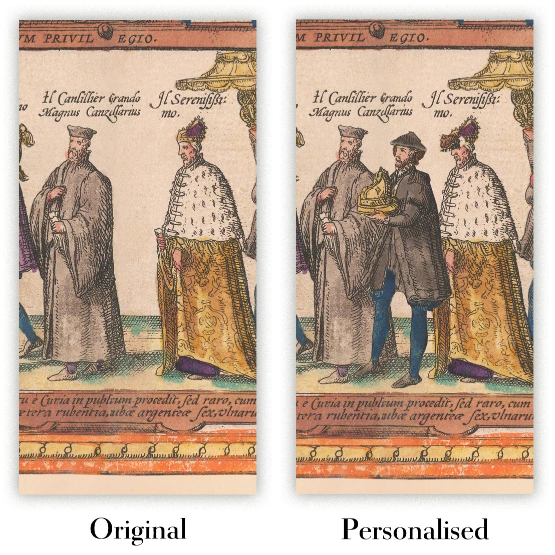
The fifth listing image shows an example of my map personalisation service.
If you’re looking for something slightly different, check out my collection of the best old maps to see if something else catches your eye.
Please contact me to check if a certain location, landmark or feature is shown on this map.
This would make a wonderful birthday, Christmas, Father's Day, work leaving, anniversary or housewarming gift for someone from the areas covered by this map.
This map is available as a giclée print on acid free archival matte paper, or you can buy it framed. The frame is a nice, simple black frame that suits most aesthetics. Please get in touch if you'd like a different frame colour or material. My frames are glazed with super-clear museum-grade acrylic (perspex/acrylite), which is significantly less reflective than glass, safer, and will always arrive in perfect condition.
This map is also available as a float framed canvas, sometimes known as a shadow gap framed canvas or canvas floater. The map is printed on artist's cotton canvas and then stretched over a handmade box frame. We then "float" the canvas inside a wooden frame, which is available in a range of colours (black, dark brown, oak, antique gold and white). This is a wonderful way to present a map without glazing in front. See some examples of float framed canvas maps and explore the differences between my different finishes.
For something truly unique, this map is also available in "Unique 3D", our trademarked process that dramatically transforms the map so that it has a wonderful sense of depth. We combine the original map with detailed topography and elevation data, so that mountains and the terrain really "pop". For more info and examples of 3D maps, check my Unique 3D page.
Many of our maps and art prints are chosen as thoughtful gifts for homes, offices, studies and meaningful places.
Choose a framed option for the easiest ready-to-hang gift, or choose an unframed print if the recipient may prefer to select their own frame.
We make orders locally in 23 countries around the world, so gifts can often be produced close to the recipient. This helps them arrive faster, travel more safely, and avoid customs or import duty surprises.
- We can deliver directly to the recipient
- Framed pieces arrive ready to hang
- Unframed prints are carefully packed in a strong protective tube
- Almost every order is made locally, for faster, safer gifting
- 90-day returns give the recipient time to decide
If you are not sure what to choose, please contact us. We can help you pick the right map, size, finish or delivery option.
Most orders are made locally and delivered in around 2–3 working days, depending on the product, size and destination.
We print and frame maps and artwork in 23 countries around the world, so your order is usually made close to you or your recipient. That means faster delivery, less time in transit, and no customs or import duty surprises.
Personalised and customised pieces usually take an extra 1–2 working days, because we prepare your design and send it to you for approval before printing.
Very large framed orders can take a little longer, as they need extra care in production and delivery.
Every order is carefully packaged: unframed prints are sent in a strong protective tube, while framed pieces are securely packed with protective materials around the frame.
If you need your order by a particular date, please contact us before ordering. We’ll check the best production route and delivery option for your location.
Express delivery is available at checkout for most countries. Next-day delivery is available in the UK, US, Singapore and the UAE.
Your order is covered by our 90-day returns policy and 10-year guarantee.
Our standard frame is a gallery-style black ash hardwood frame, with a simple, modern look. It is approximately 20mm (0.8in) wide. You can also view some lovely customer photos of framed maps and art.
We use super-clear acrylic glazing, also known as Perspex or Acrylite, instead of traditional glass. It is lighter, safer, and has lower reflectivity, giving the artwork a clearer, cleaner appearance.
Six standard frame colours are available at no extra cost: black, dark brown, dark grey, oak, white, and antique gold. Custom framing and mounting/matting is also available for customers looking for something more specific.
Most maps, art prints, and illustrations are also available as a framed canvas. We use matte cotton canvas, stretch it over a sustainably sourced wooden box frame, and then float the piece within a wooden outer frame. The finished result is beautifully presented, with no glazing between you and the artwork.
All frames are supplied ready to hang, with either string or brackets fitted to the back. Very large frames will include heavy-duty hanging plates and/or a mounting baton. If you have any questions, please get in touch.
We can also supply old maps and artwork on canvas, foam board, cotton rag, and other materials.
If you would prefer to frame your map or artwork yourself, please read our size guide before ordering.
My maps are extremely high quality reproductions of original maps.
I source original, rare maps from libraries, auction houses and private collections around the world, restore them at my London workshop, and then use specialist giclée inks and printers to create beautiful maps that look even better than the original.
My maps are printed on acid-free archival matte (not glossy) paper that feels very high quality and almost like card. In technical terms the paper weight/thickness is 10mil/200gsm. It's perfect for framing.
I print with Epson ultrachrome giclée UV fade resistant pigment inks - some of the best inks you can find.
I can also make maps on canvas, cotton rag and other exotic materials.
Learn more about The Unique Maps Co.
Map personalisation
If you're looking for the perfect anniversary or housewarming gift, I can personalise your map to make it truly unique. For example, I can add a short message, or highlight an important location, or add your family's coat of arms.
The options are almost infinite. Please see my map personalisation page for some wonderful examples of what's possible.
To order a personalised map, select "personalise your map" before adding it to your basket.
Get in touch if you're looking for more complex customisations and personalisations.
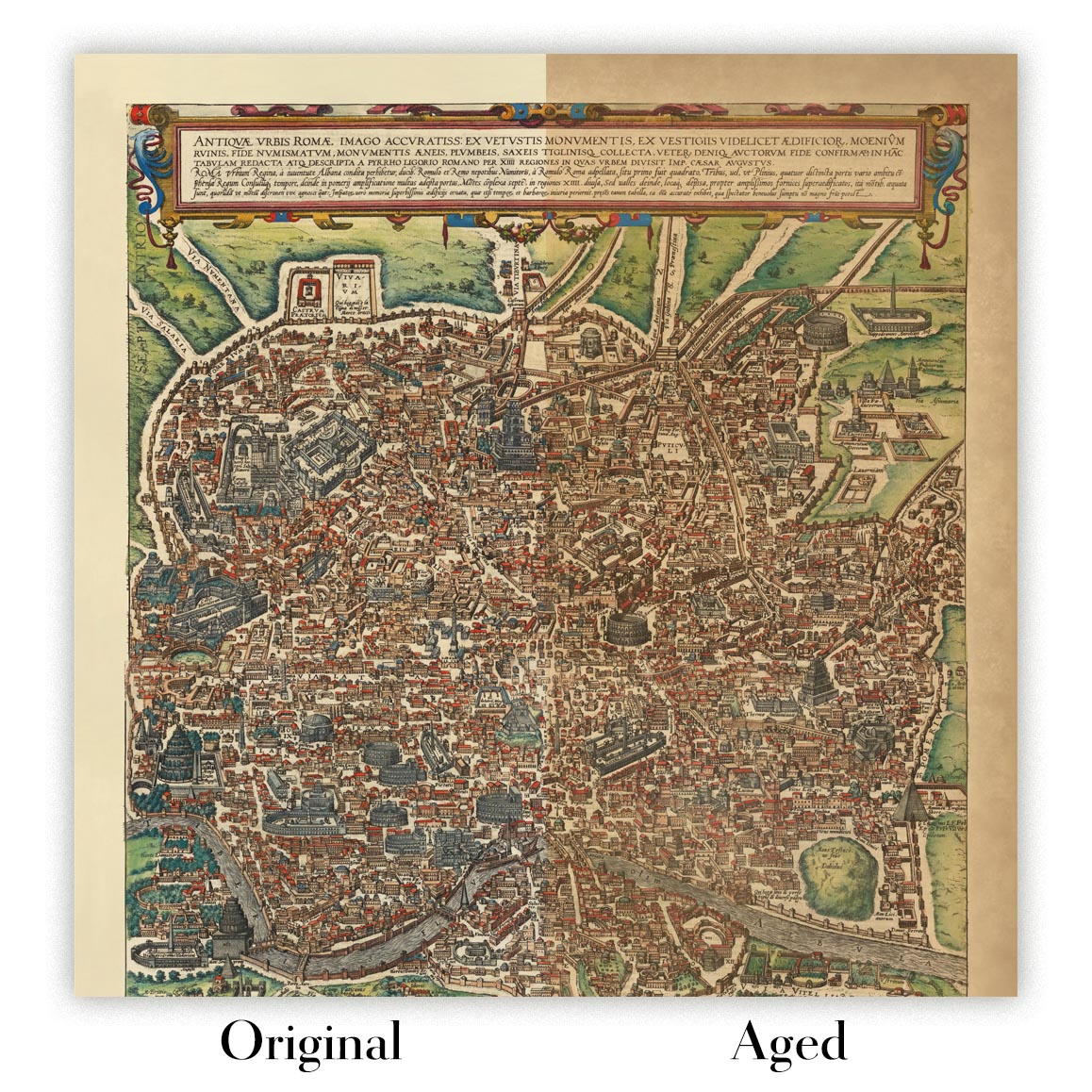
Map ageing
I have been asked hundreds of times over the years by customers if they could buy a map that looks even older.
Well, now you can, by selecting Aged before you add a map to your basket.
All the product photos you see on this page show the map in its Original form. This is what the map looks like today.
If you select Aged, I will age your map by hand, using a special and unique process developed through years of studying old maps, talking to researchers to understand the chemistry of aging paper, and of course... lots of practice!
If you're unsure, stick to the Original colour of the map. If you want something a bit darker and older looking, go for Aged.
If you are not happy with your order for any reason, contact me and I'll get it fixed ASAP, free of charge. Please see my returns and refund policy for more information.
I am very confident you will like your restored map or art print. I have been doing this since 1984. I'm a 5-star Etsy seller. I have sold tens of thousands of maps and art prints and have over 5,000 real 5-star reviews. My work has been featured in interior design magazines, on the BBC, and on the walls of dozens of 5-star hotels.
I use a unique process to restore maps and artwork that is massively time consuming and labour intensive. Hunting down the original maps and illustrations can take months. I use state of the art and eye-wateringly expensive technology to scan and restore them. As a result, I guarantee my maps and art prints are a cut above the rest. I stand by my products and will always make sure you're 100% happy with what you receive.
Almost all of my maps and art prints look amazing at large sizes (200cm, 6.5ft+) and I can frame and deliver them to you as well, via special oversized courier. Contact me to discuss your specific needs.
Or try searching for something!


