


Rare Old Map of Bali by Schley, 1770: Ville de Baly, Palaces, Compass Roses, Mountains, Rivers
The Collector’s Offer
Choose two eligible works and receive 20% off both. Choose three and the lowest-priced one is complimentary, a maximum saving of 33%.
Mix and match eligible standard maps and fine-art prints. No code is required; the offer is applied automatically at checkout.
Standard made-to-order configurations are included. Bespoke sizes, personalised designs and commissioned work are excluded.
Need delivery to different addresses? Contact us before ordering.The Collector’s Offer
Choose two eligible works and receive 20% off both. Choose three and the lowest-priced one is complimentary, a maximum saving of 33%.
Mix and match eligible standard maps and fine-art prints. No code is required; the offer is applied automatically at checkout.
Standard made-to-order configurations are included. Bespoke sizes, personalised designs and commissioned work are excluded.
Need delivery to different addresses? Contact us before ordering. Restored in London • Made in Canada

Restored from the original 1770 map and printed to museum-grade archival standards. Read the story behind this map
Choose your size
Choose your finish


(More info)
Gift message & custom finish

If you want to add a gift message, or a finish (jigsaw, aluminium board, etc.) that is not available here, please request it in the "order note" when you check out.
Every order is custom made, so if you need the size adjusted slightly, or printed on an unusual material, just let us know. We've done thousands of custom orders over the years, so there's (almost) nothing we can't manage.
You can also contact us before you order, if you prefer!

- Made locally for fast, safe delivery
- No import duty or hidden fees
- Need advice? Call us or message on WhatsApp
Own a piece of history
8,000+ five-star reviews


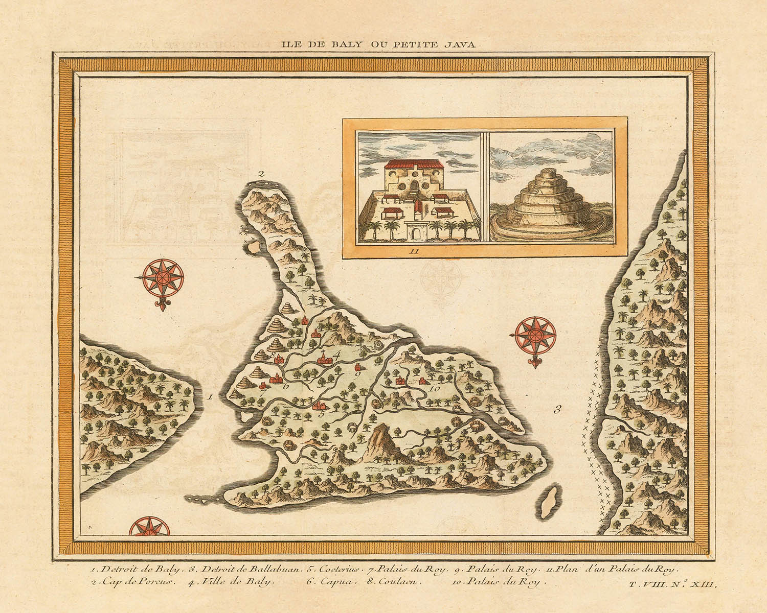
The "Ile de Baly ou Petite Java" map, crafted by the esteemed Jacob Van Schley in 1770, is a captivating glimpse into...
Continue readingThe "Ile de Baly ou Petite Java" map, crafted by the esteemed Jacob Van Schley in 1770, is a captivating glimpse into the cartographic artistry of the 18th century. Schley, renowned for his detailed and artistic maps, published this piece in Amsterdam, capturing the allure of Bali during a time when European explorers were charting the exotic East Indies. The map is a testament to the Age of Discovery, reflecting the era's thirst for knowledge and adventure, and it stands as a beautiful relic of European exploration in Southeast Asia.
This map is a masterpiece of design, featuring intricate compass roses and artistic embellishments that are characteristic of the period. It draws inspiration from an earlier map by Willem Lodewijcksz, who participated in Cornelius de Houtman's pioneering voyage to the East Indies between 1595 and 1597. The detailed representation of Bali's geography, including its coastal outlines, mountains, and rivers, offers a fascinating look at how the island was perceived by European explorers of the time.
Significant political and cultural landmarks are meticulously marked, with the palaces of the King prominently displayed, indicating the island's centers of power. The inclusion of a key or legend provides clarity to the map's rich tapestry of place names and features, while illustrations of a palace and a temple add a layer of visual intrigue. These elements not only enhance the map's aesthetic appeal but also serve as historical markers of Bali's significance in trade and exploration.
The map's depiction of Bali, known then as "Petite Java," highlights the island's strategic importance in the region. It features several towns and settlements, such as Ville de Baly and Cap de Perrue, each marked with care and precision. These settlements, along with the detailed physical geography, paint a vivid picture of the island as it was understood by Europeans in the 18th century, showcasing Bali's allure and mystique.
In essence, this map is more than just a navigational tool; it is a window into a world of exploration and cultural exchange. It captures the imagination with its blend of artistry and historical context, offering a glimpse into the rich tapestry of Bali's past. For collectors and enthusiasts of historical cartography, Jacob Van Schley's map is a treasure that embodies the spirit of discovery and the enduring allure of distant lands.
Cities and towns on this map
- Bali:
- Ville de Baly
- Cap de Perrue
- Debruit de Baly
- Debruit de Ballabhaan
- Cordisan
- Capua
- Condan
Notable Features & Landmarks
- Palaces of the King: Multiple palaces are marked, indicating political centers.
- Compass Roses: Decorative compass roses are included for navigation.
- Illustrations: Includes illustrations of a palace and a temple, adding visual interest.
- Geographic Features: Coastal outlines, mountains, and rivers are depicted.
- Key/Legend: Provides names for important locations and features.
Historical and design context
- Creation date: 1770
- Mapmaker/Publisher: Jacob Van Schley, known for detailed and artistic maps.
- Historical context: Based on a map from the late 17th century by Willem Lodewijcksz, linked to Cornelius de Houtman's voyage to the East Indies (1595-97).
- Themes and topics: Reflects European exploration and mapping of Southeast Asia during the Age of Discovery.
- Design/Style: Detailed cartographic representation with artistic embellishments typical of the 18th century.
- Significance: Illustrates European interest in Southeast Asia and the importance of Bali in trade and exploration.
Please double check the images to make sure that a specific town or place is shown on this map. You can also get in touch and ask us to check the map for you.
This map looks great at every size, but I always recommend going for a larger size if you have space. That way you can easily make out all of the details.
This map looks amazing at sizes all the way up to 40in (100cm). If you are looking for a larger map, please get in touch.
The model in the listing images is holding the 16x20in (40x50cm) version of this map.
The fifth listing image shows an example of my map personalisation service.
If you’re looking for something slightly different, check out my collection of the best old maps to see if something else catches your eye.
Please contact me to check if a certain location, landmark or feature is shown on this map.
This would make a wonderful birthday, Christmas, Father's Day, work leaving, anniversary or housewarming gift for someone from the areas covered by this map.
This map is available as a giclée print on acid free archival matte paper, or you can buy it framed. The frame is a nice, simple black frame that suits most aesthetics. Please get in touch if you'd like a different frame colour or material. My frames are glazed with super-clear museum-grade acrylic (perspex/acrylite), which is significantly less reflective than glass, safer, and will always arrive in perfect condition.
This map is also available as a float framed canvas, sometimes known as a shadow gap framed canvas or canvas floater. The map is printed on artist's cotton canvas and then stretched over a handmade box frame. We then "float" the canvas inside a wooden frame, which is available in a range of colours (black, dark brown, oak, antique gold and white). This is a wonderful way to present a map without glazing in front. See some examples of float framed canvas maps and explore the differences between my different finishes.
For something truly unique, this map is also available in "Unique 3D", our trademarked process that dramatically transforms the map so that it has a wonderful sense of depth. We combine the original map with detailed topography and elevation data, so that mountains and the terrain really "pop". For more info and examples of 3D maps, check my Unique 3D page.
The "Ile de Baly ou Petite Java" map, crafted by the esteemed Jacob Van Schley in 1770, is a captivating glimpse into the cartographic artistry of the 18th century. Schley, renowned for his detailed and artistic maps, published this piece in Amsterdam, capturing the allure of Bali during a time when European explorers were charting the exotic East Indies. The map is a testament to the Age of Discovery, reflecting the era's thirst for knowledge and adventure, and it stands as a beautiful relic of European exploration in Southeast Asia.
This map is a masterpiece of design, featuring intricate compass roses and artistic embellishments that are characteristic of the period. It draws inspiration from an earlier map by Willem Lodewijcksz, who participated in Cornelius de Houtman's pioneering voyage to the East Indies between 1595 and 1597. The detailed representation of Bali's geography, including its coastal outlines, mountains, and rivers, offers a fascinating look at how the island was perceived by European explorers of the time.
Significant political and cultural landmarks are meticulously marked, with the palaces of the King prominently displayed, indicating the island's centers of power. The inclusion of a key or legend provides clarity to the map's rich tapestry of place names and features, while illustrations of a palace and a temple add a layer of visual intrigue. These elements not only enhance the map's aesthetic appeal but also serve as historical markers of Bali's significance in trade and exploration.
The map's depiction of Bali, known then as "Petite Java," highlights the island's strategic importance in the region. It features several towns and settlements, such as Ville de Baly and Cap de Perrue, each marked with care and precision. These settlements, along with the detailed physical geography, paint a vivid picture of the island as it was understood by Europeans in the 18th century, showcasing Bali's allure and mystique.
In essence, this map is more than just a navigational tool; it is a window into a world of exploration and cultural exchange. It captures the imagination with its blend of artistry and historical context, offering a glimpse into the rich tapestry of Bali's past. For collectors and enthusiasts of historical cartography, Jacob Van Schley's map is a treasure that embodies the spirit of discovery and the enduring allure of distant lands.
Cities and towns on this map
- Bali:
- Ville de Baly
- Cap de Perrue
- Debruit de Baly
- Debruit de Ballabhaan
- Cordisan
- Capua
- Condan
Notable Features & Landmarks
- Palaces of the King: Multiple palaces are marked, indicating political centers.
- Compass Roses: Decorative compass roses are included for navigation.
- Illustrations: Includes illustrations of a palace and a temple, adding visual interest.
- Geographic Features: Coastal outlines, mountains, and rivers are depicted.
- Key/Legend: Provides names for important locations and features.
Historical and design context
- Creation date: 1770
- Mapmaker/Publisher: Jacob Van Schley, known for detailed and artistic maps.
- Historical context: Based on a map from the late 17th century by Willem Lodewijcksz, linked to Cornelius de Houtman's voyage to the East Indies (1595-97).
- Themes and topics: Reflects European exploration and mapping of Southeast Asia during the Age of Discovery.
- Design/Style: Detailed cartographic representation with artistic embellishments typical of the 18th century.
- Significance: Illustrates European interest in Southeast Asia and the importance of Bali in trade and exploration.
Please double check the images to make sure that a specific town or place is shown on this map. You can also get in touch and ask us to check the map for you.
This map looks great at every size, but I always recommend going for a larger size if you have space. That way you can easily make out all of the details.
This map looks amazing at sizes all the way up to 40in (100cm). If you are looking for a larger map, please get in touch.
The model in the listing images is holding the 16x20in (40x50cm) version of this map.
The fifth listing image shows an example of my map personalisation service.
If you’re looking for something slightly different, check out my collection of the best old maps to see if something else catches your eye.
Please contact me to check if a certain location, landmark or feature is shown on this map.
This would make a wonderful birthday, Christmas, Father's Day, work leaving, anniversary or housewarming gift for someone from the areas covered by this map.
This map is available as a giclée print on acid free archival matte paper, or you can buy it framed. The frame is a nice, simple black frame that suits most aesthetics. Please get in touch if you'd like a different frame colour or material. My frames are glazed with super-clear museum-grade acrylic (perspex/acrylite), which is significantly less reflective than glass, safer, and will always arrive in perfect condition.
This map is also available as a float framed canvas, sometimes known as a shadow gap framed canvas or canvas floater. The map is printed on artist's cotton canvas and then stretched over a handmade box frame. We then "float" the canvas inside a wooden frame, which is available in a range of colours (black, dark brown, oak, antique gold and white). This is a wonderful way to present a map without glazing in front. See some examples of float framed canvas maps and explore the differences between my different finishes.
For something truly unique, this map is also available in "Unique 3D", our trademarked process that dramatically transforms the map so that it has a wonderful sense of depth. We combine the original map with detailed topography and elevation data, so that mountains and the terrain really "pop". For more info and examples of 3D maps, check my Unique 3D page.
Many of our maps and art prints are chosen as thoughtful gifts for homes, offices, studies and meaningful places.
Choose a framed option for the easiest ready-to-hang gift, or choose an unframed print if the recipient may prefer to select their own frame.
We make orders locally in 23 countries around the world, so gifts can often be produced close to the recipient. This helps them arrive faster, travel more safely, and avoid customs or import duty surprises.
- We can deliver directly to the recipient
- Framed pieces arrive ready to hang
- Unframed prints are carefully packed in a strong protective tube
- Almost every order is made locally, for faster, safer gifting
- 90-day returns give the recipient time to decide
If you are not sure what to choose, please contact us. We can help you pick the right map, size, finish or delivery option.
Most orders are made locally and delivered in around 2–3 working days, depending on the product, size and destination.
We print and frame maps and artwork in 23 countries around the world, so your order is usually made close to you or your recipient. That means faster delivery, less time in transit, and no customs or import duty surprises.
Personalised and customised pieces usually take an extra 1–2 working days, because we prepare your design and send it to you for approval before printing.
Very large framed orders can take a little longer, as they need extra care in production and delivery.
Every order is carefully packaged: unframed prints are sent in a strong protective tube, while framed pieces are securely packed with protective materials around the frame.
If you need your order by a particular date, please contact us before ordering. We’ll check the best production route and delivery option for your location.
Express delivery is available at checkout for most countries. Next-day delivery is available in the UK, US, Singapore and the UAE.
Your order is covered by our 90-day returns policy and 10-year guarantee.
Our standard frame is a gallery-style black ash hardwood frame, with a simple, modern look. It is approximately 20mm (0.8in) wide. You can also view some lovely customer photos of framed maps and art.
We use super-clear acrylic glazing, also known as Perspex or Acrylite, instead of traditional glass. It is lighter, safer, and has lower reflectivity, giving the artwork a clearer, cleaner appearance.
Six standard frame colours are available at no extra cost: black, dark brown, dark grey, oak, white, and antique gold. Custom framing and mounting/matting is also available for customers looking for something more specific.
Most maps, art prints, and illustrations are also available as a framed canvas. We use matte cotton canvas, stretch it over a sustainably sourced wooden box frame, and then float the piece within a wooden outer frame. The finished result is beautifully presented, with no glazing between you and the artwork.
All frames are supplied ready to hang, with either string or brackets fitted to the back. Very large frames will include heavy-duty hanging plates and/or a mounting baton. If you have any questions, please get in touch.
We can also supply old maps and artwork on canvas, foam board, cotton rag, and other materials.
If you would prefer to frame your map or artwork yourself, please read our size guide before ordering.
Every Unique Maps piece begins with an authentic cartographic source or an original design from our London studio.
For our historic maps, we source rare originals from libraries, archives, auction houses and private collections around the world. We carefully restore each map for print—repairing age-related damage, balancing colour and improving clarity while preserving its original detail, texture and character.
Once restored, the map is prepared for your chosen size and finish. Your piece is then printed and, where selected, framed close to its delivery destination.
Our map prints use acid-free 200gsm archival matte paper and fade-resistant pigment inks, creating a rich, non-glossy finish designed to last. Framed maps use crystal-clear optical acrylic and arrive ready to hang.
Canvas, cotton-rag and other specialist presentations are also available. Learn more about our materials and finishes.
Personalising your map
You can add a short title or dedication, mark one meaningful place, or request one considered visual detail. For personalised designs, we send a proof before printing and you can request changes before approval.
For more complex bespoke commissions, contact our design team.
Original or Aged
Choose Original for true-to-source colour, or Aged for a warmer, richer antique character created with our specialist ageing process. See examples of our Aged maps.
If you are not happy with your order for any reason, contact me and I'll get it fixed ASAP, free of charge. Please see my returns and refund policy for more information.
I am very confident you will like your restored map or art print. I have been doing this since 1984. I'm a 5-star Etsy seller. I have sold tens of thousands of maps and art prints and have over 5,000 real 5-star reviews. My work has been featured in interior design magazines, on the BBC, and on the walls of dozens of 5-star hotels.
I use a unique process to restore maps and artwork that is massively time consuming and labour intensive. Hunting down the original maps and illustrations can take months. I use state of the art and eye-wateringly expensive technology to scan and restore them. As a result, I guarantee my maps and art prints are a cut above the rest. I stand by my products and will always make sure you're 100% happy with what you receive.
Almost all of my maps and art prints look amazing at large sizes (200cm, 6.5ft+) and I can frame and deliver them to you as well, via special oversized courier. Contact me to discuss your specific needs.
Or try searching for something!


