


Rare Old Map of Mexico, Guatemala, Texas, California by H.S. Tanner, 1839: Mexico City, Puebla, Los Angeles, San Francisco, Austin, Houston
20% off 2 — 33% off 3
Add any two eligible items to your bag to receive 20% off. Add a third and it will be complimentary (equivalent to 33% off when purchasing three).
No code needed — the offer applies automatically at checkout.
Valid on all standard maps and fine art prints. You can mix and match any designs.
If you’d like to ship items to multiple addresses, please contact us before placing your order.
Custom and bespoke commissions are excluded.
Contact us if you have any questions
 Designed in London Made in Canada
Designed in London • Made in Canada
Designed in London Made in Canada
Designed in London • Made in Canada

Restored from the original 1839 map and printed to museum-grade archival standards. Read the story behind this map
Choose your size
Choose your finish


(More info)
Gift message & custom finish

If you want to add a gift message, or a finish (jigsaw, aluminium board, etc.) that is not available here, please request it in the "order note" when you check out.
Every order is custom made, so if you need the size adjusted slightly, or printed on an unusual material, just let us know. We've done thousands of custom orders over the years, so there's (almost) nothing we can't manage.
You can also contact us before you order, if you prefer!

- Made locally for fast, safe delivery
- No import duty or hidden fees
- Need advice? Call us or message on WhatsApp
Own a piece of history
8,000+ five-star reviews


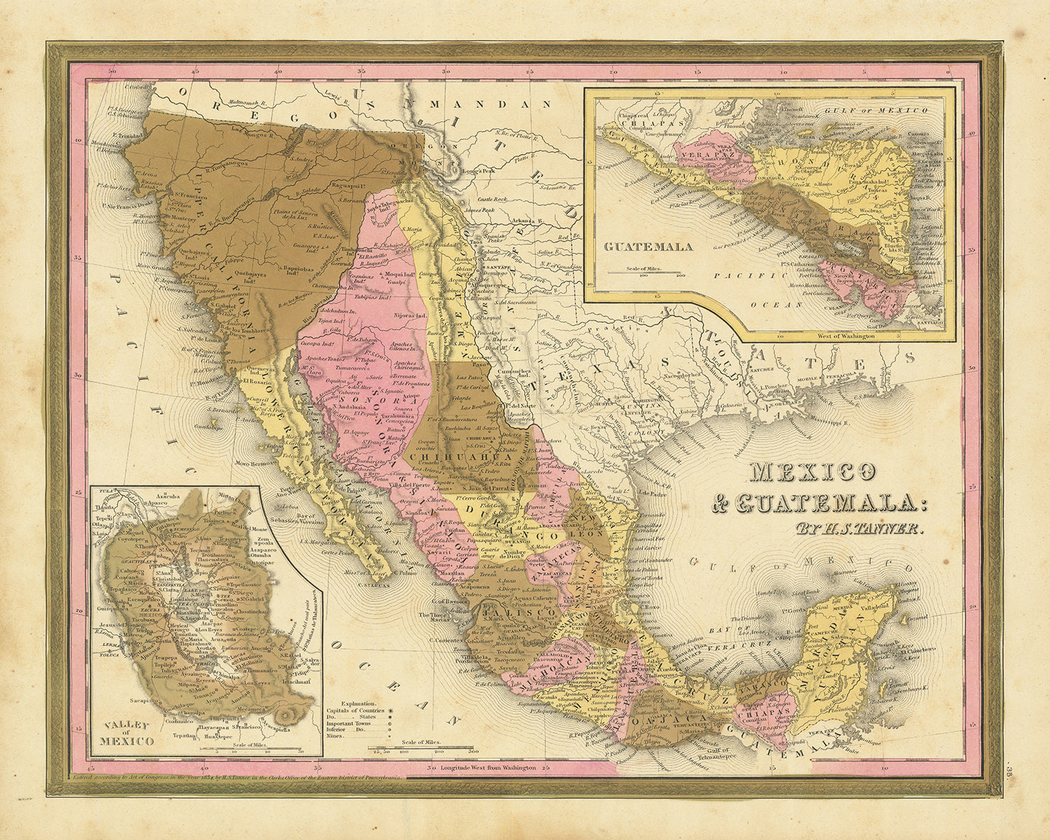
This masterful 1839 map by H.S. Tanner stands as a richly detailed testament to a time of transformation and exploration. This region...
Continue readingThis masterful 1839 map by H.S. Tanner stands as a richly detailed testament to a time of transformation and exploration. This region of Mexico, Guatemala, and Southwest Texas, including what would become the state of California, was in the throes of significant change. As an artifact from an era that pre-dates many modern cities, the map bears the names of early settlements and offers an intriguing opportunity to trace their evolution over time. It's not just a piece of cartography; it's a portal to the past.
What sets this map apart is not just its meticulous detail but the historical context it envelops. The 1830s was a period of considerable political flux, and this map delivers a snapshot of that time, capturing a pre-Californian United States era. Thus, the map invites dialogue and discussions about colonialism, frontier life, and the transformation of the landscape, proving to be much more than a mere decorative item.
Settlements featured
Mexico
- Mexico City (Founded 1325): Originally known as Tenochtitlán, it was the capital of the Aztec Empire, and it is now the most populous city in North America.
- Puebla (Founded 1531): Established by the Spanish in an area known for its intricate pottery and rich culinary tradition.
- Guadalajara (Founded 1532): Named after the Spanish hometown of its founder, Nuño de Guzmán, Guadalajara is now known as Mexico's cultural hub, famous for mariachi music and tequila.
- Veracruz (Founded 1519): Founded by Hernán Cortés, it was the first Spanish settlement on the mainland of the Americas.
- Monterrey (Founded 1596): Named after the Countess of Monterrei, it is now an important industrial and business hub in Mexico.
- Leon (Founded 1576): Known as the leather capital of the world.
- Zacatecas (Founded 1548): A significant city during the Spanish colonial period due to its silver mining.
- San Luis Potosi (Founded 1592): One of the centers of the Mexican War of Independence.
Guatemala
- Guatemala City (Founded 1776): The capital city, it was moved to this location after the previous capital, Antigua Guatemala, was destroyed by an earthquake.
- Antigua Guatemala (Founded 1543): Known for its well-preserved Spanish Baroque-influenced architecture.
- Quetzaltenango (Founded 1524): It was the city where the final battle took place that ended the Mayan resistance against Spanish rule.
- Livingston (Founded 1806): A unique town in Guatemala, home to the Garifuna people.
- Flores (Founded 9th Century AD): Located on a small island on Lake Petén Itzá, it was the last independent Maya state until 1697.
Southwest Texas
- San Antonio (Founded 1718): Originally a Spanish mission and colonial outpost, it is now known for The Alamo, a historic Spanish mission and fortress compound.
- Goliad (Founded 1749): Known for the Presidio La Bahía, a fort established by the Spanish to protect their missions and settlements in the region.
- Nacogdoches (Founded 1779): The oldest town in Texas, it was a significant site during the Texas Revolution.
- Victoria (Founded 1824): Named after the first president of independent Mexico, Guadalupe Victoria.
- Austin (Founded 1839): Named for Stephen F. Austin, known as the "Father of Texas", it's the state capital and a cultural and educational hub.
- Houston (Founded 1836): Named after General Sam Houston, a key figure in Texas's independence from Mexico. It's the largest city in Texas and known for its role in the space industry.
California (Then part of Mexico)
- San Diego (Founded 1769): Originally a Spanish mission and presidio, it's now the second-largest city in California.
- Los Angeles (Founded 1781): Originally a Spanish mission, it has grown into the second most populous city in the United States.
- Monterey (Founded 1770): The capital of Alta California under both Spain and Mexico, it was the site of the drafting of the California Constitution in 1849.
- San Jose (Founded 1777): Known as the first civilian town in the Spanish colony of California.
- San Francisco (Founded 1776): Originally named Yerba Buena, it was renamed to San Francisco in 1847, a year before the start of the California Gold Rush.
Highlighted features on this map include significant boundaries and natural features like the Rio Grande, the Grand Canyon, Popocatepetl and Iztaccihuatl volcanoes, as well as California's El Camino Real and Yosemite Valley.
This period between 1820 and 1850 was marked by significant events such as the Texas Revolution (1835-1836), the Mexican-American War (1846-1848), and the signing of the Treaty of Guadalupe Hidalgo in 1848. These historical events echo throughout the region encapsulated in this map, providing not only aesthetic value but a journey through history.
Please double check the images to make sure that a specific town or place is shown on this map. You can also get in touch and ask us to check the map for you.
This map looks great at all sizes: 12x16in (30.5x41cm), 16x20in (40.5x51cm), 18x24in (45.5x61cm), 24x30in (61x76cm), 32x40in (81.5x102cm), 40x50in (102x127cm), 48x60in (122x153cm) and 56x70in (142x178cm), but it looks even better when printed large.
I can create beautiful, large prints of this map up to 100in (254cm). Please get in touch if you're looking for larger, customised or different framing options.
The model in the listing images is holding the 16x20in (40.5x51cm) version of this map.
The fifth listing image shows an example of my map personalisation service.
If you’re looking for something slightly different, check out my main collection of USA and North America maps.
Please contact me to check if a certain location, landmark or feature is shown on this map.
This would make a wonderful birthday, Christmas, Father's Day, work leaving, anniversary or housewarming gift for someone from the areas covered by this map.
This map is available as a giclée print on acid free archival matte paper, or you can buy it framed. The frame is a nice, simple black frame that suits most aesthetics. Please get in touch if you'd like a different frame colour or material. My frames are glazed with super-clear museum-grade acrylic (perspex/acrylite), which is significantly less reflective than glass, safer, and will always arrive in perfect condition.
This map is also available as a float framed canvas, sometimes known as a shadow gap framed canvas or canvas floater. The map is printed on artist's cotton canvas and then stretched over a handmade box frame. We then "float" the canvas inside a wooden frame, which is available in a range of colours (black, dark brown, oak, antique gold and white). This is a wonderful way to present a map without glazing in front. See some examples of float framed canvas maps and explore the differences between my different finishes.
For something truly unique, this map is also available in "Unique 3D", our trademarked process that dramatically transforms the map so that it has a wonderful sense of depth. We combine the original map with detailed topography and elevation data, so that mountains and the terrain really "pop". For more info and examples of 3D maps, check my Unique 3D page.
This masterful 1839 map by H.S. Tanner stands as a richly detailed testament to a time of transformation and exploration. This region of Mexico, Guatemala, and Southwest Texas, including what would become the state of California, was in the throes of significant change. As an artifact from an era that pre-dates many modern cities, the map bears the names of early settlements and offers an intriguing opportunity to trace their evolution over time. It's not just a piece of cartography; it's a portal to the past.
What sets this map apart is not just its meticulous detail but the historical context it envelops. The 1830s was a period of considerable political flux, and this map delivers a snapshot of that time, capturing a pre-Californian United States era. Thus, the map invites dialogue and discussions about colonialism, frontier life, and the transformation of the landscape, proving to be much more than a mere decorative item.
Settlements featured
Mexico
- Mexico City (Founded 1325): Originally known as Tenochtitlán, it was the capital of the Aztec Empire, and it is now the most populous city in North America.
- Puebla (Founded 1531): Established by the Spanish in an area known for its intricate pottery and rich culinary tradition.
- Guadalajara (Founded 1532): Named after the Spanish hometown of its founder, Nuño de Guzmán, Guadalajara is now known as Mexico's cultural hub, famous for mariachi music and tequila.
- Veracruz (Founded 1519): Founded by Hernán Cortés, it was the first Spanish settlement on the mainland of the Americas.
- Monterrey (Founded 1596): Named after the Countess of Monterrei, it is now an important industrial and business hub in Mexico.
- Leon (Founded 1576): Known as the leather capital of the world.
- Zacatecas (Founded 1548): A significant city during the Spanish colonial period due to its silver mining.
- San Luis Potosi (Founded 1592): One of the centers of the Mexican War of Independence.
Guatemala
- Guatemala City (Founded 1776): The capital city, it was moved to this location after the previous capital, Antigua Guatemala, was destroyed by an earthquake.
- Antigua Guatemala (Founded 1543): Known for its well-preserved Spanish Baroque-influenced architecture.
- Quetzaltenango (Founded 1524): It was the city where the final battle took place that ended the Mayan resistance against Spanish rule.
- Livingston (Founded 1806): A unique town in Guatemala, home to the Garifuna people.
- Flores (Founded 9th Century AD): Located on a small island on Lake Petén Itzá, it was the last independent Maya state until 1697.
Southwest Texas
- San Antonio (Founded 1718): Originally a Spanish mission and colonial outpost, it is now known for The Alamo, a historic Spanish mission and fortress compound.
- Goliad (Founded 1749): Known for the Presidio La Bahía, a fort established by the Spanish to protect their missions and settlements in the region.
- Nacogdoches (Founded 1779): The oldest town in Texas, it was a significant site during the Texas Revolution.
- Victoria (Founded 1824): Named after the first president of independent Mexico, Guadalupe Victoria.
- Austin (Founded 1839): Named for Stephen F. Austin, known as the "Father of Texas", it's the state capital and a cultural and educational hub.
- Houston (Founded 1836): Named after General Sam Houston, a key figure in Texas's independence from Mexico. It's the largest city in Texas and known for its role in the space industry.
California (Then part of Mexico)
- San Diego (Founded 1769): Originally a Spanish mission and presidio, it's now the second-largest city in California.
- Los Angeles (Founded 1781): Originally a Spanish mission, it has grown into the second most populous city in the United States.
- Monterey (Founded 1770): The capital of Alta California under both Spain and Mexico, it was the site of the drafting of the California Constitution in 1849.
- San Jose (Founded 1777): Known as the first civilian town in the Spanish colony of California.
- San Francisco (Founded 1776): Originally named Yerba Buena, it was renamed to San Francisco in 1847, a year before the start of the California Gold Rush.
Highlighted features on this map include significant boundaries and natural features like the Rio Grande, the Grand Canyon, Popocatepetl and Iztaccihuatl volcanoes, as well as California's El Camino Real and Yosemite Valley.
This period between 1820 and 1850 was marked by significant events such as the Texas Revolution (1835-1836), the Mexican-American War (1846-1848), and the signing of the Treaty of Guadalupe Hidalgo in 1848. These historical events echo throughout the region encapsulated in this map, providing not only aesthetic value but a journey through history.
Please double check the images to make sure that a specific town or place is shown on this map. You can also get in touch and ask us to check the map for you.
This map looks great at all sizes, but it looks even better when printed large.
I can create beautiful, large prints of this map up to 100in (254cm). Please get in touch if you're looking for larger, customised or different framing options.
The model in the listing images is holding the 16x20in (40.5x51cm) version of this map.
The fifth listing image shows an example of my map personalisation service.
If you’re looking for something slightly different, check out my main collection of USA and North America maps.
Please contact me to check if a certain location, landmark or feature is shown on this map.
This would make a wonderful birthday, Christmas, Father's Day, work leaving, anniversary or housewarming gift for someone from the areas covered by this map.
This map is available as a giclée print on acid free archival matte paper, or you can buy it framed. The frame is a nice, simple black frame that suits most aesthetics. Please get in touch if you'd like a different frame colour or material. My frames are glazed with super-clear museum-grade acrylic (perspex/acrylite), which is significantly less reflective than glass, safer, and will always arrive in perfect condition.
This map is also available as a float framed canvas, sometimes known as a shadow gap framed canvas or canvas floater. The map is printed on artist's cotton canvas and then stretched over a handmade box frame. We then "float" the canvas inside a wooden frame, which is available in a range of colours (black, dark brown, oak, antique gold and white). This is a wonderful way to present a map without glazing in front. See some examples of float framed canvas maps and explore the differences between my different finishes.
For something truly unique, this map is also available in "Unique 3D", our trademarked process that dramatically transforms the map so that it has a wonderful sense of depth. We combine the original map with detailed topography and elevation data, so that mountains and the terrain really "pop". For more info and examples of 3D maps, check my Unique 3D page.
Many of our maps and art prints are chosen as thoughtful gifts for homes, offices, studies and meaningful places.
Choose a framed option for the easiest ready-to-hang gift, or choose an unframed print if the recipient may prefer to select their own frame.
We make orders locally in 23 countries around the world, so gifts can often be produced close to the recipient. This helps them arrive faster, travel more safely, and avoid customs or import duty surprises.
- We can deliver directly to the recipient
- Framed pieces arrive ready to hang
- Unframed prints are carefully packed in a strong protective tube
- Almost every order is made locally, for faster, safer gifting
- 90-day returns give the recipient time to decide
If you are not sure what to choose, please contact us. We can help you pick the right map, size, finish or delivery option.
Most orders are made locally and delivered in around 2–3 working days, depending on the product, size and destination.
We print and frame maps and artwork in 23 countries around the world, so your order is usually made close to you or your recipient. That means faster delivery, less time in transit, and no customs or import duty surprises.
Personalised and customised pieces usually take an extra 1–2 working days, because we prepare your design and send it to you for approval before printing.
Very large framed orders can take a little longer, as they need extra care in production and delivery.
Every order is carefully packaged: unframed prints are sent in a strong protective tube, while framed pieces are securely packed with protective materials around the frame.
If you need your order by a particular date, please contact us before ordering. We’ll check the best production route and delivery option for your location.
Express delivery is available at checkout for most countries. Next-day delivery is available in the UK, US, Singapore and the UAE.
Your order is covered by our 90-day returns policy and 10-year guarantee.
Our standard frame is a gallery-style black ash hardwood frame, with a simple, modern look. It is approximately 20mm (0.8in) wide. You can also view some lovely customer photos of framed maps and art.
We use super-clear acrylic glazing, also known as Perspex or Acrylite, instead of traditional glass. It is lighter, safer, and has lower reflectivity, giving the artwork a clearer, cleaner appearance.
Six standard frame colours are available at no extra cost: black, dark brown, dark grey, oak, white, and antique gold. Custom framing and mounting/matting is also available for customers looking for something more specific.
Most maps, art prints, and illustrations are also available as a framed canvas. We use matte cotton canvas, stretch it over a sustainably sourced wooden box frame, and then float the piece within a wooden outer frame. The finished result is beautifully presented, with no glazing between you and the artwork.
All frames are supplied ready to hang, with either string or brackets fitted to the back. Very large frames will include heavy-duty hanging plates and/or a mounting baton. If you have any questions, please get in touch.
We can also supply old maps and artwork on canvas, foam board, cotton rag, and other materials.
If you would prefer to frame your map or artwork yourself, please read our size guide before ordering.
My maps are extremely high quality reproductions of original maps.
I source original, rare maps from libraries, auction houses and private collections around the world, restore them at my London workshop, and then use specialist giclée inks and printers to create beautiful maps that look even better than the original.
My maps are printed on acid-free archival matte (not glossy) paper that feels very high quality and almost like card. In technical terms the paper weight/thickness is 10mil/200gsm. It's perfect for framing.
I print with Epson ultrachrome giclée UV fade resistant pigment inks - some of the best inks you can find.
I can also make maps on canvas, cotton rag and other exotic materials.
Learn more about The Unique Maps Co.
Map personalisation
If you're looking for the perfect anniversary or housewarming gift, I can personalise your map to make it truly unique. For example, I can add a short message, or highlight an important location, or add your family's coat of arms.
The options are almost infinite. Please see my map personalisation page for some wonderful examples of what's possible.
To order a personalised map, select "personalise your map" before adding it to your basket.
Get in touch if you're looking for more complex customisations and personalisations.
Map ageing
I have been asked hundreds of times over the years by customers if they could buy a map that looks even older.
Well, now you can, by selecting Aged before you add a map to your basket.
All the product photos you see on this page show the map in its Original form. This is what the map looks like today.
If you select Aged, I will age your map by hand, using a special and unique process developed through years of studying old maps, talking to researchers to understand the chemistry of aging paper, and of course... lots of practice!
If you're unsure, stick to the Original colour of the map. If you want something a bit darker and older looking, go for Aged.
If you are not happy with your order for any reason, contact me and I'll get it fixed ASAP, free of charge. Please see my returns and refund policy for more information.
I am very confident you will like your restored map or art print. I have been doing this since 1984. I'm a 5-star Etsy seller. I have sold tens of thousands of maps and art prints and have over 5,000 real 5-star reviews. My work has been featured in interior design magazines, on the BBC, and on the walls of dozens of 5-star hotels.
I use a unique process to restore maps and artwork that is massively time consuming and labour intensive. Hunting down the original maps and illustrations can take months. I use state of the art and eye-wateringly expensive technology to scan and restore them. As a result, I guarantee my maps and art prints are a cut above the rest. I stand by my products and will always make sure you're 100% happy with what you receive.
Almost all of my maps and art prints look amazing at large sizes (200cm, 6.5ft+) and I can frame and deliver them to you as well, via special oversized courier. Contact me to discuss your specific needs.
Or try searching for something!


