


Rare Old Map of Mississippi by H.S. Tanner, 1836: Jackson, Gulfport, Southaven, Biloxi, Tupelo, Roads, Railway, Canals
20% off 2 — 33% off 3
Add any two eligible items to your bag to receive 20% off. Add a third and it will be complimentary (equivalent to 33% off when purchasing three).
No code needed — the offer applies automatically at checkout.
Valid on all standard maps and fine art prints. You can mix and match any designs.
If you’d like to ship items to multiple addresses, please contact us before placing your order.
Custom and bespoke commissions are excluded.
Contact us if you have any questions
 Designed in London Made in Canada
Designed in London • Made in Canada
Designed in London Made in Canada
Designed in London • Made in Canada

Choose your size
Choose your finish


(More info)
Gift message & custom finish

If you want to add a gift message, or a finish (jigsaw, aluminium board, etc.) that is not available here, please request it in the "order note" when you check out.
Every order is custom made, so if you need the size adjusted slightly, or printed on an unusual material, just let us know. We've done thousands of custom orders over the years, so there's (almost) nothing we can't manage.
You can also contact us before you order, if you prefer!

- Made locally for fast, safe delivery
- No import duty or hidden fees
- Need advice? Message us on WhatsApp
Own a piece of history
7,000+ 5 star reviews


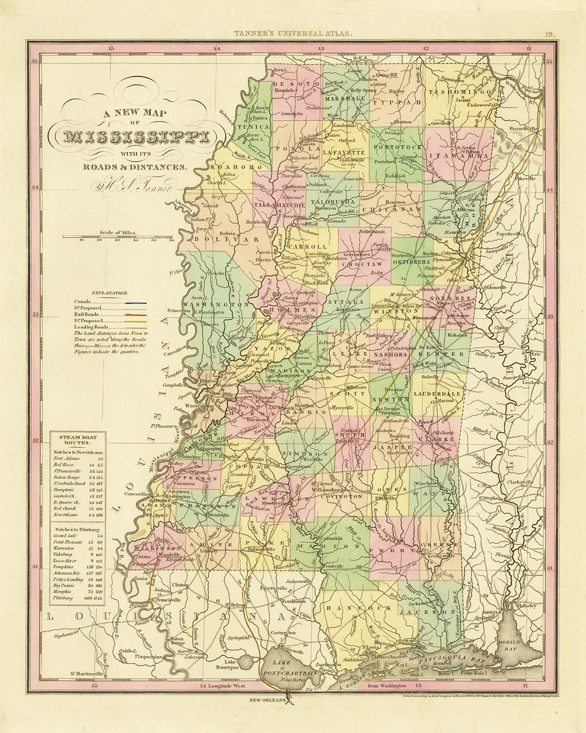
Immerse yourself in the grandeur of the past with this beautifully crafted 1836 map of Mississippi by esteemed cartographer, H. S. Tanner. This vintage piece is not just a map; it's a snapshot of history that vividly showcases Mississippi in its early stages of growth and development. From the burgeoning towns that have now become major cities, to the intricacies of the transportation network of canals, roads, and railroads, the map captures an age of exploration and expansion that shaped the Magnolia State we know today. Its meticulous details even include the distances between key settlements, providing a glimpse into the painstaking work of 19th-century cartography.
Each feature on this map tells a story – the well-trodden roads that guided travelers, the flourishing canals that facilitated commerce, the nascent railroads heralding the onset of the industrial era. It's the perfect collectible for history buffs, map lovers, and Mississippi enthusiasts alike, who will find countless hours of fascination in exploring the beginnings of familiar cities and towns, and tracing the veins of the state's early transport systems. This exquisite map is more than a piece of decor; it's a conversation starter and an insightful look into our shared past.
List of settlements in order of modern day population size:
- Jackson (1821): The state's capital and largest city, Jackson was initially known as LeFleur's Bluff. Named after President Andrew Jackson, it has long been a hub of African-American culture and civil rights history.
- Gulfport (1835): Founded as a harbor city, Gulfport has grown into Mississippi's second-largest city. Its significance as a port city is integral to the state's economic history.
- Southaven (1825): Situated in DeSoto County, Southaven was an early rural settlement that has grown into a populous city. Its proximity to the Mississippi River made it significant in trade.
- Biloxi (1699): One of the oldest European settlements in the United States, Biloxi served as the capital of French Louisiana. Its vibrant history makes it a popular tourist destination.
- Meridian (1833): Founded as a railroad town, Meridian was a major strategic location during the Civil War. Its rich history can still be seen in the architecture today.
- Tupelo (1830): Renowned as the birthplace of Elvis Presley, Tupelo's rich history is evident in the Chickasaw Village and Fort site, and the Tupelo National Battlefield.
- Greenville (1824): Named after Revolutionary War hero Nathanael Greene, Greenville became a major cotton producer and played a significant role in the Mississippi Delta's Blues music heritage.
- Olive Branch (1836): Established as a postal station, Olive Branch has seen rapid growth due to its strategic location near the border of Tennessee.
- Horn Lake (1810): Initially settled by English and Scottish immigrants, it was an important transportation hub due to its location on the Mississippi River.
- Pearl (1820): Named for the Pearl River which runs along its eastern boundary, this city was a key player in the state's early transportation and trade.
- Madison (1856): Founded as Madison Station, the city was an important site on the Illinois Central Railroad.
- Brandon (1828): Named after the first wife of Gerard C. Brandon, the state's first native-born governor, it was a key center for education in Mississippi.
- Starkville (1831): The home of Mississippi State University, one of the state's land grant institutions, Starkville was originally called Boardtown.
- Oxford (1835): Known as the home of the University of Mississippi, Oxford was named after the British university city to attract educators.
- Greenwood (1830): Known as the "Cotton Capital of the World," Greenwood played a significant role in the state's agricultural history.
- Laurel (1882): Founded as a lumber town, Laurel's sawmills supplied the world with yellow pine.
- Grenada (1836): Named after the Spanish province, Grenada was a key site for Southern troops during the Civil War.
- Pascagoula (1720): Known as the "Flagship City," Pascagoula is famous for its shipbuilding industry.
Notable Features:
- Mississippi River: The most significant river in the state, its importance for transportation and trade in the 19th century cannot be overstated.
- Natchez Trace Parkway: This historic forest trail extends 444 miles from Natchez, Mississippi, to Nashville, Tennessee, and was an important wilderness road during the 1800s.
- Vicksburg National Military Park: The site of the Civil War's Battle of Vicksburg in 1863, it is a popular historical destination.
- The Mississippi Delta: Known as "The Most Southern Place on Earth," the Delta is known for its rich soil and has been a hub for agriculture and Blues music.
Historical Events (1810-1840):
- The Battle of Ackia (1836): This battle during the Chickasaw Wars took place near modern-day Tupelo, where the Chickasaw defeated the French and their Choctaw allies.
- The Trail of Tears (1831-1838): This series of forced relocations of Native American nations, including the Choctaw from Mississippi, was a tragic event in American history.
- The Formation of the State (1817): Mississippi officially became the 20th state of the Union on December 10, 1817.
Please double check the images to make sure that a specific town or place is shown on this map. You can also get in touch and ask us to check the map for you.
This map looks great at all sizes, but it looks even better when printed large.
I can create beautiful, large prints of this map up to 100in (254cm). Please get in touch if you're looking for larger, customised or different framing options.
The model in the listing images is holding the 16x20in (40.5x51cm) version of this map.
The fifth listing image shows an example of my map personalisation service.
If you’re looking for something slightly different, check out my main collection of USA and North America maps.
Please contact me to check if a certain location, landmark or feature is shown on this map.
This would make a wonderful birthday, Christmas, Father's Day, work leaving, anniversary or housewarming gift for someone from the areas covered by this map.
This map is available as a giclée print on acid free archival matte paper, or you can buy it framed. The frame is a nice, simple black frame that suits most aesthetics. Please get in touch if you'd like a different frame colour or material. My frames are glazed with super-clear museum-grade acrylic (perspex/acrylite), which is significantly less reflective than glass, safer, and will always arrive in perfect condition.
This map is also available as a float framed canvas, sometimes known as a shadow gap framed canvas or canvas floater. The map is printed on artist's cotton canvas and then stretched over a handmade box frame. We then "float" the canvas inside a wooden frame, which is available in a range of colours (black, dark brown, oak, antique gold and white). This is a wonderful way to present a map without glazing in front. See some examples of float framed canvas maps and explore the differences between my different finishes.
For something truly unique, this map is also available in "Unique 3D", our trademarked process that dramatically transforms the map so that it has a wonderful sense of depth. We combine the original map with detailed topography and elevation data, so that mountains and the terrain really "pop". For more info and examples of 3D maps, check my Unique 3D page.
Many of our maps and art prints are chosen as thoughtful gifts for homes, offices, studies and meaningful places.
Choose a framed option for the easiest ready-to-hang gift, or choose an unframed print if the recipient may prefer to select their own frame.
We make orders locally in 23 countries around the world, so gifts can often be produced close to the recipient. This helps them arrive faster, travel more safely, and avoid customs or import duty surprises.
- We can deliver directly to the recipient
- Framed pieces arrive ready to hang
- Unframed prints are carefully packed in a strong protective tube
- Almost every order is made locally, for faster, safer gifting
- 90-day returns give the recipient time to decide
If you are not sure what to choose, please contact us. We can help you pick the right map, size, finish or delivery option.
Most orders are made locally and delivered in around 2–3 working days, depending on the product, size and destination.
We print and frame maps and artwork in 23 countries around the world, so your order is usually made close to you or your recipient. That means faster delivery, less time in transit, and no customs or import duty surprises.
Personalised and customised pieces usually take an extra 1–2 working days, because we prepare your design and send it to you for approval before printing.
Very large framed orders can take a little longer, as they need extra care in production and delivery.
Every order is carefully packaged: unframed prints are sent in a strong protective tube, while framed pieces are securely packed with protective materials around the frame.
If you need your order by a particular date, please contact us before ordering. We’ll check the best production route and delivery option for your location.
Express delivery is available at checkout for most countries. Next-day delivery is available in the UK, US, Singapore and the UAE.
Your order is covered by our 90-day returns policy and 10-year guarantee.
Our standard frame is a gallery-style black ash hardwood frame, with a simple, modern look. It is approximately 20mm (0.8in) wide. You can also view some lovely customer photos of framed maps and art.
We use super-clear acrylic glazing, also known as Perspex or Acrylite, instead of traditional glass. It is lighter, safer, and has lower reflectivity, giving the artwork a clearer, cleaner appearance.
Six standard frame colours are available at no extra cost: black, dark brown, dark grey, oak, white, and antique gold. Custom framing and mounting/matting is also available for customers looking for something more specific.
Most maps, art prints, and illustrations are also available as a framed canvas. We use matte cotton canvas, stretch it over a sustainably sourced wooden box frame, and then float the piece within a wooden outer frame. The finished result is beautifully presented, with no glazing between you and the artwork.
All frames are supplied ready to hang, with either string or brackets fitted to the back. Very large frames will include heavy-duty hanging plates and/or a mounting baton. If you have any questions, please get in touch.
We can also supply old maps and artwork on canvas, foam board, cotton rag, and other materials.
If you would prefer to frame your map or artwork yourself, please read our size guide before ordering.
My maps are extremely high quality reproductions of original maps.
I source original, rare maps from libraries, auction houses and private collections around the world, restore them at my London workshop, and then use specialist giclée inks and printers to create beautiful maps that look even better than the original.
My maps are printed on acid-free archival matte (not glossy) paper that feels very high quality and almost like card. In technical terms the paper weight/thickness is 10mil/200gsm. It's perfect for framing.
I print with Epson ultrachrome giclée UV fade resistant pigment inks - some of the best inks you can find.
I can also make maps on canvas, cotton rag and other exotic materials.
Learn more about The Unique Maps Co.
Map personalisation
If you're looking for the perfect anniversary or housewarming gift, I can personalise your map to make it truly unique. For example, I can add a short message, or highlight an important location, or add your family's coat of arms.
The options are almost infinite. Please see my map personalisation page for some wonderful examples of what's possible.
To order a personalised map, select "personalise your map" before adding it to your basket.
Get in touch if you're looking for more complex customisations and personalisations.
Map ageing
I have been asked hundreds of times over the years by customers if they could buy a map that looks even older.
Well, now you can, by selecting Aged before you add a map to your basket.
All the product photos you see on this page show the map in its Original form. This is what the map looks like today.
If you select Aged, I will age your map by hand, using a special and unique process developed through years of studying old maps, talking to researchers to understand the chemistry of aging paper, and of course... lots of practice!
If you're unsure, stick to the Original colour of the map. If you want something a bit darker and older looking, go for Aged.
If you are not happy with your order for any reason, contact me and I'll get it fixed ASAP, free of charge. Please see my returns and refund policy for more information.
I am very confident you will like your restored map or art print. I have been doing this since 1984. I'm a 5-star Etsy seller. I have sold tens of thousands of maps and art prints and have over 5,000 real 5-star reviews. My work has been featured in interior design magazines, on the BBC, and on the walls of dozens of 5-star hotels.
I use a unique process to restore maps and artwork that is massively time consuming and labour intensive. Hunting down the original maps and illustrations can take months. I use state of the art and eye-wateringly expensive technology to scan and restore them. As a result, I guarantee my maps and art prints are a cut above the rest. I stand by my products and will always make sure you're 100% happy with what you receive.
Almost all of my maps and art prints look amazing at large sizes (200cm, 6.5ft+) and I can frame and deliver them to you as well, via special oversized courier. Contact me to discuss your specific needs.
Or try searching for something!


