


Rare Old Map of the Indian Ocean by Du Val, 1665: East Indies, Dutch Voyages, Early Australia
20% off 2 — 33% off 3
Add any two eligible items to your bag to receive 20% off. Add a third and it will be complimentary (equivalent to 33% off when purchasing three).
No code needed — the offer applies automatically at checkout.
Valid on all standard maps and fine art prints. You can mix and match any designs.
If you’d like to ship items to multiple addresses, please contact us before placing your order.
Custom and bespoke commissions are excluded.
Contact us if you have any questions
 Designed in London Made in Canada
Designed in London • Made in Canada
Designed in London Made in Canada
Designed in London • Made in Canada

Restored from the original 1665 map and printed to museum-grade archival standards. Read the story behind this map
Choose your size
Choose your finish


(More info)
Gift message & custom finish

If you want to add a gift message, or a finish (jigsaw, aluminium board, etc.) that is not available here, please request it in the "order note" when you check out.
Every order is custom made, so if you need the size adjusted slightly, or printed on an unusual material, just let us know. We've done thousands of custom orders over the years, so there's (almost) nothing we can't manage.
You can also contact us before you order, if you prefer!

- Made locally for fast, safe delivery
- No import duty or hidden fees
- Need advice? Call us or message on WhatsApp
Own a piece of history
8,000+ five-star reviews


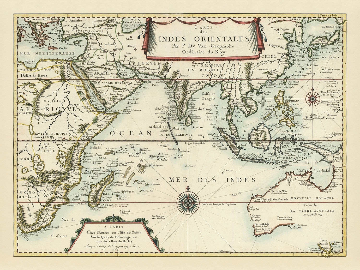
Step into the fascinating world of 17th-century exploration with Pierre Du Val’s masterwork, Carte des Indes Orientales . . . 1665. This...
Continue readingStep into the fascinating world of 17th-century exploration with Pierre Du Val’s masterwork, Carte des Indes Orientales . . . 1665. This extraordinary map, crafted by one of France’s most esteemed cartographers, encapsulates the very spirit of the Age of Discovery. Du Val’s meticulous research and access to the latest Dutch and French sources are evident in every detail, offering a sweeping vision of the Indian Ocean and its surrounding lands at a time when European curiosity and ambition were redrawing the boundaries of the known world.
The map’s scope is breathtaking, stretching from the eastern shores of Africa across the Indian Ocean to the mysterious lands of Australia, Japan, and Maritime Southeast Asia. It is a visual record of both political and physical geography, highlighting the routes and discoveries of Dutch explorers along the coasts of Australia and New Guinea. Rich annotations mark the first European encounters with these lands, immortalizing the voyages of the Duyfken, Endracht, Arnhem, and other legendary ships. Each label is a testament to the era’s relentless pursuit of knowledge and the fierce competition among European powers to chart the unknown.
Du Val’s artistry is unmistakable in the map’s restrained yet sophisticated embellishments. Elegant compass roses guide the viewer’s eye across the seas, while ornamental cartouches—most notably the draped title at the top center—lend a sense of refinement and grandeur. The hydrography is rendered with exquisite care, from the “quilted” regularity of the Maldives to the winding courses of the Ganges and Nile. In the upper right, a delicately drawn Great Wall of China hints at the mapmaker’s appreciation for the marvels of the East, while the Montagnes de la Lune anchor the European imagination of Africa’s mysterious interior.
The map’s historical significance is profound. It captures a pivotal moment when European understanding of the wider world was expanding rapidly, yet still marked by gaps and mythologies. Australia, labeled as “Novvelle Holande partie de la Terre Australe,” appears with a remarkably complete outline for its time, though its interior remains a blank canvas. Dutch discoveries are meticulously recorded, from the Houtmans Abrolhos to Terre d’Antoine Diemens (Tasmania), alongside references to the earliest English shipwreck, the Trial. These details not only illuminate the routes of intrepid mariners but also reveal the competitive secrecy and occasional misinformation that shaped early cartography.
For the discerning collector, Du Val’s Carte des Indes Orientales is more than a map—it is a tangible link to the golden age of exploration and the evolving art of mapmaking. Its blend of scientific precision, artistic elegance, and historical annotation make it a prized artifact for anyone captivated by the stories of discovery that shaped our modern world. Whether displayed as a centerpiece or studied for its wealth of detail, this map stands as a testament to the enduring allure of the unknown and the brilliance of those who dared to chart it.
Countries and regions on this map
- Africa (particularly Eastern and Southern Africa)
- Madagascar
- Arabian Peninsula
- Persia (Iran)
- Mogul Empire (India)
- Ceylon (Sri Lanka)
- China
- Japan
- Korea
- Maritime Southeast Asia (including the Malay Peninsula, Sumatra, Java, Borneo, Philippines, and the Indonesian Archipelago)
- Australia (labeled as "Novvelle Holande partie de la Terre Australe")
- New Guinea
- Tasmania ("Terre d’Antoine Diemens")
Notable Features & Landmarks
- Decorative title cartouche at the top center, presented on an elegantly draped cloth
- Compass roses placed at various points across the ocean, providing orientation
- Ornamental trapezoid in the bottom left corner with the mapmaker’s address and date
- Detailed depiction of the Great Wall of China in the upper right corner
- Clearly labeled historical notes about Dutch voyages and encounters with Australia, such as "Terre d'Arnems," "Terre de Wits," "Houtmans Abrolhos," "Terre d'Edels," "Terre de Leuuin," "Terre d'Antoine Diemens," and "Trial"
- Rivers prominently depicted, including the Nile in Africa (originating from two lakes near the Montagnes de la Lune) and the Ganges in South Asia
- Numerous islands, archipelagos, and shoals, including the Maldives, depicted with detailed and regular patterns
- Historical annotations referencing Dutch navigators and ships, including Dirk Hartog, Abel Tasman, Pieter Nuyts, and others
- Labeling of the Mogul Empire in South Asia
- Labeling of the VOC (Dutch East India Company) exploration routes and discoveries along the Australian coast
Historical and design context
- Created by Pierre Du Val, a prominent French cartographer known for his detailed and elegantly decorated maps
- First published in 1665, with a second edition in 1677
- Reflects European geographic knowledge and exploration in the late 17th century, particularly Dutch maritime exploration and encounters with Australia
- Incorporates information from Dutch East India Company (VOC) charts and maps by Melchisédech Thévenot, notably for East Asia
- Elegantly decorated with restrained yet sophisticated embellishments, including compass roses, ornamental cartouches, and decorative drapery for the title
- Themes include maritime exploration, early European contact with Australia, geographic knowledge of Asia and Africa, hydrography, and cartographic artistry
- Captures a pivotal moment when European understanding of the wider world was expanding rapidly, yet still marked by gaps and mythologies
Please double check the images to make sure that a specific town or place is shown on this map. You can also get in touch and ask us to check the map for you.
This map looks great at every size, but I always recommend going for a larger size if you have space. That way you can easily make out all of the details.
This map looks amazing at sizes all the way up to 90in (230cm). If you are looking for a larger map, please get in touch.
The model in the listing images is holding the 18x24in (45x60cm) version of this map.
The fifth listing image shows an example of my map personalisation service.
If you’re looking for something slightly different, check out my collection of the best old maps to see if something else catches your eye.
Please contact me to check if a certain location, landmark or feature is shown on this map.
This would make a wonderful birthday, Christmas, Father's Day, work leaving, anniversary or housewarming gift for someone from the areas covered by this map.
This map is available as a giclée print on acid free archival matte paper, or you can buy it framed. The frame is a nice, simple black frame that suits most aesthetics. Please get in touch if you'd like a different frame colour or material. My frames are glazed with super-clear museum-grade acrylic (perspex/acrylite), which is significantly less reflective than glass, safer, and will always arrive in perfect condition.
This map is also available as a float framed canvas, sometimes known as a shadow gap framed canvas or canvas floater. The map is printed on artist's cotton canvas and then stretched over a handmade box frame. We then "float" the canvas inside a wooden frame, which is available in a range of colours (black, dark brown, oak, antique gold and white). This is a wonderful way to present a map without glazing in front. See some examples of float framed canvas maps and explore the differences between my different finishes.
For something truly unique, this map is also available in "Unique 3D", our trademarked process that dramatically transforms the map so that it has a wonderful sense of depth. We combine the original map with detailed topography and elevation data, so that mountains and the terrain really "pop". For more info and examples of 3D maps, check my Unique 3D page.
Step into the fascinating world of 17th-century exploration with Pierre Du Val’s masterwork, Carte des Indes Orientales . . . 1665. This extraordinary map, crafted by one of France’s most esteemed cartographers, encapsulates the very spirit of the Age of Discovery. Du Val’s meticulous research and access to the latest Dutch and French sources are evident in every detail, offering a sweeping vision of the Indian Ocean and its surrounding lands at a time when European curiosity and ambition were redrawing the boundaries of the known world.
The map’s scope is breathtaking, stretching from the eastern shores of Africa across the Indian Ocean to the mysterious lands of Australia, Japan, and Maritime Southeast Asia. It is a visual record of both political and physical geography, highlighting the routes and discoveries of Dutch explorers along the coasts of Australia and New Guinea. Rich annotations mark the first European encounters with these lands, immortalizing the voyages of the Duyfken, Endracht, Arnhem, and other legendary ships. Each label is a testament to the era’s relentless pursuit of knowledge and the fierce competition among European powers to chart the unknown.
Du Val’s artistry is unmistakable in the map’s restrained yet sophisticated embellishments. Elegant compass roses guide the viewer’s eye across the seas, while ornamental cartouches—most notably the draped title at the top center—lend a sense of refinement and grandeur. The hydrography is rendered with exquisite care, from the “quilted” regularity of the Maldives to the winding courses of the Ganges and Nile. In the upper right, a delicately drawn Great Wall of China hints at the mapmaker’s appreciation for the marvels of the East, while the Montagnes de la Lune anchor the European imagination of Africa’s mysterious interior.
The map’s historical significance is profound. It captures a pivotal moment when European understanding of the wider world was expanding rapidly, yet still marked by gaps and mythologies. Australia, labeled as “Novvelle Holande partie de la Terre Australe,” appears with a remarkably complete outline for its time, though its interior remains a blank canvas. Dutch discoveries are meticulously recorded, from the Houtmans Abrolhos to Terre d’Antoine Diemens (Tasmania), alongside references to the earliest English shipwreck, the Trial. These details not only illuminate the routes of intrepid mariners but also reveal the competitive secrecy and occasional misinformation that shaped early cartography.
For the discerning collector, Du Val’s Carte des Indes Orientales is more than a map—it is a tangible link to the golden age of exploration and the evolving art of mapmaking. Its blend of scientific precision, artistic elegance, and historical annotation make it a prized artifact for anyone captivated by the stories of discovery that shaped our modern world. Whether displayed as a centerpiece or studied for its wealth of detail, this map stands as a testament to the enduring allure of the unknown and the brilliance of those who dared to chart it.
Countries and regions on this map
- Africa (particularly Eastern and Southern Africa)
- Madagascar
- Arabian Peninsula
- Persia (Iran)
- Mogul Empire (India)
- Ceylon (Sri Lanka)
- China
- Japan
- Korea
- Maritime Southeast Asia (including the Malay Peninsula, Sumatra, Java, Borneo, Philippines, and the Indonesian Archipelago)
- Australia (labeled as "Novvelle Holande partie de la Terre Australe")
- New Guinea
- Tasmania ("Terre d’Antoine Diemens")
Notable Features & Landmarks
- Decorative title cartouche at the top center, presented on an elegantly draped cloth
- Compass roses placed at various points across the ocean, providing orientation
- Ornamental trapezoid in the bottom left corner with the mapmaker’s address and date
- Detailed depiction of the Great Wall of China in the upper right corner
- Clearly labeled historical notes about Dutch voyages and encounters with Australia, such as "Terre d'Arnems," "Terre de Wits," "Houtmans Abrolhos," "Terre d'Edels," "Terre de Leuuin," "Terre d'Antoine Diemens," and "Trial"
- Rivers prominently depicted, including the Nile in Africa (originating from two lakes near the Montagnes de la Lune) and the Ganges in South Asia
- Numerous islands, archipelagos, and shoals, including the Maldives, depicted with detailed and regular patterns
- Historical annotations referencing Dutch navigators and ships, including Dirk Hartog, Abel Tasman, Pieter Nuyts, and others
- Labeling of the Mogul Empire in South Asia
- Labeling of the VOC (Dutch East India Company) exploration routes and discoveries along the Australian coast
Historical and design context
- Created by Pierre Du Val, a prominent French cartographer known for his detailed and elegantly decorated maps
- First published in 1665, with a second edition in 1677
- Reflects European geographic knowledge and exploration in the late 17th century, particularly Dutch maritime exploration and encounters with Australia
- Incorporates information from Dutch East India Company (VOC) charts and maps by Melchisédech Thévenot, notably for East Asia
- Elegantly decorated with restrained yet sophisticated embellishments, including compass roses, ornamental cartouches, and decorative drapery for the title
- Themes include maritime exploration, early European contact with Australia, geographic knowledge of Asia and Africa, hydrography, and cartographic artistry
- Captures a pivotal moment when European understanding of the wider world was expanding rapidly, yet still marked by gaps and mythologies
Please double check the images to make sure that a specific town or place is shown on this map. You can also get in touch and ask us to check the map for you.
This map looks great at every size, but I always recommend going for a larger size if you have space. That way you can easily make out all of the details.
This map looks amazing at sizes all the way up to 90in (230cm). If you are looking for a larger map, please get in touch.
The model in the listing images is holding the 18x24in (45x60cm) version of this map.
The fifth listing image shows an example of my map personalisation service.
If you’re looking for something slightly different, check out my collection of the best old maps to see if something else catches your eye.
Please contact me to check if a certain location, landmark or feature is shown on this map.
This would make a wonderful birthday, Christmas, Father's Day, work leaving, anniversary or housewarming gift for someone from the areas covered by this map.
This map is available as a giclée print on acid free archival matte paper, or you can buy it framed. The frame is a nice, simple black frame that suits most aesthetics. Please get in touch if you'd like a different frame colour or material. My frames are glazed with super-clear museum-grade acrylic (perspex/acrylite), which is significantly less reflective than glass, safer, and will always arrive in perfect condition.
This map is also available as a float framed canvas, sometimes known as a shadow gap framed canvas or canvas floater. The map is printed on artist's cotton canvas and then stretched over a handmade box frame. We then "float" the canvas inside a wooden frame, which is available in a range of colours (black, dark brown, oak, antique gold and white). This is a wonderful way to present a map without glazing in front. See some examples of float framed canvas maps and explore the differences between my different finishes.
For something truly unique, this map is also available in "Unique 3D", our trademarked process that dramatically transforms the map so that it has a wonderful sense of depth. We combine the original map with detailed topography and elevation data, so that mountains and the terrain really "pop". For more info and examples of 3D maps, check my Unique 3D page.
Many of our maps and art prints are chosen as thoughtful gifts for homes, offices, studies and meaningful places.
Choose a framed option for the easiest ready-to-hang gift, or choose an unframed print if the recipient may prefer to select their own frame.
We make orders locally in 23 countries around the world, so gifts can often be produced close to the recipient. This helps them arrive faster, travel more safely, and avoid customs or import duty surprises.
- We can deliver directly to the recipient
- Framed pieces arrive ready to hang
- Unframed prints are carefully packed in a strong protective tube
- Almost every order is made locally, for faster, safer gifting
- 90-day returns give the recipient time to decide
If you are not sure what to choose, please contact us. We can help you pick the right map, size, finish or delivery option.
Most orders are made locally and delivered in around 2–3 working days, depending on the product, size and destination.
We print and frame maps and artwork in 23 countries around the world, so your order is usually made close to you or your recipient. That means faster delivery, less time in transit, and no customs or import duty surprises.
Personalised and customised pieces usually take an extra 1–2 working days, because we prepare your design and send it to you for approval before printing.
Very large framed orders can take a little longer, as they need extra care in production and delivery.
Every order is carefully packaged: unframed prints are sent in a strong protective tube, while framed pieces are securely packed with protective materials around the frame.
If you need your order by a particular date, please contact us before ordering. We’ll check the best production route and delivery option for your location.
Express delivery is available at checkout for most countries. Next-day delivery is available in the UK, US, Singapore and the UAE.
Your order is covered by our 90-day returns policy and 10-year guarantee.
Our standard frame is a gallery-style black ash hardwood frame, with a simple, modern look. It is approximately 20mm (0.8in) wide. You can also view some lovely customer photos of framed maps and art.
We use super-clear acrylic glazing, also known as Perspex or Acrylite, instead of traditional glass. It is lighter, safer, and has lower reflectivity, giving the artwork a clearer, cleaner appearance.
Six standard frame colours are available at no extra cost: black, dark brown, dark grey, oak, white, and antique gold. Custom framing and mounting/matting is also available for customers looking for something more specific.
Most maps, art prints, and illustrations are also available as a framed canvas. We use matte cotton canvas, stretch it over a sustainably sourced wooden box frame, and then float the piece within a wooden outer frame. The finished result is beautifully presented, with no glazing between you and the artwork.
All frames are supplied ready to hang, with either string or brackets fitted to the back. Very large frames will include heavy-duty hanging plates and/or a mounting baton. If you have any questions, please get in touch.
We can also supply old maps and artwork on canvas, foam board, cotton rag, and other materials.
If you would prefer to frame your map or artwork yourself, please read our size guide before ordering.
My maps are extremely high quality reproductions of original maps.
I source original, rare maps from libraries, auction houses and private collections around the world, restore them at my London workshop, and then use specialist giclée inks and printers to create beautiful maps that look even better than the original.
My maps are printed on acid-free archival matte (not glossy) paper that feels very high quality and almost like card. In technical terms the paper weight/thickness is 10mil/200gsm. It's perfect for framing.
I print with Epson ultrachrome giclée UV fade resistant pigment inks - some of the best inks you can find.
I can also make maps on canvas, cotton rag and other exotic materials.
Learn more about The Unique Maps Co.
Map personalisation
If you're looking for the perfect anniversary or housewarming gift, I can personalise your map to make it truly unique. For example, I can add a short message, or highlight an important location, or add your family's coat of arms.
The options are almost infinite. Please see my map personalisation page for some wonderful examples of what's possible.
To order a personalised map, select "personalise your map" before adding it to your basket.
Get in touch if you're looking for more complex customisations and personalisations.
Map ageing
I have been asked hundreds of times over the years by customers if they could buy a map that looks even older.
Well, now you can, by selecting Aged before you add a map to your basket.
All the product photos you see on this page show the map in its Original form. This is what the map looks like today.
If you select Aged, I will age your map by hand, using a special and unique process developed through years of studying old maps, talking to researchers to understand the chemistry of aging paper, and of course... lots of practice!
If you're unsure, stick to the Original colour of the map. If you want something a bit darker and older looking, go for Aged.
If you are not happy with your order for any reason, contact me and I'll get it fixed ASAP, free of charge. Please see my returns and refund policy for more information.
I am very confident you will like your restored map or art print. I have been doing this since 1984. I'm a 5-star Etsy seller. I have sold tens of thousands of maps and art prints and have over 5,000 real 5-star reviews. My work has been featured in interior design magazines, on the BBC, and on the walls of dozens of 5-star hotels.
I use a unique process to restore maps and artwork that is massively time consuming and labour intensive. Hunting down the original maps and illustrations can take months. I use state of the art and eye-wateringly expensive technology to scan and restore them. As a result, I guarantee my maps and art prints are a cut above the rest. I stand by my products and will always make sure you're 100% happy with what you receive.
Almost all of my maps and art prints look amazing at large sizes (200cm, 6.5ft+) and I can frame and deliver them to you as well, via special oversized courier. Contact me to discuss your specific needs.
Or try searching for something!


