


Rare Old Spheroidal Map of Europe & the Arctic by Garnier, 1860
The Collector’s Offer
Choose two eligible works and receive 20% off both. Choose three and the lowest-priced one is complimentary, a maximum saving of 33%.
Mix and match eligible standard maps and fine-art prints. No code is required; the offer is applied automatically at checkout.
Standard made-to-order configurations are included. Bespoke sizes, personalised designs and commissioned work are excluded.
Need delivery to different addresses? Contact us before ordering.The Collector’s Offer
Choose two eligible works and receive 20% off both. Choose three and the lowest-priced one is complimentary, a maximum saving of 33%.
Mix and match eligible standard maps and fine-art prints. No code is required; the offer is applied automatically at checkout.
Standard made-to-order configurations are included. Bespoke sizes, personalised designs and commissioned work are excluded.
Need delivery to different addresses? Contact us before ordering. Designed in London Made in Canada
Designed in London • Made in Canada
Designed in London Made in Canada
Designed in London • Made in Canada

Restored from the original 1860 map and printed to museum-grade archival standards. Read the story behind this map
Choose your size
Choose your finish


(More info)
Gift message & custom finish

If you want to add a gift message, or a finish (jigsaw, aluminium board, etc.) that is not available here, please request it in the "order note" when you check out.
Every order is custom made, so if you need the size adjusted slightly, or printed on an unusual material, just let us know. We've done thousands of custom orders over the years, so there's (almost) nothing we can't manage.
You can also contact us before you order, if you prefer!

- Made locally for fast, safe delivery
- No import duty or hidden fees
- Need advice? Call us or message on WhatsApp
Own a piece of history
8,000+ five-star reviews


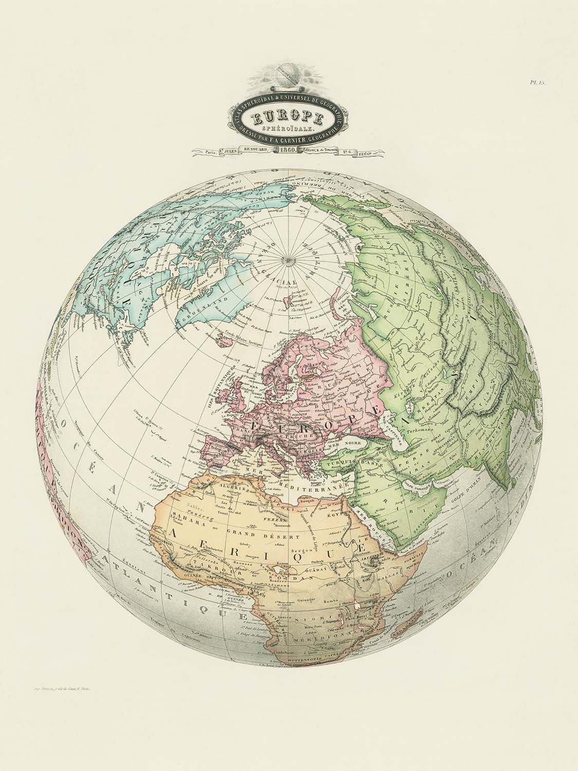
Step into the refined world of 19th-century cartography with "Europe Spheroidale," an exquisite map crafted by the esteemed geographer F. A. Garnier...
Continue readingStep into the refined world of 19th-century cartography with "Europe Spheroidale," an exquisite map crafted by the esteemed geographer F. A. Garnier in 1860. This remarkable work, published by V. Jules Renouard, stands as a testament to the scientific curiosity and artistic mastery of its era. Garnier’s meticulous attention to detail is evident in every aspect of the map, from the precision of its boundaries to the elegant hand-coloring that brings the political landscape of Europe and its neighboring regions vividly to life. The map’s original French title, "Europe Spheroidale," reflects its central theme: a celebration of the spherical nature of the Earth, a concept that was gaining renewed appreciation in the age of exploration and discovery.
At the heart of this map lies a compelling visual narrative that extends beyond Europe, encompassing the Arctic, parts of North Africa, and Western Asia. The inclusion of these regions offers a sweeping perspective on the interconnectedness of continents during a time when borders and empires were in flux. Major rivers such as the Danube and Rhine, as well as prominent mountain ranges like the Alps and Pyrenees, are rendered with clarity and accuracy, inviting the viewer to trace the natural features that have shaped the course of history. The careful delineation of political boundaries provides a fascinating snapshot of the geopolitical landscape on the eve of profound transformation.
A hallmark of Garnier’s artistry is the decorative cartouche that graces the top of the map, featuring a globe and the inscription "Sphéricité de la terre." This elegant embellishment not only underscores the scientific spirit of the period but also adds a touch of sophistication to the composition. The hand-colored details further enhance the map’s visual appeal, with each country and region distinguished by subtle hues that evoke the grandeur of antique atlases. The grid of latitude and longitude lines speaks to the era’s commitment to precision and navigational utility, making this map as functional as it is beautiful.
The map’s design is a masterclass in mid-19th-century cartographic style, blending artistry with empirical rigor. The clear labeling of seas, oceans, and landforms is complemented by the inclusion of both familiar and lesser-known regions, such as the British Isles, the Iberian and Balkan peninsulas, and the far reaches of the Ottoman Empire. This comprehensive approach reflects Garnier’s dedication to providing a holistic view of the world, one that balances political realities with the enduring features of the natural landscape. The Arctic region, prominently displayed at the top, hints at the era’s fascination with exploration and the mysteries that lay beyond the known world.
Owning "Europe Spheroidale" is to possess a piece of history—a window into a time when the boundaries of knowledge were expanding as rapidly as the borders on the map itself. This map is not merely a geographical document; it is a work of art that captures the intellectual and aesthetic values of its age. Whether displayed in a study, library, or gallery, Garnier’s masterpiece offers both a striking visual statement and a rich source of historical insight, making it an essential addition to any discerning collection of antique maps.
Countries and regions on this map
- Europe
- Arctic region
- Northern Africa
- Western Asia
- Scandinavia
- British Isles
- Iberian Peninsula
- Italian Peninsula
- Balkan Peninsula
- Eastern Europe
- Central Europe
- Western Europe
- Russia (European part)
- Ottoman Empire (European and Asian parts)
- France
- Spain
- Portugal
- Italy
- Germany (various states and principalities)
- Austria (Austrian Empire)
- Switzerland
- Netherlands
- Belgium
- Denmark
- Sweden
- Norway
- Greece
- Turkey (Ottoman Empire)
- Egypt (partially visible)
- Algeria (partially visible)
- Morocco (partially visible)
- Tunisia (partially visible)
Notable Features & Landmarks
- Decorative cartouche at the top with globe illustration and inscription "Sphéricité de la terre."
- Clearly delineated political boundaries, highlighted by hand coloring.
- Detailed labeling of seas and oceans, such as the Mediterranean Sea, Atlantic Ocean, and Arctic Ocean.
- Prominent mountain ranges, including clearly labeled Alps and Pyrenees.
- Arctic region prominently displayed at the top of the map.
- Detailed labeling of major rivers and bodies of water, such as the Danube River, Rhine River, and Black Sea.
- Latitude and longitude grid lines clearly marked, emphasizing scientific accuracy and navigational utility.
- Inclusion of parts of Northern Africa and Western Asia, clearly labeled and colored.
Historical and design context
- Created by F. A. Garnier, a geographer known for detailed and scientifically informed cartographic works.
- Published by V. Jules Renouard in 1860.
- Hand-colored, detailed political map, typical of mid-19th-century cartographic art, emphasizing clarity, precision, and aesthetic appeal.
- Reflects the scientific and exploratory spirit of the 19th century, providing insights into the geopolitical boundaries and geographical knowledge of the era.
- Focused primarily on Europe, but also includes surrounding regions such as parts of Africa, Asia, and the Arctic region.
- Includes a decorative cartouche at the top with a globe illustration, emphasizing the spherical shape of the Earth.
- Provides a fascinating snapshot of the geopolitical landscape on the eve of profound transformation.
Please double check the images to make sure that a specific town or place is shown on this map. You can also get in touch and ask us to check the map for you.
This map looks great at every size, but I always recommend going for a larger size if you have space. That way you can easily make out all of the details.
This map looks amazing at sizes all the way up to 70in (180cm). If you are looking for a larger map, please get in touch.
The model in the listing images is holding the 18x24in (45x60cm) version of this map.
The fifth listing image shows an example of my map personalisation service.
If you’re looking for something slightly different, check out my collection of the best old maps to see if something else catches your eye.
Please contact me to check if a certain location, landmark or feature is shown on this map.
This would make a wonderful birthday, Christmas, Father's Day, work leaving, anniversary or housewarming gift for someone from the areas covered by this map.
This map is available as a giclée print on acid free archival matte paper, or you can buy it framed. The frame is a nice, simple black frame that suits most aesthetics. Please get in touch if you'd like a different frame colour or material. My frames are glazed with super-clear museum-grade acrylic (perspex/acrylite), which is significantly less reflective than glass, safer, and will always arrive in perfect condition.
This map is also available as a float framed canvas, sometimes known as a shadow gap framed canvas or canvas floater. The map is printed on artist's cotton canvas and then stretched over a handmade box frame. We then "float" the canvas inside a wooden frame, which is available in a range of colours (black, dark brown, oak, antique gold and white). This is a wonderful way to present a map without glazing in front. See some examples of float framed canvas maps and explore the differences between my different finishes.
For something truly unique, this map is also available in "Unique 3D", our trademarked process that dramatically transforms the map so that it has a wonderful sense of depth. We combine the original map with detailed topography and elevation data, so that mountains and the terrain really "pop". For more info and examples of 3D maps, check my Unique 3D page.
Step into the refined world of 19th-century cartography with "Europe Spheroidale," an exquisite map crafted by the esteemed geographer F. A. Garnier in 1860. This remarkable work, published by V. Jules Renouard, stands as a testament to the scientific curiosity and artistic mastery of its era. Garnier’s meticulous attention to detail is evident in every aspect of the map, from the precision of its boundaries to the elegant hand-coloring that brings the political landscape of Europe and its neighboring regions vividly to life. The map’s original French title, "Europe Spheroidale," reflects its central theme: a celebration of the spherical nature of the Earth, a concept that was gaining renewed appreciation in the age of exploration and discovery.
At the heart of this map lies a compelling visual narrative that extends beyond Europe, encompassing the Arctic, parts of North Africa, and Western Asia. The inclusion of these regions offers a sweeping perspective on the interconnectedness of continents during a time when borders and empires were in flux. Major rivers such as the Danube and Rhine, as well as prominent mountain ranges like the Alps and Pyrenees, are rendered with clarity and accuracy, inviting the viewer to trace the natural features that have shaped the course of history. The careful delineation of political boundaries provides a fascinating snapshot of the geopolitical landscape on the eve of profound transformation.
A hallmark of Garnier’s artistry is the decorative cartouche that graces the top of the map, featuring a globe and the inscription "Sphéricité de la terre." This elegant embellishment not only underscores the scientific spirit of the period but also adds a touch of sophistication to the composition. The hand-colored details further enhance the map’s visual appeal, with each country and region distinguished by subtle hues that evoke the grandeur of antique atlases. The grid of latitude and longitude lines speaks to the era’s commitment to precision and navigational utility, making this map as functional as it is beautiful.
The map’s design is a masterclass in mid-19th-century cartographic style, blending artistry with empirical rigor. The clear labeling of seas, oceans, and landforms is complemented by the inclusion of both familiar and lesser-known regions, such as the British Isles, the Iberian and Balkan peninsulas, and the far reaches of the Ottoman Empire. This comprehensive approach reflects Garnier’s dedication to providing a holistic view of the world, one that balances political realities with the enduring features of the natural landscape. The Arctic region, prominently displayed at the top, hints at the era’s fascination with exploration and the mysteries that lay beyond the known world.
Owning "Europe Spheroidale" is to possess a piece of history—a window into a time when the boundaries of knowledge were expanding as rapidly as the borders on the map itself. This map is not merely a geographical document; it is a work of art that captures the intellectual and aesthetic values of its age. Whether displayed in a study, library, or gallery, Garnier’s masterpiece offers both a striking visual statement and a rich source of historical insight, making it an essential addition to any discerning collection of antique maps.
Countries and regions on this map
- Europe
- Arctic region
- Northern Africa
- Western Asia
- Scandinavia
- British Isles
- Iberian Peninsula
- Italian Peninsula
- Balkan Peninsula
- Eastern Europe
- Central Europe
- Western Europe
- Russia (European part)
- Ottoman Empire (European and Asian parts)
- France
- Spain
- Portugal
- Italy
- Germany (various states and principalities)
- Austria (Austrian Empire)
- Switzerland
- Netherlands
- Belgium
- Denmark
- Sweden
- Norway
- Greece
- Turkey (Ottoman Empire)
- Egypt (partially visible)
- Algeria (partially visible)
- Morocco (partially visible)
- Tunisia (partially visible)
Notable Features & Landmarks
- Decorative cartouche at the top with globe illustration and inscription "Sphéricité de la terre."
- Clearly delineated political boundaries, highlighted by hand coloring.
- Detailed labeling of seas and oceans, such as the Mediterranean Sea, Atlantic Ocean, and Arctic Ocean.
- Prominent mountain ranges, including clearly labeled Alps and Pyrenees.
- Arctic region prominently displayed at the top of the map.
- Detailed labeling of major rivers and bodies of water, such as the Danube River, Rhine River, and Black Sea.
- Latitude and longitude grid lines clearly marked, emphasizing scientific accuracy and navigational utility.
- Inclusion of parts of Northern Africa and Western Asia, clearly labeled and colored.
Historical and design context
- Created by F. A. Garnier, a geographer known for detailed and scientifically informed cartographic works.
- Published by V. Jules Renouard in 1860.
- Hand-colored, detailed political map, typical of mid-19th-century cartographic art, emphasizing clarity, precision, and aesthetic appeal.
- Reflects the scientific and exploratory spirit of the 19th century, providing insights into the geopolitical boundaries and geographical knowledge of the era.
- Focused primarily on Europe, but also includes surrounding regions such as parts of Africa, Asia, and the Arctic region.
- Includes a decorative cartouche at the top with a globe illustration, emphasizing the spherical shape of the Earth.
- Provides a fascinating snapshot of the geopolitical landscape on the eve of profound transformation.
Please double check the images to make sure that a specific town or place is shown on this map. You can also get in touch and ask us to check the map for you.
This map looks great at every size, but I always recommend going for a larger size if you have space. That way you can easily make out all of the details.
This map looks amazing at sizes all the way up to 70in (180cm). If you are looking for a larger map, please get in touch.
The model in the listing images is holding the 18x24in (45x60cm) version of this map.
The fifth listing image shows an example of my map personalisation service.
If you’re looking for something slightly different, check out my collection of the best old maps to see if something else catches your eye.
Please contact me to check if a certain location, landmark or feature is shown on this map.
This would make a wonderful birthday, Christmas, Father's Day, work leaving, anniversary or housewarming gift for someone from the areas covered by this map.
This map is available as a giclée print on acid free archival matte paper, or you can buy it framed. The frame is a nice, simple black frame that suits most aesthetics. Please get in touch if you'd like a different frame colour or material. My frames are glazed with super-clear museum-grade acrylic (perspex/acrylite), which is significantly less reflective than glass, safer, and will always arrive in perfect condition.
This map is also available as a float framed canvas, sometimes known as a shadow gap framed canvas or canvas floater. The map is printed on artist's cotton canvas and then stretched over a handmade box frame. We then "float" the canvas inside a wooden frame, which is available in a range of colours (black, dark brown, oak, antique gold and white). This is a wonderful way to present a map without glazing in front. See some examples of float framed canvas maps and explore the differences between my different finishes.
For something truly unique, this map is also available in "Unique 3D", our trademarked process that dramatically transforms the map so that it has a wonderful sense of depth. We combine the original map with detailed topography and elevation data, so that mountains and the terrain really "pop". For more info and examples of 3D maps, check my Unique 3D page.
Many of our maps and art prints are chosen as thoughtful gifts for homes, offices, studies and meaningful places.
Choose a framed option for the easiest ready-to-hang gift, or choose an unframed print if the recipient may prefer to select their own frame.
We make orders locally in 23 countries around the world, so gifts can often be produced close to the recipient. This helps them arrive faster, travel more safely, and avoid customs or import duty surprises.
- We can deliver directly to the recipient
- Framed pieces arrive ready to hang
- Unframed prints are carefully packed in a strong protective tube
- Almost every order is made locally, for faster, safer gifting
- 90-day returns give the recipient time to decide
If you are not sure what to choose, please contact us. We can help you pick the right map, size, finish or delivery option.
Most orders are made locally and delivered in around 2–3 working days, depending on the product, size and destination.
We print and frame maps and artwork in 23 countries around the world, so your order is usually made close to you or your recipient. That means faster delivery, less time in transit, and no customs or import duty surprises.
Personalised and customised pieces usually take an extra 1–2 working days, because we prepare your design and send it to you for approval before printing.
Very large framed orders can take a little longer, as they need extra care in production and delivery.
Every order is carefully packaged: unframed prints are sent in a strong protective tube, while framed pieces are securely packed with protective materials around the frame.
If you need your order by a particular date, please contact us before ordering. We’ll check the best production route and delivery option for your location.
Express delivery is available at checkout for most countries. Next-day delivery is available in the UK, US, Singapore and the UAE.
Your order is covered by our 90-day returns policy and 10-year guarantee.
Our standard frame is a gallery-style black ash hardwood frame, with a simple, modern look. It is approximately 20mm (0.8in) wide. You can also view some lovely customer photos of framed maps and art.
We use super-clear acrylic glazing, also known as Perspex or Acrylite, instead of traditional glass. It is lighter, safer, and has lower reflectivity, giving the artwork a clearer, cleaner appearance.
Six standard frame colours are available at no extra cost: black, dark brown, dark grey, oak, white, and antique gold. Custom framing and mounting/matting is also available for customers looking for something more specific.
Most maps, art prints, and illustrations are also available as a framed canvas. We use matte cotton canvas, stretch it over a sustainably sourced wooden box frame, and then float the piece within a wooden outer frame. The finished result is beautifully presented, with no glazing between you and the artwork.
All frames are supplied ready to hang, with either string or brackets fitted to the back. Very large frames will include heavy-duty hanging plates and/or a mounting baton. If you have any questions, please get in touch.
We can also supply old maps and artwork on canvas, foam board, cotton rag, and other materials.
If you would prefer to frame your map or artwork yourself, please read our size guide before ordering.
My maps are extremely high quality reproductions of original maps.
I source original, rare maps from libraries, auction houses and private collections around the world, restore them at my London workshop, and then use specialist giclée inks and printers to create beautiful maps that look even better than the original.
My maps are printed on acid-free archival matte (not glossy) paper that feels very high quality and almost like card. In technical terms the paper weight/thickness is 10mil/200gsm. It's perfect for framing.
I print with Epson ultrachrome giclée UV fade resistant pigment inks - some of the best inks you can find.
I can also make maps on canvas, cotton rag and other exotic materials.
Learn more about The Unique Maps Co.
Map personalisation
If you're looking for the perfect anniversary or housewarming gift, I can personalise your map to make it truly unique. For example, I can add a short message, or highlight an important location, or add your family's coat of arms.
The options are almost infinite. Please see my map personalisation page for some wonderful examples of what's possible.
To order a personalised map, select "personalise your map" before adding it to your basket.
Get in touch if you're looking for more complex customisations and personalisations.
Map ageing
I have been asked hundreds of times over the years by customers if they could buy a map that looks even older.
Well, now you can, by selecting Aged before you add a map to your basket.
All the product photos you see on this page show the map in its Original form. This is what the map looks like today.
If you select Aged, I will age your map by hand, using a special and unique process developed through years of studying old maps, talking to researchers to understand the chemistry of aging paper, and of course... lots of practice!
If you're unsure, stick to the Original colour of the map. If you want something a bit darker and older looking, go for Aged.
If you are not happy with your order for any reason, contact me and I'll get it fixed ASAP, free of charge. Please see my returns and refund policy for more information.
I am very confident you will like your restored map or art print. I have been doing this since 1984. I'm a 5-star Etsy seller. I have sold tens of thousands of maps and art prints and have over 5,000 real 5-star reviews. My work has been featured in interior design magazines, on the BBC, and on the walls of dozens of 5-star hotels.
I use a unique process to restore maps and artwork that is massively time consuming and labour intensive. Hunting down the original maps and illustrations can take months. I use state of the art and eye-wateringly expensive technology to scan and restore them. As a result, I guarantee my maps and art prints are a cut above the rest. I stand by my products and will always make sure you're 100% happy with what you receive.
Almost all of my maps and art prints look amazing at large sizes (200cm, 6.5ft+) and I can frame and deliver them to you as well, via special oversized courier. Contact me to discuss your specific needs.
Or try searching for something!


