


Old Strait of Magellan Nautical Chart by Dudley, 1646: Tierra del Fuego, Le Maire Strait, Terra Australis
20% off 2 — 33% off 3
Add any two eligible items to your bag to receive 20% off. Add a third and it will be complimentary (equivalent to 33% off when purchasing three).
No code needed — the offer applies automatically at checkout.
Valid on all standard maps and fine art prints. You can mix and match any designs.
If you’d like to ship items to multiple addresses, please contact us before placing your order.
Custom and bespoke commissions are excluded.
Contact us if you have any questions
 Designed in London Made in Canada
Designed in London • Made in Canada
Designed in London Made in Canada
Designed in London • Made in Canada

Choose your size
Choose your finish


(More info)
Gift message & custom finish

If you want to add a gift message, or a finish (jigsaw, aluminium board, etc.) that is not available here, please request it in the "order note" when you check out.
Every order is custom made, so if you need the size adjusted slightly, or printed on an unusual material, just let us know. We've done thousands of custom orders over the years, so there's (almost) nothing we can't manage.
You can also contact us before you order, if you prefer!

- Made locally for fast, safe delivery
- No import duty or hidden fees
- Need advice? Message us on WhatsApp
Own a piece of history
7,000+ 5 star reviews


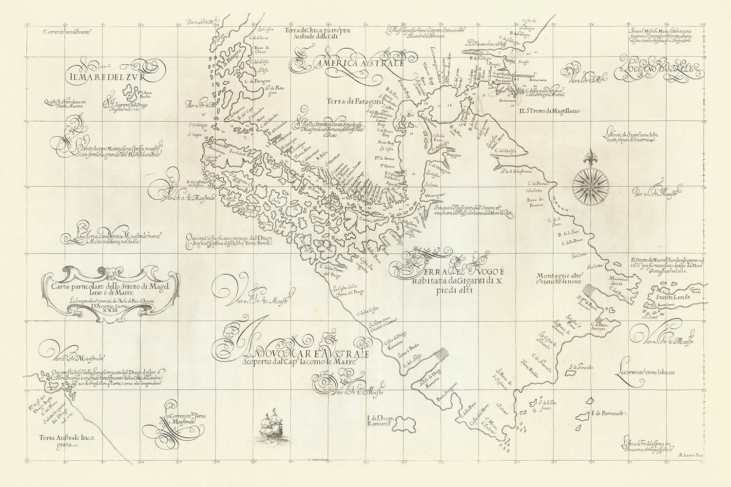
Step into the Age of Discovery with Robert Dudley’s exquisite 1646 nautical chart, the "Carta Particolare dello Stretto di Magellano e di Maire." This remarkable map captures the dramatic waterways at the southern tip of South America, including the legendary Strait of Magellan and the newly discovered Strait of Le Maire. Dudley’s chart is a testament to the era’s relentless quest for maritime knowledge, offering a window into the strategic ambitions and adventurous spirit that defined 17th-century exploration. The map’s main focus is on navigation, charting treacherous passages that were vital to global trade and imperial competition.
What sets this chart apart is its masterful blend of artistry and utility. Dudley’s elegant style is evident in the precise coastal outlines, decorative compass roses, and the careful placement of soundings—numbers indicating water depths in fathoms—along the straits and coasts. Sandbars, water channels, and anchorages are meticulously delineated, providing essential guidance for mariners. These infographics, rare for their time, reflect Dudley’s commitment to accuracy and the practical needs of seafarers, elevating the map from a simple illustration to a sophisticated navigational tool.
Dudley’s chart is also a rich tapestry of the era’s geographical knowledge and speculation. Tierra del Fuego dominates the map as a vast island, surrounded by a constellation of smaller islets, many labeled as unknown—a nod to the mysteries that still shrouded the region. Place names encircle the landmasses, sourced from the pioneering voyages of Dutch explorers Le Maire and Schouten, as well as Spanish expeditions sent in response to Dutch discoveries. These annotations provide a fascinating glimpse into the transfer of knowledge between rival European powers and the evolving understanding of the world’s southernmost frontiers.
Adding to the intrigue, the map preserves the myths and legends that colored early exploration. A note referencing the supposed giants of Patagonia, a story born from Magellan’s first circumnavigation, hints at the blend of fact and folklore that accompanied these perilous journeys. In the lower left, Dudley includes the elusive Southern Continent, or Terra Australis, based on accounts from Sir Francis Drake—whom Dudley knew personally. This speculative landmass underscores the era’s sense of wonder and the persistent belief in undiscovered worlds beyond the known seas.
The historical significance of this map is profound. As one of the earliest and most detailed sea charts of the region, it reflects the intense European interest in controlling access to the Pacific and the competitive spirit of maritime empires. Dudley’s connections to legendary explorers and his innovative cartographic techniques make this chart not only a beautiful work of art but also a vital document of human curiosity and ambition. For collectors and connoisseurs, it offers a rare opportunity to own a piece of the adventurous, enigmatic, and ever-evolving story of global exploration.
Notable places on this map
- The Strait of Magellan (Stretto di Magellano), the main navigational channel between the Atlantic and Pacific Oceans.
- The Strait of Le Maire (Stretto di Maire), a secondary passage east of Tierra del Fuego.
- Tierra del Fuego (Terra del Fuoco), the large island south of the South American mainland.
- Isla de los Estados (Staten Island), located east of Tierra del Fuego.
- Cape Horn (Cabo Hornos), the southernmost headland of the archipelago, though not always distinctly labeled on early maps.
- Various small islets and rocks along the southern coast of Tierra del Fuego, many marked as unknown.
- Noted harbours and anchorages along the straits, labeled for navigational use.
- The southern tip of the South American mainland, north of the straits.
- Speculative landmass of the Southern Continent (Terra Australis), as referenced by Drake.
- Coastal features such as bays, inlets, and promontories, labeled with names from contemporary voyages.
Notable Features & Landmarks
- Detailed coastal outlines and navigational information for the Strait of Magellan and Strait of Le Maire.
- Soundings (water depths in fathoms) marked throughout the straits and coastal areas.
- Compass rose(s) for navigation, indicating directions and possibly magnetic declination.
- Sandbars and water channels outlined, aiding mariners in safe passage.
- Place names encircling Tierra del Fuego, derived from Dutch and Spanish expeditions.
- Notes or legends referencing the myth of giants, a common belief among early European explorers.
- Sailing directions and annotations about the best times to navigate the straits.
- Decorative elements characteristic of Dudley’s elegant cartographic style.
Historical and design context
- Created in 1646 by Robert Dudley, an English explorer, cartographer, and naval engineer known for his influential sea atlas, Arcano del Mare.
- One of the earliest and most detailed sea charts of the region, reflecting up-to-date knowledge and speculation.
- Incorporates data from Dutch and Spanish expeditions (Le Maire, Schouten, Nodales brothers) and English explorers (Drake, Cavendish).
- Focuses on navigation, charting treacherous passages that were vital to global trade and imperial competition.
- Blends artistry and utility, with precise coastal outlines, navigational aids, and decorative compass roses.
- Reflects the intense European interest in controlling access to the Pacific and the competitive spirit of maritime empires.
- Preserves myths and legends of early exploration, such as the supposed giants of Patagonia and the elusive Southern Continent.
- Provides a rare and valuable glimpse into the adventurous, enigmatic, and ever-evolving story of global exploration.
Please double check the images to make sure that a specific town or place is shown on this map. You can also get in touch and ask us to check the map for you.
This map looks great at every size, but I always recommend going for a larger size if you have space. That way you can easily make out all of the details.
This map looks amazing at sizes all the way up to 100in (250cm). If you are looking for a larger map, please get in touch.
The model in the listing images is holding the 24x36in (60x90cm) version of this map.
The fifth listing image shows an example of my map personalisation service.
If you’re looking for something slightly different, check out my collection of the best old maps to see if something else catches your eye.
Please contact me to check if a certain location, landmark or feature is shown on this map.
This would make a wonderful birthday, Christmas, Father's Day, work leaving, anniversary or housewarming gift for someone from the areas covered by this map.
This map is available as a giclée print on acid free archival matte paper, or you can buy it framed. The frame is a nice, simple black frame that suits most aesthetics. Please get in touch if you'd like a different frame colour or material. My frames are glazed with super-clear museum-grade acrylic (perspex/acrylite), which is significantly less reflective than glass, safer, and will always arrive in perfect condition.
This map is also available as a float framed canvas, sometimes known as a shadow gap framed canvas or canvas floater. The map is printed on artist's cotton canvas and then stretched over a handmade box frame. We then "float" the canvas inside a wooden frame, which is available in a range of colours (black, dark brown, oak, antique gold and white). This is a wonderful way to present a map without glazing in front. See some examples of float framed canvas maps and explore the differences between my different finishes.
For something truly unique, this map is also available in "Unique 3D", our trademarked process that dramatically transforms the map so that it has a wonderful sense of depth. We combine the original map with detailed topography and elevation data, so that mountains and the terrain really "pop". For more info and examples of 3D maps, check my Unique 3D page.
Many of our maps and art prints are chosen as thoughtful gifts for homes, offices, studies and meaningful places.
Choose a framed option for the easiest ready-to-hang gift, or choose an unframed print if the recipient may prefer to select their own frame.
We make orders locally in 23 countries around the world, so gifts can often be produced close to the recipient. This helps them arrive faster, travel more safely, and avoid customs or import duty surprises.
- We can deliver directly to the recipient
- Framed pieces arrive ready to hang
- Unframed prints are carefully packed in a strong protective tube
- Almost every order is made locally, for faster, safer gifting
- 90-day returns give the recipient time to decide
If you are not sure what to choose, please contact us. We can help you pick the right map, size, finish or delivery option.
Most orders are made locally and delivered in around 2–3 working days, depending on the product, size and destination.
We print and frame maps and artwork in 23 countries around the world, so your order is usually made close to you or your recipient. That means faster delivery, less time in transit, and no customs or import duty surprises.
Personalised and customised pieces usually take an extra 1–2 working days, because we prepare your design and send it to you for approval before printing.
Very large framed orders can take a little longer, as they need extra care in production and delivery.
Every order is carefully packaged: unframed prints are sent in a strong protective tube, while framed pieces are securely packed with protective materials around the frame.
If you need your order by a particular date, please contact us before ordering. We’ll check the best production route and delivery option for your location.
Express delivery is available at checkout for most countries. Next-day delivery is available in the UK, US, Singapore and the UAE.
Your order is covered by our 90-day returns policy and 10-year guarantee.
Our standard frame is a gallery-style black ash hardwood frame, with a simple, modern look. It is approximately 20mm (0.8in) wide. You can also view some lovely customer photos of framed maps and art.
We use super-clear acrylic glazing, also known as Perspex or Acrylite, instead of traditional glass. It is lighter, safer, and has lower reflectivity, giving the artwork a clearer, cleaner appearance.
Six standard frame colours are available at no extra cost: black, dark brown, dark grey, oak, white, and antique gold. Custom framing and mounting/matting is also available for customers looking for something more specific.
Most maps, art prints, and illustrations are also available as a framed canvas. We use matte cotton canvas, stretch it over a sustainably sourced wooden box frame, and then float the piece within a wooden outer frame. The finished result is beautifully presented, with no glazing between you and the artwork.
All frames are supplied ready to hang, with either string or brackets fitted to the back. Very large frames will include heavy-duty hanging plates and/or a mounting baton. If you have any questions, please get in touch.
We can also supply old maps and artwork on canvas, foam board, cotton rag, and other materials.
If you would prefer to frame your map or artwork yourself, please read our size guide before ordering.
My maps are extremely high quality reproductions of original maps.
I source original, rare maps from libraries, auction houses and private collections around the world, restore them at my London workshop, and then use specialist giclée inks and printers to create beautiful maps that look even better than the original.
My maps are printed on acid-free archival matte (not glossy) paper that feels very high quality and almost like card. In technical terms the paper weight/thickness is 10mil/200gsm. It's perfect for framing.
I print with Epson ultrachrome giclée UV fade resistant pigment inks - some of the best inks you can find.
I can also make maps on canvas, cotton rag and other exotic materials.
Learn more about The Unique Maps Co.
Map personalisation
If you're looking for the perfect anniversary or housewarming gift, I can personalise your map to make it truly unique. For example, I can add a short message, or highlight an important location, or add your family's coat of arms.
The options are almost infinite. Please see my map personalisation page for some wonderful examples of what's possible.
To order a personalised map, select "personalise your map" before adding it to your basket.
Get in touch if you're looking for more complex customisations and personalisations.
Map ageing
I have been asked hundreds of times over the years by customers if they could buy a map that looks even older.
Well, now you can, by selecting Aged before you add a map to your basket.
All the product photos you see on this page show the map in its Original form. This is what the map looks like today.
If you select Aged, I will age your map by hand, using a special and unique process developed through years of studying old maps, talking to researchers to understand the chemistry of aging paper, and of course... lots of practice!
If you're unsure, stick to the Original colour of the map. If you want something a bit darker and older looking, go for Aged.
If you are not happy with your order for any reason, contact me and I'll get it fixed ASAP, free of charge. Please see my returns and refund policy for more information.
I am very confident you will like your restored map or art print. I have been doing this since 1984. I'm a 5-star Etsy seller. I have sold tens of thousands of maps and art prints and have over 5,000 real 5-star reviews. My work has been featured in interior design magazines, on the BBC, and on the walls of dozens of 5-star hotels.
I use a unique process to restore maps and artwork that is massively time consuming and labour intensive. Hunting down the original maps and illustrations can take months. I use state of the art and eye-wateringly expensive technology to scan and restore them. As a result, I guarantee my maps and art prints are a cut above the rest. I stand by my products and will always make sure you're 100% happy with what you receive.
Almost all of my maps and art prints look amazing at large sizes (200cm, 6.5ft+) and I can frame and deliver them to you as well, via special oversized courier. Contact me to discuss your specific needs.
Or try searching for something!


