


Rare Old Street Map of the Pacific Palisades & Huntington Palisades, 1925
20% off 2 — 33% off 3
Add any two eligible items to your bag to receive 20% off. Add a third and it will be complimentary (equivalent to 33% off when purchasing three).
No code needed — the offer applies automatically at checkout.
Valid on all standard maps and fine art prints. You can mix and match any designs.
If you’d like to ship items to multiple addresses, please contact us before placing your order.
Custom and bespoke commissions are excluded.
Contact us if you have any questions
 Designed in London Made in Canada
Designed in London • Made in Canada
Designed in London Made in Canada
Designed in London • Made in Canada

Restored from the original 1925 map and printed to museum-grade archival standards. Read the full description below.
Choose your size
Choose your finish


(More info)
Gift message & custom finish

If you want to add a gift message, or a finish (jigsaw, aluminium board, etc.) that is not available here, please request it in the "order note" when you check out.
Every order is custom made, so if you need the size adjusted slightly, or printed on an unusual material, just let us know. We've done thousands of custom orders over the years, so there's (almost) nothing we can't manage.
You can also contact us before you order, if you prefer!

- Made locally for fast, safe delivery
- No import duty or hidden fees
- Need advice? Message us on WhatsApp
Own a piece of history
7,000+ 5 star reviews


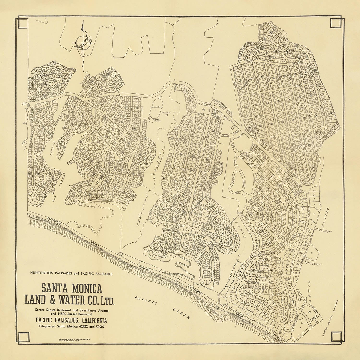
Step into the storied past of Los Angeles’ coastal frontier with the remarkable “Huntington Palisades and Pacific Palisades Santa Monica Land & Water Co. Ltd.” map, created in 1925 at the dawn of a new era for West Los Angeles. This city street map, produced by the visionary Santa Monica Land & Water Company, captures the precise moment when the Pacific Palisades and Huntington Palisades neighborhoods were first being subdivided and offered to the public. It is an extraordinary window into the birth of two of Los Angeles’ most sought-after communities, just as their elegant boulevards and parklands were being carved into the rugged landscape above Will Rogers State Beach.
What sets this map apart as a city map is its meticulous, lot-by-lot depiction of the burgeoning neighborhoods, reflecting the grand ambitions of its developers. The layout reveals a sophisticated design ethos: concentric semi-circular drives, lushly landscaped boulevards, and a central open park area—features inspired by the Olmsted brothers, the famed landscape architects behind New York’s Central Park. Streets such as Alma Real Drive, Pampas Ricas Boulevard, and Chapala Drive were thoughtfully named by engineer W.W. Williams, drawing on his deep connections to Mexico and infusing the community with a sense of romance and adventure.
The map’s historical context is equally captivating. The land’s journey from Abbott Kinney’s forestry station to Collis Huntington’s ambitious seaport dreams, and finally to Robert C. Gillis’ vision of an upper-middle-class enclave, is etched into its very design. The map documents the transformation of this coastal region from rural estates and wild canyons to a planned suburban haven, complete with underground utilities, ornamental lighting, and exclusive beach access. The inclusion of features such as the Chautauqua Assembly Camp’s athletic field, gymnasium, and tennis courts speaks to the area’s early embrace of recreation, education, and community—hallmarks of the Chautauqua movement that once flourished here.
Landmarks and natural features abound, making this map a true collector’s treasure. The dramatic sweep of Temescal Canyon bisects the neighborhoods, while the Pacific Ocean glistens along the map’s edge, anchoring the community to its iconic coastline. The carefully plotted parklands and open spaces, including the central park bounded by El Cerco Place, reflect a commitment to green living that was ahead of its time. The manuscript note marking the location of an early real estate office offers a tangible connection to the excitement and optimism of the 1926 opening ceremonies.
For the discerning collector or connoisseur of Los Angeles history, this map offers more than just a glimpse of streets and lots—it is a testament to the visionaries who shaped the city’s western edge. The Santa Monica Land & Water Company’s rare and unrecorded work captures the spirit of an era when Los Angeles was redefining itself through bold urban planning and community ideals. With its blend of historical significance, elegant design, and evocative detail, this map stands as a singular document of the city’s transformation and enduring allure.
Streets and roads on this map
- Alma Real Drive
- Altata Drive
- Avenida de Cortez
- Avenida de Santa Ynez
- Avenida de las Olas
- Avenida de la Herradura
- Avenida de la Paz
- Avenida de la Riviera
- Bienveneda Avenue
- Chapala Drive
- Chautauqua Boulevard
- Corona del Mar
- El Cerco Place
- Entrada Drive
- Frontera Drive
- Haverford Avenue
- La Cumbre Drive
- Ocampo Drive
- Pampas Ricas Boulevard
- Patencio Lane
- Radcliffe Avenue
- San Remo Drive
- Sunset Boulevard
- Temescal Canyon Road
- Toyopa Drive
- Via de la Paz
- Via de las Olas
- Via Mesa Grande
- Via de la Costa
- West Channel Road
Notable Features & Landmarks
- Athletic Field (labelled)
- Gymnasium (labelled)
- Tennis Courts (labelled)
- Chautauqua Assembly Camp facilities (athletic field, gymnasium, tennis courts)
- Manuscript note indicating the location of an "office" (likely a real estate office)
- Temescal Canyon (geographical feature)
- Will Rogers State Beach (coastal reference point)
- Open park area bounded by El Cerco Place (planned community park)
- Pacific Ocean (coastline shown)
- Subdivision boundaries for Huntington Palisades and Pacific Palisades
Historical and design context
- Created in 1925 by the Santa Monica Land & Water Company, a key developer in West Los Angeles history.
- One of the earliest printed subdivision maps showing the full extent of the Palisades as lots were first marketed for sale in 1926.
- Documents the transformation from rural land and private estates to planned suburban communities.
- Features a sophisticated design with concentric semi-circular drives, landscaped boulevards, and central park areas, influenced by the Olmsted brothers.
- Street names inspired by places and people from Mexico, chosen by project engineer W.W. Williams.
- Reflects the influence of the Chautauqua movement, with facilities for recreation, education, and community.
- Rare and possibly unrecorded, offering a unique glimpse into the early development of Pacific Palisades and Huntington Palisades.
- Provides a lot-by-lot and street-by-street look at the neighborhoods, making it an exceptional city map for collectors and historians.
Please double check the images to make sure that a specific town or place is shown on this map. You can also get in touch and ask us to check the map for you.
This map looks great at every size, but I always recommend going for a larger size if you have space. That way you can easily make out all of the details.
This map looks amazing at sizes all the way up to 50in (125cm). If you are looking for a larger map, please get in touch.
The model in the listing images is holding the 16x16in (40x40cm) version of this map.
The fifth listing image shows an example of my map personalisation service.
If you’re looking for something slightly different, check out my collection of the best old maps to see if something else catches your eye.
Please contact me to check if a certain location, landmark or feature is shown on this map.
This would make a wonderful birthday, Christmas, Father's Day, work leaving, anniversary or housewarming gift for someone from the areas covered by this map.
This map is available as a giclée print on acid free archival matte paper, or you can buy it framed. The frame is a nice, simple black frame that suits most aesthetics. Please get in touch if you'd like a different frame colour or material. My frames are glazed with super-clear museum-grade acrylic (perspex/acrylite), which is significantly less reflective than glass, safer, and will always arrive in perfect condition.
This map is also available as a float framed canvas, sometimes known as a shadow gap framed canvas or canvas floater. The map is printed on artist's cotton canvas and then stretched over a handmade box frame. We then "float" the canvas inside a wooden frame, which is available in a range of colours (black, dark brown, oak, antique gold and white). This is a wonderful way to present a map without glazing in front. See some examples of float framed canvas maps and explore the differences between my different finishes.
For something truly unique, this map is also available in "Unique 3D", our trademarked process that dramatically transforms the map so that it has a wonderful sense of depth. We combine the original map with detailed topography and elevation data, so that mountains and the terrain really "pop". For more info and examples of 3D maps, check my Unique 3D page.
Many of our maps and art prints are chosen as thoughtful gifts for homes, offices, studies and meaningful places.
Choose a framed option for the easiest ready-to-hang gift, or choose an unframed print if the recipient may prefer to select their own frame.
We make orders locally in 23 countries around the world, so gifts can often be produced close to the recipient. This helps them arrive faster, travel more safely, and avoid customs or import duty surprises.
- We can deliver directly to the recipient
- Framed pieces arrive ready to hang
- Unframed prints are carefully packed in a strong protective tube
- Almost every order is made locally, for faster, safer gifting
- 90-day returns give the recipient time to decide
If you are not sure what to choose, please contact us. We can help you pick the right map, size, finish or delivery option.
Most orders are made locally and delivered in around 2–3 working days, depending on the product, size and destination.
We print and frame maps and artwork in 23 countries around the world, so your order is usually made close to you or your recipient. That means faster delivery, less time in transit, and no customs or import duty surprises.
Personalised and customised pieces usually take an extra 1–2 working days, because we prepare your design and send it to you for approval before printing.
Very large framed orders can take a little longer, as they need extra care in production and delivery.
Every order is carefully packaged: unframed prints are sent in a strong protective tube, while framed pieces are securely packed with protective materials around the frame.
If you need your order by a particular date, please contact us before ordering. We’ll check the best production route and delivery option for your location.
Express delivery is available at checkout for most countries. Next-day delivery is available in the UK, US, Singapore and the UAE.
Your order is covered by our 90-day returns policy and 10-year guarantee.
Our standard frame is a gallery-style black ash hardwood frame, with a simple, modern look. It is approximately 20mm (0.8in) wide. You can also view some lovely customer photos of framed maps and art.
We use super-clear acrylic glazing, also known as Perspex or Acrylite, instead of traditional glass. It is lighter, safer, and has lower reflectivity, giving the artwork a clearer, cleaner appearance.
Six standard frame colours are available at no extra cost: black, dark brown, dark grey, oak, white, and antique gold. Custom framing and mounting/matting is also available for customers looking for something more specific.
Most maps, art prints, and illustrations are also available as a framed canvas. We use matte cotton canvas, stretch it over a sustainably sourced wooden box frame, and then float the piece within a wooden outer frame. The finished result is beautifully presented, with no glazing between you and the artwork.
All frames are supplied ready to hang, with either string or brackets fitted to the back. Very large frames will include heavy-duty hanging plates and/or a mounting baton. If you have any questions, please get in touch.
We can also supply old maps and artwork on canvas, foam board, cotton rag, and other materials.
If you would prefer to frame your map or artwork yourself, please read our size guide before ordering.
My maps are extremely high quality reproductions of original maps.
I source original, rare maps from libraries, auction houses and private collections around the world, restore them at my London workshop, and then use specialist giclée inks and printers to create beautiful maps that look even better than the original.
My maps are printed on acid-free archival matte (not glossy) paper that feels very high quality and almost like card. In technical terms the paper weight/thickness is 10mil/200gsm. It's perfect for framing.
I print with Epson ultrachrome giclée UV fade resistant pigment inks - some of the best inks you can find.
I can also make maps on canvas, cotton rag and other exotic materials.
Learn more about The Unique Maps Co.
Map personalisation
If you're looking for the perfect anniversary or housewarming gift, I can personalise your map to make it truly unique. For example, I can add a short message, or highlight an important location, or add your family's coat of arms.
The options are almost infinite. Please see my map personalisation page for some wonderful examples of what's possible.
To order a personalised map, select "personalise your map" before adding it to your basket.
Get in touch if you're looking for more complex customisations and personalisations.
Map ageing
I have been asked hundreds of times over the years by customers if they could buy a map that looks even older.
Well, now you can, by selecting Aged before you add a map to your basket.
All the product photos you see on this page show the map in its Original form. This is what the map looks like today.
If you select Aged, I will age your map by hand, using a special and unique process developed through years of studying old maps, talking to researchers to understand the chemistry of aging paper, and of course... lots of practice!
If you're unsure, stick to the Original colour of the map. If you want something a bit darker and older looking, go for Aged.
If you are not happy with your order for any reason, contact me and I'll get it fixed ASAP, free of charge. Please see my returns and refund policy for more information.
I am very confident you will like your restored map or art print. I have been doing this since 1984. I'm a 5-star Etsy seller. I have sold tens of thousands of maps and art prints and have over 5,000 real 5-star reviews. My work has been featured in interior design magazines, on the BBC, and on the walls of dozens of 5-star hotels.
I use a unique process to restore maps and artwork that is massively time consuming and labour intensive. Hunting down the original maps and illustrations can take months. I use state of the art and eye-wateringly expensive technology to scan and restore them. As a result, I guarantee my maps and art prints are a cut above the rest. I stand by my products and will always make sure you're 100% happy with what you receive.
Almost all of my maps and art prints look amazing at large sizes (200cm, 6.5ft+) and I can frame and deliver them to you as well, via special oversized courier. Contact me to discuss your specific needs.
Or try searching for something!


