


Pictorial Map of Pennsylvania by Ruth Taylor White, 1935: Philadelphia, Pittsburgh, Gettysburg, Amish, Appalachian Mountains
20% off 2 — 33% off 3
Add any two eligible items to your bag to receive 20% off. Add a third and it will be complimentary (equivalent to 33% off when purchasing three).
No code needed — the offer applies automatically at checkout.
Valid on all standard maps and fine art prints. You can mix and match any designs.
If you’d like to ship items to multiple addresses, please contact us before placing your order.
Custom and bespoke commissions are excluded.
Contact us if you have any questions
 Designed in London Made in Canada
Designed in London • Made in Canada
Designed in London Made in Canada
Designed in London • Made in Canada

Choose your size
Choose your finish


(More info)
Gift message & custom finish

If you want to add a gift message, or a finish (jigsaw, aluminium board, etc.) that is not available here, please request it in the "order note" when you check out.
Every order is custom made, so if you need the size adjusted slightly, or printed on an unusual material, just let us know. We've done thousands of custom orders over the years, so there's (almost) nothing we can't manage.
You can also contact us before you order, if you prefer!

- Made locally for fast, safe delivery
- No import duty or hidden fees
- Need advice? Message us on WhatsApp
Own a piece of history
7,000+ 5 star reviews


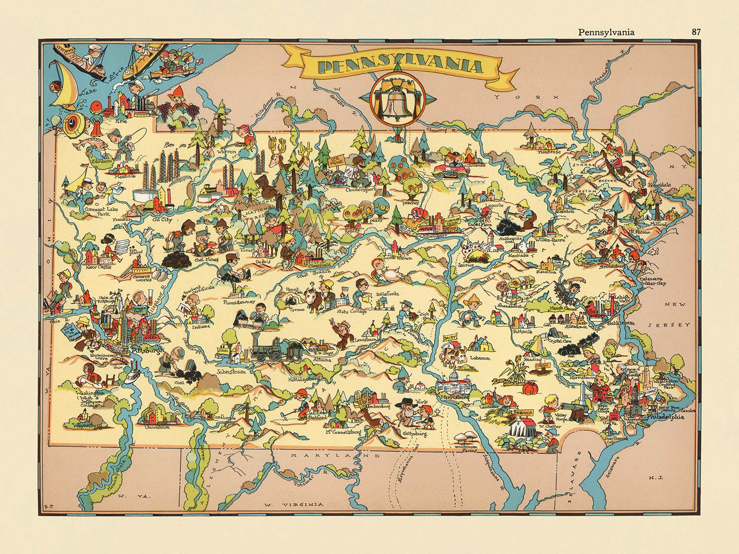
Step into the vibrant world of 1930s Pennsylvania with this captivating pictorial map, originally titled "Pennsylvania." Created in 1935 by the talented Ruth Taylor White, this map is more than a geographic reference—it is a spirited visual celebration of the Keystone State’s character and history. White’s original title hints at her straightforward yet whimsical approach, inviting viewers to explore Pennsylvania through a lens that is both informative and delightfully imaginative. Each corner of the map bursts with color and energy, reflecting the era’s fascination with regional identity and artistic storytelling.
Ruth Taylor White, renowned for her pictorial atlases, brought a unique flair to cartography. Her maps are celebrated for their playful, cartoon-like illustrations that blend artistry with cultural commentary. In this piece, White’s mastery is evident in the way she weaves together Pennsylvania’s counties, infusing each with lively depictions of local life, industry, and tradition. Her work stands as a testament to the power of maps not only to inform but also to enchant and engage, making geography accessible and entertaining for all ages.
The design of this map is a delightful tapestry of Pennsylvania’s diverse landscapes and industries. County boundaries are crisply delineated, while the rolling Appalachian Mountains, the meandering Susquehanna and Delaware Rivers, and the lush northern forests are rendered in stylized, almost storybook fashion. The map is rich with visual cues: from the coal miners of the anthracite region to the steel mills of the west, each illustration offers a window into the state’s economic heart. Railroads, rivers, and agricultural scenes thread the counties together, reflecting the interconnectedness of Pennsylvania’s people and places.
White’s map is also a cultural chronicle, capturing the essence of Pennsylvania’s communities and their historical significance. The Pennsylvania Dutch region comes alive with depictions of Amish farmers and horse-drawn buggies, while the iconic Liberty Bell and Gettysburg battlefield evoke the state’s pivotal role in American history. The presence of dairy farms, logging camps, and bustling railways further highlights the varied livelihoods that shaped the state during the 1930s. This map is not just a record of geography, but a vibrant tableau of everyday life, regional pride, and historical memory.
Prominent cities and towns are thoughtfully placed across the map, from the industrial might of Pittsburgh and Philadelphia to the cultural hubs of Lancaster, Harrisburg, and Erie. Each settlement is nestled within its regional context, surrounded by illustrations that hint at its unique contributions to the state’s story. The map’s playful style belies its depth, offering collectors and history enthusiasts a rare glimpse into Pennsylvania’s past—one where artistry and accuracy walk hand in hand, and every detail invites closer inspection.
Cities and towns on this map
- Philadelphia
- Pittsburgh
- Allentown
- Erie
- Reading
- Scranton
- Bethlehem
- Lancaster
- Harrisburg
- York
- Altoona
- Wilkes-Barre
- State College
- Williamsport
- Easton
Notable Features & Landmarks
- County boundaries are clearly marked and labeled throughout Pennsylvania.
- The Appalachian Mountains are illustrated with stylized mountain imagery across the central part of the state.
- The Susquehanna River is depicted, winding through the state.
- The Delaware River is shown along the eastern border.
- The Allegheny River is illustrated in the western part of the state.
- The Pennsylvania Dutch region is represented with imagery of Amish or Mennonite farmers and horse-drawn buggies.
- Coal mining is depicted in the anthracite region of northeastern Pennsylvania, with miners and mining equipment.
- Steel industry is illustrated in the western part of the state, with smokestacks and steel mills.
- Logging and lumbering activities are shown in the northern forests.
- Dairy farming and agriculture are depicted in various rural areas, with cows, barns, and fields.
- The Liberty Bell is illustrated as a symbol of Pennsylvania's historical significance.
- The Gettysburg battlefield is referenced with imagery of cannons and Civil War soldiers.
- Railroads are shown crisscrossing the state, with trains and tracks illustrated.
- The state’s coat of arms or seal is included in a decorative cartouche.
- The map includes whimsical illustrations of people engaged in local activities, such as hunting, fishing, and sports.
Historical and design context
- Name of the map: Pennsylvania
- Original title: Pennsylvania.
- Mapmaker: Ruth Taylor White
- Date created: 1935
- The map is part of a pictorial or cartoon atlas of the United States, known for its entertaining and whimsical representations of each state.
- The map uses vibrant, colorful illustrations and cartoon-like depictions to represent Pennsylvania's culture, landmarks, and activities as seen in the 1930s.
- The map highlights stereotypical scenes, industries, and cultural elements associated with Pennsylvania, reflecting the state's character during the era.
- The map provides a snapshot of Pennsylvania's society, economy, and culture in the mid-1930s, offering insight into how the state was perceived at the time.
- The map serves both as a geographic reference and as a piece of social commentary, using humor and caricature to engage viewers.
- The pictorial style was popular in the early 20th century for engaging audiences and making geography accessible and entertaining.
Please double check the images to make sure that a specific town or place is shown on this map. You can also get in touch and ask us to check the map for you.
This map looks great at every size, but I always recommend going for a larger size if you have space. That way you can easily make out all of the details.
This map looks amazing at sizes all the way up to 50in (125cm). If you are looking for a larger map, please get in touch.
The model in the listing images is holding the 18x24in (45x60cm) version of this map.
The fifth listing image shows an example of my map personalisation service.
If you’re looking for something slightly different, check out my collection of the best old maps to see if something else catches your eye.
Please contact me to check if a certain location, landmark or feature is shown on this map.
This would make a wonderful birthday, Christmas, Father's Day, work leaving, anniversary or housewarming gift for someone from the areas covered by this map.
This map is available as a giclée print on acid free archival matte paper, or you can buy it framed. The frame is a nice, simple black frame that suits most aesthetics. Please get in touch if you'd like a different frame colour or material. My frames are glazed with super-clear museum-grade acrylic (perspex/acrylite), which is significantly less reflective than glass, safer, and will always arrive in perfect condition.
This map is also available as a float framed canvas, sometimes known as a shadow gap framed canvas or canvas floater. The map is printed on artist's cotton canvas and then stretched over a handmade box frame. We then "float" the canvas inside a wooden frame, which is available in a range of colours (black, dark brown, oak, antique gold and white). This is a wonderful way to present a map without glazing in front. See some examples of float framed canvas maps and explore the differences between my different finishes.
For something truly unique, this map is also available in "Unique 3D", our trademarked process that dramatically transforms the map so that it has a wonderful sense of depth. We combine the original map with detailed topography and elevation data, so that mountains and the terrain really "pop". For more info and examples of 3D maps, check my Unique 3D page.
Many of our maps and art prints are chosen as thoughtful gifts for homes, offices, studies and meaningful places.
Choose a framed option for the easiest ready-to-hang gift, or choose an unframed print if the recipient may prefer to select their own frame.
We make orders locally in 23 countries around the world, so gifts can often be produced close to the recipient. This helps them arrive faster, travel more safely, and avoid customs or import duty surprises.
- We can deliver directly to the recipient
- Framed pieces arrive ready to hang
- Unframed prints are carefully packed in a strong protective tube
- Almost every order is made locally, for faster, safer gifting
- 90-day returns give the recipient time to decide
If you are not sure what to choose, please contact us. We can help you pick the right map, size, finish or delivery option.
Most orders are made locally and delivered in around 2–3 working days, depending on the product, size and destination.
We print and frame maps and artwork in 23 countries around the world, so your order is usually made close to you or your recipient. That means faster delivery, less time in transit, and no customs or import duty surprises.
Personalised and customised pieces usually take an extra 1–2 working days, because we prepare your design and send it to you for approval before printing.
Very large framed orders can take a little longer, as they need extra care in production and delivery.
Every order is carefully packaged: unframed prints are sent in a strong protective tube, while framed pieces are securely packed with protective materials around the frame.
If you need your order by a particular date, please contact us before ordering. We’ll check the best production route and delivery option for your location.
Express delivery is available at checkout for most countries. Next-day delivery is available in the UK, US, Singapore and the UAE.
Your order is covered by our 90-day returns policy and 10-year guarantee.
Our standard frame is a gallery-style black ash hardwood frame, with a simple, modern look. It is approximately 20mm (0.8in) wide. You can also view some lovely customer photos of framed maps and art.
We use super-clear acrylic glazing, also known as Perspex or Acrylite, instead of traditional glass. It is lighter, safer, and has lower reflectivity, giving the artwork a clearer, cleaner appearance.
Six standard frame colours are available at no extra cost: black, dark brown, dark grey, oak, white, and antique gold. Custom framing and mounting/matting is also available for customers looking for something more specific.
Most maps, art prints, and illustrations are also available as a framed canvas. We use matte cotton canvas, stretch it over a sustainably sourced wooden box frame, and then float the piece within a wooden outer frame. The finished result is beautifully presented, with no glazing between you and the artwork.
All frames are supplied ready to hang, with either string or brackets fitted to the back. Very large frames will include heavy-duty hanging plates and/or a mounting baton. If you have any questions, please get in touch.
We can also supply old maps and artwork on canvas, foam board, cotton rag, and other materials.
If you would prefer to frame your map or artwork yourself, please read our size guide before ordering.
My maps are extremely high quality reproductions of original maps.
I source original, rare maps from libraries, auction houses and private collections around the world, restore them at my London workshop, and then use specialist giclée inks and printers to create beautiful maps that look even better than the original.
My maps are printed on acid-free archival matte (not glossy) paper that feels very high quality and almost like card. In technical terms the paper weight/thickness is 10mil/200gsm. It's perfect for framing.
I print with Epson ultrachrome giclée UV fade resistant pigment inks - some of the best inks you can find.
I can also make maps on canvas, cotton rag and other exotic materials.
Learn more about The Unique Maps Co.
Map personalisation
If you're looking for the perfect anniversary or housewarming gift, I can personalise your map to make it truly unique. For example, I can add a short message, or highlight an important location, or add your family's coat of arms.
The options are almost infinite. Please see my map personalisation page for some wonderful examples of what's possible.
To order a personalised map, select "personalise your map" before adding it to your basket.
Get in touch if you're looking for more complex customisations and personalisations.
Map ageing
I have been asked hundreds of times over the years by customers if they could buy a map that looks even older.
Well, now you can, by selecting Aged before you add a map to your basket.
All the product photos you see on this page show the map in its Original form. This is what the map looks like today.
If you select Aged, I will age your map by hand, using a special and unique process developed through years of studying old maps, talking to researchers to understand the chemistry of aging paper, and of course... lots of practice!
If you're unsure, stick to the Original colour of the map. If you want something a bit darker and older looking, go for Aged.
If you are not happy with your order for any reason, contact me and I'll get it fixed ASAP, free of charge. Please see my returns and refund policy for more information.
I am very confident you will like your restored map or art print. I have been doing this since 1984. I'm a 5-star Etsy seller. I have sold tens of thousands of maps and art prints and have over 5,000 real 5-star reviews. My work has been featured in interior design magazines, on the BBC, and on the walls of dozens of 5-star hotels.
I use a unique process to restore maps and artwork that is massively time consuming and labour intensive. Hunting down the original maps and illustrations can take months. I use state of the art and eye-wateringly expensive technology to scan and restore them. As a result, I guarantee my maps and art prints are a cut above the rest. I stand by my products and will always make sure you're 100% happy with what you receive.
Almost all of my maps and art prints look amazing at large sizes (200cm, 6.5ft+) and I can frame and deliver them to you as well, via special oversized courier. Contact me to discuss your specific needs.
Or try searching for something!


