


Antigua Mapa de Ucrania "Tierra de los Cosacos", 1943: Kyiv, Mar Negro, Cárpatos

-
![]() Handmade in Canada
Handmade in Canada
-
Free delivery &
usually dispatched next day
Dispatched next working day
Your map should be dispatched the next working day.
Express delivery is available at checkout.
If you need your order to arrive by a certain date, contact me and we can discuss your options.
Please note that personalised maps, and some larger framed maps can take longer to produce and deliver.
-
90 day money back guarantee
ⓘ
90 días para devolver y reembolsar
Los productos se pueden devolver dentro de los 90 días para un reembolso completo, o cambio por otro producto.
Para artículos personalizados o hechos a medida, podemos ofrecerte un crédito en la tienda o una tarjeta de regalo que no caduca, ya que no podemos revender pedidos personalizados.
Si tienes alguna pregunta, ponte en contacto. Para más información, consulta nuestra política de devoluciones y cambios.

My maps are rare, museum-grade, restored old maps sourced from libraries, auction houses and private collections across the globe.
Framing & free personalisation available
1. Select your size
2. Frame & personalise your map
Make your map unique with framing, hand-drawn customisation, vintage ageing, pop art text, unique 3D styling and moreMensaje de regalo y acabado personalizado

Si deseas agregar un mensaje de regalo, o un acabado (rompecabezas, tablero de aluminio, etc.) que no esté disponible aquí, por favor solicítalo en la "nota del pedido" cuando realices la compra.
Cada pedido es hecho a medida, así que si necesitas que el tamaño se ajuste ligeramente, o que se imprima en un material inusual, háznoslo saber. Hemos realizado miles de pedidos personalizados a lo largo de los años, así que hay (casi) nada que no podamos gestionar.
También puedes contactarnos antes de hacer tu pedido, ¡si lo prefieres!

- Handmade locally. No import duty or tax
- FREE Delivery. Arrives in 2-3 days
- Love it or your money back
- Questions? WhatsApp me any time
Own a piece of history
5,000+ 5 star reviews


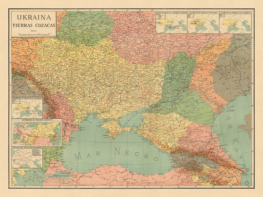
El mapa titulado "Ukraina, Tierras Cossacas," elaborado por B. Mylinsky en 1943, ofrece una fascinante visión de un momento crucial en la historia. Creado durante los tumultuosos años de la Segunda Guerra Mundial, este mapa fue producido por nacionalistas ucranianos que residían en Argentina, un centro para la diáspora ucraniana. Refleja una visión de Ucrania con fronteras ampliadas, capturando territorios que fueron históricamente significativos para la comunidad. Este mapa no solo sirve como una guía geográfica, sino también como un testimonio de las aspiraciones culturales y políticas de los ucranianos durante un tiempo de agitación global.
El mapa es un vibrante tapiz de divisiones políticas, ciudades principales y características naturales, meticulosamente detallado para reflejar el paisaje geopolítico de la época. Incluye partes de Polonia, Bielorrusia, Rusia, Moldavia y Transnistria, regiones que históricamente estaban entrelazadas con Ucrania. Esta vista ampliada resalta la compleja historia y los lazos culturales que han dado forma a Europa del Este. La inclusión de repúblicas cosacas en el sur de Rusia añade otra capa de intriga histórica, haciendo referencia a territorios que reclamaron autonomía durante la Guerra Civil Rusa.
Ciudades como Kyiv, Kharkiv y Odesa están destacadas, sirviendo como centros culturales y económicos clave. La representación detallada de estas ciudades, junto con otras como Lviv y Dnipro, proporciona una visión del paisaje urbano de la época. La inclusión de pueblos de países vecinos, como Przemyśl y Chelm en Polonia, y Gomel en Bielorrusia, enfatiza aún más la interconexión de la región. Cada ciudad y pueblo es un marcador de importancia histórica, contribuyendo al rico tapiz de la historia de Europa del Este.
Las características naturales están elegantemente retratadas, con el Mar Negro y el Mar de Azov proporcionando un impresionante telón de fondo para las regiones del sur. La sombra de relieve resalta los terrenos montañosos de los Cárpatos y el Cáucaso, añadiendo profundidad y dimensión al mapa. Estas características geográficas no solo definen el paisaje físico, sino que también juegan un papel crucial en las narrativas históricas de la región. La atención del mapa a los recursos naturales, como los depósitos de combustible y minerales, subraya la importancia económica de estas áreas.
El mapa de B. Mylinsky es más que un logro cartográfico; es una ventana al pasado, reflejando las esperanzas y sueños de una nación durante un tiempo de conflicto. Captura la esencia de una tierra rica en historia, cultura y belleza natural. Este mapa es un tesoro para coleccionistas, ofreciendo una perspectiva única sobre Ucrania y sus vecinos, y sirviendo como un recordatorio conmovedor del espíritu perdurable de su gente.
Ciudades y pueblos en este mapa
- Ucrania:
- Kyiv
- Kharkiv
- Odesa
- Dnipro
- Lviv
- Zaporizhzhia
- Kryvyi Rih
- Mykolaiv
- Mariupol
-
Vinnytsia
-
Polonia (contexto histórico):
- Przemyśl
-
Chelm
-
Bielorrusia (contexto histórico):
-
Gomel
-
Rusia (contexto histórico):
- Belgorod
-
Starodub
-
Moldavia:
-
Chișinău
-
Transnistria:
- Tiraspol
Características y monumentos notables
- Mapas insets:
- Depósitos de combustible natural
- Distribución de la población ucraniana en Europa del Este
- Zonas horarias
-
Depósitos minerales
-
Cuerpos de agua:
- Mar Negro
-
Mar de Azov
-
Montañas: Alivio mostrado en áreas como los Cárpatos y el Cáucaso.
-
Fronteras: Fronteras ampliadas de Ucrania que incluyen regiones de países vecinos.
Contexto histórico y de diseño
- Cartógrafo/Editor: B. Mylinsky
- Fecha de creación: 1943
- Contexto histórico: Creado durante la Segunda Guerra Mundial por nacionalistas ucranianos en Argentina.
- Contexto político: Muestra a Ucrania con fronteras ampliadas, justificadas históricamente por la comunidad.
- Repúblicas cosacas: Marca regiones en el sur de Rusia como diferentes repúblicas cosacas, reflejando territorios que reclamaron existencia durante la Guerra Civil Rusa (1918-1922).
- Diseño/Estilo: Mapa a color con relieve mostrado por sombreado, incluye divisiones políticas detalladas y recursos naturales.
Por favor, verifica las imágenes para asegurarte de que una ciudad o lugar específico esté mostrado en este mapa. También puedes ponerte en contacto y pedirnos que revisemos el mapa por ti.
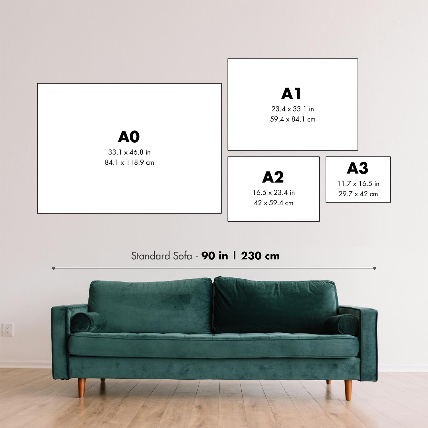
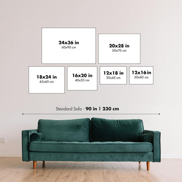
Este mapa se ve genial en cualquier tamaño, pero siempre recomiendo optar por un tamaño más grande si tienes espacio. De esa manera, puedes distinguir fácilmente todos los detalles.
Este mapa se ve increíble en tamaños de hasta 100in (250cm). Si estás buscando un mapa más grande, por favor ponte en contacto.
Por favor, ten en cuenta: las etiquetas en este mapa son difíciles de leer si pides un mapa que mide 20in (50cm) o menos. El mapa sigue siendo muy atractivo, pero si deseas leer el mapa fácilmente, por favor compra un tamaño más grande.
El modelo en las imágenes de la lista sostiene la versión de este mapa de 18x24in (45x60cm).
La quinta imagen de la lista muestra un ejemplo de mi servicio de personalización de mapas.
Si estás buscando algo ligeramente diferente, echa un vistazo a mi colección de los mejores mapas antiguos para ver si algo más llama tu atención.
Por favor contáctame para verificar si una ubicación, hito o característica específica está mostrada en este mapa.
Este sería un maravilloso regalo de cumpleaños, Navidad, Día del Padre, despedida laboral, aniversario o inauguración de casa para alguien de las áreas cubiertas por este mapa.
Este mapa está disponible como una impresión giclée en papel mate libre de ácido y de archivo, o puedes comprarlo enmarcado. El marco es un marco negro simple y bonito que se adapta a la mayoría de las estéticas. Por favor, ponte en contacto si deseas un color o material de marco diferente. Mis marcos están envidriados con acrílico de grado museo superclaro (perspex/acrylite), que es significativamente menos reflectante que el vidrio, más seguro, y siempre llegará en perfectas condiciones.
This map is also available as a float framed canvas, sometimes known as a shadow gap framed canvas or canvas floater. The map is printed on artist's cotton canvas and then stretched over a handmade box frame. We then "float" the canvas inside a wooden frame, which is available in a range of colours (black, dark brown, oak, antique gold and white). This is a wonderful way to present a map without glazing in front. See some examples of float framed canvas maps and explore the differences between my different finishes.
For something truly unique, this map is also available in "Unique 3D", our trademarked process that dramatically transforms the map so that it has a wonderful sense of depth. We combine the original map with detailed topography and elevation data, so that mountains and the terrain really "pop". For more info and examples of 3D maps, check my Unique 3D page.
Para la mayoría de los pedidos, el tiempo de entrega es de aproximadamente 3 días laborables. Los productos personalizados y a medida tardan más, ya que tengo que hacer la personalización y enviártelo para su aprobación, lo cual suele tardar 1 o 2 días.
Tenga en cuenta que los pedidos enmarcados muy grandes suelen tardar más en fabricarse y entregarse.
Si necesitas que tu pedido llegue para una fecha determinada, por favor contáctame antes de hacer el pedido para que podamos encontrar la mejor manera de asegurarnos de que recibas tu pedido a tiempo.
Imprimo y enmarco mapas y obras de arte en 23 países alrededor del mundo. Esto significa que tu pedido se fabricará localmente, lo que reduce el tiempo de entrega y asegura que no se dañe durante el envío. Nunca pagarás aranceles de aduana o impuestos de importación, y pondremos menos CO2 en el aire.
Todos mis mapas y impresiones artísticas están bien empaquetados y enviados en un tubo resistente si no están enmarcados, o rodeados de espuma si están enmarcados.
Intento enviar todos los pedidos dentro de 1 o 2 días después de recibir tu pedido, aunque algunos productos (como mascarillas, tazas y bolsas de tela) pueden tardar más en fabricarse.
Si seleccionas Entrega Exprés al finalizar la compra, priorizaremos tu pedido y lo enviaremos por mensajería de 1 día (Fedex, DHL, UPS, Parcelforce).
La entrega al día siguiente también está disponible en algunos países (EE. UU., Reino Unido, Singapur, EAU), pero por favor intenta hacer tu pedido temprano en el día para que podamos enviarlo a tiempo.
Mi marco estándar es un marco de madera de fresno negro estilo galería. Es simple y tiene un aspecto bastante moderno. Mi marco estándar tiene alrededor de 20 mm (0.8 in) de ancho.
Utilizo acrílico super claro (perspex/acrylite) para el vidrio del marco. Es más ligero y seguro que el vidrio, y se ve mejor, ya que la reflectividad es menor.
Seis colores de marco estándar están disponibles de forma gratuita (negro, marrón oscuro, gris oscuro, roble, blanco y oro antiguo).El enmarcado y montaje/matizado personalizado está disponible si buscas algo diferente.
La mayoría de los mapas, arte e ilustraciones también están disponibles como un lienzo enmarcado. Utilizamos lienzo de algodón mate (no brillante), lo estiramos sobre un marco de madera de caja de origen sostenible, y luego 'flotamos' la pieza dentro de un marco de madera. El resultado final es bastante hermoso, y no hay cristal que se interponga.
Todos los marcos se proporcionan "listos para colgar", con una cuerda o soportes en la parte posterior. Los marcos muy grandes tendrán placas de colgar de alta resistencia y/o un listón de montaje. Si tienes alguna pregunta, por favor ponte en contacto.
Mira algunos ejemplos de mis mapas enmarcados y mapas en lienzo enmarcados.
Alternativamente, también puedo proporcionar mapas antiguos y obras de arte en lienzo, tablero de espuma, papel de algodón y otros materiales.
Si deseas enmarcar tu mapa o obra de arte tú mismo, por favor lee mi guía de tamaños primero.
Algunos de mis mapas antiguos ahora están disponibles como lienzos enmarcados. Por favor contáctame si deseas pedir un tamaño que no está disponible en mi tienda.
Los mapas antiguos en lienzo son una alternativa interesante a los mapas enmarcados convencionalmente. Dependiendo de tu gusto personal y la decoración de la habitación, los mapas en lienzo pueden "destacar" un poco más que un mapa enmarcado.
Mis mapas son reproducciones de mapas originales de altísima calidad.
Obtengo mapas originales y raros de bibliotecas, casas de subastas y colecciones privadas de todo el mundo, los restauro en mi taller de Londres y luego uso tintas e impresoras giclée especializadas para crear hermosos mapas que lucen incluso mejor que el original.
Mis mapas están impresos en papel de archivo mate (no brillante) sin ácido que se siente de muy alta calidad y casi como una tarjeta. En términos técnicos, el peso/grosor del papel es de 10 mil/200 g/m². Es perfecto para enmarcar.
Imprimo con tintas pigmentadas Epson ultrachrome giclée UV resistentes a la decoloración, algunas de las mejores tintas que puedes encontrar.
yo también puedo hacer mapas sobre lienzo, trapo de algodón y otros materiales exóticos.
Obtenga más información sobre The Unique Maps Co..
Personalización de mapas
Si está buscando el regalo perfecto de aniversario o inauguración de la casa, puedo personalizar su mapa para hacerlo verdaderamente único. Por ejemplo, puedo agregar un mensaje corto, resaltar una ubicación importante o agregar el escudo de armas de su familia.
Las opciones son casi infinitas. Por favor mira mi página de personalización de mapas para ver algunos maravillosos ejemplos de lo que es posible.
Para pedir un mapa personalizado, seleccione "personalizar su mapa" antes de agregarlo a su carrito.
Ponerse en contacto si buscas personalizaciones y personalizaciones más complejas.
Envejecimiento del mapa
A lo largo de los años, los clientes me han preguntado cientos de veces si podían comprar un mapa que se viera uniforme. más viejo.
Bueno, ahora puedes hacerlo seleccionando Envejecido antes de agregar un mapa a tu carrito.
Todas las fotografías de productos que ve en esta página muestran el mapa en su forma original. Así es como se ve el mapa hoy.
Si selecciona Envejecido, envejeceré su mapa a mano, usando un proceso especial y único desarrollado a través de años de estudiar mapas antiguos, hablar con investigadores para comprender la química del envejecimiento del papel y, por supuesto... ¡mucha práctica!
Si no estás seguro, quédate con el color original del mapa. Si quieres algo un poco más oscuro y más viejo buscando, opte por Envejecido.
Si no estás satisfecho con tu pedido por cualquier motivo, contáctame para un reembolso sin complicaciones. Por favor, consulta nuestra política de devoluciones y reembolsos para más información.
Estoy muy seguro de que te gustará tu mapa o impresión artística restaurada. He estado haciendo esto desde 1984. Soy un vendedor de 5 estrellas en Etsy. He vendido decenas de miles de mapas e impresiones artísticas y tengo más de 5,000 opiniones reales de 5 estrellas.
Utilizo un proceso único para restaurar mapas y obras de arte que consume mucho tiempo y mano de obra. Buscar los mapas e ilustraciones originales puede llevar meses. Utilizo tecnología de última generación y extremadamente cara para escanear y restaurarlos. Como resultado, garantizo que mis mapas e impresiones artísticas son superiores a los demás - por eso puedo ofrecer un reembolso sin complicaciones.
Casi todos mis mapas e impresiones artísticas se ven increíbles en tamaños grandes (200cm, 6.5ft+) y también puedo enmarcarlos y entregártelos a través de un servicio de mensajería especial para tamaños grandes. Contáctame para discutir tus necesidades específicas.
Or try searching for something!


