


Old Map of US Tornado Activity 1930-1974 by Fujita & Pearson: Paths, Death Statistics, Tornado Alley
Compra 2, Llévate 1 Gratis
Si añades 2 artículos a tu carrito, puedes añadir un tercer producto gratis.
Esto aplica a todos los mapas y obras de arte, incluyendo piezas personalizadas y personalizadas. Puedes pedir 3 de lo mismo, o 3 cosas diferentes.
Esto equivale a un descuento del 33%, que será el mayor descuento disponible en mi tienda este año.
¡Aprovecha la oferta y cubre tus paredes con hermosos mapas y arte!
Contáctame si tienes alguna pregunta.

-
![]() Handmade in Canada
Handmade in Canada
-
Free delivery &
usually dispatched next day
Dispatched next working day
Your map should be dispatched the next working day.
Deliveries over the Christmas and New Year period may be slightly delayed, as couriers and postal services catch up with a huge backlog of packages.
Express delivery is available at checkout.
If you need your order to arrive by a certain date, contact me and we can discuss your options.
Please note that personalised maps, and some larger framed maps can take longer to produce and deliver.
-
FREE gift preview
ⓘ
Digital gift preview
After you complete your order, you can send a beautiful digital preview to the gift recipient. Just provide their email address and we'll do the rest. (Their email address will not be stored or used for any other purpose.)
This is perfect if you're concerned that your order might not arrive in time.
You can also buy a real non-expiring gift card, and email it directly to the recipient, so they can buy their own map or artwork.
-
90 day money back guarantee
ⓘ
90 días para devolver y reembolsar
Los productos se pueden devolver dentro de los 90 días para un reembolso completo, o cambio por otro producto.
Para artículos personalizados y hechos a medida, podemos ofrecerte crédito en la tienda o una tarjeta de regalo sin fecha de caducidad, ya que no podemos revender pedidos personalizados.
Si tienes alguna pregunta, ponte en contacto. Para más información, consulta nuestra política de devoluciones y cambios.

My maps are rare, museum-grade, restored old maps sourced from libraries, auction houses and private collections across the globe.
Framing & free personalisation available
1. Select your size
Click here to order a custom size.
2. Frame & personalise your map
Make your map unique with framing, hand-drawn customisation, vintage ageing, pop art text, unique 3D styling and more.


Mensaje de regalo y acabado personalizado

Si deseas agregar un mensaje de regalo, o un acabado (rompecabezas, tablero de aluminio, etc.) que no esté disponible aquí, por favor solicítalo en la "nota del pedido" cuando realices la compra.
Cada pedido es hecho a medida, así que si necesitas que el tamaño se ajuste ligeramente, o que se imprima en un material inusual, háznoslo saber. Hemos realizado miles de pedidos personalizados a lo largo de los años, así que hay (casi) nada que no podamos gestionar.
También puedes contactarnos antes de hacer tu pedido, ¡si lo prefieres!

- Handmade locally. No import duty or tax
- FREE worldwide delivery
- Love it or your money back (90 days)
- Questions? WhatsApp me any time
Own a piece of history
5,000+ 5 star reviews


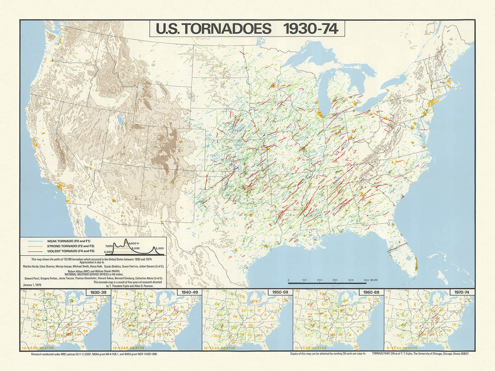
This remarkable thematic map, titled "U.S. tornadoes, 1930-74," offers a visually arresting chronicle of nearly half a century of tornado activity across the contiguous United States. Created in 1974 by the eminent meteorologists T. Theodore Fujita and Allen D. Pearson, the map presents the paths of 19,189 tornadoes, weaving a dense and intricate tapestry of meteorological history. The main focus is the frequency, distribution, and human impact of tornadoes, making this map not only a cartographic achievement but also a profound statement on the intersection of natural forces and human lives.
At the heart of this map lies a masterful use of infographic techniques. Each tornado path is meticulously traced, resulting in a dramatic concentration of lines that immediately draws the eye to the infamous "Tornado Alley" of the central United States. The map’s design elegantly balances clarity and density, using subtle background features such as state boundaries, major rivers, and the Great Lakes to provide orientation without distracting from the central data. This approach reflects the best traditions of 1970s scientific cartography, where function and form are harmoniously intertwined.
What truly elevates this map is its integration of statistical insets, which chart tornado-related fatalities by decade from 1930 through 1974. These five inset maps provide a sobering counterpoint to the swirling tornado paths, contextualizing the human cost of these natural disasters. The inclusion of these infographics transforms the map from a mere record of meteorological events into a nuanced exploration of risk, resilience, and the evolution of public safety in the face of nature’s unpredictability.
The map’s creators, T. Theodore Fujita and Allen D. Pearson, are legendary figures in the field of severe weather research. Fujita, in particular, is renowned for developing the Fujita scale, which remains a foundational tool for assessing tornado intensity. Their collaboration on this map not only lends it scientific authority but also marks a pivotal moment in the history of meteorology, as researchers began to harness visual data to communicate complex patterns and drive public understanding.
Beyond its immediate scientific value, this map stands as a cultural and historical artifact. It captures a period of transformation in American meteorology, when advances in data collection and analysis began to yield new insights into the patterns of extreme weather. For collectors, historians, and weather enthusiasts alike, this map offers both a snapshot of a defining era and a testament to the enduring power of cartography to illuminate the forces that shape our world.
Places on this map
- United States of America (contiguous 48 states)
- Texas
- Oklahoma
- Kansas
- Nebraska
- Iowa
- Missouri
- Arkansas
- Illinois
- Indiana
- Ohio
- Mississippi River
- Great Lakes (Lake Superior, Lake Michigan, Lake Huron, Lake Erie, Lake Ontario)
- Appalachian Mountains
- Southeastern states (e.g., Alabama, Mississippi, Georgia, Tennessee)
- Central Plains region (Tornado Alley)
- Western United States (less tornado activity)
- Northeastern United States (less tornado activity)
- State boundaries (all contiguous U.S. states)
- U.S. regional divisions (Midwest, South, Plains, Southeast)
- Borders with Canada and Mexico
- Gulf of Mexico (southern boundary)
- Atlantic Ocean (eastern boundary)
- Pacific Ocean (western boundary, though not the focus)
- Inset maps showing the entire U.S. for death statistics by decade
Notable Features & Landmarks
- Dense clusters of tornado paths, especially in the central United States (Tornado Alley)
- Clearly marked tornado paths, each representing an individual tornado event
- Five inset maps, each depicting tornado-related deaths by decade (1930-39, 1940-49, 1950-59, 1960-69, 1970-74)
- Major rivers, such as the Mississippi River, are depicted to aid geographic orientation
- The Great Lakes are shown as major water bodies
- The Appalachian Mountains are visible, acting as a geographic reference
- The map legend explains the symbols and lines used for tornado paths and death statistics
- The map title and credits to T. Theodore Fujita and Allen D. Pearson are prominently displayed
- The highest density of tornado paths appears in states like Texas, Oklahoma, Kansas, Nebraska, and Iowa
- Lower density of tornado paths in the western and northeastern United States
- The southeastern U.S. also shows a notable number of tornado paths
- The inset maps use shading or dots to show the number of tornado-related deaths per state or region
- The map uses contrasting colors or line weights to distinguish tornado paths from other features
- The overall design is data-dense, emphasizing the frequency and distribution of tornadoes
- The map includes a scale bar for reference
- Tornado paths sometimes cross state lines, illustrating the wide-ranging nature of some tornadoes
- The map is oriented with north at the top, following standard cartographic conventions
Historical and design context
- Name of the map: U.S. tornadoes, 1930-74
- Created by T. Theodore Fujita and Allen D. Pearson in 1974
- Thematic infographic map, focusing on tornado occurrences in the United States
- Visualizes the paths of 19,189 tornadoes that occurred in the U.S. between 1930 and 1974
- Includes insets showing tornado-related deaths for five different decades: 1930-39, 1940-49, 1950-59, 1960-69, and 1970-74
- Scale of the map is approximately 1:6,000,000
- Mapmakers: T. Theodore Fujita, a pioneering meteorologist known for developing the Fujita scale (F-scale) for tornado intensity, and Allen D. Pearson, a notable figure in severe weather research
- Published in 1974, shortly after the devastating 1974 Super Outbreak, one of the largest tornado outbreaks in U.S. history
- The map is a product of a period when tornado documentation and research were becoming more systematic, with increased use of meteorological data
- Provides a unique visual summary of over four decades of tornado activity, emphasizing the frequency and distribution of tornado paths
- Thematically, the map addresses natural hazards, specifically tornadoes, and their impact on human life
- The inset maps give valuable historical context on the changing patterns of tornado-related fatalities over time
- The map likely served as a research tool and public awareness resource during a time of increasing interest in disaster preparedness
- The design uses dense, overlapping lines to represent tornado paths, visually conveying the concentration of tornado activity in certain regions
- Highlights the "Tornado Alley" region in the central U.S., known for its high frequency of tornadoes
- Reflects the state of meteorological science and data collection in the mid-20th century
- The map's creation reflects a growing collaboration between meteorologists and cartographers for public communication
- Historical significance: represents one of the earliest comprehensive visualizations of tornado data in the U.S.
- The data period (1930-1974) includes significant technological and methodological advances in weather observation
- The map provides a baseline for comparing tornado activity before and after the implementation of modern warning systems
- It serves as a historical document, showing the evolution of both tornado research and public safety efforts
- The map would have contributed to public understanding of tornado risks and influenced policy and building codes in tornado-prone areas
- The map's style is characteristic of 1970s infographics, with a focus on clarity and dense data visualization
- The inclusion of death statistics contextualizes the human cost of tornadoes, not just their frequency
- The map is an early example of thematic mapping in meteorology, preceding the widespread adoption of GIS
- The map's publication by leading tornado researchers gives it additional scientific credibility
- The infographic approach makes complex meteorological data accessible to a wider audience
- The map's focus on the U.S. reflects the country's unique vulnerability to tornadoes due to geography and climate
- The map does not include Alaska, Hawaii, or U.S. territories, focusing solely on the contiguous states
Please double check the images to make sure that a specific town or place is shown on this map. You can also get in touch and ask us to check the map for you.
This map looks great at every size, but I always recommend going for a larger size if you have space. That way you can easily make out all of the details.
This map looks amazing at sizes all the way up to 90in (230cm). If you are looking for a larger map, please get in touch.
The model in the listing images is holding the 18x24in (45x60cm) version of this map.
The fifth listing image shows an example of my map personalisation service.
If you’re looking for something slightly different, check out my collection of the best old maps to see if something else catches your eye.
Please contact me to check if a certain location, landmark or feature is shown on this map.
This would make a wonderful birthday, Christmas, Father's Day, work leaving, anniversary or housewarming gift for someone from the areas covered by this map.
This map is available as a giclée print on acid free archival matte paper, or you can buy it framed. The frame is a nice, simple black frame that suits most aesthetics. Please get in touch if you'd like a different frame colour or material. My frames are glazed with super-clear museum-grade acrylic (perspex/acrylite), which is significantly less reflective than glass, safer, and will always arrive in perfect condition.
This map is also available as a float framed canvas, sometimes known as a shadow gap framed canvas or canvas floater. The map is printed on artist's cotton canvas and then stretched over a handmade box frame. We then "float" the canvas inside a wooden frame, which is available in a range of colours (black, dark brown, oak, antique gold and white). This is a wonderful way to present a map without glazing in front. See some examples of float framed canvas maps and explore the differences between my different finishes.
For something truly unique, this map is also available in "Unique 3D", our trademarked process that dramatically transforms the map so that it has a wonderful sense of depth. We combine the original map with detailed topography and elevation data, so that mountains and the terrain really "pop". For more info and examples of 3D maps, check my Unique 3D page.
Para la mayoría de los pedidos, el tiempo de entrega es de aproximadamente 3 días laborables. Los productos personalizados y a medida tardan más, ya que tengo que hacer la personalización y enviártelo para su aprobación, lo cual suele tardar 1 o 2 días.
Tenga en cuenta que los pedidos enmarcados muy grandes suelen tardar más en fabricarse y entregarse.
Si necesitas que tu pedido llegue para una fecha determinada, por favor contáctame antes de hacer el pedido para que podamos encontrar la mejor manera de asegurarnos de que recibas tu pedido a tiempo.
Imprimo y enmarco mapas y obras de arte en 23 países alrededor del mundo. Esto significa que tu pedido se fabricará localmente, lo que reduce el tiempo de entrega y asegura que no se dañe durante el envío. Nunca pagarás aranceles de aduana o impuestos de importación, y pondremos menos CO2 en el aire.
Todos mis mapas y impresiones artísticas están bien empaquetados y enviados en un tubo resistente si no están enmarcados, o rodeados de espuma si están enmarcados.
Intento enviar todos los pedidos dentro de 1 o 2 días después de recibir tu pedido, aunque algunos productos (como mascarillas, tazas y bolsas de tela) pueden tardar más en fabricarse.
Si seleccionas Entrega Exprés al finalizar la compra, priorizaremos tu pedido y lo enviaremos por mensajería de 1 día (Fedex, DHL, UPS, Parcelforce).
La entrega al día siguiente también está disponible en algunos países (EE. UU., Reino Unido, Singapur, EAU), pero por favor intenta hacer tu pedido temprano en el día para que podamos enviarlo a tiempo.
Mi marco estándar es un marco de madera de fresno negro estilo galería. Es simple y tiene un aspecto bastante moderno. Mi marco estándar tiene alrededor de 20 mm (0.8 in) de ancho.
Utilizo acrílico super claro (perspex/acrylite) para el vidrio del marco. Es más ligero y seguro que el vidrio, y se ve mejor, ya que la reflectividad es menor.
Seis colores de marco estándar están disponibles de forma gratuita (negro, marrón oscuro, gris oscuro, roble, blanco y oro antiguo).El enmarcado y montaje/matizado personalizado está disponible si buscas algo diferente.
La mayoría de los mapas, arte e ilustraciones también están disponibles como un lienzo enmarcado. Utilizamos lienzo de algodón mate (no brillante), lo estiramos sobre un marco de madera de caja de origen sostenible, y luego 'flotamos' la pieza dentro de un marco de madera. El resultado final es bastante hermoso, y no hay cristal que se interponga.
Todos los marcos se proporcionan "listos para colgar", con una cuerda o soportes en la parte posterior. Los marcos muy grandes tendrán placas de colgar de alta resistencia y/o un listón de montaje. Si tienes alguna pregunta, por favor ponte en contacto.
Mira algunos ejemplos de mis mapas enmarcados y mapas en lienzo enmarcados.
Alternativamente, también puedo proporcionar mapas antiguos y obras de arte en lienzo, tablero de espuma, papel de algodón y otros materiales.
Si deseas enmarcar tu mapa o obra de arte tú mismo, por favor lee mi guía de tamaños primero.
Algunos de mis mapas antiguos ahora están disponibles como lienzos enmarcados. Por favor contáctame si deseas pedir un tamaño que no está disponible en mi tienda.
Los mapas antiguos en lienzo son una alternativa interesante a los mapas enmarcados convencionalmente. Dependiendo de tu gusto personal y la decoración de la habitación, los mapas en lienzo pueden "destacar" un poco más que un mapa enmarcado.
Mis mapas son reproducciones de mapas originales de altísima calidad.
Obtengo mapas originales y raros de bibliotecas, casas de subastas y colecciones privadas de todo el mundo, los restauro en mi taller de Londres y luego uso tintas e impresoras giclée especializadas para crear hermosos mapas que lucen incluso mejor que el original.
Mis mapas están impresos en papel de archivo mate (no brillante) sin ácido que se siente de muy alta calidad y casi como una tarjeta. En términos técnicos, el peso/grosor del papel es de 10 mil/200 g/m². Es perfecto para enmarcar.
Imprimo con tintas pigmentadas Epson ultrachrome giclée UV resistentes a la decoloración, algunas de las mejores tintas que puedes encontrar.
yo también puedo hacer mapas sobre lienzo, trapo de algodón y otros materiales exóticos.
Obtenga más información sobre The Unique Maps Co..
Personalización de mapas
Si está buscando el regalo perfecto de aniversario o inauguración de la casa, puedo personalizar su mapa para hacerlo verdaderamente único. Por ejemplo, puedo agregar un mensaje corto, resaltar una ubicación importante o agregar el escudo de armas de su familia.
Las opciones son casi infinitas. Por favor mira mi página de personalización de mapas para ver algunos maravillosos ejemplos de lo que es posible.
Para pedir un mapa personalizado, seleccione "personalizar su mapa" antes de agregarlo a su carrito.
Ponerse en contacto si buscas personalizaciones y personalizaciones más complejas.
Envejecimiento del mapa
A lo largo de los años, los clientes me han preguntado cientos de veces si podían comprar un mapa que se viera uniforme. más viejo.
Bueno, ahora puedes hacerlo seleccionando Envejecido antes de agregar un mapa a tu carrito.
Todas las fotografías de productos que ve en esta página muestran el mapa en su forma original. Así es como se ve el mapa hoy.
Si selecciona Envejecido, envejeceré su mapa a mano, usando un proceso especial y único desarrollado a través de años de estudiar mapas antiguos, hablar con investigadores para comprender la química del envejecimiento del papel y, por supuesto... ¡mucha práctica!
Si no estás seguro, quédate con el color original del mapa. Si quieres algo un poco más oscuro y más viejo buscando, opte por Envejecido.
Si no estás satisfecho con tu pedido por cualquier motivo, contáctame para un reembolso sin complicaciones. Por favor, consulta nuestra política de devoluciones y reembolsos para más información.
Estoy muy seguro de que te gustará tu mapa o impresión artística restaurada. He estado haciendo esto desde 1984. Soy un vendedor de 5 estrellas en Etsy. He vendido decenas de miles de mapas e impresiones artísticas y tengo más de 5,000 opiniones reales de 5 estrellas.
Utilizo un proceso único para restaurar mapas y obras de arte que consume mucho tiempo y mano de obra. Buscar los mapas e ilustraciones originales puede llevar meses. Utilizo tecnología de última generación y extremadamente cara para escanear y restaurarlos. Como resultado, garantizo que mis mapas e impresiones artísticas son superiores a los demás - por eso puedo ofrecer un reembolso sin complicaciones.
Casi todos mis mapas e impresiones artísticas se ven increíbles en tamaños grandes (200cm, 6.5ft+) y también puedo enmarcarlos y entregártelos a través de un servicio de mensajería especial para tamaños grandes. Contáctame para discutir tus necesidades específicas.
Or try searching for something!


