


Gran mapa del Imperio Otomano con ferrocarriles, 1912: Estambul, Bagdad, Hejaz y ferrocarril de Bagdad, Primera Guerra Mundial
20% de descuento en 2 — 33% de descuento en 3
Añade dos artículos elegibles a tu carrito para recibir 20% de descuento. Añade un tercero y será complementario (equivalente a 33% de descuento al comprar tres).
No se necesita código — la oferta se aplica automáticamente al finalizar la compra.
Válido en todos los mapas estándar y impresiones de arte fino. Puedes mezclar y combinar cualquier diseño.
Si deseas enviar artículos a múltiples direcciones, por favor contáctanos antes de realizar tu pedido.
Las comisiones personalizadas y a medida están excluidas.
Contáctanos si tienes alguna pregunta
-
![]() Handmade in Canada
Handmade in Canada

-
Free delivery &
usually dispatched next day
Dispatched next working day
Your map should be dispatched the next working day.
Express delivery is available at checkout.
If you need your order to arrive by a certain date, contact me and we can discuss your options.
Please note that personalised maps, and some larger framed maps can take longer to produce and deliver.
-
Complimentary gifting & design advice
ⓘ
Complimentary gifting & design advice
Available almost 24/7 on WhatsApp and email — we usually reply within minutes. We can help you:
- Choose a perfectly personalised gift
- Send a digital gift preview to the recipient
- Pick the ideal size for your wall
- Select the right finish and frame
Quick, friendly advice so you can order with confidence.
For last minute gifts, consider buying a digital gift card. We have over 5,000 maps and art prints to choose from.
-
90-day returns & 5-year guarantee
ⓘ
90 días para devolver y reembolsar
Los productos se pueden devolver dentro de los 90 días para un reembolso completo, o cambio por otro producto.
Para artículos personalizados y hechos a medida, podemos ofrecerte crédito en la tienda o una tarjeta de regalo sin fecha de caducidad, ya que no podemos revender pedidos personalizados.
Si tienes alguna pregunta, ponte en contacto. Para más información, consulta nuestra política de devoluciones y cambios.

This is a museum-grade archival print from the original 1912 map — restored in our workshop and made to order on 220gsm archival matte paper or 400gsm artist's cotton canvas with pigment inks.
Professional framing & free personalisation available.
1. Choose a size
2. Frame & personalise your map
Make your map unique with framing, hand-drawn customisation, vintage ageing, pop art text, unique 3D styling and more.


Mensaje de regalo y acabado personalizado

Si deseas agregar un mensaje de regalo, o un acabado (rompecabezas, tablero de aluminio, etc.) que no esté disponible aquí, por favor solicítalo en la "nota del pedido" cuando realices la compra.
Cada pedido es hecho a medida, así que si necesitas que el tamaño se ajuste ligeramente, o que se imprima en un material inusual, háznoslo saber. Hemos realizado miles de pedidos personalizados a lo largo de los años, así que hay (casi) nada que no podamos gestionar.
También puedes contactarnos antes de hacer tu pedido, ¡si lo prefieres!

- Handmade locally. No import duty or tax
- FREE worldwide delivery
- 90-day returns & 5-year product guarantee
- Questions? WhatsApp me any time
Own a piece of history
7,000+ 5 star reviews


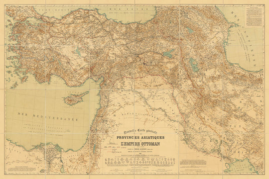
La "Nouvelle Carte générale des Provinces Asiatiques de L'Empire Ottoman" es un cautivador artefacto histórico que ofrece una ventana al paisaje geopolítico de principios del siglo XX. Elaborada por los estimados cartógrafos Dietrich Reimer y Heinrich Keipert en 1912, este mapa es un testimonio del intrincado tapiz político y físico del Imperio Otomano en el umbral de la Primera Guerra Mundial. Las detalladas anotaciones manuscritas del mapa revelan los ambiciosos proyectos ferroviarios que fueron centrales para las aspiraciones coloniales de Alemania, particularmente el Ferrocarril Berlín-Bagdad, que se imaginó para conectar Europa con el Golfo Pérsico, eludiendo el Canal de Suez.
Este mapa cubre una vasta extensión, incluyendo la actual Turquía, el norte de Egipto, Chipre, Israel, Siria, Palestina, Kurdistán, Irak, Kuwait e Irán. Ilustra vívidamente la importancia estratégica de estas regiones, mostrando el Ferrocarril Hejaz y el Ferrocarril Berlín-Bagdad, que fueron fundamentales en la alianza otomano-alemana. El mapa no solo traza ferrocarriles operativos, sino también líneas proyectadas, ofreciendo una visión de los ambiciosos planes de infraestructura que nunca se realizaron completamente debido a las interrupciones de la guerra.
Las características geográficas representadas en el mapa son tan fascinantes como las políticas. El mar Mediterráneo y el mar Caspio enmarcan el paisaje, mientras que varias cadenas montañosas atraviesan el terreno, añadiendo profundidad y textura a las regiones representadas. Estas características naturales eran parte tanto de las consideraciones estratégicas de la época como las artificiales, influyendo en las rutas comerciales, las campañas militares y los patrones de asentamiento a lo largo del imperio.
Ciudades y pueblos como Estambul, Bagdad y Damasco están marcados, cada uno un centro de actividad cultural y económica. Estos asentamientos, impregnados de historia, fueron nodos cruciales en la red de ferrocarriles que el mapa detalla meticulosamente. El mapa sirve como un recordatorio de los bulliciosos centros urbanos que estaban en el corazón del Imperio Otomano, cada uno contribuyendo al rico tapiz de culturas y tradiciones del imperio.
La importancia histórica del mapa es profunda, capturando un momento de transformación y ambición. Refleja las tensiones geopolíticas y alianzas que dieron forma al siglo XX, con las aspiraciones de Alemania de extender su influencia en el Medio Oriente y obtener acceso al Océano Índico. Este mapa no es solo una representación de tierras e infraestructuras; es una narrativa de ambición, conflicto y las siempre cambiantes arenas de la historia.
Ciudades y pueblos en este mapa
- Turquía
- Estambul
- Esmirna
- Ankara
- Irak
- Bagdad
- Basora
- Mosul
- Irán
- Teherán
- Egipto
- El Cairo
- Siria
- Damasco
- Kuwait
- Ciudad de Kuwait
- Israel
- Jerusalén
Características y monumentos notables
- Cuerpos de agua:
- Mar Mediterráneo
- Mar Caspio
- Fronteras: Representa las fronteras del Imperio Otomano y las regiones circundantes.
- Montañas: Varias cadenas montañosas están ilustradas a lo largo del mapa.
Contexto histórico y de diseño
- Nombre del mapa: Nouvelle Carte générale des Provinces Asiatiques de L'Empire Ottoman
- Fecha de creación: 1912, con actualizaciones manuscritas hasta finales de 1914.
- Cartógrafos: Dietrich Reimer & Heinrich Keipert.
- Temas:
- Ferrocarriles de Oriente Medio en la víspera de la Primera Guerra Mundial.
- Anotaciones manuscritas que destacan el Hejaz y el Ferrocarril Berlín-Bagdad.
- El mapa refleja las aspiraciones coloniales de Alemania, particularmente el Ferrocarril Berlín-Bagdad.
- Regiones cubiertas:
- Turquía, norte de Egipto, Chipre, Israel, Siria, Palestina, Kurdistán, Irak, Kuwait, Irán, y más.
- Diseño y estilo:
- Mapa grande, litografiado en color con anotaciones manuscritas detalladas.
- Muestra líneas de ferrocarril operativas y proyectadas.
- Significado histórico:
- Destaca las ambiciones geopolíticas de Alemania y la alianza otomano-alemana durante la Primera Guerra Mundial.
- El Ferrocarril Berlín-Bagdad tenía como objetivo conectar Berlín con el Golfo Pérsico, eludiendo el Canal de Suez.
Por favor, verifica las imágenes para asegurarte de que una ciudad o lugar específico esté mostrado en este mapa. También puedes ponerte en contacto y pedirnos que verifiquemos el mapa por ti.
Este es un mapa muy grande que debe ser pedido en un tamaño grande, para que puedas distinguir fácilmente todos los detalles.
Este mapa se ve increíble en tamaños de hasta 100in (250cm). Si estás buscando un mapa más grande, por favor ponte en contacto.
El modelo en las imágenes del listado sostiene la versión de este mapa de 24x36in (60x90cm).
La quinta imagen del listado muestra un ejemplo de mi servicio de personalización de mapas.
Si estás buscando algo ligeramente diferente, echa un vistazo a mi colección de los mejores mapas antiguos para ver si algo más llama tu atención.
Por favor contáctame para verificar si una ubicación, hito o característica específica está mostrada en este mapa.
Este sería un maravilloso regalo de cumpleaños, Navidad, Día del Padre, despedida laboral, aniversario o inauguración de casa para alguien de las áreas cubiertas por este mapa.
Este mapa está disponible como una impresión giclée en papel mate libre de ácido y de archivo, o puedes comprarlo enmarcado. El marco es un bonito y simple marco negro que se adapta a la mayoría de las estéticas. Por favor, ponte en contacto si deseas un color o material de marco diferente. Mis marcos están envidriados con acrílico de grado museo superclaro (perspex/acrylite), que es significativamente menos reflectante que el vidrio, más seguro, y siempre llegará en perfectas condiciones.
This map is also available as a float framed canvas, sometimes known as a shadow gap framed canvas or canvas floater. The map is printed on artist's cotton canvas and then stretched over a handmade box frame. We then "float" the canvas inside a wooden frame, which is available in a range of colours (black, dark brown, oak, antique gold and white). This is a wonderful way to present a map without glazing in front. See some examples of float framed canvas maps and explore the differences between my different finishes.
For something truly unique, this map is also available in "Unique 3D", our trademarked process that dramatically transforms the map so that it has a wonderful sense of depth. We combine the original map with detailed topography and elevation data, so that mountains and the terrain really "pop". For more info and examples of 3D maps, check my Unique 3D page.
Para la mayoría de los pedidos, el tiempo de entrega es de aproximadamente 3 días laborables. Los productos personalizados y a medida tardan más, ya que tengo que hacer la personalización y enviártelo para su aprobación, lo cual suele tardar 1 o 2 días.
Tenga en cuenta que los pedidos enmarcados muy grandes suelen tardar más en fabricarse y entregarse.
Si necesitas que tu pedido llegue para una fecha determinada, por favor contáctame antes de hacer el pedido para que podamos encontrar la mejor manera de asegurarnos de que recibas tu pedido a tiempo.
Imprimo y enmarco mapas y obras de arte en 23 países alrededor del mundo. Esto significa que tu pedido se fabricará localmente, lo que reduce el tiempo de entrega y asegura que no se dañe durante el envío. Nunca pagarás aranceles de aduana o impuestos de importación, y pondremos menos CO2 en el aire.
Todos mis mapas y impresiones artísticas están bien empaquetados y enviados en un tubo resistente si no están enmarcados, o rodeados de espuma si están enmarcados.
Intento enviar todos los pedidos dentro de 1 o 2 días después de recibir tu pedido, aunque algunos productos (como mascarillas, tazas y bolsas de tela) pueden tardar más en fabricarse.
Si seleccionas Entrega Exprés al finalizar la compra, priorizaremos tu pedido y lo enviaremos por mensajería de 1 día (Fedex, DHL, UPS, Parcelforce).
La entrega al día siguiente también está disponible en algunos países (EE. UU., Reino Unido, Singapur, EAU), pero por favor intenta hacer tu pedido temprano en el día para que podamos enviarlo a tiempo.
Mi marco estándar es un marco de madera de fresno negro estilo galería. Es simple y tiene un aspecto bastante moderno. Mi marco estándar tiene alrededor de 20 mm (0.8 in) de ancho.
Utilizo acrílico super claro (perspex/acrylite) para el vidrio del marco. Es más ligero y seguro que el vidrio, y se ve mejor, ya que la reflectividad es menor.
Seis colores de marco estándar están disponibles de forma gratuita (negro, marrón oscuro, gris oscuro, roble, blanco y oro antiguo).El enmarcado y montaje/matizado personalizado está disponible si buscas algo diferente.
La mayoría de los mapas, arte e ilustraciones también están disponibles como un lienzo enmarcado. Utilizamos lienzo de algodón mate (no brillante), lo estiramos sobre un marco de madera de caja de origen sostenible, y luego 'flotamos' la pieza dentro de un marco de madera. El resultado final es bastante hermoso, y no hay cristal que se interponga.
Todos los marcos se proporcionan "listos para colgar", con una cuerda o soportes en la parte posterior. Los marcos muy grandes tendrán placas de colgar de alta resistencia y/o un listón de montaje. Si tienes alguna pregunta, por favor ponte en contacto.
Mira algunos ejemplos de mis mapas enmarcados y mapas en lienzo enmarcados.
Alternativamente, también puedo proporcionar mapas antiguos y obras de arte en lienzo, tablero de espuma, papel de algodón y otros materiales.
Si deseas enmarcar tu mapa o obra de arte tú mismo, por favor lee mi guía de tamaños primero.
Algunos de mis mapas antiguos ahora están disponibles como lienzos enmarcados. Por favor contáctame si deseas pedir un tamaño que no está disponible en mi tienda.
Los mapas antiguos en lienzo son una alternativa interesante a los mapas enmarcados convencionalmente. Dependiendo de tu gusto personal y la decoración de la habitación, los mapas en lienzo pueden "destacar" un poco más que un mapa enmarcado.
Mis mapas son reproducciones de mapas originales de altísima calidad.
Obtengo mapas originales y raros de bibliotecas, casas de subastas y colecciones privadas de todo el mundo, los restauro en mi taller de Londres y luego uso tintas e impresoras giclée especializadas para crear hermosos mapas que lucen incluso mejor que el original.
Mis mapas están impresos en papel de archivo mate (no brillante) sin ácido que se siente de muy alta calidad y casi como una tarjeta. En términos técnicos, el peso/grosor del papel es de 10 mil/200 g/m². Es perfecto para enmarcar.
Imprimo con tintas pigmentadas Epson ultrachrome giclée UV resistentes a la decoloración, algunas de las mejores tintas que puedes encontrar.
yo también puedo hacer mapas sobre lienzo, trapo de algodón y otros materiales exóticos.
Obtenga más información sobre The Unique Maps Co..
Personalización de mapas
Si está buscando el regalo perfecto de aniversario o inauguración de la casa, puedo personalizar su mapa para hacerlo verdaderamente único. Por ejemplo, puedo agregar un mensaje corto, resaltar una ubicación importante o agregar el escudo de armas de su familia.
Las opciones son casi infinitas. Por favor mira mi página de personalización de mapas para ver algunos maravillosos ejemplos de lo que es posible.
Para pedir un mapa personalizado, seleccione "personalizar su mapa" antes de agregarlo a su carrito.
Ponerse en contacto si buscas personalizaciones y personalizaciones más complejas.
Envejecimiento del mapa
A lo largo de los años, los clientes me han preguntado cientos de veces si podían comprar un mapa que se viera uniforme. más viejo.
Bueno, ahora puedes hacerlo seleccionando Envejecido antes de agregar un mapa a tu carrito.
Todas las fotografías de productos que ve en esta página muestran el mapa en su forma original. Así es como se ve el mapa hoy.
Si selecciona Envejecido, envejeceré su mapa a mano, usando un proceso especial y único desarrollado a través de años de estudiar mapas antiguos, hablar con investigadores para comprender la química del envejecimiento del papel y, por supuesto... ¡mucha práctica!
Si no estás seguro, quédate con el color original del mapa. Si quieres algo un poco más oscuro y más viejo buscando, opte por Envejecido.
Si no estás satisfecho con tu pedido por cualquier motivo, contáctame para un reembolso sin complicaciones. Por favor, consulta nuestra política de devoluciones y reembolsos para más información.
Estoy muy seguro de que te gustará tu mapa o impresión artística restaurada. He estado haciendo esto desde 1984. Soy un vendedor de 5 estrellas en Etsy. He vendido decenas de miles de mapas e impresiones artísticas y tengo más de 5,000 opiniones reales de 5 estrellas.
Utilizo un proceso único para restaurar mapas y obras de arte que consume mucho tiempo y mano de obra. Buscar los mapas e ilustraciones originales puede llevar meses. Utilizo tecnología de última generación y extremadamente cara para escanear y restaurarlos. Como resultado, garantizo que mis mapas e impresiones artísticas son superiores a los demás - por eso puedo ofrecer un reembolso sin complicaciones.
Casi todos mis mapas e impresiones artísticas se ven increíbles en tamaños grandes (200cm, 6.5ft+) y también puedo enmarcarlos y entregártelos a través de un servicio de mensajería especial para tamaños grandes. Contáctame para discutir tus necesidades específicas.
Or try searching for something!


