


Mapa de las antiguas leyendas del folclore de EE. UU., 1960
20% de descuento en 2 — 33% de descuento en 3
Añade dos artículos elegibles a tu carrito para recibir 20% de descuento. Añade un tercero y será complementario (equivalente a 33% de descuento al comprar tres).
No se necesita código — la oferta se aplica automáticamente al finalizar la compra.
Válido en todos los mapas estándar y impresiones de arte fino. Puedes mezclar y combinar cualquier diseño.
Si deseas enviar artículos a múltiples direcciones, por favor contáctanos antes de realizar tu pedido.
Las comisiones personalizadas y a medida están excluidas.
Contáctanos si tienes alguna pregunta
 Diseñado en Londres Hecho en Canada
Diseñado en Londres • Hecho en Canada
Diseñado en Londres Hecho en Canada
Diseñado en Londres • Hecho en Canada

Choose your size
Choose your finish


(Más información)
Mensaje de regalo y acabado personalizado

Si deseas agregar un mensaje de regalo, o un acabado (rompecabezas, tablero de aluminio, etc.) que no esté disponible aquí, por favor solicítalo en la "nota del pedido" cuando realices la compra.
Cada pedido es hecho a medida, así que si necesitas que el tamaño se ajuste ligeramente, o que se imprima en un material inusual, háznoslo saber. Hemos realizado miles de pedidos personalizados a lo largo de los años, así que hay (casi) nada que no podamos gestionar.
También puedes contactarnos antes de hacer tu pedido, ¡si lo prefieres!

- Made locally for fast, safe delivery
- No import duty or hidden fees
- Need advice? Message us on WhatsApp
Own a piece of history
7,000+ 5 star reviews


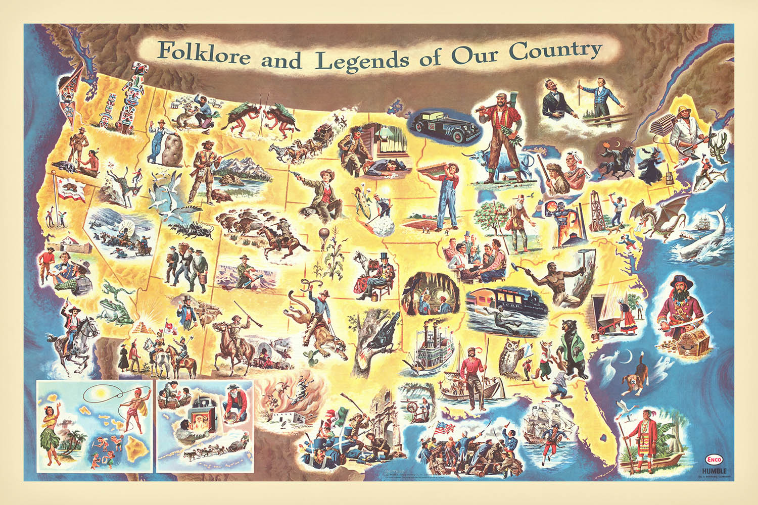
Adéntrese en el vibrante mundo de la América de mediados de siglo con el cautivador pictórico de 1960 de Frank J. Soltesz, "Folklore and Legends of Our Country." Este excepcional mapa temático ofrece un recorrido caprichoso pero profundamente informativo por los Estados Unidos, donde cada estado estalla en color y carácter, narrando su propia combinación única de historia, leyenda y mito. Diseñado con atención tanto a la educación como al entretenimiento, la creación de Soltesz atrae al espectador a un animado cuadro en el que se entremezclan el hecho y el folclore, convirtiéndolo en un valioso objeto para coleccionistas y conocedores de la historia cultural estadounidense.
Frank J. Soltesz, célebre por sus atractivos mapas pictóricos, fue un maestro captando la imaginación de jóvenes y mayores. Su obra es testimonio de la edad de oro de los mapas de gasolina—esos encantadores acompañantes cartográficos distribuidos en las estaciones de servicio para despertar la curiosidad y el deseo de viajar de los automovilistas. El estilo distintivo de Soltesz, caracterizado por ilustraciones ricamente detalladas y un enfoque lúdico pero informativo, garantiza que cada contemplación revele nuevas historias y personajes. Sus mapas son más que herramientas de navegación; son portales a la memoria colectiva y a la imaginación de una nación.
El mapa en sí es un festín visual, rebosante de figuras legendarias como Paul Bunyan, Pecos Bill, Johnny Appleseed y Davy Crockett, todas representadas en ilustraciones vívidas de estilo caricaturesco. Grandes acontecimientos históricos, desde el Boston Tea Party hasta la Fiebre del Oro, se muestran junto a criaturas míticas como el jackalope y el Jersey Devil, ofreciendo una deliciosa mezcla de realidad y ficción. Maravillas naturales como las cataratas del Niágara, el Gran Cañón y Mount Rushmore se celebran con igual énfasis, inmortalizando su grandeza en la mano vivaz de Soltesz. Cada estado está minuciosamente delimitado y rotulado, haciendo del mapa una pieza tan informativa como encantadora.
Más allá de su atractivo artístico, el mapa ofrece un rico tapiz de la geografía de Estados Unidos. El poderoso río Misisipi serpentea por el corazón del país, los Grandes Lagos resplandecen en el norte, y las Montañas Rocosas y los Apalaches se alzan majestuosamente sobre el paisaje. El océano Atlántico y el océano Pacífico, el golfo de México y las fronteras del país con Canadá y México están todos elegantemente delineados, anclando el folclore en un sentido tangible del lugar. Esta atención a la geografía física refuerza el poder narrativo del mapa, invitando a los espectadores a explorar la interacción entre la tierra y la leyenda.
Las ciudades y localidades se seleccionan cuidadosamente por su importancia histórica y cultural, con Nueva York, Los Ángeles, Chicago y San Francisco junto a lugares cargados de historia como Boston, Nueva Orleans y Santa Fe. Cada asentamiento no es solo un punto en el mapa, sino un referente de los relatos y tradiciones que definen la experiencia estadounidense. "Folklore and Legends of Our Country" de Soltesz es más que un mapa—es una celebración de las historias, los paisajes y el espíritu que han dado forma a los Estados Unidos, convirtiéndolo en una incorporación extraordinaria a cualquier colección de arte cartográfico.
Ciudades y localidades en este mapa
- Nueva York
- Los Ángeles
- Chicago
- Houston
- Filadelfia
- San Francisco
- Boston
- Nueva Orleans
- St. Louis
- Salt Lake City
- Santa Fe
- Plymouth
Características destacadas y monumentos
- Ilustraciones de figuras legendarias y personajes del folclore (p. ej., Paul Bunyan, Pecos Bill, Johnny Appleseed, Davy Crockett, Daniel Boone)
Contexto histórico y de diseño
- Creado por Frank J. Soltesz en 1960, un maestro de los atractivos mapas pictóricos
- El mapa es un mapa pictórico de "gasolina", distribuido en estaciones de servicio para atraer a los viajeros, especialmente a los niños
- Ilustra, estado por estado, grandes acontecimientos de la historia de Estados Unidos, combinando folclore, leyendas y hechos históricos destacados
- Orientado a los niños, ofreciendo una visión animada y a veces políticamente incorrecta de la historia de Estados Unidos
- Ricamente ilustrado con dibujos coloridos, de estilo caricaturesco, que representan diversas leyendas, acontecimientos históricos y personajes
- Cubre los Estados Unidos de América, con cada estado ilustrado y rotulado individualmente
- Refleja las perspectivas estadounidenses de mediados del siglo XX sobre la historia y el folclore
- Similar en temática a American Folklore and Legend (1950) de John Dukes McKee
- Un artefacto visual de cómo la historia y el folclore estadounidenses se presentaban al público en la década de 1960, combinando entretenimiento y educación
Por favor, revise cuidadosamente las imágenes para asegurarse de que se muestra una ciudad o lugar específico en este mapa. También puede ponerse en contacto con nosotros y pedirnos que revisemos el mapa por usted.
Este mapa luce estupendo en cualquier tamaño, pero siempre recomiendo optar por un tamaño mayor si dispone de espacio. Así podrá apreciar fácilmente todos los detalles.
Este mapa luce increíble en tamaños de hasta 100in (250cm). Si busca un mapa más grande, por favor póngase en contacto.
Nota: las etiquetas de este mapa son difíciles de leer si pide un mapa de 20in (50cm) o menos. El mapa sigue siendo muy atractivo, pero si desea leerlo con facilidad, le recomendamos comprar un tamaño mayor.
La modelo en las imágenes del anuncio sostiene la versión de 24x36in (60x90cm) de este mapa.
La quinta imagen del anuncio muestra un ejemplo de mi servicio de personalización de mapas.
Si busca algo ligeramente distinto, consulte mi colección de los mejores mapas antiguos para ver si algo más llama su atención.
Por favor, contácteme para comprobar si una determinada ubicación, hito o elemento aparece en este mapa.
Sería un regalo maravilloso de cumpleaños, Navidad, Día del Padre, despedida del trabajo, aniversario o inauguración de casa para alguien de las zonas cubiertas por este mapa.
Este mapa está disponible como impresión giclée sobre papel mate de archivo libre de ácido, o puede comprarlo enmarcado. El marco es un bonito y sencillo marco negro que se adapta a la mayoría de estilos. Póngase en contacto si desea otro color o material para el marco. Mis marcos están acristalados con acrílico de calidad museística de gran nitidez (perspex/acrylite), que es significativamente menos reflectante que el vidrio, más seguro y siempre llegará en perfectas condiciones.
This map is also available as a float framed canvas, sometimes known as a shadow gap framed canvas or canvas floater. The map is printed on artist's cotton canvas and then stretched over a handmade box frame. We then "float" the canvas inside a wooden frame, which is available in a range of colours (black, dark brown, oak, antique gold and white). This is a wonderful way to present a map without glazing in front. See some examples of float framed canvas maps and explore the differences between my different finishes.
For something truly unique, this map is also available in "Unique 3D", our trademarked process that dramatically transforms the map so that it has a wonderful sense of depth. We combine the original map with detailed topography and elevation data, so that mountains and the terrain really "pop". For more info and examples of 3D maps, check my Unique 3D page.
Many of our maps and art prints are chosen as thoughtful gifts for homes, offices, studies and meaningful places.
Choose a framed option for the easiest ready-to-hang gift, or choose an unframed print if the recipient may prefer to select their own frame.
We make orders locally in 23 countries around the world, so gifts can often be produced close to the recipient. This helps them arrive faster, travel more safely, and avoid customs or import duty surprises.
- We can deliver directly to the recipient
- Framed pieces arrive ready to hang
- Unframed prints are carefully packed in a strong protective tube
- Almost every order is made locally, for faster, safer gifting
- 90-day returns give the recipient time to decide
If you are not sure what to choose, please contact us. We can help you pick the right map, size, finish or delivery option.
Para la mayoría de los pedidos, el tiempo de entrega es de aproximadamente 3 días laborables. Los productos personalizados y a medida tardan más, ya que tengo que hacer la personalización y enviártelo para su aprobación, lo cual suele tardar 1 o 2 días.
Tenga en cuenta que los pedidos enmarcados muy grandes suelen tardar más en fabricarse y entregarse.
Si necesitas que tu pedido llegue para una fecha determinada, por favor contáctame antes de hacer el pedido para que podamos encontrar la mejor manera de asegurarnos de que recibas tu pedido a tiempo.
Imprimo y enmarco mapas y obras de arte en 23 países alrededor del mundo. Esto significa que tu pedido se fabricará localmente, lo que reduce el tiempo de entrega y asegura que no se dañe durante el envío. Nunca pagarás aranceles de aduana o impuestos de importación, y pondremos menos CO2 en el aire.
Todos mis mapas y impresiones artísticas están bien empaquetados y enviados en un tubo resistente si no están enmarcados, o rodeados de espuma si están enmarcados.
Intento enviar todos los pedidos dentro de 1 o 2 días después de recibir tu pedido, aunque algunos productos (como mascarillas, tazas y bolsas de tela) pueden tardar más en fabricarse.
Si seleccionas Entrega Exprés al finalizar la compra, priorizaremos tu pedido y lo enviaremos por mensajería de 1 día (Fedex, DHL, UPS, Parcelforce).
La entrega al día siguiente también está disponible en algunos países (EE. UU., Reino Unido, Singapur, EAU), pero por favor intenta hacer tu pedido temprano en el día para que podamos enviarlo a tiempo.
Mi marco estándar es un marco de madera de fresno negro estilo galería. Es simple y tiene un aspecto bastante moderno. Mi marco estándar tiene alrededor de 20 mm (0.8 in) de ancho.
Utilizo acrílico super claro (perspex/acrylite) para el vidrio del marco. Es más ligero y seguro que el vidrio, y se ve mejor, ya que la reflectividad es menor.
Seis colores de marco estándar están disponibles de forma gratuita (negro, marrón oscuro, gris oscuro, roble, blanco y oro antiguo).El enmarcado y montaje/matizado personalizado está disponible si buscas algo diferente.
La mayoría de los mapas, arte e ilustraciones también están disponibles como un lienzo enmarcado. Utilizamos lienzo de algodón mate (no brillante), lo estiramos sobre un marco de madera de caja de origen sostenible, y luego 'flotamos' la pieza dentro de un marco de madera. El resultado final es bastante hermoso, y no hay cristal que se interponga.
Todos los marcos se proporcionan "listos para colgar", con una cuerda o soportes en la parte posterior. Los marcos muy grandes tendrán placas de colgar de alta resistencia y/o un listón de montaje. Si tienes alguna pregunta, por favor ponte en contacto.
Mira algunos ejemplos de mis mapas enmarcados y mapas en lienzo enmarcados.
Alternativamente, también puedo proporcionar mapas antiguos y obras de arte en lienzo, tablero de espuma, papel de algodón y otros materiales.
Si deseas enmarcar tu mapa o obra de arte tú mismo, por favor lee mi guía de tamaños primero.
Mis mapas son reproducciones de mapas originales de altísima calidad.
Obtengo mapas originales y raros de bibliotecas, casas de subastas y colecciones privadas de todo el mundo, los restauro en mi taller de Londres y luego uso tintas e impresoras giclée especializadas para crear hermosos mapas que lucen incluso mejor que el original.
Mis mapas están impresos en papel de archivo mate (no brillante) sin ácido que se siente de muy alta calidad y casi como una tarjeta. En términos técnicos, el peso/grosor del papel es de 10 mil/200 g/m². Es perfecto para enmarcar.
Imprimo con tintas pigmentadas Epson ultrachrome giclée UV resistentes a la decoloración, algunas de las mejores tintas que puedes encontrar.
yo también puedo hacer mapas sobre lienzo, trapo de algodón y otros materiales exóticos.
Obtenga más información sobre The Unique Maps Co..
Personalización de mapas
Si está buscando el regalo perfecto de aniversario o inauguración de la casa, puedo personalizar su mapa para hacerlo verdaderamente único. Por ejemplo, puedo agregar un mensaje corto, resaltar una ubicación importante o agregar el escudo de armas de su familia.
Las opciones son casi infinitas. Por favor mira mi página de personalización de mapas para ver algunos maravillosos ejemplos de lo que es posible.
Para pedir un mapa personalizado, seleccione "personalizar su mapa" antes de agregarlo a su carrito.
Ponerse en contacto si buscas personalizaciones y personalizaciones más complejas.
Envejecimiento del mapa
A lo largo de los años, los clientes me han preguntado cientos de veces si podían comprar un mapa que se viera uniforme. más viejo.
Bueno, ahora puedes hacerlo seleccionando Envejecido antes de agregar un mapa a tu carrito.
Todas las fotografías de productos que ve en esta página muestran el mapa en su forma original. Así es como se ve el mapa hoy.
Si selecciona Envejecido, envejeceré su mapa a mano, usando un proceso especial y único desarrollado a través de años de estudiar mapas antiguos, hablar con investigadores para comprender la química del envejecimiento del papel y, por supuesto... ¡mucha práctica!
Si no estás seguro, quédate con el color original del mapa. Si quieres algo un poco más oscuro y más viejo buscando, opte por Envejecido.
Si no estás satisfecho con tu pedido por cualquier motivo, contáctame para un reembolso sin complicaciones. Por favor, consulta nuestra política de devoluciones y reembolsos para más información.
Estoy muy seguro de que te gustará tu mapa o impresión artística restaurada. He estado haciendo esto desde 1984. Soy un vendedor de 5 estrellas en Etsy. He vendido decenas de miles de mapas e impresiones artísticas y tengo más de 5,000 opiniones reales de 5 estrellas.
Utilizo un proceso único para restaurar mapas y obras de arte que consume mucho tiempo y mano de obra. Buscar los mapas e ilustraciones originales puede llevar meses. Utilizo tecnología de última generación y extremadamente cara para escanear y restaurarlos. Como resultado, garantizo que mis mapas e impresiones artísticas son superiores a los demás - por eso puedo ofrecer un reembolso sin complicaciones.
Casi todos mis mapas e impresiones artísticas se ven increíbles en tamaños grandes (200cm, 6.5ft+) y también puedo enmarcarlos y entregártelos a través de un servicio de mensajería especial para tamaños grandes. Contáctame para discutir tus necesidades específicas.
Or try searching for something!


