


Antiguo mapa de Halifax, Terranova, Nueva Escocia y Nuevo Brunswick, de Bartholomew, 1922
20% de descuento en 2 — 33% de descuento en 3
Añade dos artículos elegibles a tu carrito para recibir 20% de descuento. Añade un tercero y será complementario (equivalente a 33% de descuento al comprar tres).
No se necesita código — la oferta se aplica automáticamente al finalizar la compra.
Válido en todos los mapas estándar y impresiones de arte fino. Puedes mezclar y combinar cualquier diseño.
Si deseas enviar artículos a múltiples direcciones, por favor contáctanos antes de realizar tu pedido.
Las comisiones personalizadas y a medida están excluidas.
Contáctanos si tienes alguna pregunta
 Diseñado en Londres Hecho en Canada
Diseñado en Londres • Hecho en Canada
Diseñado en Londres Hecho en Canada
Diseñado en Londres • Hecho en Canada

Restaurado a partir del mapa original de 1922 e impreso en calidad museo. Leer la historia detrás de este mapa
Choose your size
Choose your finish


(Más información)
Mensaje de regalo y acabado personalizado

Si deseas agregar un mensaje de regalo, o un acabado (rompecabezas, tablero de aluminio, etc.) que no esté disponible aquí, por favor solicítalo en la "nota del pedido" cuando realices la compra.
Cada pedido es hecho a medida, así que si necesitas que el tamaño se ajuste ligeramente, o que se imprima en un material inusual, háznoslo saber. Hemos realizado miles de pedidos personalizados a lo largo de los años, así que hay (casi) nada que no podamos gestionar.
También puedes contactarnos antes de hacer tu pedido, ¡si lo prefieres!

- Hecho localmente. Entrega segura
- Sin aranceles ni cargos ocultos
- ¿Necesitas ayuda? Llámanos o mensaje por WhatsApp
Own a piece of history
8,000+ five-star reviews


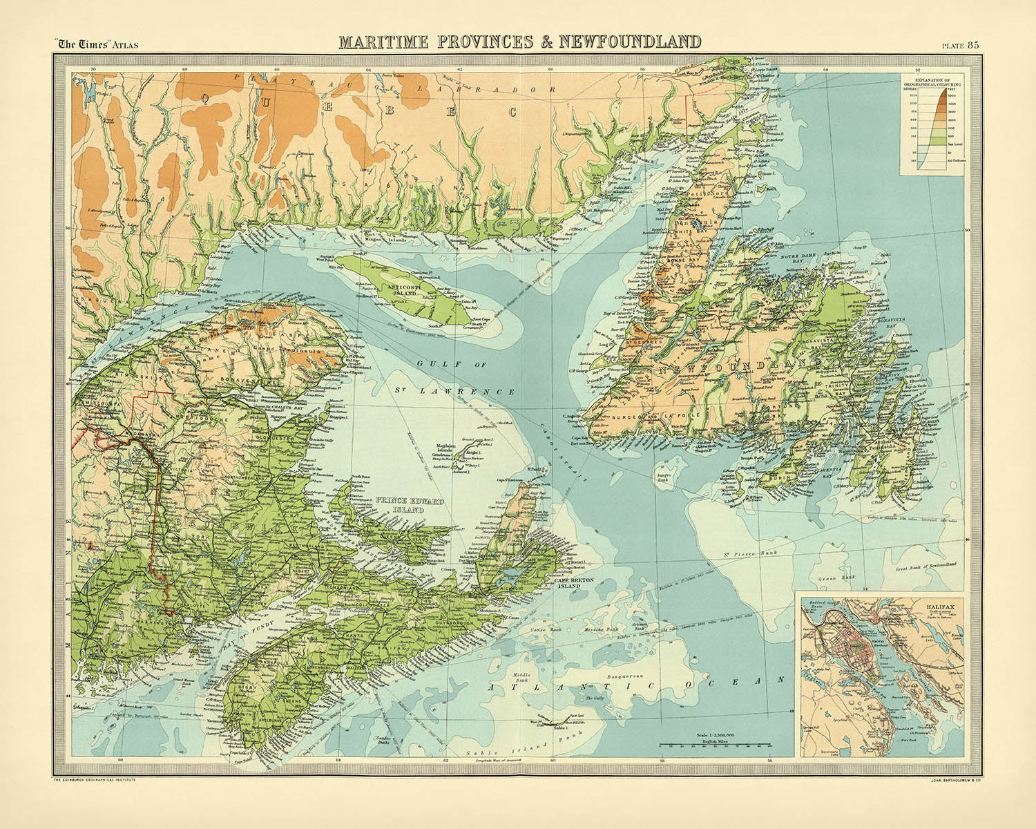
Sumérjase en el legado marítimo del Canadá de principios del siglo XX con "Maritime Provinces & Newfoundland", una obra cartográfica maestra de...
Seguir leyendoSumérjase en el legado marítimo del Canadá de principios del siglo XX con "Maritime Provinces & Newfoundland", una obra cartográfica maestra de 1922 del célebre John George Bartholomew. Este exquisito mapa, publicado originalmente en el estimado Times Atlas & Gazetteer of the World, marca una transición decisiva en el arte y la ciencia de la cartografía. La visión de Bartholomew dio paso a una nueva era de precisión y elegancia, sustituyendo los anteriores mapas de Andree de 1895 y estableciendo un nuevo estándar para la erudición geográfica. La detallada representación del mapa de las Provincias Marítimas—Nueva Escocia, Nuevo Brunswick, la Isla del Príncipe Eduardo—y del entonces independiente Terranova, captura una región moldeada por siglos de navegación, comercio e intercambio cultural.
La maestría de Bartholomew es inmediatamente evidente en el uso de tintes hipsométricos, una técnica sofisticada que emplea gradaciones de color para revelar las sutiles ondulaciones del terreno. La geografía física de la región cobra vida, desde las boscosas Tierras Altas de Cape Breton hasta las onduladas colinas y los valles fluviales de Nuevo Brunswick. El sombreado batimétrico resalta con nitidez los mares circundantes, con las dramáticas profundidades de la bahía de Fundy y del golfo de San Lorenzo representadas con cautivador detalle. La meticulosa coloración a mano y la elegante tipografía del mapa evocan la época dorada de la producción de atlas, convirtiéndolo tanto en una obra de arte como en una herramienta de navegación.
Más allá de su atractivo visual, este mapa es un documento de un momento histórico transformador. Creado cuando Terranova aún era un dominio independiente, presenta los límites políticos y las divisiones por condados de una región en vísperas de un cambio. Las rutas marítimas señaladas, con distancias precisas, hablan de la perdurable importancia del comercio marítimo y de los ritmos cotidianos de la vida moldeados por el Atlántico. Con un recuadro que incluye un detallado plano de Halifax—entonces, como ahora, una bulliciosa ciudad portuaria—el mapa ofrece tanto una amplia visión general como un estudio específico de uno de los centros urbanos más vitales de la región.
La superficie del mapa es un tapiz de asentamientos humanos y maravillas naturales. Desde las célebres ciudades de Halifax, Saint John y St. John’s hasta las poblaciones más pequeñas que salpican las costas y las riberas, cada comunidad está cuidadosamente inscrita, dando testimonio del crecimiento y la diversidad de las provincias Marítimas. Ríos principales como el Saint John y el Miramichi trazan su curso a través del paisaje, mientras que las intrincadas costas de la isla Cape Breton, la península de Avalon y la Isla del Príncipe Eduardo se representan con la amorosa precisión de un cartógrafo. Cabe señalar que la ausencia de parques nacionales o hitos históricos refleja el enfoque propio de su época; sin embargo, la tierra y el mar mismos se erigen como monumentos perdurables del rico patrimonio natural y cultural de la región.
John George Bartholomew, a menudo aclamado como "el Príncipe de los Cartógrafos", impregnó este mapa de rigor científico y gracia artística. Su obra pionera en la cartografía temática y física se exhibe plenamente, ofreciendo una ventana al cambiante entendimiento de las provincias más orientales de Canadá. Este mapa no es solo un registro de la geografía: es un testimonio de la curiosidad intelectual de la época, la innovación técnica y el atractivo atemporal de la exploración. Para coleccionistas y conocedores, "Maritime Provinces & Newfoundland" es una oportunidad excepcional de poseer una pieza de la historia cartográfica, cargada con las historias de la tierra, el mar y las personas que han llamado hogar a esta región.
Cities and towns on this map
- Nueva Escocia
- Halifax
- Sydney
- New Glasgow
- Truro
- Amherst
- Kentville
- Yarmouth
- Bridgewater
- Antigonish
-
Windsor
-
Nueva Brunswick
- Moncton
- Saint John
- Fredericton
- Bathurst
- Edmundston
- Campbellton
- Miramichi (then Chatham/Newcastle)
- Sackville
-
Woodstock
-
Isla del Príncipe Eduardo
- Charlottetown
-
Summerside
-
Terranova (ahora Terranova y Labrador)
- St. John’s
- Corner Brook
- Grand Falls (ahora Grand Falls-Windsor)
- Gander
Características destacadas y lugares de interés
- Límites provinciales de Nueva Escocia, Nueva Brunswick, Isla del Príncipe Eduardo y Terranova
- Límites de condado dentro de cada provincia, claramente delimitados
- Principales ríos, incluidos el río Saint John y el río Miramichi
- Bahía de Fundy, conocida por su notable rango de mareas
- Golfo de San Lorenzo, una importante vía marítima
- Estrecho de Cabot, el canal entre Terranova y la isla Cape Breton
- Sombreado batimétrico que indica la plataforma continental y las características submarinas
- Rutas marítimas a través del Atlántico Norte, con distancias marcadas
- Mapa detallado insertado de Halifax y su puerto
- Elementos costeros como la isla Cape Breton, el istmo de Chignecto y la península de Avalon
- Numerosas islas, incluidas la Isla del Príncipe Eduardo y las islas Magdalen
- Faros y ayudas a la navegación señalados a lo largo de las costas
- Altitudes puntuales que indican elevaciones destacadas, como las Tierras Altas de Cape Breton
- Áreas boscosas y montañosas representadas mediante sombreado de color
Contexto histórico y de diseño
- Título original: Maritime Provinces & Newfoundland
- Creado por el renombrado cartógrafo británico John George Bartholomew en 1922
- Publicado como parte de "The Times Atlas & Gazetteer of the World", representando un importante avance en la tecnología y precisión cartográfica
- Primera edición del Times Atlas en utilizar los mapas de Bartholomew, sustituyendo los mapas anteriores de Andree de 1895
- Escala: 1:1,500,000, que permite una exploración y consulta detalladas
- Utiliza tintes hipsométricos (sombreado de color) y altitudes puntuales para ilustrar la elevación del terreno
- Los tintes batimétricos muestran las características submarinas y las profundidades marinas
- Refleja las fronteras políticas y las divisiones de condados de la época, incluida Terranova como dominio separado (antes de 1949)
- Subraya tanto las fronteras políticas como la geografía física
- Representa la naturaleza evolutiva del conocimiento y la representación geográfica a principios del siglo XX
Por favor, compruebe las imágenes para asegurarse de que un pueblo o lugar específico aparece en este mapa. También puede ponerse en contacto con nosotros y pedirnos que revisemos el mapa por usted.
Este mapa luce estupendo en cualquier tamaño, pero siempre recomiendo elegir un tamaño mayor si dispone de espacio. Así podrá apreciar fácilmente todos los detalles.
Este mapa luce increíble en tamaños de hasta 70in (180cm). Si busca un mapa más grande, por favor póngase en contacto.
La modelo de las imágenes del anuncio sostiene la versión de 16x20in (40x50cm) de este mapa.
La quinta imagen del anuncio muestra un ejemplo de mi servicio de personalización de mapas.
Si busca algo ligeramente distinto, explore mi colección de los mejores mapas antiguos para ver si algo más le llama la atención.
Por favor, contácteme para comprobar si una determinada ubicación, punto de interés o elemento aparece en este mapa.
Este sería un regalo maravilloso de cumpleaños, Navidad, Día del Padre, despedida laboral, aniversario o inauguración del hogar para alguien de las zonas abarcadas por este mapa.
Este mapa está disponible como impresión giclée en papel mate de archivo libre de ácido, o puede adquirirlo enmarcado. El marco es un marco negro, sencillo y elegante, que se adapta a la mayoría de los estilos decorativos. Póngase en contacto si desea un color o material de marco diferente. Mis marcos están acristalados con acrílico de calidad museística de gran transparencia (perspex/acrylite), que refleja mucho menos que el vidrio, es más seguro y siempre llegará en perfectas condiciones.
This map is also available as a float framed canvas, sometimes known as a shadow gap framed canvas or canvas floater. The map is printed on artist's cotton canvas and then stretched over a handmade box frame. We then "float" the canvas inside a wooden frame, which is available in a range of colours (black, dark brown, oak, antique gold and white). This is a wonderful way to present a map without glazing in front. See some examples of float framed canvas maps and explore the differences between my different finishes.
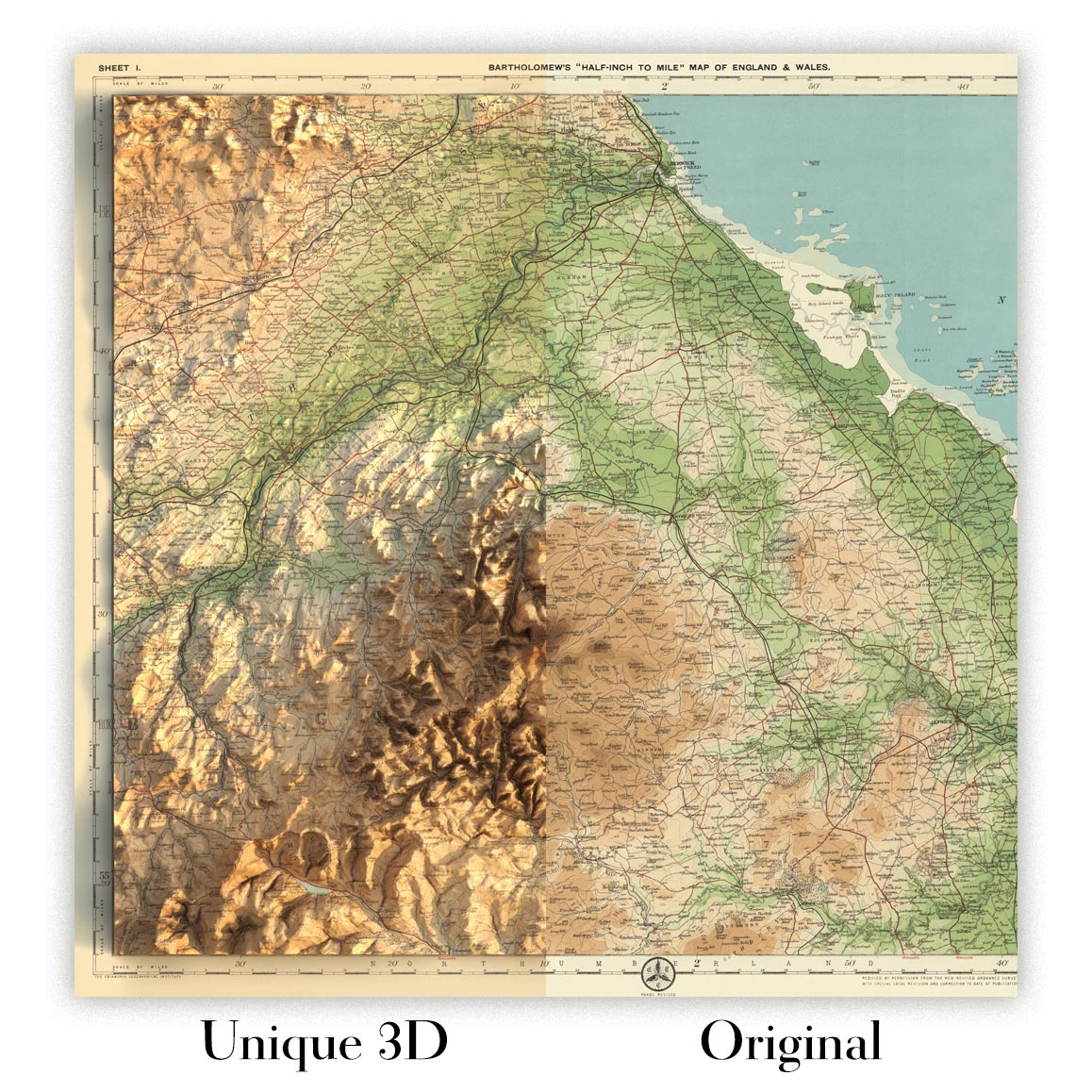
For something truly unique, this map is also available in "Unique 3D", our trademarked process that dramatically transforms the map so that it has a wonderful sense of depth. We combine the original map with detailed topography and elevation data, so that mountains and the terrain really "pop". For more info and examples of 3D maps, check my Unique 3D page.
Sumérjase en el legado marítimo del Canadá de principios del siglo XX con "Maritime Provinces & Newfoundland", una obra cartográfica maestra de 1922 del célebre John George Bartholomew. Este exquisito mapa, publicado originalmente en el estimado Times Atlas & Gazetteer of the World, marca una transición decisiva en el arte y la ciencia de la cartografía. La visión de Bartholomew dio paso a una nueva era de precisión y elegancia, sustituyendo los anteriores mapas de Andree de 1895 y estableciendo un nuevo estándar para la erudición geográfica. La detallada representación del mapa de las Provincias Marítimas—Nueva Escocia, Nuevo Brunswick, la Isla del Príncipe Eduardo—y del entonces independiente Terranova, captura una región moldeada por siglos de navegación, comercio e intercambio cultural.
La maestría de Bartholomew es inmediatamente evidente en el uso de tintes hipsométricos, una técnica sofisticada que emplea gradaciones de color para revelar las sutiles ondulaciones del terreno. La geografía física de la región cobra vida, desde las boscosas Tierras Altas de Cape Breton hasta las onduladas colinas y los valles fluviales de Nuevo Brunswick. El sombreado batimétrico resalta con nitidez los mares circundantes, con las dramáticas profundidades de la bahía de Fundy y del golfo de San Lorenzo representadas con cautivador detalle. La meticulosa coloración a mano y la elegante tipografía del mapa evocan la época dorada de la producción de atlas, convirtiéndolo tanto en una obra de arte como en una herramienta de navegación.
Más allá de su atractivo visual, este mapa es un documento de un momento histórico transformador. Creado cuando Terranova aún era un dominio independiente, presenta los límites políticos y las divisiones por condados de una región en vísperas de un cambio. Las rutas marítimas señaladas, con distancias precisas, hablan de la perdurable importancia del comercio marítimo y de los ritmos cotidianos de la vida moldeados por el Atlántico. Con un recuadro que incluye un detallado plano de Halifax—entonces, como ahora, una bulliciosa ciudad portuaria—el mapa ofrece tanto una amplia visión general como un estudio específico de uno de los centros urbanos más vitales de la región.
La superficie del mapa es un tapiz de asentamientos humanos y maravillas naturales. Desde las célebres ciudades de Halifax, Saint John y St. John’s hasta las poblaciones más pequeñas que salpican las costas y las riberas, cada comunidad está cuidadosamente inscrita, dando testimonio del crecimiento y la diversidad de las provincias Marítimas. Ríos principales como el Saint John y el Miramichi trazan su curso a través del paisaje, mientras que las intrincadas costas de la isla Cape Breton, la península de Avalon y la Isla del Príncipe Eduardo se representan con la amorosa precisión de un cartógrafo. Cabe señalar que la ausencia de parques nacionales o hitos históricos refleja el enfoque propio de su época; sin embargo, la tierra y el mar mismos se erigen como monumentos perdurables del rico patrimonio natural y cultural de la región.
John George Bartholomew, a menudo aclamado como "el Príncipe de los Cartógrafos", impregnó este mapa de rigor científico y gracia artística. Su obra pionera en la cartografía temática y física se exhibe plenamente, ofreciendo una ventana al cambiante entendimiento de las provincias más orientales de Canadá. Este mapa no es solo un registro de la geografía: es un testimonio de la curiosidad intelectual de la época, la innovación técnica y el atractivo atemporal de la exploración. Para coleccionistas y conocedores, "Maritime Provinces & Newfoundland" es una oportunidad excepcional de poseer una pieza de la historia cartográfica, cargada con las historias de la tierra, el mar y las personas que han llamado hogar a esta región.
Cities and towns on this map
- Nueva Escocia
- Halifax
- Sydney
- New Glasgow
- Truro
- Amherst
- Kentville
- Yarmouth
- Bridgewater
- Antigonish
-
Windsor
-
Nueva Brunswick
- Moncton
- Saint John
- Fredericton
- Bathurst
- Edmundston
- Campbellton
- Miramichi (then Chatham/Newcastle)
- Sackville
-
Woodstock
-
Isla del Príncipe Eduardo
- Charlottetown
-
Summerside
-
Terranova (ahora Terranova y Labrador)
- St. John’s
- Corner Brook
- Grand Falls (ahora Grand Falls-Windsor)
- Gander
Características destacadas y lugares de interés
- Límites provinciales de Nueva Escocia, Nueva Brunswick, Isla del Príncipe Eduardo y Terranova
- Límites de condado dentro de cada provincia, claramente delimitados
- Principales ríos, incluidos el río Saint John y el río Miramichi
- Bahía de Fundy, conocida por su notable rango de mareas
- Golfo de San Lorenzo, una importante vía marítima
- Estrecho de Cabot, el canal entre Terranova y la isla Cape Breton
- Sombreado batimétrico que indica la plataforma continental y las características submarinas
- Rutas marítimas a través del Atlántico Norte, con distancias marcadas
- Mapa detallado insertado de Halifax y su puerto
- Elementos costeros como la isla Cape Breton, el istmo de Chignecto y la península de Avalon
- Numerosas islas, incluidas la Isla del Príncipe Eduardo y las islas Magdalen
- Faros y ayudas a la navegación señalados a lo largo de las costas
- Altitudes puntuales que indican elevaciones destacadas, como las Tierras Altas de Cape Breton
- Áreas boscosas y montañosas representadas mediante sombreado de color
Contexto histórico y de diseño
- Título original: Maritime Provinces & Newfoundland
- Creado por el renombrado cartógrafo británico John George Bartholomew en 1922
- Publicado como parte de "The Times Atlas & Gazetteer of the World", representando un importante avance en la tecnología y precisión cartográfica
- Primera edición del Times Atlas en utilizar los mapas de Bartholomew, sustituyendo los mapas anteriores de Andree de 1895
- Escala: 1:1,500,000, que permite una exploración y consulta detalladas
- Utiliza tintes hipsométricos (sombreado de color) y altitudes puntuales para ilustrar la elevación del terreno
- Los tintes batimétricos muestran las características submarinas y las profundidades marinas
- Refleja las fronteras políticas y las divisiones de condados de la época, incluida Terranova como dominio separado (antes de 1949)
- Subraya tanto las fronteras políticas como la geografía física
- Representa la naturaleza evolutiva del conocimiento y la representación geográfica a principios del siglo XX
Por favor, compruebe las imágenes para asegurarse de que un pueblo o lugar específico aparece en este mapa. También puede ponerse en contacto con nosotros y pedirnos que revisemos el mapa por usted.
Este mapa luce estupendo en cualquier tamaño, pero siempre recomiendo elegir un tamaño mayor si dispone de espacio. Así podrá apreciar fácilmente todos los detalles.
Este mapa luce increíble en tamaños de hasta 70in (180cm). Si busca un mapa más grande, por favor póngase en contacto.
La modelo de las imágenes del anuncio sostiene la versión de 16x20in (40x50cm) de este mapa.
La quinta imagen del anuncio muestra un ejemplo de mi servicio de personalización de mapas.
Si busca algo ligeramente distinto, explore mi colección de los mejores mapas antiguos para ver si algo más le llama la atención.
Por favor, contácteme para comprobar si una determinada ubicación, punto de interés o elemento aparece en este mapa.
Este sería un regalo maravilloso de cumpleaños, Navidad, Día del Padre, despedida laboral, aniversario o inauguración del hogar para alguien de las zonas abarcadas por este mapa.
Este mapa está disponible como impresión giclée en papel mate de archivo libre de ácido, o puede adquirirlo enmarcado. El marco es un marco negro, sencillo y elegante, que se adapta a la mayoría de los estilos decorativos. Póngase en contacto si desea un color o material de marco diferente. Mis marcos están acristalados con acrílico de calidad museística de gran transparencia (perspex/acrylite), que refleja mucho menos que el vidrio, es más seguro y siempre llegará en perfectas condiciones.
This map is also available as a float framed canvas, sometimes known as a shadow gap framed canvas or canvas floater. The map is printed on artist's cotton canvas and then stretched over a handmade box frame. We then "float" the canvas inside a wooden frame, which is available in a range of colours (black, dark brown, oak, antique gold and white). This is a wonderful way to present a map without glazing in front. See some examples of float framed canvas maps and explore the differences between my different finishes.
For something truly unique, this map is also available in "Unique 3D", our trademarked process that dramatically transforms the map so that it has a wonderful sense of depth. We combine the original map with detailed topography and elevation data, so that mountains and the terrain really "pop". For more info and examples of 3D maps, check my Unique 3D page.
Many of our maps and art prints are chosen as thoughtful gifts for homes, offices, studies and meaningful places.
Choose a framed option for the easiest ready-to-hang gift, or choose an unframed print if the recipient may prefer to select their own frame.
We make orders locally in 23 countries around the world, so gifts can often be produced close to the recipient. This helps them arrive faster, travel more safely, and avoid customs or import duty surprises.
- We can deliver directly to the recipient
- Framed pieces arrive ready to hang
- Unframed prints are carefully packed in a strong protective tube
- Almost every order is made locally, for faster, safer gifting
- 90-day returns give the recipient time to decide
If you are not sure what to choose, please contact us. We can help you pick the right map, size, finish or delivery option.
Para la mayoría de los pedidos, el tiempo de entrega es de aproximadamente 3 días laborables. Los productos personalizados y a medida tardan más, ya que tengo que hacer la personalización y enviártelo para su aprobación, lo cual suele tardar 1 o 2 días.
Tenga en cuenta que los pedidos enmarcados muy grandes suelen tardar más en fabricarse y entregarse.
Si necesitas que tu pedido llegue para una fecha determinada, por favor contáctame antes de hacer el pedido para que podamos encontrar la mejor manera de asegurarnos de que recibas tu pedido a tiempo.
Imprimo y enmarco mapas y obras de arte en 23 países alrededor del mundo. Esto significa que tu pedido se fabricará localmente, lo que reduce el tiempo de entrega y asegura que no se dañe durante el envío. Nunca pagarás aranceles de aduana o impuestos de importación, y pondremos menos CO2 en el aire.
Todos mis mapas y impresiones artísticas están bien empaquetados y enviados en un tubo resistente si no están enmarcados, o rodeados de espuma si están enmarcados.
Intento enviar todos los pedidos dentro de 1 o 2 días después de recibir tu pedido, aunque algunos productos (como mascarillas, tazas y bolsas de tela) pueden tardar más en fabricarse.
Si seleccionas Entrega Exprés al finalizar la compra, priorizaremos tu pedido y lo enviaremos por mensajería de 1 día (Fedex, DHL, UPS, Parcelforce).
La entrega al día siguiente también está disponible en algunos países (EE. UU., Reino Unido, Singapur, EAU), pero por favor intenta hacer tu pedido temprano en el día para que podamos enviarlo a tiempo.
Mi marco estándar es un marco de madera de fresno negro estilo galería. Es simple y tiene un aspecto bastante moderno. Mi marco estándar tiene alrededor de 20 mm (0.8 in) de ancho.
Utilizo acrílico super claro (perspex/acrylite) para el vidrio del marco. Es más ligero y seguro que el vidrio, y se ve mejor, ya que la reflectividad es menor.
Seis colores de marco estándar están disponibles de forma gratuita (negro, marrón oscuro, gris oscuro, roble, blanco y oro antiguo).El enmarcado y montaje/matizado personalizado está disponible si buscas algo diferente.
La mayoría de los mapas, arte e ilustraciones también están disponibles como un lienzo enmarcado. Utilizamos lienzo de algodón mate (no brillante), lo estiramos sobre un marco de madera de caja de origen sostenible, y luego 'flotamos' la pieza dentro de un marco de madera. El resultado final es bastante hermoso, y no hay cristal que se interponga.
Todos los marcos se proporcionan "listos para colgar", con una cuerda o soportes en la parte posterior. Los marcos muy grandes tendrán placas de colgar de alta resistencia y/o un listón de montaje. Si tienes alguna pregunta, por favor ponte en contacto.
Mira algunos ejemplos de mis mapas enmarcados y mapas en lienzo enmarcados.
Alternativamente, también puedo proporcionar mapas antiguos y obras de arte en lienzo, tablero de espuma, papel de algodón y otros materiales.
Si deseas enmarcar tu mapa o obra de arte tú mismo, por favor lee mi guía de tamaños primero.
Mis mapas son reproducciones de mapas originales de altísima calidad.
Obtengo mapas originales y raros de bibliotecas, casas de subastas y colecciones privadas de todo el mundo, los restauro en mi taller de Londres y luego uso tintas e impresoras giclée especializadas para crear hermosos mapas que lucen incluso mejor que el original.
Mis mapas están impresos en papel de archivo mate (no brillante) sin ácido que se siente de muy alta calidad y casi como una tarjeta. En términos técnicos, el peso/grosor del papel es de 10 mil/200 g/m². Es perfecto para enmarcar.
Imprimo con tintas pigmentadas Epson ultrachrome giclée UV resistentes a la decoloración, algunas de las mejores tintas que puedes encontrar.
yo también puedo hacer mapas sobre lienzo, trapo de algodón y otros materiales exóticos.
Obtenga más información sobre The Unique Maps Co..
Personalización de mapas
Si está buscando el regalo perfecto de aniversario o inauguración de la casa, puedo personalizar su mapa para hacerlo verdaderamente único. Por ejemplo, puedo agregar un mensaje corto, resaltar una ubicación importante o agregar el escudo de armas de su familia.
Las opciones son casi infinitas. Por favor mira mi página de personalización de mapas para ver algunos maravillosos ejemplos de lo que es posible.
Para pedir un mapa personalizado, seleccione "personalizar su mapa" antes de agregarlo a su carrito.
Ponerse en contacto si buscas personalizaciones y personalizaciones más complejas.
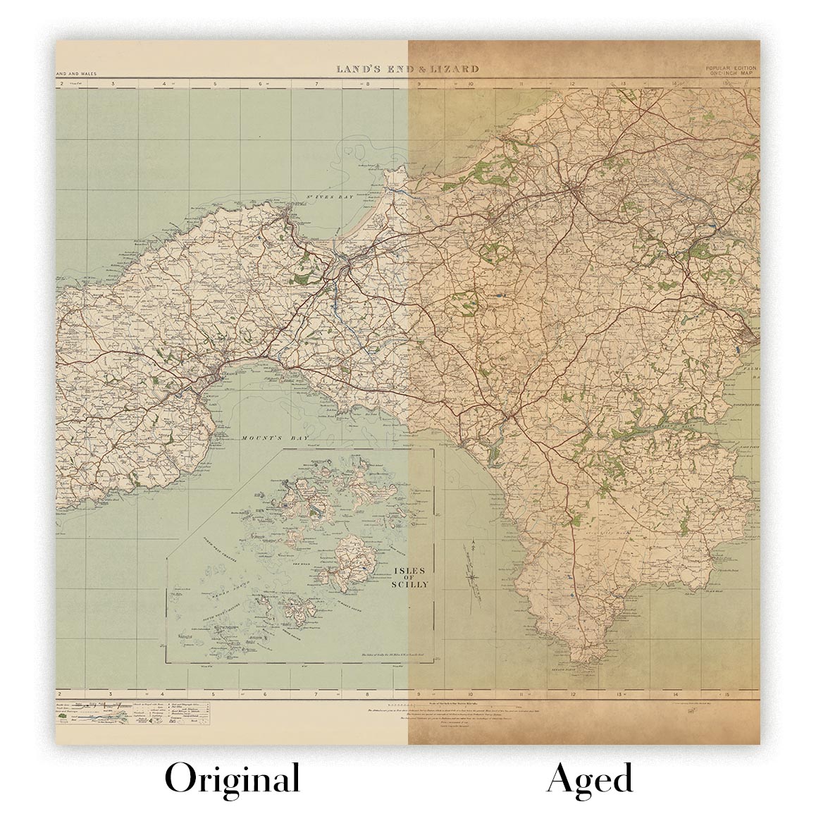
Envejecimiento del mapa
A lo largo de los años, los clientes me han preguntado cientos de veces si podían comprar un mapa que se viera uniforme. más viejo.
Bueno, ahora puedes hacerlo seleccionando Envejecido antes de agregar un mapa a tu carrito.
Todas las fotografías de productos que ve en esta página muestran el mapa en su forma original. Así es como se ve el mapa hoy.
Si selecciona Envejecido, envejeceré su mapa a mano, usando un proceso especial y único desarrollado a través de años de estudiar mapas antiguos, hablar con investigadores para comprender la química del envejecimiento del papel y, por supuesto... ¡mucha práctica!
Si no estás seguro, quédate con el color original del mapa. Si quieres algo un poco más oscuro y más viejo buscando, opte por Envejecido.
Si no estás satisfecho con tu pedido por cualquier motivo, contáctame para un reembolso sin complicaciones. Por favor, consulta nuestra política de devoluciones y reembolsos para más información.
Estoy muy seguro de que te gustará tu mapa o impresión artística restaurada. He estado haciendo esto desde 1984. Soy un vendedor de 5 estrellas en Etsy. He vendido decenas de miles de mapas e impresiones artísticas y tengo más de 5,000 opiniones reales de 5 estrellas.
Utilizo un proceso único para restaurar mapas y obras de arte que consume mucho tiempo y mano de obra. Buscar los mapas e ilustraciones originales puede llevar meses. Utilizo tecnología de última generación y extremadamente cara para escanear y restaurarlos. Como resultado, garantizo que mis mapas e impresiones artísticas son superiores a los demás - por eso puedo ofrecer un reembolso sin complicaciones.
Casi todos mis mapas e impresiones artísticas se ven increíbles en tamaños grandes (200cm, 6.5ft+) y también puedo enmarcarlos y entregártelos a través de un servicio de mensajería especial para tamaños grandes. Contáctame para discutir tus necesidades específicas.
Or try searching for something!


