


Mapa antiguo de Hautes-Alpes de Vuillemin, 1869: Gap, Briançon, Embrun, cumbres alpinas, escudos de armas
20% de descuento en 2 — 33% de descuento en 3
Añade dos artículos elegibles a tu carrito para recibir 20% de descuento. Añade un tercero y será complementario (equivalente a 33% de descuento al comprar tres).
No se necesita código — la oferta se aplica automáticamente al finalizar la compra.
Válido en todos los mapas estándar y impresiones de arte fino. Puedes mezclar y combinar cualquier diseño.
Si deseas enviar artículos a múltiples direcciones, por favor contáctanos antes de realizar tu pedido.
Las comisiones personalizadas y a medida están excluidas.
Contáctanos si tienes alguna pregunta
 Diseñado en Londres Hecho en Canada
Diseñado en Londres • Hecho en Canada
Diseñado en Londres Hecho en Canada
Diseñado en Londres • Hecho en Canada

Choose your size
Choose your finish


(Más información)
Mensaje de regalo y acabado personalizado

Si deseas agregar un mensaje de regalo, o un acabado (rompecabezas, tablero de aluminio, etc.) que no esté disponible aquí, por favor solicítalo en la "nota del pedido" cuando realices la compra.
Cada pedido es hecho a medida, así que si necesitas que el tamaño se ajuste ligeramente, o que se imprima en un material inusual, háznoslo saber. Hemos realizado miles de pedidos personalizados a lo largo de los años, así que hay (casi) nada que no podamos gestionar.
También puedes contactarnos antes de hacer tu pedido, ¡si lo prefieres!

- Made locally for fast, safe delivery
- No import duty or hidden fees
- Need advice? Message us on WhatsApp
Own a piece of history
7,000+ 5 star reviews


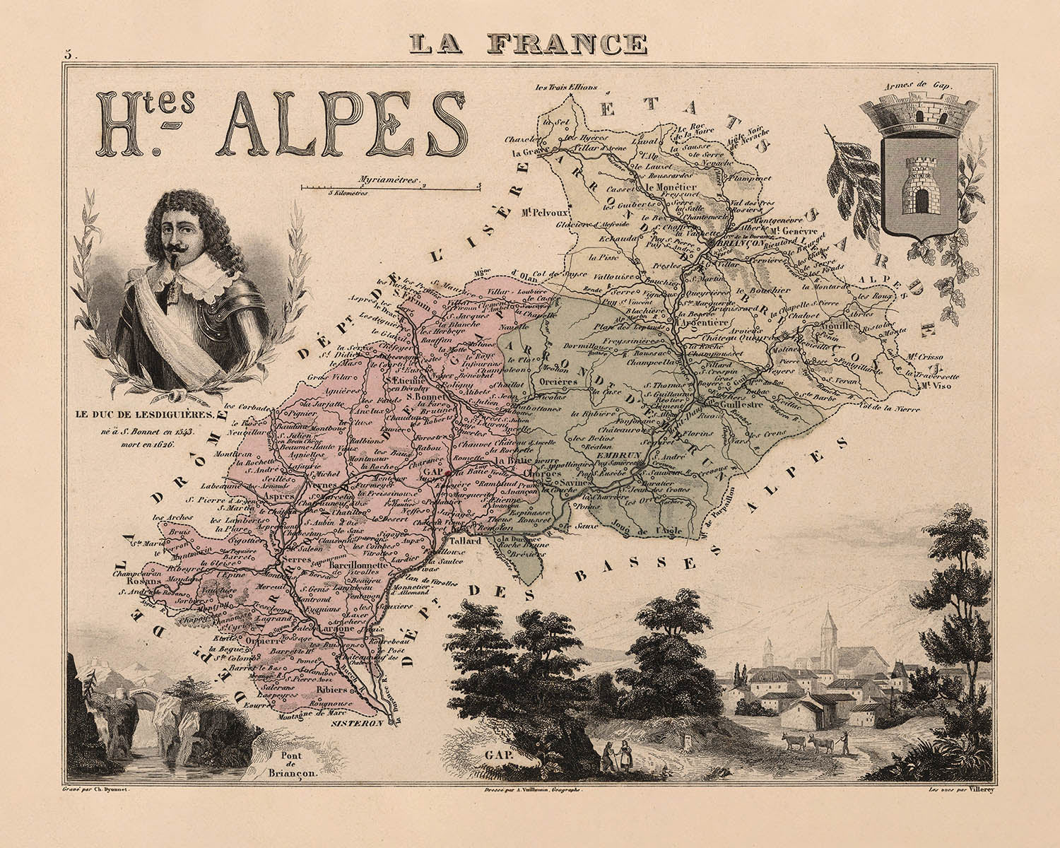
Adéntrese en los paisajes legendarios de la Francia del siglo XIX con “Hautes-Alpes”, una obra maestra cartográfica original de 1869 del prestigioso cartógrafo francés A. Vuillemin. Con su evocador título, este mapa captura la esencia del departamento de Hautes-Alpes, una región definida por sus imponentes cumbres alpinas, ríos sinuosos y asentamientos centenarios. La obra de Vuillemin es célebre por su meticulosa atención al detalle y su rica narración visual, convirtiendo este mapa no solo en una herramienta de orientación, sino también en una ventana a la cultura y la historia de un territorio francés singular.
A. Vuillemin era reconocido por su capacidad para combinar la precisión científica con un refinamiento artístico, y este mapa es testimonio de su legado. Cada límite y subdivisión están representados con claridad, mientras que los márgenes del mapa se adornan con vibrantes viñetas. Estas ilustraciones dan vida a las costumbres locales, la indumentaria tradicional y la abundancia agrícola de Hautes-Alpes, invitando al espectador a explorar tanto la geografía como el espíritu de la región. Los escudos decorativos y las figuras finamente dibujadas subrayan el orgullo y la identidad del departamento durante el Segundo Imperio francés.
El diseño del mapa combina a la perfección forma y función, con fronteras políticas y elementos naturales elegantemente entrelazados. El relieve montañoso domina la composición, capturando la dramática topografía que ha modelado tanto la historia como la vida cotidiana de Hautes-Alpes. Los ríos y cursos de agua, arterias vitales del comercio y el sustento, están claramente señalados, guiando la vista a través de valles y pastizales. Estos elementos geográficos no son meros telones de fondo, sino protagonistas centrales en la historia de la región, reflejando la relación perdurable entre las personas y el lugar.
La cartografía de Vuillemin va más allá del paisaje físico para celebrar la riqueza cultural de Hautes-Alpes. Las viñetas representan escenas de la vida rural, desde el cuidado de los cultivos hasta los ritmos pastoriles de la agricultura local. La inclusión de figuras históricas destacadas y de la fauna regional añade una dimensión adicional, ofreciendo un retrato matizado de una comunidad moldeada tanto por su entorno como por su herencia. Cada detalle, desde la vestimenta de los habitantes hasta los animales emblemáticos, está representado con una sensibilidad que habla del profundo aprecio del cartógrafo por la región.
Las ciudades y localidades destacadas —Gap, Briançon, Embrun y otras— se erigen como testigos perdurables de siglos de historia. Su ubicación en el mapa no solo facilita la orientación, sino que también ancla la narrativa de Hautes-Alpes, conectando al espectador con los ritmos de la vida cotidiana y el paso del tiempo. Este mapa es más que un documento histórico; es una celebración del lugar, del arte y del legado perdurable de uno de los cartógrafos más talentosos de Francia. Para el coleccionista exigente, “Hautes-Alpes” ofrece una rara oportunidad de poseer una pieza de historia cartográfica impregnada de belleza y significado.
Ciudades y localidades en este mapa
- Gap
- Briançon
- Embrun
- Veynes
- Guillestre
- Serres
- Chorges
- Laragne
Características destacadas y lugares de interés
- Límites departamentales y subdivisiones dentro de Hautes-Alpes claramente marcados
- Escudos decorativos que representan el departamento
- Ilustraciones que representan actividades agrícolas locales y cultivos
- Escenas que ilustran las costumbres locales y la vestimenta tradicional
- Representaciones del terreno montañoso, destacando la geografía alpina de la región
- Ríos y cursos de agua claramente señalados, destacando su importancia para la geografía y la economía locales
- Ilustraciones de animales locales representativos de la fauna de la región
- Figuras históricas o culturales notables asociadas con la región de los Hautes-Alpes
Contexto histórico y de diseño
- Creado en 1869 por A. Vuillemin, un reconocido cartógrafo francés del siglo XIX
- Mapa político detallado del departamento de Hautes-Alpes, en el sureste de Francia
- Presenta elementos decorativos, incluidos límites coloreados, escudos de armas y viñetas detalladas que ilustran la cultura local, la agricultura y figuras destacadas
- Acompañado de texto descriptivo en la publicación original, que proporciona datos estadísticos y contexto geográfico
- Refleja la organización administrativa, la identidad cultural y las actividades económicas de los Hautes-Alpes durante el Segundo Imperio Francés
Por favor, compruebe cuidadosamente las imágenes para asegurarse de que se muestra un pueblo o lugar específico en este mapa. También puede ponerse en contacto con nosotros y pedirnos que revisemos el mapa por usted.
Este mapa queda великолепно en cualquier tamaño, pero siempre recomiendo optar por un tamaño mayor si dispone de espacio. Así podrá apreciar fácilmente todos los detalles.
Este mapa luce increíble en tamaños de hasta 50in (125cm). Si busca un mapa más grande, por favor póngase en contacto.
La modelo de las imágenes del anuncio sostiene la versión de 16x20in (40x50cm) de este mapa.
La quinta imagen del anuncio muestra un ejemplo de mi servicio de personalización de mapas.
Si busca algo un poco diferente, eche un vistazo a mi colección de los mejores mapas antiguos para ver si algo más llama su atención.
Por favor contácteme para comprobar si una ubicación, punto de interés o elemento concreto aparece en este mapa.
Sería un regalo maravilloso de cumpleaños, Navidad, Día del Padre, despedida del trabajo, aniversario o inauguración de la casa para alguien de las zonas abarcadas por este mapa.
Este mapa está disponible como impresión giclée en papel mate de archivo sin ácido, o puede adquirirse enmarcado. El marco es un bonito y sencillo marco negro que se adapta a la mayoría de las estéticas. Por favor, póngase en contacto si desea un color o material de marco diferente. Mis marcos están acristalados con acrílico de calidad museo de gran transparencia (perspex/acrylite), que es significativamente menos reflectante que el vidrio, más seguro y siempre llegará en perfectas condiciones.
This map is also available as a float framed canvas, sometimes known as a shadow gap framed canvas or canvas floater. The map is printed on artist's cotton canvas and then stretched over a handmade box frame. We then "float" the canvas inside a wooden frame, which is available in a range of colours (black, dark brown, oak, antique gold and white). This is a wonderful way to present a map without glazing in front. See some examples of float framed canvas maps and explore the differences between my different finishes.
For something truly unique, this map is also available in "Unique 3D", our trademarked process that dramatically transforms the map so that it has a wonderful sense of depth. We combine the original map with detailed topography and elevation data, so that mountains and the terrain really "pop". For more info and examples of 3D maps, check my Unique 3D page.
Many of our maps and art prints are chosen as thoughtful gifts for homes, offices, studies and meaningful places.
Choose a framed option for the easiest ready-to-hang gift, or choose an unframed print if the recipient may prefer to select their own frame.
We make orders locally in 23 countries around the world, so gifts can often be produced close to the recipient. This helps them arrive faster, travel more safely, and avoid customs or import duty surprises.
- We can deliver directly to the recipient
- Framed pieces arrive ready to hang
- Unframed prints are carefully packed in a strong protective tube
- Almost every order is made locally, for faster, safer gifting
- 90-day returns give the recipient time to decide
If you are not sure what to choose, please contact us. We can help you pick the right map, size, finish or delivery option.
Para la mayoría de los pedidos, el tiempo de entrega es de aproximadamente 3 días laborables. Los productos personalizados y a medida tardan más, ya que tengo que hacer la personalización y enviártelo para su aprobación, lo cual suele tardar 1 o 2 días.
Tenga en cuenta que los pedidos enmarcados muy grandes suelen tardar más en fabricarse y entregarse.
Si necesitas que tu pedido llegue para una fecha determinada, por favor contáctame antes de hacer el pedido para que podamos encontrar la mejor manera de asegurarnos de que recibas tu pedido a tiempo.
Imprimo y enmarco mapas y obras de arte en 23 países alrededor del mundo. Esto significa que tu pedido se fabricará localmente, lo que reduce el tiempo de entrega y asegura que no se dañe durante el envío. Nunca pagarás aranceles de aduana o impuestos de importación, y pondremos menos CO2 en el aire.
Todos mis mapas y impresiones artísticas están bien empaquetados y enviados en un tubo resistente si no están enmarcados, o rodeados de espuma si están enmarcados.
Intento enviar todos los pedidos dentro de 1 o 2 días después de recibir tu pedido, aunque algunos productos (como mascarillas, tazas y bolsas de tela) pueden tardar más en fabricarse.
Si seleccionas Entrega Exprés al finalizar la compra, priorizaremos tu pedido y lo enviaremos por mensajería de 1 día (Fedex, DHL, UPS, Parcelforce).
La entrega al día siguiente también está disponible en algunos países (EE. UU., Reino Unido, Singapur, EAU), pero por favor intenta hacer tu pedido temprano en el día para que podamos enviarlo a tiempo.
Mi marco estándar es un marco de madera de fresno negro estilo galería. Es simple y tiene un aspecto bastante moderno. Mi marco estándar tiene alrededor de 20 mm (0.8 in) de ancho.
Utilizo acrílico super claro (perspex/acrylite) para el vidrio del marco. Es más ligero y seguro que el vidrio, y se ve mejor, ya que la reflectividad es menor.
Seis colores de marco estándar están disponibles de forma gratuita (negro, marrón oscuro, gris oscuro, roble, blanco y oro antiguo).El enmarcado y montaje/matizado personalizado está disponible si buscas algo diferente.
La mayoría de los mapas, arte e ilustraciones también están disponibles como un lienzo enmarcado. Utilizamos lienzo de algodón mate (no brillante), lo estiramos sobre un marco de madera de caja de origen sostenible, y luego 'flotamos' la pieza dentro de un marco de madera. El resultado final es bastante hermoso, y no hay cristal que se interponga.
Todos los marcos se proporcionan "listos para colgar", con una cuerda o soportes en la parte posterior. Los marcos muy grandes tendrán placas de colgar de alta resistencia y/o un listón de montaje. Si tienes alguna pregunta, por favor ponte en contacto.
Mira algunos ejemplos de mis mapas enmarcados y mapas en lienzo enmarcados.
Alternativamente, también puedo proporcionar mapas antiguos y obras de arte en lienzo, tablero de espuma, papel de algodón y otros materiales.
Si deseas enmarcar tu mapa o obra de arte tú mismo, por favor lee mi guía de tamaños primero.
Mis mapas son reproducciones de mapas originales de altísima calidad.
Obtengo mapas originales y raros de bibliotecas, casas de subastas y colecciones privadas de todo el mundo, los restauro en mi taller de Londres y luego uso tintas e impresoras giclée especializadas para crear hermosos mapas que lucen incluso mejor que el original.
Mis mapas están impresos en papel de archivo mate (no brillante) sin ácido que se siente de muy alta calidad y casi como una tarjeta. En términos técnicos, el peso/grosor del papel es de 10 mil/200 g/m². Es perfecto para enmarcar.
Imprimo con tintas pigmentadas Epson ultrachrome giclée UV resistentes a la decoloración, algunas de las mejores tintas que puedes encontrar.
yo también puedo hacer mapas sobre lienzo, trapo de algodón y otros materiales exóticos.
Obtenga más información sobre The Unique Maps Co..
Personalización de mapas
Si está buscando el regalo perfecto de aniversario o inauguración de la casa, puedo personalizar su mapa para hacerlo verdaderamente único. Por ejemplo, puedo agregar un mensaje corto, resaltar una ubicación importante o agregar el escudo de armas de su familia.
Las opciones son casi infinitas. Por favor mira mi página de personalización de mapas para ver algunos maravillosos ejemplos de lo que es posible.
Para pedir un mapa personalizado, seleccione "personalizar su mapa" antes de agregarlo a su carrito.
Ponerse en contacto si buscas personalizaciones y personalizaciones más complejas.
Envejecimiento del mapa
A lo largo de los años, los clientes me han preguntado cientos de veces si podían comprar un mapa que se viera uniforme. más viejo.
Bueno, ahora puedes hacerlo seleccionando Envejecido antes de agregar un mapa a tu carrito.
Todas las fotografías de productos que ve en esta página muestran el mapa en su forma original. Así es como se ve el mapa hoy.
Si selecciona Envejecido, envejeceré su mapa a mano, usando un proceso especial y único desarrollado a través de años de estudiar mapas antiguos, hablar con investigadores para comprender la química del envejecimiento del papel y, por supuesto... ¡mucha práctica!
Si no estás seguro, quédate con el color original del mapa. Si quieres algo un poco más oscuro y más viejo buscando, opte por Envejecido.
Si no estás satisfecho con tu pedido por cualquier motivo, contáctame para un reembolso sin complicaciones. Por favor, consulta nuestra política de devoluciones y reembolsos para más información.
Estoy muy seguro de que te gustará tu mapa o impresión artística restaurada. He estado haciendo esto desde 1984. Soy un vendedor de 5 estrellas en Etsy. He vendido decenas de miles de mapas e impresiones artísticas y tengo más de 5,000 opiniones reales de 5 estrellas.
Utilizo un proceso único para restaurar mapas y obras de arte que consume mucho tiempo y mano de obra. Buscar los mapas e ilustraciones originales puede llevar meses. Utilizo tecnología de última generación y extremadamente cara para escanear y restaurarlos. Como resultado, garantizo que mis mapas e impresiones artísticas son superiores a los demás - por eso puedo ofrecer un reembolso sin complicaciones.
Casi todos mis mapas e impresiones artísticas se ven increíbles en tamaños grandes (200cm, 6.5ft+) y también puedo enmarcarlos y entregártelos a través de un servicio de mensajería especial para tamaños grandes. Contáctame para discutir tus necesidades específicas.
Or try searching for something!


