


Mapa antiguo de Irán de Tallis, 1851: Persia, Teherán, Isfahán, mar Caspio, montes Elburz y Zagros
20% de descuento en 2 — 33% de descuento en 3
Añade dos artículos elegibles a tu carrito para recibir 20% de descuento. Añade un tercero y será complementario (equivalente a 33% de descuento al comprar tres).
No se necesita código — la oferta se aplica automáticamente al finalizar la compra.
Válido en todos los mapas estándar y impresiones de arte fino. Puedes mezclar y combinar cualquier diseño.
Si deseas enviar artículos a múltiples direcciones, por favor contáctanos antes de realizar tu pedido.
Las comisiones personalizadas y a medida están excluidas.
Contáctanos si tienes alguna pregunta
 Diseñado en Londres Hecho en Canada
Diseñado en Londres • Hecho en Canada
Diseñado en Londres Hecho en Canada
Diseñado en Londres • Hecho en Canada

Restaurado a partir del mapa original de 1851 e impreso en calidad museo. Leer la historia detrás de este mapa
Choose your size
Choose your finish


(Más información)
Mensaje de regalo y acabado personalizado

Si deseas agregar un mensaje de regalo, o un acabado (rompecabezas, tablero de aluminio, etc.) que no esté disponible aquí, por favor solicítalo en la "nota del pedido" cuando realices la compra.
Cada pedido es hecho a medida, así que si necesitas que el tamaño se ajuste ligeramente, o que se imprima en un material inusual, háznoslo saber. Hemos realizado miles de pedidos personalizados a lo largo de los años, así que hay (casi) nada que no podamos gestionar.
También puedes contactarnos antes de hacer tu pedido, ¡si lo prefieres!

- Hecho localmente. Entrega segura
- Sin aranceles ni cargos ocultos
- ¿Necesitas ayuda? Llámanos o mensaje por WhatsApp
Own a piece of history
8,000+ five-star reviews


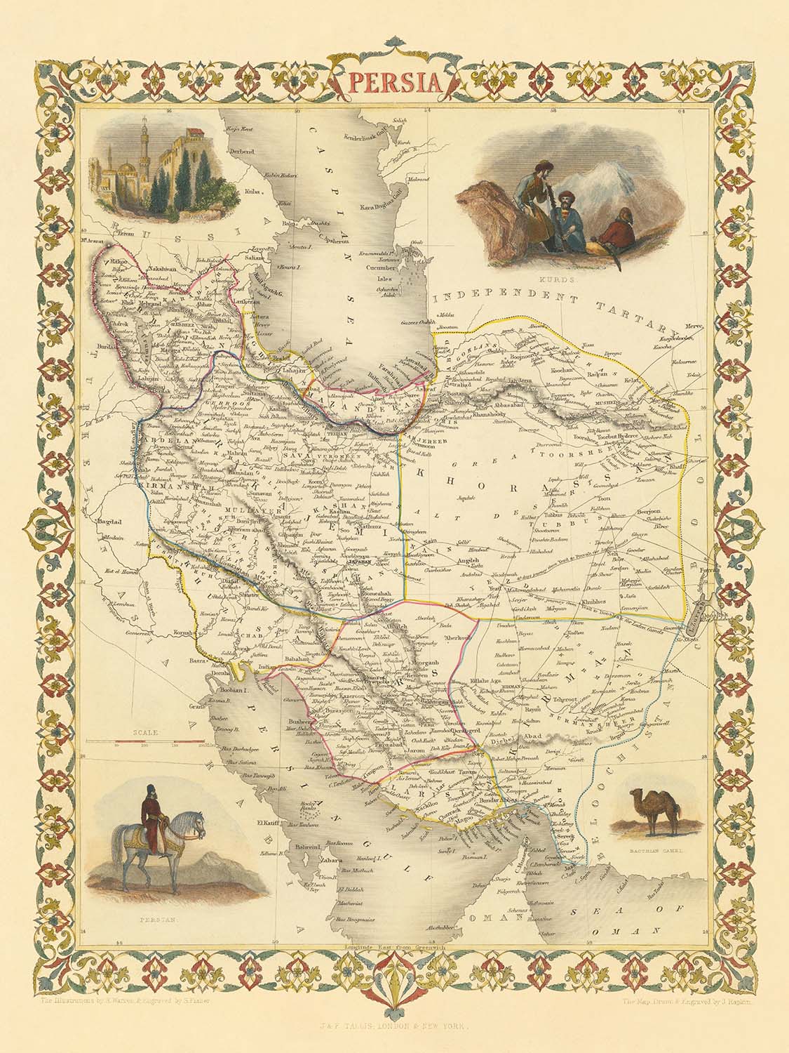
Adéntrese en el rico tapiz de la cartografía del siglo XIX con “Persia”, un exquisito mapa grabado por el renombrado John Tallis...
Seguir leyendoAdéntrese en el rico tapiz de la cartografía del siglo XIX con “Persia”, un exquisito mapa grabado por el renombrado John Tallis en 1851. Esta obra original, realizada para el célebre Illustrated Atlas de R. Montgomery Martin, se erige como testimonio del arte y la precisión de uno de los últimos grandes creadores de mapas decorativos. Los mapas de Tallis son muy apreciados por sus cautivadoras viñetas y su meticulosa atención al detalle, y “Persia” no es la excepción: ofrece una vívida ventana al corazón de una región impregnada de historia, cultura y grandeza natural.
El mapa despliega la vasta extensión de la Persia histórica, un territorio que hoy comprende el Irán moderno y se adentra en el vecino Afganistán, Baluchistán y las tierras que lindan con el mar Caspio y el golfo Pérsico. Los límites están elegantemente delineados, revelando el panorama político de la época, mientras que la intrincada representación de las cordilleras del Elburz y de los Zagros evoca las formidables barreras naturales que han moldeado la civilización persa durante milenios. La cuidadosa representación de desiertos, como el Gran Desierto Salado y el desierto de Lut, destaca los dramáticos contrastes que definen esta célebre tierra.
Un sello distintivo del arte de Tallis es la inclusión de viñetas evocadoras, y “Persia” deleita con sus ilustraciones decorativas. Estas incluyen una vista panorámica de Ispahan (la actual Isfahán), la resplandeciente ciudad que en otro tiempo fue capital del Imperio safávida; un grupo de kurdos con atuendo tradicional, reflejo de la diversidad étnica de la región; un solemne camello bactriano, emblema de las caravanas de la Ruta de la Seda; y un jinete persa, que captura las tradiciones ecuestres profundamente entretejidas en la identidad persa. Estas escenas ofrecen una rara mirada a la vida cotidiana y al dinamismo cultural de la Persia del siglo XIX.
La amplitud geográfica del mapa abarca una constelación de ciudades y poblaciones que siguen siendo vitales para el mundo moderno, entre ellas Teherán, Tabriz, Mashhad, Shiraz y Yazd. Cada asentamiento está elegantemente inscrito, dando testimonio de siglos de historia, comercio y logros artísticos. Las ciudades costeras de Bushehr y Bandar Abbas anclan las conexiones marítimas de Persia, mientras que los antiguos centros de Herat y Kandahar, hoy en Afganistán, evocan la perdurable importancia de la región como encrucijada de imperios.
“Persia” de John Tallis es más que un mapa: es una obra maestra de narración histórica, que combina precisión científica con elegancia decorativa. Los exuberantes bordes del mapa, sus intrincados grabados y sus viñetas culturales invitan al espectador a viajar a través del tiempo, siguiendo las fronteras cambiantes, las maravillas naturales y las sociedades vibrantes que han definido el lugar de Persia en el mundo. Para coleccionistas y conocedores del arte cartográfico, este mapa ofrece una oportunidad excepcional de poseer un fragmento de historia, capturando el espíritu y el esplendor de una tierra en la encrucijada entre Oriente y Occidente.
Ciudades y poblaciones en este mapa
- Irán (actual):
- Teherán
- Isfahán (Ispahan)
- Tabriz
- Mashhad (Meshed)
- Shiraz
- Yazd (Yezd)
- Kerman (Kirman)
- Qazvin (Kazvin)
- Kashan
- Bushehr (Bushire)
- Hamadan (Hamadan)
- Bandar Abbas (Gombroon)
- Rasht (Resht)
-
Ardabil (Ardebil)
-
Afganistán (actual):
- Herat
-
Kandahar (Candahar)
-
Pakistán (actual):
- Gwadar (Guadel)
Características destacadas & lugares de interés
- Vista de Ispahán (Esfahan) (viñeta decorativa)
- Representación de kurdos con atuendo tradicional (viñeta decorativa)
- Ilustración de un camello bactriano (viñeta decorativa)
- Figura persa a caballo (viñeta decorativa)
- Golfo Pérsico
- Mar Caspio
- Golfo de Omán
- Montes Elburz (Alborz)
- Montes Zagros
- Gran Desierto Salado (Dasht-e Kavir)
- Desierto de Lut (Dasht-e Lut)
- Fronteras de la Persia histórica claramente delineadas
- Regiones vecinas señaladas, incluidas Afganistán, Baluchistán y partes de Turkestán
Contexto histórico y de diseño
- Creado por John Tallis en 1851, uno de los últimos grandes cartógrafos decorativos del siglo XIX
- Producido para el Illustrated Atlas de R. Montgomery Martin
- Destaca por sus bordes decorativos, su grabado detallado y la inclusión de viñetas artísticas que representan escenas, personas y animales autóctonos
- Ofrece una vívida instantánea de la geografía política y física de Persia a mediados del siglo XIX
- Muy apreciado por los coleccionistas por su combinación de precisión cartográfica y elegancia artística
- Refleja los límites geopolíticos, las percepciones culturales y las tradiciones cartográficas europeas de su época
Please double check the images to make sure that a specific town or place is shown on this map. You can also get in touch and ask us to check the map for you.
Este mapa luce estupendo en cualquier tamaño, pero siempre recomiendo optar por un tamaño mayor si dispone de espacio. Así podrá distinguir fácilmente todos los detalles.
Este mapa se ve increíble en tamaños de hasta 50in (125cm). Si busca un mapa más grande, por favor póngase en contacto.
El modelo en las imágenes del anuncio sostiene la versión de 18x24in (45x60cm) de este mapa.
La quinta imagen del anuncio muestra un ejemplo de mi servicio de personalización de mapas.
Si busca algo ligeramente diferente, eche un vistazo a mi colección de los mejores mapas antiguos para ver si algo más llama su atención.
Por favor, contácteme para comprobar si una determinada ubicación, lugar de interés o elemento aparece en este mapa.
Esto sería un maravilloso regalo de cumpleaños, Navidad, Día del Padre, despedida de trabajo, aniversario o inauguración de casa para alguien de las zonas cubiertas por este mapa.
Este mapa está disponible como impresión giclée en papel mate de archivo libre de ácido, o puede comprarlo enmarcado. El marco es un bonito y sencillo marco negro que se adapta a la mayoría de las estéticas. Por favor, póngase en contacto si desea un color o material de marco diferente. Mis marcos están acristalados con acrílico de calidad museística supertransparente (perspex/acrylite), que es considerablemente menos reflectante que el vidrio, más seguro y llegará siempre en perfecto estado.
This map is also available as a float framed canvas, sometimes known as a shadow gap framed canvas or canvas floater. The map is printed on artist's cotton canvas and then stretched over a handmade box frame. We then "float" the canvas inside a wooden frame, which is available in a range of colours (black, dark brown, oak, antique gold and white). This is a wonderful way to present a map without glazing in front. See some examples of float framed canvas maps and explore the differences between my different finishes.
For something truly unique, this map is also available in "Unique 3D", our trademarked process that dramatically transforms the map so that it has a wonderful sense of depth. We combine the original map with detailed topography and elevation data, so that mountains and the terrain really "pop". For more info and examples of 3D maps, check my Unique 3D page.
Adéntrese en el rico tapiz de la cartografía del siglo XIX con “Persia”, un exquisito mapa grabado por el renombrado John Tallis en 1851. Esta obra original, realizada para el célebre Illustrated Atlas de R. Montgomery Martin, se erige como testimonio del arte y la precisión de uno de los últimos grandes creadores de mapas decorativos. Los mapas de Tallis son muy apreciados por sus cautivadoras viñetas y su meticulosa atención al detalle, y “Persia” no es la excepción: ofrece una vívida ventana al corazón de una región impregnada de historia, cultura y grandeza natural.
El mapa despliega la vasta extensión de la Persia histórica, un territorio que hoy comprende el Irán moderno y se adentra en el vecino Afganistán, Baluchistán y las tierras que lindan con el mar Caspio y el golfo Pérsico. Los límites están elegantemente delineados, revelando el panorama político de la época, mientras que la intrincada representación de las cordilleras del Elburz y de los Zagros evoca las formidables barreras naturales que han moldeado la civilización persa durante milenios. La cuidadosa representación de desiertos, como el Gran Desierto Salado y el desierto de Lut, destaca los dramáticos contrastes que definen esta célebre tierra.
Un sello distintivo del arte de Tallis es la inclusión de viñetas evocadoras, y “Persia” deleita con sus ilustraciones decorativas. Estas incluyen una vista panorámica de Ispahan (la actual Isfahán), la resplandeciente ciudad que en otro tiempo fue capital del Imperio safávida; un grupo de kurdos con atuendo tradicional, reflejo de la diversidad étnica de la región; un solemne camello bactriano, emblema de las caravanas de la Ruta de la Seda; y un jinete persa, que captura las tradiciones ecuestres profundamente entretejidas en la identidad persa. Estas escenas ofrecen una rara mirada a la vida cotidiana y al dinamismo cultural de la Persia del siglo XIX.
La amplitud geográfica del mapa abarca una constelación de ciudades y poblaciones que siguen siendo vitales para el mundo moderno, entre ellas Teherán, Tabriz, Mashhad, Shiraz y Yazd. Cada asentamiento está elegantemente inscrito, dando testimonio de siglos de historia, comercio y logros artísticos. Las ciudades costeras de Bushehr y Bandar Abbas anclan las conexiones marítimas de Persia, mientras que los antiguos centros de Herat y Kandahar, hoy en Afganistán, evocan la perdurable importancia de la región como encrucijada de imperios.
“Persia” de John Tallis es más que un mapa: es una obra maestra de narración histórica, que combina precisión científica con elegancia decorativa. Los exuberantes bordes del mapa, sus intrincados grabados y sus viñetas culturales invitan al espectador a viajar a través del tiempo, siguiendo las fronteras cambiantes, las maravillas naturales y las sociedades vibrantes que han definido el lugar de Persia en el mundo. Para coleccionistas y conocedores del arte cartográfico, este mapa ofrece una oportunidad excepcional de poseer un fragmento de historia, capturando el espíritu y el esplendor de una tierra en la encrucijada entre Oriente y Occidente.
Ciudades y poblaciones en este mapa
- Irán (actual):
- Teherán
- Isfahán (Ispahan)
- Tabriz
- Mashhad (Meshed)
- Shiraz
- Yazd (Yezd)
- Kerman (Kirman)
- Qazvin (Kazvin)
- Kashan
- Bushehr (Bushire)
- Hamadan (Hamadan)
- Bandar Abbas (Gombroon)
- Rasht (Resht)
-
Ardabil (Ardebil)
-
Afganistán (actual):
- Herat
-
Kandahar (Candahar)
-
Pakistán (actual):
- Gwadar (Guadel)
Características destacadas & lugares de interés
- Vista de Ispahán (Esfahan) (viñeta decorativa)
- Representación de kurdos con atuendo tradicional (viñeta decorativa)
- Ilustración de un camello bactriano (viñeta decorativa)
- Figura persa a caballo (viñeta decorativa)
- Golfo Pérsico
- Mar Caspio
- Golfo de Omán
- Montes Elburz (Alborz)
- Montes Zagros
- Gran Desierto Salado (Dasht-e Kavir)
- Desierto de Lut (Dasht-e Lut)
- Fronteras de la Persia histórica claramente delineadas
- Regiones vecinas señaladas, incluidas Afganistán, Baluchistán y partes de Turkestán
Contexto histórico y de diseño
- Creado por John Tallis en 1851, uno de los últimos grandes cartógrafos decorativos del siglo XIX
- Producido para el Illustrated Atlas de R. Montgomery Martin
- Destaca por sus bordes decorativos, su grabado detallado y la inclusión de viñetas artísticas que representan escenas, personas y animales autóctonos
- Ofrece una vívida instantánea de la geografía política y física de Persia a mediados del siglo XIX
- Muy apreciado por los coleccionistas por su combinación de precisión cartográfica y elegancia artística
- Refleja los límites geopolíticos, las percepciones culturales y las tradiciones cartográficas europeas de su época
Please double check the images to make sure that a specific town or place is shown on this map. You can also get in touch and ask us to check the map for you.
Este mapa luce estupendo en cualquier tamaño, pero siempre recomiendo optar por un tamaño mayor si dispone de espacio. Así podrá distinguir fácilmente todos los detalles.
Este mapa se ve increíble en tamaños de hasta 50in (125cm). Si busca un mapa más grande, por favor póngase en contacto.
El modelo en las imágenes del anuncio sostiene la versión de 18x24in (45x60cm) de este mapa.
La quinta imagen del anuncio muestra un ejemplo de mi servicio de personalización de mapas.
Si busca algo ligeramente diferente, eche un vistazo a mi colección de los mejores mapas antiguos para ver si algo más llama su atención.
Por favor, contácteme para comprobar si una determinada ubicación, lugar de interés o elemento aparece en este mapa.
Esto sería un maravilloso regalo de cumpleaños, Navidad, Día del Padre, despedida de trabajo, aniversario o inauguración de casa para alguien de las zonas cubiertas por este mapa.
Este mapa está disponible como impresión giclée en papel mate de archivo libre de ácido, o puede comprarlo enmarcado. El marco es un bonito y sencillo marco negro que se adapta a la mayoría de las estéticas. Por favor, póngase en contacto si desea un color o material de marco diferente. Mis marcos están acristalados con acrílico de calidad museística supertransparente (perspex/acrylite), que es considerablemente menos reflectante que el vidrio, más seguro y llegará siempre en perfecto estado.
This map is also available as a float framed canvas, sometimes known as a shadow gap framed canvas or canvas floater. The map is printed on artist's cotton canvas and then stretched over a handmade box frame. We then "float" the canvas inside a wooden frame, which is available in a range of colours (black, dark brown, oak, antique gold and white). This is a wonderful way to present a map without glazing in front. See some examples of float framed canvas maps and explore the differences between my different finishes.
For something truly unique, this map is also available in "Unique 3D", our trademarked process that dramatically transforms the map so that it has a wonderful sense of depth. We combine the original map with detailed topography and elevation data, so that mountains and the terrain really "pop". For more info and examples of 3D maps, check my Unique 3D page.
Many of our maps and art prints are chosen as thoughtful gifts for homes, offices, studies and meaningful places.
Choose a framed option for the easiest ready-to-hang gift, or choose an unframed print if the recipient may prefer to select their own frame.
We make orders locally in 23 countries around the world, so gifts can often be produced close to the recipient. This helps them arrive faster, travel more safely, and avoid customs or import duty surprises.
- We can deliver directly to the recipient
- Framed pieces arrive ready to hang
- Unframed prints are carefully packed in a strong protective tube
- Almost every order is made locally, for faster, safer gifting
- 90-day returns give the recipient time to decide
If you are not sure what to choose, please contact us. We can help you pick the right map, size, finish or delivery option.
Para la mayoría de los pedidos, el tiempo de entrega es de aproximadamente 3 días laborables. Los productos personalizados y a medida tardan más, ya que tengo que hacer la personalización y enviártelo para su aprobación, lo cual suele tardar 1 o 2 días.
Tenga en cuenta que los pedidos enmarcados muy grandes suelen tardar más en fabricarse y entregarse.
Si necesitas que tu pedido llegue para una fecha determinada, por favor contáctame antes de hacer el pedido para que podamos encontrar la mejor manera de asegurarnos de que recibas tu pedido a tiempo.
Imprimo y enmarco mapas y obras de arte en 23 países alrededor del mundo. Esto significa que tu pedido se fabricará localmente, lo que reduce el tiempo de entrega y asegura que no se dañe durante el envío. Nunca pagarás aranceles de aduana o impuestos de importación, y pondremos menos CO2 en el aire.
Todos mis mapas y impresiones artísticas están bien empaquetados y enviados en un tubo resistente si no están enmarcados, o rodeados de espuma si están enmarcados.
Intento enviar todos los pedidos dentro de 1 o 2 días después de recibir tu pedido, aunque algunos productos (como mascarillas, tazas y bolsas de tela) pueden tardar más en fabricarse.
Si seleccionas Entrega Exprés al finalizar la compra, priorizaremos tu pedido y lo enviaremos por mensajería de 1 día (Fedex, DHL, UPS, Parcelforce).
La entrega al día siguiente también está disponible en algunos países (EE. UU., Reino Unido, Singapur, EAU), pero por favor intenta hacer tu pedido temprano en el día para que podamos enviarlo a tiempo.
Mi marco estándar es un marco de madera de fresno negro estilo galería. Es simple y tiene un aspecto bastante moderno. Mi marco estándar tiene alrededor de 20 mm (0.8 in) de ancho.
Utilizo acrílico super claro (perspex/acrylite) para el vidrio del marco. Es más ligero y seguro que el vidrio, y se ve mejor, ya que la reflectividad es menor.
Seis colores de marco estándar están disponibles de forma gratuita (negro, marrón oscuro, gris oscuro, roble, blanco y oro antiguo).El enmarcado y montaje/matizado personalizado está disponible si buscas algo diferente.
La mayoría de los mapas, arte e ilustraciones también están disponibles como un lienzo enmarcado. Utilizamos lienzo de algodón mate (no brillante), lo estiramos sobre un marco de madera de caja de origen sostenible, y luego 'flotamos' la pieza dentro de un marco de madera. El resultado final es bastante hermoso, y no hay cristal que se interponga.
Todos los marcos se proporcionan "listos para colgar", con una cuerda o soportes en la parte posterior. Los marcos muy grandes tendrán placas de colgar de alta resistencia y/o un listón de montaje. Si tienes alguna pregunta, por favor ponte en contacto.
Mira algunos ejemplos de mis mapas enmarcados y mapas en lienzo enmarcados.
Alternativamente, también puedo proporcionar mapas antiguos y obras de arte en lienzo, tablero de espuma, papel de algodón y otros materiales.
Si deseas enmarcar tu mapa o obra de arte tú mismo, por favor lee mi guía de tamaños primero.
Mis mapas son reproducciones de mapas originales de altísima calidad.
Obtengo mapas originales y raros de bibliotecas, casas de subastas y colecciones privadas de todo el mundo, los restauro en mi taller de Londres y luego uso tintas e impresoras giclée especializadas para crear hermosos mapas que lucen incluso mejor que el original.
Mis mapas están impresos en papel de archivo mate (no brillante) sin ácido que se siente de muy alta calidad y casi como una tarjeta. En términos técnicos, el peso/grosor del papel es de 10 mil/200 g/m². Es perfecto para enmarcar.
Imprimo con tintas pigmentadas Epson ultrachrome giclée UV resistentes a la decoloración, algunas de las mejores tintas que puedes encontrar.
yo también puedo hacer mapas sobre lienzo, trapo de algodón y otros materiales exóticos.
Obtenga más información sobre The Unique Maps Co..
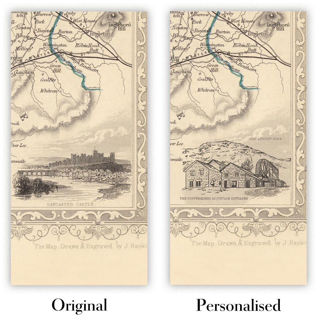
Personalización de mapas
Si está buscando el regalo perfecto de aniversario o inauguración de la casa, puedo personalizar su mapa para hacerlo verdaderamente único. Por ejemplo, puedo agregar un mensaje corto, resaltar una ubicación importante o agregar el escudo de armas de su familia.
Las opciones son casi infinitas. Por favor mira mi página de personalización de mapas para ver algunos maravillosos ejemplos de lo que es posible.
Para pedir un mapa personalizado, seleccione "personalizar su mapa" antes de agregarlo a su carrito.
Ponerse en contacto si buscas personalizaciones y personalizaciones más complejas.
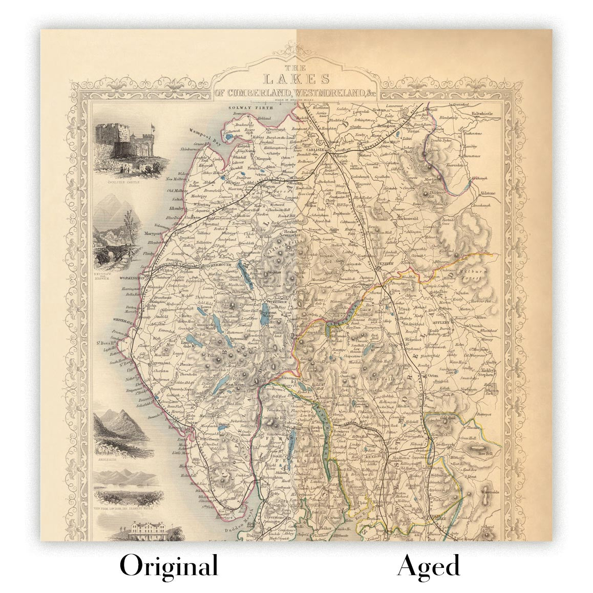
Envejecimiento del mapa
A lo largo de los años, los clientes me han preguntado cientos de veces si podían comprar un mapa que se viera uniforme. más viejo.
Bueno, ahora puedes hacerlo seleccionando Envejecido antes de agregar un mapa a tu carrito.
Todas las fotografías de productos que ve en esta página muestran el mapa en su forma original. Así es como se ve el mapa hoy.
Si selecciona Envejecido, envejeceré su mapa a mano, usando un proceso especial y único desarrollado a través de años de estudiar mapas antiguos, hablar con investigadores para comprender la química del envejecimiento del papel y, por supuesto... ¡mucha práctica!
Si no estás seguro, quédate con el color original del mapa. Si quieres algo un poco más oscuro y más viejo buscando, opte por Envejecido.
Si no estás satisfecho con tu pedido por cualquier motivo, contáctame para un reembolso sin complicaciones. Por favor, consulta nuestra política de devoluciones y reembolsos para más información.
Estoy muy seguro de que te gustará tu mapa o impresión artística restaurada. He estado haciendo esto desde 1984. Soy un vendedor de 5 estrellas en Etsy. He vendido decenas de miles de mapas e impresiones artísticas y tengo más de 5,000 opiniones reales de 5 estrellas.
Utilizo un proceso único para restaurar mapas y obras de arte que consume mucho tiempo y mano de obra. Buscar los mapas e ilustraciones originales puede llevar meses. Utilizo tecnología de última generación y extremadamente cara para escanear y restaurarlos. Como resultado, garantizo que mis mapas e impresiones artísticas son superiores a los demás - por eso puedo ofrecer un reembolso sin complicaciones.
Casi todos mis mapas e impresiones artísticas se ven increíbles en tamaños grandes (200cm, 6.5ft+) y también puedo enmarcarlos y entregártelos a través de un servicio de mensajería especial para tamaños grandes. Contáctame para discutir tus necesidades específicas.
Or try searching for something!


