


Antiguo mapa de la París medieval de Vuillemin, 1869: Notre-Dame, Île de la Cité, Sena, Louvre, murallas de la ciudad
20% de descuento en 2 — 33% de descuento en 3
Añade dos artículos elegibles a tu carrito para recibir 20% de descuento. Añade un tercero y será complementario (equivalente a 33% de descuento al comprar tres).
No se necesita código — la oferta se aplica automáticamente al finalizar la compra.
Válido en todos los mapas estándar y impresiones de arte fino. Puedes mezclar y combinar cualquier diseño.
Si deseas enviar artículos a múltiples direcciones, por favor contáctanos antes de realizar tu pedido.
Las comisiones personalizadas y a medida están excluidas.
Contáctanos si tienes alguna pregunta
 Designed in London Made in Canada
Designed in London • Made in Canada
Designed in London Made in Canada
Designed in London • Made in Canada

Choose your size
Choose your finish


(Más información)
Mensaje de regalo y acabado personalizado

Si deseas agregar un mensaje de regalo, o un acabado (rompecabezas, tablero de aluminio, etc.) que no esté disponible aquí, por favor solicítalo en la "nota del pedido" cuando realices la compra.
Cada pedido es hecho a medida, así que si necesitas que el tamaño se ajuste ligeramente, o que se imprima en un material inusual, háznoslo saber. Hemos realizado miles de pedidos personalizados a lo largo de los años, así que hay (casi) nada que no podamos gestionar.
También puedes contactarnos antes de hacer tu pedido, ¡si lo prefieres!

- Made locally for fast, safe delivery
- No import duty or hidden fees
- Need advice? Message us on WhatsApp
Own a piece of history
7,000+ 5 star reviews


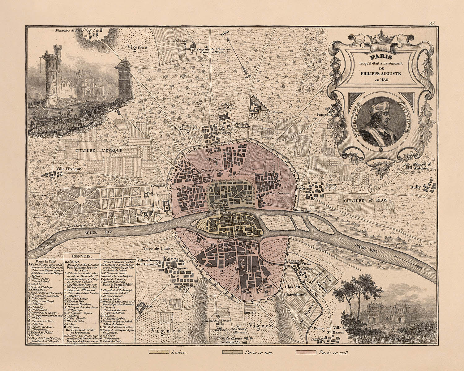
Retroceda en el tiempo hasta el corazón de la Europa medieval con "Paris in 1180", un magistral mapa histórico creado por A. Vuillemin en 1869. Este exquisito mapa urbano de la ciudad captura la capital francesa en un momento decisivo de su evolución, reconstruyendo meticulosamente el paisaje urbano tal como habría aparecido a finales del siglo XII. El arte de Vuillemin es inmediatamente evidente en las vibrantes viñetas y el minucioso detalle del mapa, que invitan al espectador a explorar las calles sinuosas y los barrios históricos de París mucho antes de la llegada de los bulevares modernos.
Uno de los aspectos más cautivadores de este mapa es su enfoque en la Île de la Cité, la propia cuna de la civilización parisina. Aquí, la emblemática Cathédrale Notre-Dame de Paris se alza como un faro de fe y destreza arquitectónica, rodeada por las antiguas fortificaciones y la resplandeciente cinta del río Sena. El mapa también destaca otros hitos legendarios como el Palais Royal y la fortaleza original del Louvre, ofreciendo una rara visión del corazón fortificado de la ciudad y de los centros de poder cívico, religioso y real que dieron forma a la vida parisina.
La obra de A. Vuillemin se distingue no solo por su precisión cartográfica, sino también por sus ricas ornamentaciones artísticas. La inclusión de un retrato lateral de Auguste Philippe, junto con evocadoras escenas de la vida cotidiana, escudos heráldicos y representaciones de la flora y fauna locales, infunde al mapa una resonancia cultural e histórica. Estos elementos decorativos, combinados con texto informativo y datos estadísticos, ofrecen una narración de múltiples capas que va mucho más allá de la mera geografía, capturando la esencia misma de la sociedad parisina medieval.
Como mapa de ciudad, "Paris in 1180" destaca especialmente por su detallada representación del tejido urbano medieval. Los barrios densamente agrupados de la ciudad, el curso sinuoso del Sena y las formidables murallas están representados con una claridad notable. Este mapa ofrece una fascinante ventana a la organización física y social de París en una época en que su futuro como capital mundial aún se estaba escribiendo. Para coleccionistas e historiadores por igual, es un artefacto indispensable que ilumina la interacción entre geografía, arquitectura y vida cotidiana en una de las ciudades más célebres de Europa.
A. Vuillemin, el estimado cartógrafo detrás de esta obra, fue reconocido en el siglo XIX por su capacidad para combinar precisión científica con talento artístico. Su dedicación a la investigación histórica y su pasión por las ciudades que representó son evidentes en cada línea y ornamento de este mapa. "Paris in 1180" se erige como testimonio de su legado, ofreciendo tanto un recurso académico como una obra de arte que sigue inspirando admiración y curiosidad entre los conocedores de la historia y la cartografía.
Calles y vías en este mapa
- Las calles no están etiquetadas, pero una leyenda numerada y con letras indica los nombres de las vías y lugares de interés importantes de París
Características destacadas y lugares de interés
- Retrato lateral de Auguste Philippe
- Viñetas decorativas que representan escenas medievales, actividades humanas y figuras históricas
- Cathédrale Notre-Dame de Paris
- Palais Royal (Palacio Real)
- Louvre (fortaleza de gran importancia histórica)
- Murallas y fortificaciones de la ciudad
- Île de la Cité (isla central)
- Distritos medievales circundantes claramente delimitados
- El río Sena representado de forma destacada, atravesando la ciudad
Contexto histórico y de diseño
- Nombre del mapa: París en 1180
- Cartógrafo/Editor: A. Vuillemin
- Año de creación: 1869
- El mapa representa París tal como apareció históricamente en el año 1180, ofreciendo valiosas perspectivas sobre la disposición medieval y la estructura urbana de la ciudad
- Ricamente detallado artísticamente, con ilustraciones coloreadas y viñetas decorativas, típicas de la cartografía histórica del siglo XIX
- Incluye viñetas que ilustran escenas locales, escudos de armas, figuras destacadas, animales, actividades humanas y agricultura propios de las regiones representadas
- Va acompañado de páginas de texto informativo con estadísticas, distancias e indicaciones desde París
- Captura la esencia de la vida y la cultura en el París medieval, convirtiéndose en un valioso recurso histórico
- Ofrece una visión del urbanismo medieval parisino, los hitos históricos y la vida cultural
- Resulta útil para estudios históricos y culturales, reflejando el desarrollo de París a lo largo de los siglos
Por favor, revise las imágenes detenidamente para asegurarse de que se muestra una ciudad o lugar específico en este mapa. También puede ponerse en contacto con nosotros y pedirnos que revisemos el mapa por usted.
Este mapa luce magnífico en cualquier tamaño, pero siempre recomiendo optar por un formato más grande si dispone de espacio. Así podrá apreciar fácilmente todos los detalles.
Este mapa luce impresionante en tamaños de hasta 50in (125cm). Si busca un mapa más grande, por favor póngase en contacto.
La modelo en las imágenes del anuncio sostiene la versión de 16x20in (40x50cm) de este mapa.
La quinta imagen del anuncio muestra un ejemplo de mi servicio de personalización de mapas.
Si busca algo un poco diferente, eche un vistazo a mi colección de los mejores mapas antiguos para ver si algo más le llama la atención.
Por favor, contácteme para comprobar si una determinada ubicación, hito o elemento aparece en este mapa.
Esto sería un maravilloso regalo de cumpleaños, Navidad, Día del Padre, despedida laboral, aniversario o inauguración de casa para alguien de las zonas cubiertas por este mapa.
Este mapa está disponible como impresión giclée en papel mate de archivo libre de ácido, o puede adquirirlo enmarcado. El marco es un bonito y sencillo marco negro que se adapta a la mayoría de las estéticas. Póngase en contacto si desea un color o material de marco diferente. Mis marcos están acristalados con acrílico de calidad museística de gran claridad (perspex/acrylite), que es significativamente menos reflectante que el vidrio, más seguro y siempre llegará en perfectas condiciones.
This map is also available as a float framed canvas, sometimes known as a shadow gap framed canvas or canvas floater. The map is printed on artist's cotton canvas and then stretched over a handmade box frame. We then "float" the canvas inside a wooden frame, which is available in a range of colours (black, dark brown, oak, antique gold and white). This is a wonderful way to present a map without glazing in front. See some examples of float framed canvas maps and explore the differences between my different finishes.
For something truly unique, this map is also available in "Unique 3D", our trademarked process that dramatically transforms the map so that it has a wonderful sense of depth. We combine the original map with detailed topography and elevation data, so that mountains and the terrain really "pop". For more info and examples of 3D maps, check my Unique 3D page.
Many of our maps and art prints are chosen as thoughtful gifts for homes, offices, studies and meaningful places.
Choose a framed option for the easiest ready-to-hang gift, or choose an unframed print if the recipient may prefer to select their own frame.
We make orders locally in 23 countries around the world, so gifts can often be produced close to the recipient. This helps them arrive faster, travel more safely, and avoid customs or import duty surprises.
- We can deliver directly to the recipient
- Framed pieces arrive ready to hang
- Unframed prints are carefully packed in a strong protective tube
- Almost every order is made locally, for faster, safer gifting
- 90-day returns give the recipient time to decide
If you are not sure what to choose, please contact us. We can help you pick the right map, size, finish or delivery option.
Para la mayoría de los pedidos, el tiempo de entrega es de aproximadamente 3 días laborables. Los productos personalizados y a medida tardan más, ya que tengo que hacer la personalización y enviártelo para su aprobación, lo cual suele tardar 1 o 2 días.
Tenga en cuenta que los pedidos enmarcados muy grandes suelen tardar más en fabricarse y entregarse.
Si necesitas que tu pedido llegue para una fecha determinada, por favor contáctame antes de hacer el pedido para que podamos encontrar la mejor manera de asegurarnos de que recibas tu pedido a tiempo.
Imprimo y enmarco mapas y obras de arte en 23 países alrededor del mundo. Esto significa que tu pedido se fabricará localmente, lo que reduce el tiempo de entrega y asegura que no se dañe durante el envío. Nunca pagarás aranceles de aduana o impuestos de importación, y pondremos menos CO2 en el aire.
Todos mis mapas y impresiones artísticas están bien empaquetados y enviados en un tubo resistente si no están enmarcados, o rodeados de espuma si están enmarcados.
Intento enviar todos los pedidos dentro de 1 o 2 días después de recibir tu pedido, aunque algunos productos (como mascarillas, tazas y bolsas de tela) pueden tardar más en fabricarse.
Si seleccionas Entrega Exprés al finalizar la compra, priorizaremos tu pedido y lo enviaremos por mensajería de 1 día (Fedex, DHL, UPS, Parcelforce).
La entrega al día siguiente también está disponible en algunos países (EE. UU., Reino Unido, Singapur, EAU), pero por favor intenta hacer tu pedido temprano en el día para que podamos enviarlo a tiempo.
Mi marco estándar es un marco de madera de fresno negro estilo galería. Es simple y tiene un aspecto bastante moderno. Mi marco estándar tiene alrededor de 20 mm (0.8 in) de ancho.
Utilizo acrílico super claro (perspex/acrylite) para el vidrio del marco. Es más ligero y seguro que el vidrio, y se ve mejor, ya que la reflectividad es menor.
Seis colores de marco estándar están disponibles de forma gratuita (negro, marrón oscuro, gris oscuro, roble, blanco y oro antiguo).El enmarcado y montaje/matizado personalizado está disponible si buscas algo diferente.
La mayoría de los mapas, arte e ilustraciones también están disponibles como un lienzo enmarcado. Utilizamos lienzo de algodón mate (no brillante), lo estiramos sobre un marco de madera de caja de origen sostenible, y luego 'flotamos' la pieza dentro de un marco de madera. El resultado final es bastante hermoso, y no hay cristal que se interponga.
Todos los marcos se proporcionan "listos para colgar", con una cuerda o soportes en la parte posterior. Los marcos muy grandes tendrán placas de colgar de alta resistencia y/o un listón de montaje. Si tienes alguna pregunta, por favor ponte en contacto.
Mira algunos ejemplos de mis mapas enmarcados y mapas en lienzo enmarcados.
Alternativamente, también puedo proporcionar mapas antiguos y obras de arte en lienzo, tablero de espuma, papel de algodón y otros materiales.
Si deseas enmarcar tu mapa o obra de arte tú mismo, por favor lee mi guía de tamaños primero.
Mis mapas son reproducciones de mapas originales de altísima calidad.
Obtengo mapas originales y raros de bibliotecas, casas de subastas y colecciones privadas de todo el mundo, los restauro en mi taller de Londres y luego uso tintas e impresoras giclée especializadas para crear hermosos mapas que lucen incluso mejor que el original.
Mis mapas están impresos en papel de archivo mate (no brillante) sin ácido que se siente de muy alta calidad y casi como una tarjeta. En términos técnicos, el peso/grosor del papel es de 10 mil/200 g/m². Es perfecto para enmarcar.
Imprimo con tintas pigmentadas Epson ultrachrome giclée UV resistentes a la decoloración, algunas de las mejores tintas que puedes encontrar.
yo también puedo hacer mapas sobre lienzo, trapo de algodón y otros materiales exóticos.
Obtenga más información sobre The Unique Maps Co..
Personalización de mapas
Si está buscando el regalo perfecto de aniversario o inauguración de la casa, puedo personalizar su mapa para hacerlo verdaderamente único. Por ejemplo, puedo agregar un mensaje corto, resaltar una ubicación importante o agregar el escudo de armas de su familia.
Las opciones son casi infinitas. Por favor mira mi página de personalización de mapas para ver algunos maravillosos ejemplos de lo que es posible.
Para pedir un mapa personalizado, seleccione "personalizar su mapa" antes de agregarlo a su carrito.
Ponerse en contacto si buscas personalizaciones y personalizaciones más complejas.
Envejecimiento del mapa
A lo largo de los años, los clientes me han preguntado cientos de veces si podían comprar un mapa que se viera uniforme. más viejo.
Bueno, ahora puedes hacerlo seleccionando Envejecido antes de agregar un mapa a tu carrito.
Todas las fotografías de productos que ve en esta página muestran el mapa en su forma original. Así es como se ve el mapa hoy.
Si selecciona Envejecido, envejeceré su mapa a mano, usando un proceso especial y único desarrollado a través de años de estudiar mapas antiguos, hablar con investigadores para comprender la química del envejecimiento del papel y, por supuesto... ¡mucha práctica!
Si no estás seguro, quédate con el color original del mapa. Si quieres algo un poco más oscuro y más viejo buscando, opte por Envejecido.
Si no estás satisfecho con tu pedido por cualquier motivo, contáctame para un reembolso sin complicaciones. Por favor, consulta nuestra política de devoluciones y reembolsos para más información.
Estoy muy seguro de que te gustará tu mapa o impresión artística restaurada. He estado haciendo esto desde 1984. Soy un vendedor de 5 estrellas en Etsy. He vendido decenas de miles de mapas e impresiones artísticas y tengo más de 5,000 opiniones reales de 5 estrellas.
Utilizo un proceso único para restaurar mapas y obras de arte que consume mucho tiempo y mano de obra. Buscar los mapas e ilustraciones originales puede llevar meses. Utilizo tecnología de última generación y extremadamente cara para escanear y restaurarlos. Como resultado, garantizo que mis mapas e impresiones artísticas son superiores a los demás - por eso puedo ofrecer un reembolso sin complicaciones.
Casi todos mis mapas e impresiones artísticas se ven increíbles en tamaños grandes (200cm, 6.5ft+) y también puedo enmarcarlos y entregártelos a través de un servicio de mensajería especial para tamaños grandes. Contáctame para discutir tus necesidades específicas.
Or try searching for something!


