


Mapa antiguo del Alto Canadá (Ontario) y de los Grandes Lagos por Arrowsmith, 1844: Toronto, Niagara, Buffalo
20% de descuento en 2 — 33% de descuento en 3
Añade dos artículos elegibles a tu carrito para recibir 20% de descuento. Añade un tercero y será complementario (equivalente a 33% de descuento al comprar tres).
No se necesita código — la oferta se aplica automáticamente al finalizar la compra.
Válido en todos los mapas estándar y impresiones de arte fino. Puedes mezclar y combinar cualquier diseño.
Si deseas enviar artículos a múltiples direcciones, por favor contáctanos antes de realizar tu pedido.
Las comisiones personalizadas y a medida están excluidas.
Contáctanos si tienes alguna pregunta
 Diseñado en Londres Hecho en Canada
Diseñado en Londres • Hecho en Canada
Diseñado en Londres Hecho en Canada
Diseñado en Londres • Hecho en Canada

Choose your size
Choose your finish


(Más información)
Mensaje de regalo y acabado personalizado

Si deseas agregar un mensaje de regalo, o un acabado (rompecabezas, tablero de aluminio, etc.) que no esté disponible aquí, por favor solicítalo en la "nota del pedido" cuando realices la compra.
Cada pedido es hecho a medida, así que si necesitas que el tamaño se ajuste ligeramente, o que se imprima en un material inusual, háznoslo saber. Hemos realizado miles de pedidos personalizados a lo largo de los años, así que hay (casi) nada que no podamos gestionar.
También puedes contactarnos antes de hacer tu pedido, ¡si lo prefieres!

- Made locally for fast, safe delivery
- No import duty or hidden fees
- Need advice? Message us on WhatsApp
Own a piece of history
7,000+ 5 star reviews


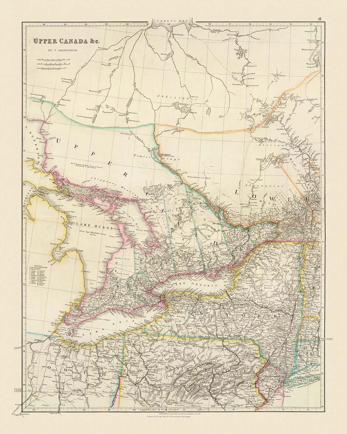
Adéntrese en el refinado mundo de la cartografía del siglo XIX con “Upper Canada &c.” de John Arrowsmith, una obra maestra publicada por primera vez en 1844 en un momento decisivo de la historia canadiense. Este mapa, con su título original exhibido con orgullo, es un testimonio de la reputación de Arrowsmith por su claridad, precisión y elegancia sobria. El mapa captura el Alto Canadá—la actual Ontario—en una época de gran transformación, justo después del Acta de Unión de 1841, que fusionó el Alto y el Bajo Canadá en la Provincia de Canadá. Con una meticulosa atención al detalle, Arrowsmith traza no solo los límites políticos de condados y municipios, sino también el intrincado entramado de ríos, lagos y rutas de transporte que definieron el desarrollo de la región.
John Arrowsmith, vástago de la ilustre dinastía cartográfica Arrowsmith, fue célebre por su enfoque innovador en la elaboración de mapas. Sus atlas, especialmente la edición ampliada de 1842–1844 de la que procede este mapa, son celebrados por su claridad y modernidad, destacando entre las mejores obras geográficas de la época. La inclusión de quince mapas adicionales en esta edición, que abarcan desde Texas hasta los confines de África y Asia, subraya el compromiso de Arrowsmith con una cobertura global integral. Sin embargo, es su cuidadosa delimitación del Alto Canadá—mediante color de contorno y precisas divisiones administrativas—lo que distingue esta pieza, ofreciendo una instantánea de la ambición y organización coloniales en su apogeo.
La calidad artística del mapa se ve igualada por su valor informativo. Los colores de contorno distinguen con elegancia los límites de condados y municipios, mientras que el Distrito de Niagara está representado con una granularidad excepcional, con sus municipios numerados y referenciados para facilitar la consulta. Los principales rasgos naturales—el lago Ontario, el lago Erie, el lago Hurón y el lago Simcoe—anclan el paisaje, mientras que los poderosos ríos Niágara y San Lorenzo trazan los límites de la región con Estados Unidos. Los canales de Welland y Rideau, maravillas de la ingeniería de su tiempo, serpentean por la tierra, conectando asentamientos clave y facilitando el movimiento de bienes y personas en una colonia en rápida modernización.
Más allá de su precisión administrativa y geográfica, el mapa es un registro vivo de las comunidades que darían forma al futuro de Canadá y del noreste de Estados Unidos. Las ciudades de Toronto, Ottawa, Hamilton, Kingston y London están todas presentes, junto con localidades históricas como Niagara-on-the-Lake, Brockville y Cornwall. Al otro lado de la frontera, las ciudades estadounidenses en rápido crecimiento de Buffalo, Rochester y Albany están cartografiadas con igual esmero, al igual que las vías fluviales y rutas de transporte vitales que unen estas regiones. Cada asentamiento, desde la bulliciosa ciudad hasta el tranquilo municipio, se sitúa dentro de un paisaje físico ricamente detallado, marcado por ríos, escarpes e islas.
No se puede exagerar la importancia histórica de “Upper Canada &c.”. Creado en una época en que la región emergía de las disputas coloniales hacia una nueva era de unidad y crecimiento, este mapa encarna el espíritu de exploración, asentamiento y progreso. Ofrece no solo una guía geográfica, sino también una ventana a las ambiciones y logros de su época. Para coleccionistas, historiadores y conocedores de la cartografía de calidad, el mapa de Arrowsmith es a la vez una pieza rara y un testimonio perdurable del arte y la inteligencia que dieron forma al mundo moderno.
Ciudades y localidades en este mapa
- Upper Canada (Ontario):
- Toronto
- Ottawa
- Hamilton
- Kingston
- London
- Niagara (Niagara-on-the-Lake)
- Brockville
- Cornwall
- Chatham
- Belleville
- Cobourg
- Prescott
- Port Hope
- Dundas
- Brantford
- Guelph
- Perth
- Simcoe
- St. Thomas
-
Woodstock
-
Estado de Nueva York:
- Buffalo
- Rochester
- Syracuse
- Albany
- Utica
- Troy
- Oswego
- Lockport
- Auburn
-
Batavia
-
Pensilvania:
- Erie
Características destacadas y hitos
- El río Niágara, que delimita de forma destacada la frontera entre el Alto Canadá y el Estado de Nueva York
- El lago Ontario, mostrado con detalle a lo largo del borde sur del Alto Canadá
- El lago Erie, que forma la frontera meridional del Alto Canadá
- El lago Hurón, representado al noroeste del Alto Canadá
- El lago Simcoe, mostrado en la parte central del Alto Canadá
- El río San Lorenzo, que marca la frontera oriental del Alto Canadá
- El canal Welland, que conecta el lago Erie y el lago Ontario
- El río Ottawa, que forma parte de la frontera nororiental
- El río Grand, que atraviesa la parte occidental del Alto Canadá
- El canal Rideau, que conecta Ottawa con Kingston
- El escarpe del Niágara, indicado como un destacado rasgo físico
- Límites de condado, claramente delineados y rotulados
- Límites de municipio, especialmente detallados en el distrito del Niágara
- Carreteras principales y rutas de transporte, que conectan los asentamientos clave
- Varias islas de los Grandes Lagos, incluidas las del lago Ontario y el lago Erie
Contexto histórico y de diseño
- Título original: Upper Canada &c.
- Creado por John Arrowsmith, un reconocido cartógrafo británico célebre por su claridad, precisión y elegante presentación
- Fechado en 1844, capturando el Alto Canadá justo después del Acta de Unión (1841), que unió el Alto y el Bajo Canadá en la Provincia de Canadá
- Parte de la edición ampliada de 1842-1844 del atlas de Arrowsmith, que incluye quince mapas adicionales de regiones como Texas, África, Asia, Australia y el Caribe
- Edición rara, no registrada en varios catálogos importantes, incluidos Verner, Phillips, el National Maritime Museum y el British Museum World
- La cobertura geográfica incluye todo el Alto Canadá (actual Ontario), todo el Estado de Nueva York y la mayor parte de Pensilvania
- El mapa utiliza color de contorno, sello distintivo del estilo cartográfico claro y elegante de Arrowsmith
- Se centra en fronteras políticas (condados, municipios), geografía física (ríos, lagos) y rutas de transporte (carreteras, canales)
- Destaca por su claridad, detalle geográfico adicional y elegante presentación, lo que lo convierte en un documento notable de los avances cartográficos del siglo XIX
Por favor, revise cuidadosamente las imágenes para asegurarse de que una ciudad o lugar específico aparece en este mapa. También puede ponerse en contacto con nosotros y pedirnos que revisemos el mapa por usted.
Este mapa se ve estupendo en todos los tamaños, pero siempre recomiendo optar por un tamaño mayor si dispone de espacio. Así podrá apreciar fácilmente todos los detalles.
Este mapa se ve increíble en tamaños de hasta 70in (180cm). Si busca un mapa más grande, por favor póngase en contacto.
Tenga en cuenta: las etiquetas de este mapa son difíciles de leer si solicita un mapa de 16in (40cm) o menos. El mapa sigue siendo muy atractivo, pero si desea leerlo con facilidad, compre un tamaño más grande.
El modelo de las imágenes del anuncio sostiene la versión de 16x20in (40x50cm) de este mapa.
La quinta imagen del anuncio muestra un ejemplo de mi servicio de personalización de mapas.
Si busca algo un poco diferente, consulte mi colección de los mejores mapas antiguos para ver si algo más le llama la atención.
Por favor, contácteme para comprobar si una determinada ubicación, punto de referencia o elemento aparece en este mapa.
Esto sería un maravilloso regalo de cumpleaños, Navidad, Día del Padre, despedida laboral, aniversario o inauguración de casa para alguien de las zonas cubiertas por este mapa.
Este mapa está disponible como impresión giclée en papel mate de archivo libre de ácido, o puede comprarlo enmarcado. El marco es un elegante y sencillo marco negro que se adapta a la mayoría de las estéticas. Póngase en contacto si desea un color o material de marco diferente. Mis marcos están acristalados con acrílico de calidad museo, ultratransparente (perspex/acrylite), que es significativamente menos reflectante que el vidrio, más seguro y siempre llegará en perfectas condiciones.
This map is also available as a float framed canvas, sometimes known as a shadow gap framed canvas or canvas floater. The map is printed on artist's cotton canvas and then stretched over a handmade box frame. We then "float" the canvas inside a wooden frame, which is available in a range of colours (black, dark brown, oak, antique gold and white). This is a wonderful way to present a map without glazing in front. See some examples of float framed canvas maps and explore the differences between my different finishes.
For something truly unique, this map is also available in "Unique 3D", our trademarked process that dramatically transforms the map so that it has a wonderful sense of depth. We combine the original map with detailed topography and elevation data, so that mountains and the terrain really "pop". For more info and examples of 3D maps, check my Unique 3D page.
Many of our maps and art prints are chosen as thoughtful gifts for homes, offices, studies and meaningful places.
Choose a framed option for the easiest ready-to-hang gift, or choose an unframed print if the recipient may prefer to select their own frame.
We make orders locally in 23 countries around the world, so gifts can often be produced close to the recipient. This helps them arrive faster, travel more safely, and avoid customs or import duty surprises.
- We can deliver directly to the recipient
- Framed pieces arrive ready to hang
- Unframed prints are carefully packed in a strong protective tube
- Almost every order is made locally, for faster, safer gifting
- 90-day returns give the recipient time to decide
If you are not sure what to choose, please contact us. We can help you pick the right map, size, finish or delivery option.
Para la mayoría de los pedidos, el tiempo de entrega es de aproximadamente 3 días laborables. Los productos personalizados y a medida tardan más, ya que tengo que hacer la personalización y enviártelo para su aprobación, lo cual suele tardar 1 o 2 días.
Tenga en cuenta que los pedidos enmarcados muy grandes suelen tardar más en fabricarse y entregarse.
Si necesitas que tu pedido llegue para una fecha determinada, por favor contáctame antes de hacer el pedido para que podamos encontrar la mejor manera de asegurarnos de que recibas tu pedido a tiempo.
Imprimo y enmarco mapas y obras de arte en 23 países alrededor del mundo. Esto significa que tu pedido se fabricará localmente, lo que reduce el tiempo de entrega y asegura que no se dañe durante el envío. Nunca pagarás aranceles de aduana o impuestos de importación, y pondremos menos CO2 en el aire.
Todos mis mapas y impresiones artísticas están bien empaquetados y enviados en un tubo resistente si no están enmarcados, o rodeados de espuma si están enmarcados.
Intento enviar todos los pedidos dentro de 1 o 2 días después de recibir tu pedido, aunque algunos productos (como mascarillas, tazas y bolsas de tela) pueden tardar más en fabricarse.
Si seleccionas Entrega Exprés al finalizar la compra, priorizaremos tu pedido y lo enviaremos por mensajería de 1 día (Fedex, DHL, UPS, Parcelforce).
La entrega al día siguiente también está disponible en algunos países (EE. UU., Reino Unido, Singapur, EAU), pero por favor intenta hacer tu pedido temprano en el día para que podamos enviarlo a tiempo.
Mi marco estándar es un marco de madera de fresno negro estilo galería. Es simple y tiene un aspecto bastante moderno. Mi marco estándar tiene alrededor de 20 mm (0.8 in) de ancho.
Utilizo acrílico super claro (perspex/acrylite) para el vidrio del marco. Es más ligero y seguro que el vidrio, y se ve mejor, ya que la reflectividad es menor.
Seis colores de marco estándar están disponibles de forma gratuita (negro, marrón oscuro, gris oscuro, roble, blanco y oro antiguo).El enmarcado y montaje/matizado personalizado está disponible si buscas algo diferente.
La mayoría de los mapas, arte e ilustraciones también están disponibles como un lienzo enmarcado. Utilizamos lienzo de algodón mate (no brillante), lo estiramos sobre un marco de madera de caja de origen sostenible, y luego 'flotamos' la pieza dentro de un marco de madera. El resultado final es bastante hermoso, y no hay cristal que se interponga.
Todos los marcos se proporcionan "listos para colgar", con una cuerda o soportes en la parte posterior. Los marcos muy grandes tendrán placas de colgar de alta resistencia y/o un listón de montaje. Si tienes alguna pregunta, por favor ponte en contacto.
Mira algunos ejemplos de mis mapas enmarcados y mapas en lienzo enmarcados.
Alternativamente, también puedo proporcionar mapas antiguos y obras de arte en lienzo, tablero de espuma, papel de algodón y otros materiales.
Si deseas enmarcar tu mapa o obra de arte tú mismo, por favor lee mi guía de tamaños primero.
Mis mapas son reproducciones de mapas originales de altísima calidad.
Obtengo mapas originales y raros de bibliotecas, casas de subastas y colecciones privadas de todo el mundo, los restauro en mi taller de Londres y luego uso tintas e impresoras giclée especializadas para crear hermosos mapas que lucen incluso mejor que el original.
Mis mapas están impresos en papel de archivo mate (no brillante) sin ácido que se siente de muy alta calidad y casi como una tarjeta. En términos técnicos, el peso/grosor del papel es de 10 mil/200 g/m². Es perfecto para enmarcar.
Imprimo con tintas pigmentadas Epson ultrachrome giclée UV resistentes a la decoloración, algunas de las mejores tintas que puedes encontrar.
yo también puedo hacer mapas sobre lienzo, trapo de algodón y otros materiales exóticos.
Obtenga más información sobre The Unique Maps Co..
Personalización de mapas
Si está buscando el regalo perfecto de aniversario o inauguración de la casa, puedo personalizar su mapa para hacerlo verdaderamente único. Por ejemplo, puedo agregar un mensaje corto, resaltar una ubicación importante o agregar el escudo de armas de su familia.
Las opciones son casi infinitas. Por favor mira mi página de personalización de mapas para ver algunos maravillosos ejemplos de lo que es posible.
Para pedir un mapa personalizado, seleccione "personalizar su mapa" antes de agregarlo a su carrito.
Ponerse en contacto si buscas personalizaciones y personalizaciones más complejas.
Envejecimiento del mapa
A lo largo de los años, los clientes me han preguntado cientos de veces si podían comprar un mapa que se viera uniforme. más viejo.
Bueno, ahora puedes hacerlo seleccionando Envejecido antes de agregar un mapa a tu carrito.
Todas las fotografías de productos que ve en esta página muestran el mapa en su forma original. Así es como se ve el mapa hoy.
Si selecciona Envejecido, envejeceré su mapa a mano, usando un proceso especial y único desarrollado a través de años de estudiar mapas antiguos, hablar con investigadores para comprender la química del envejecimiento del papel y, por supuesto... ¡mucha práctica!
Si no estás seguro, quédate con el color original del mapa. Si quieres algo un poco más oscuro y más viejo buscando, opte por Envejecido.
Si no estás satisfecho con tu pedido por cualquier motivo, contáctame para un reembolso sin complicaciones. Por favor, consulta nuestra política de devoluciones y reembolsos para más información.
Estoy muy seguro de que te gustará tu mapa o impresión artística restaurada. He estado haciendo esto desde 1984. Soy un vendedor de 5 estrellas en Etsy. He vendido decenas de miles de mapas e impresiones artísticas y tengo más de 5,000 opiniones reales de 5 estrellas.
Utilizo un proceso único para restaurar mapas y obras de arte que consume mucho tiempo y mano de obra. Buscar los mapas e ilustraciones originales puede llevar meses. Utilizo tecnología de última generación y extremadamente cara para escanear y restaurarlos. Como resultado, garantizo que mis mapas e impresiones artísticas son superiores a los demás - por eso puedo ofrecer un reembolso sin complicaciones.
Casi todos mis mapas e impresiones artísticas se ven increíbles en tamaños grandes (200cm, 6.5ft+) y también puedo enmarcarlos y entregártelos a través de un servicio de mensajería especial para tamaños grandes. Contáctame para discutir tus necesidades específicas.
Or try searching for something!


